Chaim Soutine (Belarusian/French, 1893-1943) - La Petite Fille dans la VerdureFreeman's | Hindman4.5(158)See Sold PriceFeb 27, 2024
Elisabeth Frink (British, 1930-1993) - Harbinger Bird IFreeman's | Hindman4.5(158)See Sold PriceFeb 27, 2024
AMERICAN SEASCAPE PAINTING BY ROSS EMBROSE MOFFETTAntique Arena Inc.4.5(866)See Sold PriceMar 02, 2024
CHARLES HENRY GIFFORD (Massachusetts, 1839-1904), Luminist view of three sailboats in a quietEldred's4.7(418)See Sold PriceFeb 28, 2024
RARE MANHATTAN PROJECT GLASS LEADED FROM THE MANHATTAN PROJECT WORLD WAR II WW2 724 GRAMSCol. Christie Hatman Auctioneers4.5(323)See Sold PriceFeb 26, 2024
Estate Fresh Civil War Cavalry C. Roby 1863 With ScabbardRalph Fontaine Heritage Auctions Inc.4.7(234)See Sold PriceFeb 25, 2024
ABSTRACT ARAB LEBANESE OIL PAINTING BY ETEL ADNANAntique Arena Inc.4.5(866)See Sold PriceMar 02, 2024
SoldMap of Arkansas, Mississippi & Louisiana #59627Civil war era map, double truck, pp. 44,45. Copper engraved & hand colored by Johnson with Rail & Wagon Roads. 2 very small tears (.25" at upper left of border, does not encroach on map). Vivid color.See Sold Price
SoldMitchell: Antique Map of Mississippi Louisiana, 1869Title/Content of Map: Arkansas, Mississippi & Louisiana by Mitchell Date Printed: 1869 Cartographer: Augustus S. Mitchell Material/Medium: Paper Size: 23 1/2" x 15" Hand colored engraved Map. From 'MiSee Sold Price
Map of Arkansas, Mississippi & Louisiana, 1868Original engraving from Johnson's Atlas of the World, 1868. Map details cities, towns and territories. Dimensions: 18" x 26". This item ships from Ocean View, DE.See Sold Price
Antique Map of Arkansas, Mississippi, LouisianaAntique regional map of Arkansas, Mississippi, and Louisiana, on parchment paper, with pink and blue, by Johnson and Ward, image size 24 x 17, framedSee Sold Price
Map of Arkansas, Mississippi & Louisiana, 1868Original engraving from Johnson's Atlas of the World, 1868. Map details cities, towns and territories. Dimensions: 18" x 26". This item ships from Ocean View, DE.See Sold Price
1862 Johnson's Arkansas Mississippi and LouisianaThis is an authentic antique map Arkansas Mississippi and Louisiana of by Johnson & Browning. The map was published in Johnson's Family Atlas in 1862. This map centers on the states of Arkansas MissisSee Sold Price
Sold1866 Johnson Map of Arkansas, Mississippi and LouisianaTitle: 1866 Johnson Map of Arkansas, Mississippi and Louisiana -- Johnson's Arkansas, Mississippi and Louisiana Cartographer: A J Johnson Year / Place: 1866, New York Map Dimension (in.): 17 X 24 in.See Sold Price
1872 Map of Arkansas, Mississippi and LouisianaAuthor: Gamble Title: 1872 Map of Arkansas, Mississippi and Louisiana Medium: Ink on Paper Dimensions: 15"X23" Map dated 1872 engraved by W.H. Gamble. It captures the Southern states of Arkansas, MissSee Sold Price
SoldCounty Map of Arkansas, Mississippi and LouisianaHand-Colored and Engraved County Map of the States of Arkansas, Mississippi and Louisiana, copyright 1886, by Wm. M. Bradley & Bro., sight 21" x 14". Glazed, matted and framed.See Sold Price
1864 Johnson Map of Arkansas, Mississippi and LouisianaTitle: 1864 Johnson Map of Arkansas, Mississippi and Louisiana -- Johnson's Arkansas, Mississippi and Louisiana Cartographer: Johnson and Ward Year / Place: 1864, New York Map Dimension (in.): 17 X 24See Sold Price
1865 Johnson Map of Arkansas, Mississippi and Louisiana -- Johnson's Arkansas, Mississippi andTitle: 1865 Johnson Map of Arkansas, Mississippi and Louisiana -- Johnson's Arkansas, Mississippi and Louisiana Cartographer: Johnson & Ward Year / Place: 1865, New York Map Dimension (in.): 17.4 X 24See Sold Price
Antique map of Arkansas, Mississippi and Louisiana, Mitchell 1874Attractive map of these southern states, with original hand coloring by counties. Shows towns, roads, railroads, rivers, lakes, forts, swamps, islands, bays, sounds and other coastal features. Drawn aSee Sold Price
1850 Map of Arkansas, Mississippi and LouisianaAuthor: Johnson Title: 1850 Map of Arkansas, Mississippi and Louisiana Medium: Ink on Paper Dimensions: 18"X26.5" Map of Arkansas, Mississippi and Louisiana dated 1850. Engraved by A.J. Johnson. PubliSee Sold Price
1866 Johnson Map of Arkansas, Mississippi and LouisianaTitle: 1866 Johnson Map of Arkansas, Mississippi and Louisiana -- Johnson's Arkansas, Mississippi and Louisiana Cartographer: A J Johnson Year / Place: 1866, New York Map Dimension (in.): 17 X 24 in.See Sold Price
SoldTwo Copies of Samuel Augustus Mitchell (1790-1868), "Two Copies of Samuel Augustus Mitchell (1790-1868), " County Map of Arkansas, Mississippi, and Louisiana," 1870, hand colored, H.-15 1/8 in., W.- 23 1/8 in. (2 Pcs.)See Sold Price
1866 Map of Southern StatesAuthor: Johnson Title: 1866 Map of Southern States Materials: Ink on Paper Dimensions: 18"X27" Description: Map of the Southern States dated 1866. This map captures Arkansas, Mississippi and LouisianaSee Sold Price
SoldAN ANTIQUE AMERICAN RECONSTRUCTION ERA MAP, "Johnson'sAN ANTIQUE AMERICAN RECONSTRUCTION ERA MAP, "Johnson's Arkansas, Mississippi, and Louisiana," NEW YORK,1865-1869 hand colored ink engraving on paper, page fragment plates 44 and 45, published bySee Sold Price
SoldJohnson's Map of Arkansas, Mississippi and LAJohnson's Map of Arkansas, Mississippi and Louisiana, 19th Century, published by A. J. Johnson, New York, sight 25" x 19". Glazed, French matted and presented in a bead-carved frame.See Sold Price
SoldAN ANTIQUE AMERICAN RECONSTRUCTION ERA MAP, "Johnson'sAN ANTIQUE AMERICAN RECONSTRUCTION ERA MAP, "Johnson's Arkansas, Mississippi and Louisiana," 1865-1869, hand colored ink engraving on paper, printed by Johnson and Ward, pages 45 and 46 in original atSee Sold Price
SoldJohnson's Map of Arkansas, Mississippi and LouisiaJohnson's Map of Arkansas, Mississippi and Louisiana, 1866, colored print, framed, H.- 24 in., W.- 18 in.See Sold Price
SoldMAP: 1864 Johnsons Arkansas 26 x 18 inchesMaps“Johnson’s Arkansas, Mississippi and Louisiana” c. 1861, “Johnson’s Arkansas, Mississippi and Louisiana,” published by Johnson and Ward, New York, Very Fine. FrSee Sold Price
Sold17 1800's/1900's book plate maps17 1800's/1900's book plate maps including Arkansas Mississippi and Louisiana; Arizona; South Carolina; Ontario; Dominion of Canada; Mexico Central America and West Indies; West Virginia. Most are RanSee Sold Price
SoldARKANSA'S, MISSISSIPPI & LOUISIANA MAPARKANSA'S, MISSISSIPPI & LOUISIANA MAP. Height: 29 in. by Width: 20 in.See Sold Price
Map of Arkansas, Louisiana, Mississippi 1853Map of Arkansas, Louisiana, Mississippi and partials of Indian Territory and Texas Hand colored. Map No 6 United States Cartographer: Jules Sherman Smith Publisher Daniel Burgess DSee Sold Price
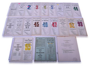
Twenty-Three Kansas City Southern Lines Railway Employee Timetables and General Orders - 1960 toRail & Road Auctions4.6(165)See Sold PriceMar 08, 2024
Kansas City Southern and Louisiana & Arkansas Railway Ticket Dater Die Shreveport 105CRail & Road Auctions4.6(165)See Sold PriceMar 08, 2024
Kansas City Southern Lines Cram's Universal Terrestrial Globe 10 1/2"Rail & Road Auctions4.6(165)See Sold PriceMar 08, 2024
Arrowsmith & Lewis - Map of PolynesiaTrillium Antique Prints & Rare Books4.5(30)See Sold PriceFeb 24, 2024
Arrowsmith & Lewis - Map of North AmericaTrillium Antique Prints & Rare Books4.5(30)See Sold PriceFeb 24, 2024
Arrowsmith & Lewis - Map of the World on Mercator's ProjectionTrillium Antique Prints & Rare Books4.5(30)See Sold PriceFeb 24, 2024
Arrowsmith & Lewis - Map of LouisianaTrillium Antique Prints & Rare Books4.5(30)See Sold PriceFeb 24, 2024
Arrowsmith & Lewis - Map of the United StatesTrillium Antique Prints & Rare Books4.5(30)See Sold PriceFeb 24, 2024
7 5/8" Corn God Found in Mississippi Co Arkansas, minor restoration, Ex Byron Knoblock, Ex Kevin FarHeartland Artifact Auctions4.6(783)See Sold PriceMar 10, 2024
8" Mississippian Fish Effigy Pottery Vessel, Solid found in Mississippi Co Arkansas Ex Sam JohnsonHeartland Artifact Auctions4.6(783)See Sold PriceMar 10, 2024
5" Walls Engraved Water Bottle, Solid, found in Mississippi Co ArkansasHeartland Artifact Auctions4.6(783)See Sold PriceMar 10, 2024
6" Mississippian Dimple Bottle, found in Mississippi Co Arkansas, deconsessioned Arkansas RiverHeartland Artifact Auctions4.6(783)See Sold PriceMar 10, 2024
7 3/4" Fish Effigy Water Bottle, found at Rose Mound , Mississippi Co Arkansas, near Blytheville,Heartland Artifact Auctions4.6(783)See Sold PriceMar 10, 2024
William Tolliver (American/Louisiana & Mississippi, 1951-2000), "Learning to Play," 20th c., H.- 44Crescent City Auction Gallery4.3(231)See Sold PriceMar 08, 2024
William Tolliver (American/Louisiana & Mississippi, 1951-2000), "Four Musicians," 20th c., H.- 30Crescent City Auction Gallery4.3(231)See Sold PriceMar 08, 2024
William Tolliver (Louisiana/Mississippi, 1951-2000), "Bass Player," 20th c., H.- 24 in., W.- 18 in.Crescent City Auction Gallery4.3(231)See Sold PriceMar 08, 2024
William Tolliver (American/Louisiana & Mississippi, 1951-2000), "Mother and Child," 20th c., H.- 30Crescent City Auction Gallery4.3(231)See Sold PriceMar 08, 2024
Two Hand-Colored 19th Century Maps of New Orleans and Louisiana, Larger- H.- 12 1/2 in., W.- 15 1/2Crescent City Auction Gallery4.3(231)See Sold PriceMar 08, 2024
William Tolliver (Louisiana/Mississippi, 1951-2000), "Jazz Guitarist," 20th c., H.- 26 in., W.- 12Crescent City Auction Gallery4.3(231)See Sold PriceMar 09, 2024
John Senex Map of Louisiana & Mississippi RiverWillow Auction House4.5(284)See Sold PriceMar 14, 2024


![[Tintype] Massive Bowie knife (1 of 1)](https://p1.liveauctioneers.com/7226/317626/170485482_1_x.jpg?height=282&quality=70&version=1706368022)
![[Ambrotype] Magnificent Portrait (1 of 1)](https://p1.liveauctioneers.com/7226/317626/170485477_1_x.jpg?height=282&quality=70&version=1706368022)


![[Tintype] Native American Man w/ Knife (1 of 2)](https://p1.liveauctioneers.com/7226/317626/170485453_1_x.jpg?height=282&quality=70&version=1706368022)
![[REES, Charles] Enlistedman w/ Bowie Knife (1 of 1)](https://p1.liveauctioneers.com/7226/317626/170485489_1_x.jpg?height=282&quality=70&version=1706368022)
![[Ambrotype] Wounded at Gettysburg (1 of 1)](https://p1.liveauctioneers.com/7226/317626/170485471_1_x.jpg?height=282&quality=70&version=1706368022)


![[Ambrotype] Young Soldier w/ Bowie Knife (1 of 1)](https://p1.liveauctioneers.com/7226/317626/170485459_1_x.jpg?height=282&quality=70&version=1706368022)

![[Daguerreotype] Soldier w/ Bowie Knife (1 of 2)](https://p1.liveauctioneers.com/7226/317626/170485458_1_x.jpg?height=282&quality=70&version=1706368022)
![[Tintype] Soldier w/ Flowers (1 of 1)](https://p1.liveauctioneers.com/7226/317626/170485495_1_x.jpg?height=282&quality=70&version=1706368022)
![[Tintype] Identified North Carolina Infantryman (1 of 2)](https://p1.liveauctioneers.com/7226/317626/170485474_1_x.jpg?height=282&quality=70&version=1706368022)