SoldCounty Map of Arkansas, Mississippi and LouisianaHand-Colored and Engraved County Map of the States of Arkansas, Mississippi and Louisiana, copyright 1886, by Wm. M. Bradley & Bro., sight 21" x 14". Glazed, matted and framed.See Sold Price
SoldTwo Copies of Samuel Augustus Mitchell (1790-1868), "Two Copies of Samuel Augustus Mitchell (1790-1868), " County Map of Arkansas, Mississippi, and Louisiana," 1870, hand colored, H.-15 1/8 in., W.- 23 1/8 in. (2 Pcs.)See Sold Price
Scarce early Cram RR map of the Deep SouthFrom a very scarce Cram atlas comes this map of the Deep South showing the areas railway system in place in 1882. ”New Railroad and County Map of Arkansas, Louisiana & Mississippi.” The 18See Sold Price
SoldMitchell: Arkansas, Mississippi, Louisiana County MapMap: County Map of the States of Arkansas, Mississippi, and Louisiana Cartographer: S. A. Mitchell Place/Date: Philadelphia / 1870 Size: 13 5/8" x 21" Condition: full color; overall age toning The beaSee Sold Price
SoldMAPS, MITCHELL "PLAN OF NEW ORLEANS", ARKANSASUnframed map by Samuel Augustus Mitchell, Jr., copyright 1882, depicting "Plan of New Orleans, "Country Map of Florida" on one side, "County Map of the States of Arkansas, Mississippi and Louisiana" oSee Sold Price
SoldMAPS: MITCHELL NEW ORLEANS, FLORIDA, ARKANSASUnframed map, Samuel Augustus Mitchell, Jr., copyright 1882, depicting "Plan of New Orleans, "Country Map of Florida" on one side, "County Map of the States of Arkansas, Mississippi and Louisiana" onSee Sold Price
SoldTwo Hand Colored Maps, consisting of "County Map of theTwo Hand Colored Maps, consisting of "County Map of the States of Arkansas, Mississippi and Louisiana," 1867 by W.H. Gamble, Philadelphia; and "Plan of New Orleans," 1867 by S. Augustus Mitchell, bothSee Sold Price
SoldMAPS, MITCHELL "PLAN OF NEW ORLEANS", ARKANSASUnframed map by Samuel Augustus Mitchell, Jr., copyright 1882, depicting "Plan of New Orleans, "Country Map of Florida" on one side, "County Map of the States of Arkansas, Mississippi and Louisiana" oSee Sold Price
Sold"County Map of the States of Arkansas, Mississipp"County Map of the States of Arkansas, Mississippi and Louisiana," 1886, by William Bradley and Bro., framed, H.- 21 1/2 in., W.- 14 in.See Sold Price
Samuel Augustus Mitchell (1790-1868), "County Map ofSamuel Augustus Mitchell (1790-1868), "County Map of the States of Arkansas, Mississippi, and Louisiana," 1867, H.- 23 1/2 in., W.- 15 1/2 in.See Sold Price
Samuel Augustus Mitchell (1790-1868), "County Map ofSamuel Augustus Mitchell (1790-1868), "County Map of the States of Arkansas, Mississippi, and Louisiana," 1872, H.- 23 1/2 in., W.- 15 1/4 in.See Sold Price
Samuel Augustus Mitchell (1790-1868), "County Map ofSamuel Augustus Mitchell (1790-1868), "County Map of the States of Arkansas, Mississippi, and Louisiana," 1867, H.- 23 1/2 in., W.- 15 1/4 in.See Sold Price
Samuel Augustus Mitchell (1790-1868), "County Map ofSamuel Augustus Mitchell (1790-1868), "County Map of the States of Arkansas, Mississippi, and Louisiana," 1871, H.- 25 in., W.- 12 1/2 in.See Sold Price
SoldThree Maps by Samuel Augustus Mitchell (1790-1868), "Three Maps by Samuel Augustus Mitchell (1790-1868), " County Maps of Arkansas, Louisiana and Mississippi, Verso with Florida, and a Plan of New Orleans" 1882, hand colored, on two pages, H.-24 in., W.See Sold Price
SoldAntique County Map of Louisiana, Mississippi, BroAn Antique County Map of Louisiana, Mississippi, and Arkansas , c. 1900, in attractive four-color printing, a double atlas page from Johnson's Atlas (pub. by Johnson A. Browning), 24 in. x 17 1/2 in.See Sold Price
SoldTwo Fine Civil War Era MapsTwo Fine Civil War Era Maps by Samuel Augustus Mitchell, Jr., including "Plan of New Orleans" and "County Map of Louisiana, Mississippi and Arkansas", each hand-colored engraving published PhiladelphiSee Sold Price
Mitchell: Antique Map of Louisiana Arkansas MississippiTitle/Content of Map: 1867 Mitchell Map of Louisiana, Arkansas and Mississippi -- County Map of Louisiana, Mississippi and Arkansas Date Printed: 1867 Philadelphia Cartographer: S Mitchell Size: 21 xSee Sold Price
Mitchell: Antique Map of Louisiana, Arkansas, 1867Title/Content of Map: 1867 Mitchell Map of Louisiana, Arkansas and Mississippi -- County Map of Louisiana, Mississippi and Arkansas Date Printed: 1867 Philadelphia Cartographer: S Mitchell Size: 21 xSee Sold Price
1867 Mitchell Map of Louisiana, Arkansas andTitle/Content of Map: 1867 Mitchell Map of Louisiana, Arkansas and Mississippi -- County Map of Louisiana, Mississippi and Arkansas Date: 1867 Philadelphia Cartographer: S Mitchell Size: 21 x 13.6 in.See Sold Price
Mitchell: Map of Louisiana, Arkansas, Mississippi, 1867Map: 1867 Mitchell Map of Louisiana, Arkansas and Mississippi -- County Map of Louisiana, Mississippi and Arkansas Cartographer: S Mitchell Year / Place: 1867 Philadelphia Map Dimensions: 21 x 13.6 inSee Sold Price
1867 Mitchell Map of Louisiana, Arkansas andTitle/Content of Map: 1867 Mitchell Map of Louisiana, Arkansas and Mississippi -- County Map of Louisiana, Mississippi and Arkansas Date: 1867 Philadelphia Cartographer: S Mitchell Size: 21 x 13.6 in.See Sold Price
Mitchell: Antique Map of Louisiana, Arkansas, 1867Title/Content of Map: 1867 Mitchell Map of Louisiana, Arkansas and Mississippi -- County Map of Louisiana, Mississippi and Arkansas Date Printed: 1867 Philadelphia Cartographer: S Mitchell Size: 21 xSee Sold Price
Antique map of Arkansas, Mississippi and Louisiana, Mitchell 1874Attractive map of these southern states, with original hand coloring by counties. Shows towns, roads, railroads, rivers, lakes, forts, swamps, islands, bays, sounds and other coastal features. Drawn aSee Sold Price
Map of Arkansas, Louisiana, Mississippi 1853Map of Arkansas, Louisiana, Mississippi and partials of Indian Territory and Texas Hand colored. Map No 6 United States Cartographer: Jules Sherman Smith Publisher Daniel Burgess DSee Sold Price
Crams Map of North Dakota-Complete Railroad System and County Map-1907JM Hobby Supply and Railroad Artifact Auctions4.4(126)See Sold PriceFeb 24, 2024
Vintage County Map Of NY State Plate EngravingThe Benefit Shop Foundation Inc.4.3(2.9k)See Sold PriceFeb 28, 2024
Portfolio of 15 County Maps by Robert Morden (English 1650-1703)Nadeau's Auction Gallery4.7(401)See Sold PriceFeb 24, 2024
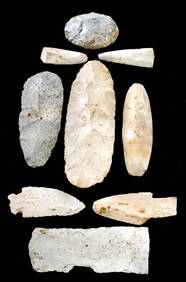
3 1/16" Novaculite Calf Creek. Very striking. Ex Floyd RitterTony Putty Artifacts4.7(404)See Sold PriceMar 09, 2024
4 1/4" Red Avery Jar. Arkansas. Recovered along The Red River.Tony Putty Artifacts4.7(404)See Sold PriceMar 09, 2024
3 9/16" Quartz Butterfly Bannerstone. Ex Col. Jack Roberts and Floyd RitterTony Putty Artifacts4.7(404)See Sold PriceMar 09, 2024
3 3/4" Mini Pot Made of Clay with Red, White and Gray Color. Pictured. Ex Dale RectorTony Putty Artifacts4.7(404)See Sold PriceMar 09, 2024
7 1/4" Human Face Effigy Bowl. Lee Co, AR. Davis and Jackson COA'sTony Putty Artifacts4.7(404)See Sold PriceMar 09, 2024
8 3/8" Engraved Caddo Bottle. Ex Tom Morse. Jackson COATony Putty Artifacts4.7(404)See Sold PriceMar 09, 2024
2 3/8" Grand. Recovered in Saline Co, AR. Ex Ron ComerTony Putty Artifacts4.7(404)See Sold PriceMar 09, 2024
[ENSLAVEMENT & ABOLITION]. Manuscript legal complaint related to the hire of "the negro girl Ellen."Freeman's | Hindman4.4(1.6k)See Sold PriceFeb 27, 2024
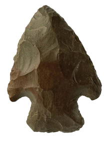
[CIVIL WAR]. Pay Voucher for Private Miles Logan of the 11th Regiment US Colored Troops.Freeman's | Hindman4.4(1.6k)See Sold PriceFeb 27, 2024
John Senex Map of Louisiana & Mississippi RiverWillow Auction House4.5(283)See Sold PriceMar 14, 2024
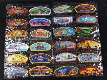
Boy Scout Council Shoulder Badges Lot Of 24 ARapid Estate Liquidators and Auction Gallery4.5(1.1k)See Sold PriceMar 03, 2024


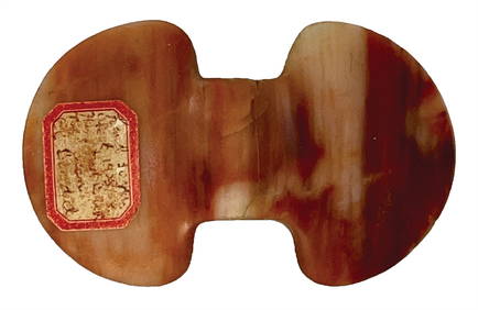


![[ENSLAVEMENT & ABOLITION]. Manuscript legal complaint related to the hire of "the negro girl Ellen." (1 of 2)](https://p1.liveauctioneers.com/197/319238/171468061_1_x.jpg?height=282&quality=70&version=1707520367)
![[CIVIL WAR]. Pay Voucher for Private Miles Logan of the 11th Regiment US Colored Troops. (1 of 2)](https://p1.liveauctioneers.com/197/319238/171468127_1_x.jpg?height=282&quality=70&version=1707520367)