ATLAS of ANTIENT GEOGRAPHY by SAMUEL BUTLER 1843John McInnis Auctioneers,LLC4.6(502)See Sold PriceFeb 24, 2024
18TH C. ANTIQUE MAP: FRENCH & INDIAN WAR, FRAMEDThomaston Place Auction Galleries4.4(386)See Sold PriceFeb 24, 2024
Rand McNally Railroad Map Cabinet w/ 21 Railroad MapsRail & Road Auctions4.6(165)See Sold PriceMar 08, 2024
Keith Haring - Ink on New York Map, Best Buddies, Inscribed, Signed, and DatedSapphire Auction Gallery4(67)See Sold PriceMar 02, 2024
LATE 17TH C. FRENCH MAP OF THE NEW WORLD BY ALEXIS-HUBERT JAILLOT (1632-1712)Thomaston Place Auction Galleries4.4(386)See Sold PriceFeb 24, 2024
Central Railroad of New Jersey Map of Sandy Hook Route-ca. 1903JM Hobby Supply and Railroad Artifact Auctions4.4(126)See Sold PriceFeb 24, 2024
Lot of Six Mixed Atlas Box Cars-HO Scale-New in BoxJM Hobby Supply and Railroad Artifact Auctions4.4(126)See Sold PriceFeb 25, 2024
Rand McNally/Santa Fe Railroad Map of Iowa-1912JM Hobby Supply and Railroad Artifact Auctions4.4(126)See Sold PriceFeb 24, 2024
NICOLAES VISSCHER (NETHERLANDS, 1618-1709) MAP OF THE NEW WORLDThomaston Place Auction Galleries4.4(386)See Sold PriceFeb 24, 2024
17TH C. WORLD MAP BY NICOLAES VISSCHER (NETHERLANDS, 1618-1709)Thomaston Place Auction Galleries4.4(386)See Sold PriceFeb 24, 2024
Lot of Six Mixed Atlas Cabooses-HO Scale-New in BoxJM Hobby Supply and Railroad Artifact Auctions4.4(126)See Sold PriceFeb 25, 2024
MAP, Le Maire Strait, BellinLe Maire Strait. Jacques Nicolas Bellin, Carte du Detroit de Le Maire, Dressee sur les Journaux des Navigateurs, from Abrege de l'Histoire Generale des Voyages, 1753 (dated). Hand Color. This chart ilSee Sold Price
SoldBellin: Le Maire Strait / Tierra del FuegoMap Title: Carte du Detroit de le Maire Cartographer: Bellin Place / Date: Paris / 1753/1760 Size: 10 7/8" x 7 5/8" Condition: b&w; light overall age toning; margins extended with contemporary paper tSee Sold Price
Bellin: Le Maire Strait / Tierra del FuegoMap Title: Carte du Detroit de le Maire Cartographer: Bellin Place / Date: Paris / 1753/1760 Size: 10 7/8" x 7 5/8" Condition: b&w; light overall age toning; margins extended with contemporary paper tSee Sold Price
Detroit de Le Maire' Strait, Tierra del Fuega,TITLE OF THE MAP: 'Carte du Detroit de le Maire Dressée sur les journaux des navigateurs Par Sr. Bellin Ingénieur de la Marine et du Dépost des plans de l'Académie de marine et de la Société RoySee Sold Price
Bellin: Map of Le Maire Strait/Tierra del Fuego, 1753Carte du Detroit de le Maire Bellin's beautifully rendered map of a key passage between the Atlantic and Pacific Oceans, the Le Maire Strait between Tierra del Fuego and Staten Island. The chart incluSee Sold Price
Bellin: Le Maire Strait/Tierra del FuegoReserve Reduced! Bellin's beautifully rendered map of a key passage between the Atlantic and Pacific Oceans, the Le Maire Strait between Tierra del Fuego and Staten Island. The chart includes good coaSee Sold Price
Detroit de Le Maire' Strait, Tierra del Fuega,TITLE OF THE MAP: 'Carte du Detroit de le Maire Dressée sur les journaux des navigateurs Par Sr. Bellin Ingénieur de la Marine et du Dépost des plans de l'Académie de marine et de la Soci�See Sold Price
Antique Map - Tierra del Fuego - Le Maire Strait - Bay of Good Success - J. CookThis captivating engraving map by Captain James Cook originates from "An Account of the Voyages Undertaken by the Order of His Present Majesty for Making Discoveries in the Southern Hemisphere" by JohSee Sold Price
SoldJ. DE HONDT, COLOR MAP OF STRAITS OF MAGELLANJoost de Hondt (Belgian 1563-1612), "Freti Magel Lanici Ac Novi Freti Vulgo, Le Maitre Exactissima Delineatio", hand colored map of the Straits of Magellan, Le Maire Strait, Fire Lands and the southerSee Sold Price
Carte Du Detroit De Le Maire,Title/Content of Map: Carte Du Detroit De Le Maire, Date Printed: 1753 Cartographer: BELLIN, JACQUES NICOLAS (1703-1772) Size: 7.75X11 "Dressee sur les Journaux des navigateurs. Par le Sr. Bellin IngeSee Sold Price
SoldEarly navigational map(lot of 2) unframed 1753 Early navigational map of the Straits of Le Maire, 7.5'' x 10.75'', together with an unframed 1748 map detailing Pacific Coast navigation and California, 14'' x 23''See Sold Price
1756 Straits of Le Maire, Terra del Fuego, Argentina, by G. AnsonTitle: 1756 Straits of Le Maire, Terra del Fuego, Argentina, by G. Anson Date/Period: 1756 Materials: Copper plate engraved Size: 21” x 11 ” This 1756 map depicts the Straits of Le Maire,See Sold Price
Soldc.1781 Two Maps: Captain Cook VoyagesMapsc. 1781, Dual Map “A Plan of Success Bay in Strait Le Maire / A Chart of the S.E. part of Terra del Fuego, including Strait le Maire and part of Staten Land by Captn. Cook 1769", Extremely FSee Sold Price
Soldc.1781 Two Maps: Captain Cook VoyagesMapsc. 1781, Dual Map “A Plan of Success Bay in Strait Le Maire / A Chart of the S.E. part of Terra del Fuego, including Strait le Maire and part of Staten Land by Captn. Cook 1769", Extremely FSee Sold Price
Soldc.1781 Two Maps: Captain Cook VoyagesHistoric Maps c. 1781, Dual Map “A Plan of Success Bay in Strait Le Maire / A Chart of the S.E. part of Terra del Fuego, including Strait le Maire and part of Staten Land by Captn. Cook 1769", ExtreSee Sold Price
Soldc.1781 2 Maps-Captain Cook Voyagesc. 1781, Dual Map “A Plan of Success Bay in Strait Le Maire / A Chart of the S.E. part of Terra del Fuego, including Strait le Maire and part of Staten Land by Captn. Cook 1769", Extremely Fine.See Sold Price
Sold17th c. Map of Straits of Magellan by Henricus HondiusEarly 17th century map titled "Freti Magellanici ac novi Freti vulgo Le Maire exactissima delineatio" showing the Straits of Magellan and southern tip of South America by Jodocus Hondius. Framed map mSee Sold Price
SoldSouth America.- Jansson (Jan) Freti Magellanici ac noviSouth America.- Jansson (Jan) Freti Magellanici ac novi Freti vulgo Le Maire exactissim delineatio, map of Tierra del Fuego and the Strait of Magellan, engraving on laid paper without visible watermarSee Sold Price
Sold[Hondius (Henricus)] Freti Magellanici[Hondius (Henricus)] Freti Magellanici ac novi Freti vulgo Le Maire exactissima delineatio, engraved map of southern South America showing the Magellan Straits, part of Tierra del Fuego, penguSee Sold Price
Captivating map of Strait of MagellanHeading: Author: Montanus, Arnoldus / John Ogilby Title: Tabula Magellanica, qua Tierrae del Fuego, cum celeberrimis fretis a F. Magellano et I. Le Maire detectis Place Published: London Publisher:See Sold Price
MAP, Strait of Magellan, JanssonStrait of Magellan, Tierra del Fuego. Jan Jansson, Freti Magellanici ac Novi Freti Vulgo Le Maire Exactissima Delineatio, from Atlas Novus, 1647 (published). Hand Color. This is a beautifully decorateSee Sold Price
SoldCaptivating map of Strait of MagellanHeading: Author: Montanus, Arnoldus / John Ogilby Title: Tabula Magellanica, qua Tierrae del Fuego, cum celeberrimis fretis a F. Magellano et I. Le Maire detectis Place Published: London Publisher:See Sold Price
SoldHenricus Hondius map of South AmericaCartographer: Henricus Hondius Title: Freti Magellanici ac novi Freti vulgo le Maire exactissima delineatio Subject: South America Published: Amsterdam Date: c. 1630 Description: Map of the Straits ofSee Sold Price
SoldJansson. FRETI MAGELANICI... [ca. 1640].[Strait of Magellan]. J. Jansson. FRETI MAGELANICI AC NOVI FRETI VULGO LE MAIRE EXACTISSIMA DELINEATIO. c. 1640. Double-page engraved map, 15” x 19”. Outline color. Moderately soiled, few small spSee Sold Price
Van Houtte - Lady's Slipper OrchidTrillium Antique Prints & Rare Books4.5(30)See Sold PriceFeb 24, 2024
1764 Bellin Map of Eastern Guadeloupe in the Lesser Antilles -- Partie Orientale de l'Isle de laJasper524.5(9.8k)See Sold PriceFeb 27, 2024
1764 Bellin Map of Mari-Galante Near Guadeloupe -- Carte de l'Isle de Mari-GalanteJasper524.5(9.8k)See Sold PriceFeb 27, 2024
1764 Bellin Map of St. Kitts -- Carte de l'Isle St. ChristopheJasper524.5(9.8k)See Sold PriceFeb 27, 2024
1764 Bellin Map of Southern Portion of Martinique -- Partie Meridionale de la MartiniqueJasper524.5(9.8k)See Sold PriceFeb 27, 2024
1764 Bellin Chart of Three South Haitian Bays -- Carte des Bayes du Mesle des Flamands et deJasper524.5(9.8k)See Sold PriceFeb 27, 2024
1764 Bellin Map of Port Antonio, Jamaica -- Plan des Havres de Port Antonio et de Saint FrancoisJasper524.5(9.8k)See Sold PriceFeb 27, 2024
Coste Occidentale d’Afrique…' Arguin Bay Cap Blanc Mauritania. BELLIN 1746 mapJasper524.5(9.8k)See Sold PriceFeb 28, 2024
Carte du Golfe de Guinée'. Gulf of Guinea. Nigeria & Cameroon. BELLIN 1747 mapJasper524.5(9.8k)See Sold PriceFeb 28, 2024
Coste Orientale d’Afrique…' South Africa. Mozambique channel. BELLIN 1746 mapJasper524.5(9.8k)See Sold PriceFeb 28, 2024
Coste Occidentale d’Afrique…' West Africa. Gulf of Guinea. BELLIN 1746 mapJasper524.5(9.8k)See Sold PriceFeb 28, 2024
Coste Occidentale d’Afrique…' Namibia South Africa Angola coast BELLIN 1746 mapJasper524.5(9.8k)See Sold PriceFeb 28, 2024
Charles Antoine Lemaire (1800 - 1871) - Set of 4 Botanical Prints - Rose - Camellia Duchesse deProverde Auctions4.3(3)See Sold PriceFeb 28, 2024
Charles Antoine Lemaire (1800 - 1871) - Set of 4 Botanical Prints - Brassavola fragias - BerberioProverde Auctions4.3(3)See Sold PriceFeb 28, 2024
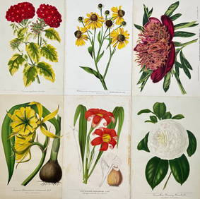
Charles Antoine Lemaire (1800 - 1871) - Set of 6 Botanical Prints - Ismene amancaes - Camellia FannyProverde Auctions4.3(3)See Sold PriceFeb 28, 2024
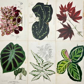
Charles Antoine Lemaire (1800 - 1871) - Set of 6 Botanical Prints - Alocasia - Calathea roseopicta -Proverde Auctions4.3(3)See Sold PriceFeb 28, 2024
Charles Antoine Lemaire (1800 - 1871) - Set of 8 Botanical Prints - Alstraemeria Argento - CayaponiaProverde Auctions4.3(3)See Sold PriceFeb 28, 2024
Charles Antoine Lemaire (1800 - 1871) - Set of 8 Botanical Prints - Embothrium coccineum -Proverde Auctions4.3(3)See Sold PriceFeb 28, 2024


![[Hondius (Henricus)] Freti Magellanici (1 of 1)](https://p1.liveauctioneers.com/410/3027/1300321_1_x.jpg?height=282&quality=70)


![Jansson. FRETI MAGELANICI... [ca. 1640]. (1 of 6)](https://p1.liveauctioneers.com/179/49347/23134495_1_x.jpg?height=282&quality=70&version=1388425910)