ATLAS of ANTIENT GEOGRAPHY by SAMUEL BUTLER 1843John McInnis Auctioneers,LLC4.6(502)See Sold PriceFeb 24, 2024
18TH C. ANTIQUE MAP: FRENCH & INDIAN WAR, FRAMEDThomaston Place Auction Galleries4.4(386)See Sold PriceFeb 24, 2024
Rand McNally Railroad Map Cabinet w/ 21 Railroad MapsRail & Road Auctions4.6(165)See Sold PriceMar 08, 2024
Keith Haring - Ink on New York Map, Best Buddies, Inscribed, Signed, and DatedSapphire Auction Gallery4(67)See Sold PriceMar 02, 2024
LATE 17TH C. FRENCH MAP OF THE NEW WORLD BY ALEXIS-HUBERT JAILLOT (1632-1712)Thomaston Place Auction Galleries4.4(386)See Sold PriceFeb 24, 2024
Central Railroad of New Jersey Map of Sandy Hook Route-ca. 1903JM Hobby Supply and Railroad Artifact Auctions4.4(126)See Sold PriceFeb 24, 2024
Lot of Six Mixed Atlas Box Cars-HO Scale-New in BoxJM Hobby Supply and Railroad Artifact Auctions4.4(126)See Sold PriceFeb 25, 2024
Rand McNally/Santa Fe Railroad Map of Iowa-1912JM Hobby Supply and Railroad Artifact Auctions4.4(126)See Sold PriceFeb 24, 2024
NICOLAES VISSCHER (NETHERLANDS, 1618-1709) MAP OF THE NEW WORLDThomaston Place Auction Galleries4.4(386)See Sold PriceFeb 24, 2024
17TH C. WORLD MAP BY NICOLAES VISSCHER (NETHERLANDS, 1618-1709)Thomaston Place Auction Galleries4.4(386)See Sold PriceFeb 24, 2024
Lot of Six Mixed Atlas Cabooses-HO Scale-New in BoxJM Hobby Supply and Railroad Artifact Auctions4.4(126)See Sold PriceFeb 25, 2024
Map and Four Booklets about the Dutch Colony SurinameA map and four booklets by Jewish authors about the Dutch colony Suriname in South America. 1. Plan de la Ville de Paramaribo, map of Paramaribo, the capital of Suriname. Engraving (out of a book). [FSee Sold Price
SoldPropaganda Poster Dutch Colony Suriname NSB NaziOriginal vintage Dutch propaganda poster titled in Dutch Eens met bloed en zweet verworven voor ons volk, nu verraden en verkswanseld - Geen waarachtig nederlander zal deze schanddaad aanvaarden... -See Sold Price
The Dutch colony of the Cape of Good Hope. South AfricaTITLE/CONTENT OF MAP: 'The Dutch colony of the Cape of Good Hope by L.S. De La Rochette' The top image on the right hand side shows the entire map. To view a close up of the map showing the level of pSee Sold Price
The Dutch colony of the Cape of Good Hope. South AfricaTITLE/CONTENT OF MAP: 'The Dutch colony of the Cape of Good Hope by L.S. De La Rochette' The top image on the right hand side shows the entire map. To view a close up of the map showing the level of pSee Sold Price
The Dutch colony of the Cape of Good Hope. South AfricaTITLE/CONTENT OF MAP: 'The Dutch colony of the Cape of Good Hope by L.S. De La Rochette' The top image on the right hand side shows the entire map. To view a close up of the map showing the level of pSee Sold Price
SoldScarce Hudson-Fulton Celebration TapestryA woven tapestry with the Roman numerals for 1626 at center top for the year Manhatten was purchased from the Native Americans by the Dutch, and showing map of the Dutch colony in North America entitlSee Sold Price
Suriname Stamp Collection MintSuriname - (Dutch Colony) Mint Stamp Collection-Great collection of mint stamps of Surinam,Professionall presented-Attractive albums over 330 stampsSee Sold Price
Sold19th C Dutch Colonies engraving map19th C Dutch Colonies engraving map. 22 1/2” H x 17” W. Shipping in USA is $ 60.00. International bidders ask for shipping before bid.See Sold Price
SoldFour Booklets Concerning Eretz Israel Colonies,1. "Yesod HaMa'alah…" by Yehiel Bril. Printed by the author, Mainz, [1883]. 2. "Di menorah fun Eretz Israel, statistishe zipern tzenoiyf gekliben", by Zvi Ze'ev Frankenfeld. Odessa: A. Shultze pSee Sold Price
SoldFramed Wm. Blaeu Nova Belgica Et Anglia MapLovely example of the Wm. Blaeu map of the Dutch & British colonies in North America, C. 1650. Sight size, 15.25" x 19.75". "Nova Belgica Et Anglia Nova", handwritten (?) 1650 below. Colored. In R. VaSee Sold Price
Sold19thc Map of New Netherland, 17thc Dutch Colony1879 bookplate print, wood engraving, map of New Netherland ( 17thc Dutch Colony ) after an original 1656 map of A. Vanderdonck. 6" X 9 1/2" page size. 4 1/4" X 7" map size. New Netherland was comSee Sold Price
SoldFOUR FRAMED MAPS. Dutch. Three are framed to showFOUR FRAMED MAPS. Dutch. Three are framed to show the text on the back of the double pages. One map of Costa Rica, Guatemala and Panama, and a historic map of the Celtic regions during the Roman EmpirSee Sold Price
SoldJames Hardie THE DESCRIPTION OF THE CITY OF NEW-YORKJames Hardie THE DESCRIPTION OF THE CITY OF NEW-YORK 1827 Leatherbound Hand-Colored Fold-Out Map S Marks Discovery of America Dutch Colony Negro Plot Sir Charles Hardie Evacuation British Census PubliSee Sold Price
SoldHollywood Strips/Filmstars Album. Group of Uncut SheetsHollywood Strips/Filmstars Album. Group of Uncut Sheets of Dutch Photo-Booklets. Circa 1940s. Four uncut sheets (18 ¾ x 3 ½”) with color depictions of John Wayne, Roy Rogers, Gene Autry, Doris DaySee Sold Price
SoldApollo Mission 12 Lunar Photography Indexes. AApollo Mission 12 Lunar Photography Indexes. A booklet of four lunar index maps illustrating the surface coverage and view angles of orbital photography during Apollo 12. Cameras include 70-mm, experSee Sold Price
SoldSet of four 18th century Dutch maps, 28" x 24".Set of four 18th century Dutch maps, 28" x 24".See Sold Price
SoldGerard Van Keulen (1678-1726, Dutch), "Map of the CoastGerard Van Keulen (1678-1726, Dutch), "Map of the Coast of Suriname," c. 1720, hand colored copper engraving, presented in a gilt frame, H.- 20 1/2 in., W.- 34 1/2 in.See Sold Price
SoldALASKA FOUR BOOKLETS BOUND VOL 1890'SALASKA, FOUR BOOKLETS BOUND IN ONE VOLUME. RE: ALASKA: INCLUDES "MAP OF ALASKA" SHOWING KNOWN GOLD BEARING ROCKS, WASHINGTON 1898. 44 PGS WITH LARGE FOLD OUT MAPS. "ALASKA HANDBOOK 84", WASHINGTON 189See Sold Price
SoldFaden (W.) Dutch Colony of Cape of Good HopeFaden (William) The Dutch Colony of the Cape of Good Hope,relief map of the Cape with large title vignette of Europeans elephant hunting on horseback, engraved map with hand-colouring to CapeSee Sold Price
The Dutch colony of the Cape of Good Hope. South Africa Cape Town FADEN 1795 mapTitle: The Dutch colony of the Cape of Good Hope. South Africa Cape Town FADEN 1795 map Description: The Dutch colony of the Cape of Good Hope by L.S. De La Rochette' by Louis Stanislas d'Arcy DelarocSee Sold Price
Four Dutch pewter bowls. Among other things; Tiel,Four Dutch pewter bowls. Among other things; Tiel, Amsterdam, colony. Approx. 1910 - 1930. Dimensions: Ø 26 - 27 cm. In good condition.See Sold Price
A SET OF FOUR DUTCH HAND COLORED COPPER PLATEA SET OF FOUR DUTCH HAND COLORED COPPER PLATE CARTOGRAPHIC ENGRAVINGS BY FREDERICK DE WIT (Dutch 1630-1706), "...REGNI ANGLIAE...," "...BELGII HISPANICI GALLICI...," "DUCATUS SLESVICENSIS...," "INSULASee Sold Price
WORLD post WW2 British French Dutch Belgian colonies. BARTHOLOMEW 1947 old mapTITLE/CONTENT OF MAP: 'World Political (1946)' DATE PRINTED: 1947 IMAGE SIZE: Approx 34.5 x 44.5cm, 13.5 x 17.5 inches (Large); Please note that this is a folding map. TYPE: Vintage colour atlas map CSee Sold Price
La Guyane Françoise, avec partie de la G. Hollandoise.TITLE/CONTENT OF MAP: 'La Guyane Françoise, avec partie de la Guyane Hollandoise' A map of French Guiana, with part of Dutch Guyana (Suriname) Date: 1780 IMAGE SIZE: Approx 34.0 x 23.5cm, 13.25 x 9.2See Sold Price
Ohio and Pennsylvania RR 1st Annual Report-1849JM Hobby Supply and Railroad Artifact Auctions4.4(126)See Sold PriceFeb 24, 2024
Crams Township and Railroad Map of Pennsylvania-1898JM Hobby Supply and Railroad Artifact Auctions4.4(126)See Sold PriceFeb 24, 2024
Rand McNally Railroad Map of Arizona-1909JM Hobby Supply and Railroad Artifact Auctions4.4(126)See Sold PriceFeb 24, 2024
New York Central and Hudson River RR Public Timetable-November 3, 1901JM Hobby Supply and Railroad Artifact Auctions4.4(126)See Sold PriceFeb 24, 2024
MARTINET / DE VRIES Catechism of Nature 4 Vol. Set c1788 Engravings Rare!Luis Porretta Fine Arts4.3(10)See Sold PriceMar 02, 2024
18 Booklets Collection - War Graves of Palestine - WWILevy Auction House4.3(11)See Sold PriceFeb 27, 2024
An early Dutch hand colored engraving map by Georg Balthasar Probst (1732-1801)Ostantix Auctions4.4(10)See Sold PriceFeb 27, 2024
Thirty Pieces of Lackawanna Railroad Ephemera - Chief Engineer Timebook, Map, Public Timetables,Rail & Road Auctions4.6(165)See Sold PriceMar 07, 2024
[LITHOGRAPHY]. [BOOKLETS OR PAMPHLETS]. Group of 10 Booklet...Potter & Potter Auctions4.6(539)See Sold PriceMar 07, 2024
[LITHOGRAPHY]. [INSURANCE]. Group of Eight Trade Cards, Cal...Potter & Potter Auctions4.6(539)See Sold PriceMar 07, 2024
Willem Blaeu, Etc. 17th C. Antiquarian Maps, 2Auctions at Showplace4.5(726)See Sold PriceMar 17, 2024
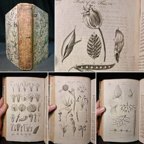
1797 Universal Magazine BOTANY PLATES Flowers FRUIT 12 Copper Engraved PlatesPrivate NY Collection4.2(21)See Sold PriceMar 01, 2024
1738 BIBLE in DUTCH ILLUSTRATED w/ MAPS MASSIVE FOLIO in DUTCH antique BIBLIAJasper524.5(9.8k)See Sold PriceFeb 27, 2024
Pieter Mortier (1661-1711) - Set of 2 Biblical Engravings - "Death of Herod Agrippa" - "PaulProverde Auctions4.3(3)See Sold PriceFeb 28, 2024
Pieter Mortier (1661-1711) - Set of 2 Biblical Engravings - "The apostles Paulus and Barnabas in theProverde Auctions4.3(3)See Sold PriceFeb 28, 2024


![[LITHOGRAPHY]. [BOOKLETS OR PAMPHLETS]. Group of 10 Booklet... (1 of 1)](https://p1.liveauctioneers.com/928/318880/171361043_1_x.jpg?height=282&quality=70&version=1707501302)
![[LITHOGRAPHY]. [INSURANCE]. Group of Eight Trade Cards, Cal... (1 of 1)](https://p1.liveauctioneers.com/928/318880/171361067_1_x.jpg?height=282&quality=70&version=1707501302)