SoldLow Countries.- A mixed group of maps and plans ofLow Countries.- A mixed group of maps and plans of Holland and Belgium,by or after Tardieu, Harrewyn, Kitchin, Archer and others, including SDUK and Tallis plans of Brussels, engraved and lithSee Sold Price
Europe. a mixed group of mapsEurope.- a mixed group of maps mostly national and regional maps of Germany, Austria, Denmark, the Low Countries, Croatia and elsewhere, by or after Mercator, Tirion, Vaugondy, Bowen, Cary, anSee Sold Price
Soldmixed group of maps of the West CountryWest Country.- a mixed group of maps of the West Country,Avon and Somerset, Dorset, Devon and Cornwall, mostly county maps, but including town plans of Bristol and Plymouth, by or after Bowen,See Sold Price
SoldA mixed group of regional maps and plans of England andincluding a locally published cloth Map of the Country Eight Miles Round Malvern, by H. Lamb & Son; a locally published cloth 'weather-proof' edition of Bacon's map of the Isle of Wight, by W. CouldreSee Sold Price
SoldA Mixed Group Of Weekly Dispatch MapsA Mixed Group Of Weekly Dispatch Maps,lithographed map sheets, including town plans, county and country maps, from the Weekly Dispatch Atlas, by or after E. Weller, J. Dower, J.W. Lowry, T. ESee Sold Price
Sold-. large mixed group of maps, plans, and topograp-. large mixed group of maps, plans, and topographical views (A)including maps of Europe, Asia Minor, and with plans of Venice and Rome, an elevation of the facade of the Orangery at VersaillSee Sold Price
SoldLow Countries.- A mixed group of views in HollandLow Countries.- A mixed group of views in Holland and Belgium,including Amsterdam, Haarlem, Brussels and Ghent, a few costume plates, genre scenes and rural landscapes, engravings and lithograSee Sold Price
SoldLow Countries.- by or after Brueghel, Ruisdael, LLow Countries.- a mixed group of landscapes and coastal scenes, by or after Brueghel, Ruisdael, Le Bas, Morin and others, also 5 long plates depicting a procession, engravings and lithographs,See Sold Price
SoldGreek Islands.- a mixed group of maps and plansGreek Islands.- a mixed group of maps and plans,including Tobias Conrad Lotter's Graeciae Antiquae Designatio Nova ..., and with maps by or after Kauffer, Tardieu, d'Anville, and others, engraSee Sold Price
SoldMediterranean.- A mixed group of maps and plansMediterranean.- A mixed group of maps and plans,including 43 maps by Joseph Roux, from 'Plans et Rades de la Méditerraneé', and others by or after Tardieu, Bernard, Gouffier, and others, engraSee Sold Price
Solda mixed group of maps and plansa mixed group of maps and plans,including maps by or after Blome, Bowen, Arrowsmith, and others, mainly of the Middle East, particularly of the Levant, with a small section of plates relatingSee Sold Price
SoldEurope. a mixed group of maps and plansEurope. a mixed group of national and regional maps and plans,including A New Map of Muscovy, from the English edition Olearius's The Voyages & Travels of the Ambassador Sent by Frederick DukeSee Sold Price
SoldA mixed group of maps and plans of London and envA mixed group of maps and plans of London and environs,City Wards, plans for reconstructing the City after the Great Fire, maps of 20 miles around London, some incomplete sections of larger sSee Sold Price
SoldLondon.- Mixed group London plansMixed group of maps and plans of London,including a small group of city ward plans from Stow's Survey,1755, several by Stockdale, including Stepney, Limehouse, Peckham, Hampstead, Greewich anSee Sold Price
SoldA small, mixed group of maps and town plans of EnBritish Isles.- A small, mixed group of maps and town plans of England and Scotland, including several of Kent and the Isle of Thannet, the Isle of White, road maps and town plans, including TSee Sold Price
SoldA small, mixed group of national maps and town plBritish Isles.- A small, mixed group of national maps and town plans, including plans of New York, Brussels, Liverpool, Odessa and others, mostly European, engraved and lithographic maps, someSee Sold Price
SoldHouse Of Commons. mixed plans of LondonHouse Of Commons. Publisher A mixed group of plans and maps of London, including several of Downing Street and the Foreign Office, several of the Embankment and sewer networks, several plans oSee Sold Price
SoldCambridgeshire.- a mixed group of county mapsCambridgeshire.- a mixed group of small county maps,some with inset plans or vignette views and other ornamentation, by, for or after Blome, Cary, Moll, Morden, Moule, Ramble, Rocque, Seller,See Sold Price
SoldA mixed group of maps of North AmericaA mixed group of maps of North America,including a plan of New York, and parts of Canada, by Sidney Hall, Johnston, Day & Son, and others, engravings, lithographs, some printed in colour, v.sSee Sold Price
SoldCambridgeshire.- a mixed group of county maps-. a mixed group of small county maps,including a detailed plan of Bury St Edmunds, by Henshall after Dawson, and the Fens of the Bedford Levels, by R. Walker, some of the county maps with insSee Sold Price
SoldFWOR A large mixed group of maps of various countrFWOR A large mixed group of maps of various countries around the worldincluding the countries around of the Caribbean, Yugoslavia, U.S.A., Spain, France, Italy, Canada, the Lebanon, Norway andSee Sold Price
SoldMercator (Gerard) 4 maps of the Low CountriesMercator (Gerard) a small group of maps of the Low Countries,including 3 of Flanders, also Ducatus Limburg and Geldria et Transysulana, 5 engraved maps, v.s., 350 x 460mm. to 400 x 505mm., allSee Sold Price
Plan of the City of Doway, 1740Map: Plan of the City of Doway ... a Strong City in the Earldom Of Flanders in The Low Countries, Subject to The French Maker: Basire Tindal Date: 1740 Size: Folio, 14.5 inches high x 18.60 inches widSee Sold Price
SoldEurope.- A mixed group of mapsEurope.- A mixed group of maps,including regional and national maps, with the 'Plans of the provinical towns of Ireland for Mr Tindal's Continuation of Mr Rapin's History', a map of BirminghamSee Sold Price
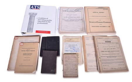
Assortment of Railroad Paper - Rule Books, Stationary, Ink Blotter, Map, Timetables, and MoreRail & Road Auctions4.6(165)See Sold PriceMar 07, 2024
Group of Lake Shore & Michigan Southern Railroad PaperRail & Road Auctions4.6(165)See Sold PriceMar 07, 2024
Group of Ten Railroad Photographs, Maps, and Prints - New Jersey, Long Island, and New YorkRail & Road Auctions4.6(165)See Sold PriceMar 07, 2024
Rosenthal Theodor Karner Porcelain Kitten FigurineLion and Unicorn4.8(1.9k)See Sold PriceFeb 27, 2024
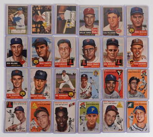
24PC 1952-54 Topps Baseball Estate Card GroupBruneau & Co. Auctioneers4.5(491)See Sold PriceFeb 24, 2024
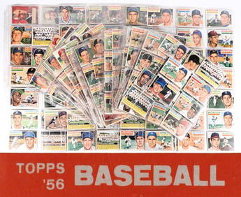
275+ 1956 Topps Baseball Trading Card CollectionBruneau & Co. Auctioneers4.5(491)See Sold PriceFeb 24, 2024
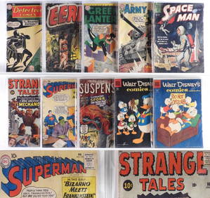
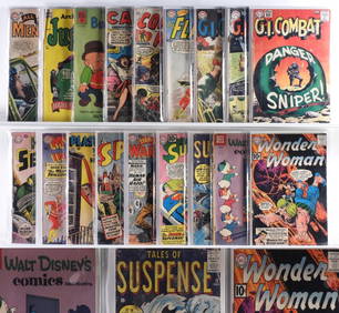
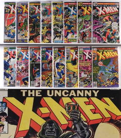
10PC Atlas DC Dell Golden Silver Age Comics GroupBruneau & Co. Auctioneers4.5(491)See Sold PriceFeb 24, 2024
18 Atlas DC Quality Comics Golden Silver Age GroupBruneau & Co. Auctioneers4.5(491)See Sold PriceFeb 24, 2024
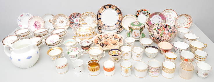
Enormous Lot of Assorted Fine PorcelainOld Kinderhook Auction Company4.6(217)See Sold PriceMar 05, 2024
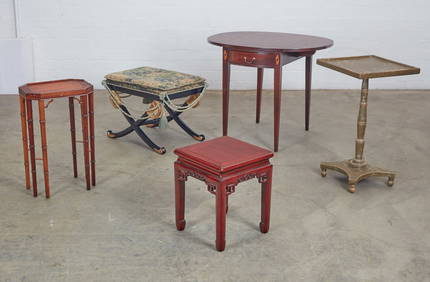
Mixed Group of Ten American Federal Carved Mahogany Dining Chair, early 19th c., Largest Armchair-Crescent City Auction Gallery4.3(231)See Sold PriceMar 09, 2024
T. Kelly - Plan of Bruseels - Battle of Waterloo, London - History of the French RevolutionProverde Auctions4.3(3)See Sold PriceFeb 28, 2024


![World Coins - Mixed Coin Group [118] (1 of 1)](https://p1.liveauctioneers.com/1191/317894/170617515_1_x.jpg?height=282&quality=70&version=1706620797)