SoldLarge-scale world map in two hemispheres prepared by N.Mappe-Monde Geo-Hydrographique...Alexis-Hubert Jaillot (1632-1712). Engraved map with original hand color. Amsterdam: P. Mortier, 1691. 24 1/2 x 38 1/4 inches sheet, 35 1/2 x 49 1/2 inches framed. LarSee Sold Price
Sayer (Robert) - A New Map of the World in Twolarge world map charting the circumnavigatory voyages of Dampier and Anson, with inset hemispheres of the poles to upper corners, and of the solstices in the lower, extensive text panels around and beSee Sold Price
Sayer (Robert) - A New Map of the World in Twolarge world map charting the circumnavigatory voyages of Dampier and Anson, with inset hemispheres of the poles to upper corners, and of the solstices in the lower, extensive text panels around and beSee Sold Price
Teesdale New Chart of the WorldHenry Teesdale (Publisher) and John Dover (Engraver) A New Chart of the World on Mercator's Projection... Hand-colored Engraving London, 1845 Framed: 45 1/2" x 58" This large-scale British two-part maSee Sold Price
MAPS IN BOOK, Arizona, HintonOne of the Earliest Large-Scale Maps of Arizona Territory. Arizona. Richard J. Hinton, Map of Arizona Prepared Specially for R.J. Hinton's Hand Book of Arizona Compiled from Official Maps of MilitarySee Sold Price
MAP - Russia. TardieuRussia. Pierre Francois Tardieu, [On 2 Sheets] Carte Generale de l'Empire de Russie, 1787 (dated). Black & White. This large-scale map, printed on two sheets and partially joined, covers the entire RuSee Sold Price
MAP - Russia. TardieuRussia. Pierre Francois Tardieu, [On 2 Sheets] Carte Generale de l'Empire de Russie, 1787 (dated). Black & White. This large-scale map, printed on two sheets and partially joined, covers the entire RuSee Sold Price
1856 Carte du Golfe du Bengale et des Cotes deThis scarce large-scale French sea chart by Aime Robiquet features India, the west coast of Malaysia and many islands of the area. Robiquet prepared a number of maps and sea charts such as this large-See Sold Price
1856 Carte du Golfe du Bengale et des Cotes deThis scarce large-scale French sea chart by Aime Robiquet features India, the west coast of Malaysia and many islands of the area. Robiquet prepared a number of maps and sea charts such as this large-See Sold Price
SoldRand, McNally Atlas of the World 1898 2 volsTitle: Rand, McNally & Co.'s Indexed Atlas of the World (Complete in Two Volumes), Containing Large Scale Maps of Every Country and Civil Division Upon the Face of the Globe, Together with Historical,See Sold Price
Cram: Large Puerto Rico Map with San Juan InsetReserve Reduced! The large-scale Puerto Rico map from Cram's Atlas of the World features detailed topography, roads, railroads and many place names, plus two insets of Crab and Culebra Islands and SanSee Sold Price
SoldWorld Coins - Coins of 100 Nations - Coins, Maps and20th century, comprising a large folder containg two maps of the east and west hemispheres showing the countries represented, with two sealed pages of coins of the one hundred countries included. 975See Sold Price
Sold2 18th Cent. Maps, inc. Van Jagen & VaugondyTwo (2) 18th century maps. 1st item: Double hemisphere world map by Jan van Jagen, published in Amsterdam, 1741. After "Orbis Terrarum Tabula Recens Emendata et in Lucem Edita per N. Visscher" world mSee Sold Price
Antique Map Print - World Map - Two Hemispheres - North America - South AmericaTitle/Artist: Antique Map Print - World Map - Two Hemispheres - North America - South America Date: 1778 Material: Paper Dimensions: 31,5 cm x 24 cm Additional Information: Original 1778 copper-engravSee Sold Price
Unique World Football Legends Signed World MapUnique World Football Legends Signed World Map. A large scale World Map 37" by 60" containing original signed bank notes from around world. Contains the signatures of Pele, George Best, Stanley MathewSee Sold Price
SoldLarge Scale World War Two Camouflaged TankCrafted from heavy metal with excellent details. Measures 14-1/2" long to the end of the barrel. 3 pieces. Excellent condition. Unboxed.See Sold Price
SoldNicolaes Visscher World Map 1657Nicolaes Visscher I (1618-1679), "Orbis Terrarum Typus de Integro in Plurimis Emendatus, Auctus, et Icunculis Illustratus," Amsterdam, 1657. Highly detailed world map in two hemispheres. ThrSee Sold Price
SoldNicolaes Visscher World Map 1657Nicolaes Visscher I (1618-1679), "Orbis Terrarum Typus de Integro in Plurimis Emendatus, Auctus, et Icunculis Illustratus," Amsterdam, 1657. Highly detailed world map in two hemispheres. Three celestiSee Sold Price
SoldMappemonde en Deux Hemispheres Conrad Malte-Brun 1846Antique Map 'Mappemonde en Deux Hemispheres' [World Map in Two Hemispheres] by Conrad Malte-Brun (1775 - 1826) | DATE: c. 1846 | SIZE: Map with borders: Approx. 16" H x 22" W (40.64 x 55.88cm); imageSee Sold Price
SoldA RARE COLORED ENGRAVED WORLD MAP IN TWO HEMISPHERA RARE COLORED ENGRAVED WORLD MAP IN TWO HEMISPHERES. Depicts Alexander Drake's navigational route, including his California landing, dated 1600 but published in 1599. 8 1/2 in. by 12 in. (sight). MusSee Sold Price
SoldDecorative Art: Antique Map by Robert De Vaugondy (18thMAPPEMONDE OU DESCRIPTION DU GLOBE TERRESTRE, Paris 1752, world map in two hemispheres, color etching on chain-laid paper with hand-coloring, image 18 x 27 ”, with center fold as issued, framed withSee Sold Price
SoldJanvier (Jean) Mappe MondeJanvier (Jean) Mappe Monde ou Description du Globe Terrestre,World map in two hemispheres, surmounted by an elaborate title piece, engraved map with original outline hand-colouring, sheet 470See Sold Price
SoldAN 1883 WYLD MAP OF RUSSIA IN EUROPEAN 1883 WYLD MAP OF RUSSIA IN EUROPE. Comprising a large-scale map printed on two separate sheets entitled "The Russian Dominions in Europe Drawn from the Latest Maps Printed by the Imperial GovernmeSee Sold Price
SoldGross, Alexander 1920 Large Map. World HemispheresLarge Lithograph Map Published 1920, London for "The Daily Telegraph Victory Atlas of the World" by Alexander Gross. Centre fold as published. Paper Size: 25 x 19.5 inch (64 x 49cm) Good ConditionSee Sold Price
17TH C. WORLD MAP BY NICOLAES VISSCHER (NETHERLANDS, 1618-1709)Thomaston Place Auction Galleries4.4(393)See Sold PriceFeb 24, 2024
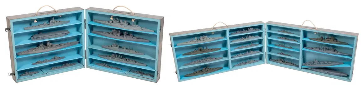
TWO CASED SETS OF WORLD WAR II-ERA U.S. NAVY RECOGNITION/TEACHING MODELS OF BRITISH AND FRENCH SHIPSEldred's4.7(419)See Sold PriceFeb 27, 2024
Nkisi Power Figure with Two Heads, Bakongo People, DR Congo/Zaire500 Gallery4.5(64)See Sold PriceFeb 27, 2024
MAGHREB. North Africa Morocco Algeria & Tunisia. JOHNSTON 1913 old antique mapJasper524.5(9.9k)See Sold PriceFeb 28, 2024
Afrique…Nord-Ouest' & 'Inde' by Meissas. N Africa India Singapore 1861 old mapJasper524.5(9.9k)See Sold PriceFeb 28, 2024
SOUTHERN AFRICA.Inset Ascension Is.; European colonies 1914;St Helena 1920 mapJasper524.5(9.9k)See Sold PriceFeb 28, 2024