Sayer (Robert) - A New Map of the World in Twolarge world map charting the circumnavigatory voyages of Dampier and Anson, with inset hemispheres of the poles to upper corners, and of the solstices in the lower, extensive text panels around and beSee Sold Price
Sayer (Robert) - A New Map of the World in Twolarge world map charting the circumnavigatory voyages of Dampier and Anson, with inset hemispheres of the poles to upper corners, and of the solstices in the lower, extensive text panels around and beSee Sold Price
A New and Complete Map of Scotland, And islands theretoIn A General Atlas Published by Robert Sayer, London, 1786-88 BT-263 a: 59.5 cm x 100.5 cm; BT-263 b: 59.5 cm x 100.5 cm Assembled: 119 cm x 100.5 cm Watermarked paper. Original color (shire boundarieSee Sold Price
A New and Complete Map of Scotland,Published by Robert Sayer, London, [1786-88]Assembled: 119 cm x 100.5 cmWatermarked paper. Original color (shire boundaries). Upper sheet has repair at a horizontal fold, as well as some frayed spotsSee Sold Price
SoldRobert Sayer Map, 1790Robert Sayer, "A New General Chart of the West Indies from the Latest Marine Journals and Surveys...", London, 1790, hand-colored in outline, printed on two separate sheets, very detailed large-formatSee Sold Price
SoldRobert Sayer Map, 1790Robert Sayer, "A New General Chart of the West Indies from the Latest Marine Journals and Surveys...", London, 1790, hand-colored in outline, printed on two separate sheets, very detailed large-formatSee Sold Price
SoldDunn, A Chart of the World, 1774[World]. Samuel Dunn. A Chart Of the World, According to Mercator's Projection Wherein are shewn the Latest Discoveries. Lon: Robert Sayer, 1774. Copper engraved double-page map from A New Atlas of thSee Sold Price
The East Indies, with the Roads, By Thomas Jefferys,Published by Robert Sayer, London, 1768 “To the Directors of the Honble East India Company, Thos Jefferys humbly Dedicates this Map.” a 53.5 cm x 138 cm b 55 cm x 138 cm Assembled: 108 cmSee Sold Price
SoldSayer (Robert) A New Map of North AmericaSayer (Robert) A New Map of North America with the West India Islands according to the Preliminary Articles of Peace Signed at Versailles, 20 Jan, 1783,wherein are particularly Distinguished TSee Sold Price
SoldSayer (Robert) - A New Map of the Whole Continent ofNorth and South America, with inset map of the Baffin and Hudson Bays, large decorative title cartouche, engraved map with original outline hand-colouring, cartouche uncoloured, 1040 x 1180mm., verticSee Sold Price
SoldSayer (Robert) - A New Map of the Roads of Englandincluding the roads of northern France to Paris, with inset Continuation of the Roads of Scotland, upper right, title cartouche just below, engraved map with original hand-colouring in outline, 760 xSee Sold Price
SoldSayer (Robert) A New Map of the NorthernSayer (Robert) A New Map of the Northern States containing the Kingdoms of Sweden, Denmark, and Norway,Scandinavia, extending to the western regions of Russia and eastern Europe, engraved mapSee Sold Price
Sayer (Robert) - A New Map of the Whole Continent ofNorth and South America, with inset map of the Baffin and Hudson Bays, large decorative title cartouche, engraved map with original outline hand-colouring, cartouche uncoloured, 1040 x 1180mm., verticSee Sold Price
Sayer. New Map of North America & West IndiesSayer (Robert) A New Map of North America with the West India Islands according to the Preliminary Articles of Peace Signed at Versailles, 20 Jan, 1783,wherein are particularly Distinguished TSee Sold Price
Sold(CANADA.) Sayer, Robert. A New and Correct Map(CANADA.) Sayer, Robert. A New and Correct Map of the British Colonies in North America. Double-page engraved map, 500x680 mm, wide margins; hand-colored in outline; browned along the fold, other scatSee Sold Price
SoldMORDEN, ROBERT. A New Map of ye World.MORDEN, ROBERT. A New Map of ye World. Miniature engraved double-hemisphere world map showing California as an island and with allegories of the four seasons represented in the corner spandrels. 6x7&#See Sold Price
SoldWalton (Robert) A New Map Of The World[Walton (Robert)] Publisher. A New And Accurat Map Of The World, twin-hemisphere map of the world with ships and sea monsters, with vignette scenes depicting the four elements in female form,See Sold Price
Robert Sayer - A New Map Of The Whole Continent OfRobert Sayer - A New Map Of The Whole Continent Of America (southern Section), 1786 Size: 36 X 16 In. - This Is A Gallery Stretched Giclee Print On Canvas. The Piece Was Printed On High Quality ArtistSee Sold Price
ROBERT SAYER - A NEW MAP OF THE WHOLE CONTINENT ORobert Sayer - A New Map Of The Whole Continent Of America (Southern Section), 1786 - Giclée On Canvas - 44 X 19 5/8 In. A Giclée Print Is The Highest Quality Print Available Today. Because There IsSee Sold Price
ROBERT SAYER - A NEW MAP OF THE WHOLE CONTINENT OFRobert Sayer - A New Map Of The Whole Continent Of America (southern Section), 1786 - 40 X 17 3/4 In. - This Giclée Print Is Gallery Stretched And Ready To Hang Or Lean Against A Wall, Or Display OnSee Sold Price
ROBERT SAYER - A NEW MAP OF THE WHOLE CONTINENT OFRobert Sayer - A New Map Of The Whole Continent Of America (southern Section), 1786 - 40 X 17 3/4 In. - This Giclée Print Is Gallery Stretched And Ready To Hang Or Lean Against A Wall, Or Display OnSee Sold Price
ROBERT SAYER -A NEW MAP OF THE WHOLE CONTINENT OFRobert Sayer -a New Map Of The Whole Continent Of America (southern Section), 1786 - Giclée On Canvas -40 X 17 3/4 In. - A Giclée Print Is The Highest Quality Print Available Today. Because There IsSee Sold Price
ROBERT SAYER - A NEW MAP OF THE WHOLE CONTINENT OFRobert Sayer - A New Map Of The Whole Continent Of America (southern Section), 1786 - 36 X 16 In. - Giclée Print - Gallery Stretched - Ready to hang.See Sold Price
SoldA NEW MAP OF THE WHOLE CONTINENT OF AMERICA (SOUTHERNRobert Sayer - A New Map Of The Whole Continent Of America (southern Section), 1786 - 40 X 17 3/4 In. - This Giclée Print Is Gallery Stretched And Ready To HangSee Sold Price
LATE 17TH C. FRENCH MAP OF THE NEW WORLD BY ALEXIS-HUBERT JAILLOT (1632-1712)Thomaston Place Auction Galleries4.4(393)See Sold PriceFeb 24, 2024
NICOLAES VISSCHER (NETHERLANDS, 1618-1709) MAP OF THE NEW WORLDThomaston Place Auction Galleries4.4(393)See Sold PriceFeb 24, 2024
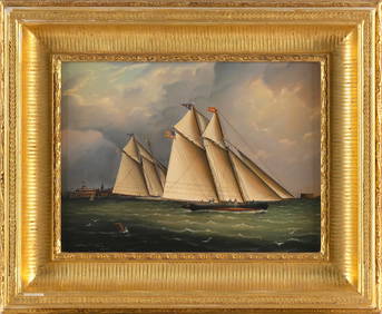
WILLIAM ROBERT DAVIS (Massachusetts, 1952-), Two New York Yacht Club yachts racing off CastleEldred's4.7(419)See Sold PriceFeb 28, 2024
Portfolio of 15 County Maps by Robert Morden (English 1650-1703)Nadeau's Auction Gallery4.7(409)See Sold PriceFeb 24, 2024
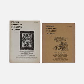
Hawk's Well Press, Jerome Rothenberg, Poems from the Floating World, Two VolumesCatalog Projects4.5(60)See Sold PriceFeb 28, 2024
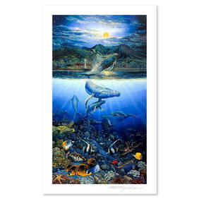
Robert Lyn Nelson, "Two Worlds" Limited Edition Mixed Media, Numbered and Hand Signed with Letter ofRobinhood Auctions4.7(794)See Sold PriceFeb 25, 2024
Two Hand-Colored 19th Century Maps of New Orleans and Louisiana, Larger- H.- 12 1/2 in., W.- 15 1/2Crescent City Auction Gallery4.3(231)See Sold PriceMar 08, 2024
Blackie (Pub) 1882 Folio Map. World on Mercators ProjectionAlbion Auctions4.7(341)See Sold PriceMar 01, 2024
Robert de Vaugondy - Map of Canada - Mer de l' Ouest or Sea of the West and a Northwest PassageProverde Auctions4.3(3)See Sold PriceFeb 28, 2024
Jules Verne, L'Archipel en Feu, Au Steamer Red MacaronLion and Unicorn4.8(1.9k)See Sold PriceMar 10, 2024