ATLAS of ANTIENT GEOGRAPHY by SAMUEL BUTLER 1843John McInnis Auctioneers,LLC4.6(502)See Sold PriceFeb 24, 2024
18TH C. ANTIQUE MAP: FRENCH & INDIAN WAR, FRAMEDThomaston Place Auction Galleries4.4(386)See Sold PriceFeb 24, 2024
Rand McNally Railroad Map Cabinet w/ 21 Railroad MapsRail & Road Auctions4.6(165)See Sold PriceMar 08, 2024
Keith Haring - Ink on New York Map, Best Buddies, Inscribed, Signed, and DatedSapphire Auction Gallery4(67)See Sold PriceMar 02, 2024
LATE 17TH C. FRENCH MAP OF THE NEW WORLD BY ALEXIS-HUBERT JAILLOT (1632-1712)Thomaston Place Auction Galleries4.4(386)See Sold PriceFeb 24, 2024
Central Railroad of New Jersey Map of Sandy Hook Route-ca. 1903JM Hobby Supply and Railroad Artifact Auctions4.4(126)See Sold PriceFeb 24, 2024
Lot of Six Mixed Atlas Box Cars-HO Scale-New in BoxJM Hobby Supply and Railroad Artifact Auctions4.4(126)See Sold PriceFeb 25, 2024
Rand McNally/Santa Fe Railroad Map of Iowa-1912JM Hobby Supply and Railroad Artifact Auctions4.4(126)See Sold PriceFeb 24, 2024
NICOLAES VISSCHER (NETHERLANDS, 1618-1709) MAP OF THE NEW WORLDThomaston Place Auction Galleries4.4(386)See Sold PriceFeb 24, 2024
17TH C. WORLD MAP BY NICOLAES VISSCHER (NETHERLANDS, 1618-1709)Thomaston Place Auction Galleries4.4(386)See Sold PriceFeb 24, 2024
Lot of Six Mixed Atlas Cabooses-HO Scale-New in BoxJM Hobby Supply and Railroad Artifact Auctions4.4(126)See Sold PriceFeb 25, 2024
SoldJohnston: Map of the Netherlands Belgium LuxemburgMap of Netherlands, Belgium and Luxemburg. The Cabinet Atlas of the World. Johnston, Alexander Keith. This plate: Netherlands, Belgium and Luxemburg. Edinburgh, W. & A.K. Johnston, 1878. Sheet size: 1See Sold Price
Sold1720 Homann Map of Netherlands, Belgium and LuxemburgReserve Reduced! Map Title/Content: 1720 Homann Map of Netherlands, Belgium and Luxemburg -- Tabula Generalis Totius Belgii qua Provinciae XVII. Infer. Germaniae olim sub S.R.I. Circulo Burgundiae…See Sold Price
1730 antique MAP of GERMANY Netherlands Belgium Luxemburg 18th CENTURYNetherlands, Belgium, Luxemburg Tabula generalis totius Belgii qua Provinciae XVII Infer. Germania olim sub S.R.I. Vircula Burgundiae by Homann, Johann Baptist, 1663-1724 Nuremberg, 1730 Size 20.5 bySee Sold Price
1730 antique MAP of GERMANY Netherlands Belgium Luxemburg 18th CENTURYNetherlands, Belgium, Luxemburg Tabula generalis totius Belgii qua Provinciae XVII Infer. Germania olim sub S.R.I. Vircula Burgundiae by Homann, Johann Baptist, 1663-1724 Nuremberg, 1730 Size 20.5 bySee Sold Price
1730 antique MAP of GERMANY Netherlands Belgium Luxemburg 18th CENTURYNetherlands, Belgium, Luxemburg Tabula generalis totius Belgii qua Provinciae XVII Infer. Germania olim sub S.R.I. Vircula Burgundiae by Homann, Johann Baptist, 1663-1724 Nuremberg, 1730 Size 20.5 bySee Sold Price
1730 antique MAP of GERMANY Netherlands Belgium Luxemburg 18th CENTURYNetherlands, Belgium, Luxemburg Tabula generalis totius Belgii qua Provinciae XVII Infer. Germania olim sub S.R.I. Vircula Burgundiae by Homann, Johann Baptist, 1663-1724 Nuremberg, 1730 Size 20.5 bySee Sold Price
1730 antique MAP of GERMANY Netherlands Belgium Luxemburg 18th CENTURYNetherlands, Belgium, Luxemburg Tabula generalis totius Belgii qua Provinciae XVII Infer. Germania olim sub S.R.I. Vircula Burgundiae by Homann, Johann Baptist, 1663-1724 Nuremberg, 1730 Size 20.5 bySee Sold Price
SoldMap of The Netherlands, Belgium, and LuxemburgMap of The Netherlands, Belgium, and Luxemburg Maker: Rand, McNally & Co. Date: 1898 From New Standard Atlas of the World Indexed Size: 15 x 21 inches No Reserve: This lot starts at $1 and has no reseSee Sold Price
Rand McNally Map of the Netherlands, Belgium, andRand McNally (Fl. 1870-1920's). Map of the Netherlands, Belgium, and Luxemburg. Lithograhped map with hand color from Rand, McNally & Co's Indexed Atlas of the World. Chicago: Rand McNally, 1895. 21 3See Sold Price
SoldGross, Alexander 1920 Lot of 8 Large European MapsIncl Bulgaria, Italy - South, Balkan States, Kindom of Serbs, Croats & Slovenes (Yugo-Slavia) South East Russia, The Netherlands, Belgium/Luxemburg, and Switzerland. Large Lithograph Maps Published 19See Sold Price
Gross, Alexander 1920 Lot of 8 Large European MapsIncl Bulgaria, Italy - South, Balkan States, Kindom of Serbs, Croats & Slovenes (Yugo-Slavia) South East Russia, The Netherlands, Belgium/Luxemburg, and Switzerland. Large Lithograph Maps Published 19See Sold Price
Belgium, Netherlands & Luxembourg. Benelux. Large 50x60cm. JOHNSTON 1879 mapTITLE/CONTENT OF MAP: 'Belgium and The Netherlands' DATE PRINTED: 1879 IMAGE SIZE: Approx 60.5 x 48.0cm, 23.75 x 18.75 inches (Large); Please note that this is a folding map. TYPE: Large, folio antiquSee Sold Price
SoldMillar: Antique Map Netherlands Belgium Luxenburg, 1768Title/Content of Map: 1768 Millar Map of Netherlands, Belgium, Luxenburg -- A New and Accurate Map of the Seven United Provinces Imcluding the Dutch Netherlands & e. Date Printed: 1768 Cartographer: GSee Sold Price
SoldBarclay, James 1809 Antique Map. Netherlands & Belgium"The Seven United Provinces, with The Dutch Possessions in Flanders, Brabant and Limburg" Outline Hand Coloured Copper Engraved Map Published 1809, Leeds for "Barclay's Complete and Universal DictionaSee Sold Price
Tanner: Antique Map of Netherlands & Belgium, 1843Title/Content of Map: Netherlands & Belgium by Tanner Date Printed: 1843 Cartographer: H.C. Tanner Material/Medium: Paper Size: 17" x 14" Hand colored engraved Map based on the work of H.C. Tanner froSee Sold Price
Seutter: Antique Map of Netherlands & Belgium, 1740Title/Content of Map: Netherlands & Belgium or the 17 provinces Date Printed: c1740 Cartographer: Matthaus Seutter Material/Medium: Paper Size: 19 1/2" x 23 2/3" Original hand colored copperplate engrSee Sold Price
Netherlands & Belgium by TannerTitle/Content of Map: Netherlands & Belgium by Tanner Date Printed: 1843 Cartographer: Tanner Material/Medium: Paper Provenance: New York Please note that this lot has a confidential reserve. When youSee Sold Price
Netherlands & BelgiumTitle/Content of Map: Netherlands & Belgium Date Printed: 1843 Cartographer: Tanner Material/Medium: Paper Size: 14" x 17" Provenance: New York Please note that this lot has a confidential reserve. WhSee Sold Price
Tanner: Antique Map of Netherlands & Belgium, 1843Title/Content of Map: Netherlands & Belgium by Tanner Date Printed: 1843 Material/Medium: Paper Provenance: New York Please note that this lot has a confidential reserve. When you leave a bid in advanSee Sold Price
SoldDesnos/de la Tour: Antique Map of Netherlands & BelgiumTITLE/CONTENT OF MAP: 'Les Pays Bas François. Autrichiens, et Hollandois, divisés en Provinces Civiles et Ecclésiastiques. à Paris. Chez le Sr. Desnos. Ingenieur Géographe pour les Globes et Sph�See Sold Price
de la Tour: Antique Map of Netherlands & Belgium, 1771TITLE/CONTENT OF MAP: 'Les Pays Bas François. Autrichiens, et Hollandois, divisés en Provinces Civiles et Ecclésiastiques. à Paris. Chez le Sr. Desnos. Ingenieur Géographe pour les Globes et Sph�See Sold Price
SoldColton: Antique Map of Netherlands, Belgium, 1859Netherlands, Belgium & Luxembourg with insterst of Brussels & Amsterdam 1859 H.J. Colton 17 1/2" x 15" Hand colored and engraved. Published in New York in Colton's 'General Atlas'. Please note that thSee Sold Price
Millar Map of Netherlands, Belgium, Luxembourg 1768Map: 1768 Millar Map of Netherlands, Belgium, Luxembourg -- A New and Accurate Map of the Seven United Provinces Including the Dutch Netherlands & e. Cartographer: G Millar Year / Place: 1768 (pencileSee Sold Price
Map of Netherlands, Belgium. 1839.Print of steel engraving. Author unknown.Engraved by G. Boynton.Notes: Entered according to act of Congrass on the 9th day of March by S. G. Goodrich of Mass.From „The second book of History, includSee Sold Price
NICOLAES VISSCHER (NETHERLANDS, 1618-1709) MAP OF THE NEW WORLDThomaston Place Auction Galleries4.4(386)See Sold PriceFeb 24, 2024
WILLEM JANSZOON BLAEU (NETHERLANDS, 1571-1638) MAP OF UMBRIAThomaston Place Auction Galleries4.4(386)See Sold PriceFeb 24, 2024
Large Collection of Various World Currency - CoinsPremier Auction Galleries4.3(329)See Sold PriceMar 09, 2024
NORTH WEST AFRICA Maghreb Morocco Tunisia Algeria JOHNSTON 1897 old mapJasper524.5(9.8k)See Sold PriceFeb 28, 2024
AFRICA NW & SOUTH. Maghreb. Cape Colony electoral divisions. JOHNSTON 1906 mapJasper524.5(9.8k)See Sold PriceFeb 28, 2024
COLONIAL CENTRAL AFRICA. Kenya Tanzania Belgian Congo Angola. JOHNSTON 1912 mapJasper524.5(9.8k)See Sold PriceFeb 28, 2024
COLONIAL CENTRAL AFRICA. Kenya Tanzania Belgian Congo Angola. JOHNSTON 1913 mapJasper524.5(9.8k)See Sold PriceFeb 28, 2024
COLONIAL/TRIBAL AFRICA British East/Central/South Africa JOHNSTON 1892 old mapJasper524.5(9.8k)See Sold PriceFeb 28, 2024
Set of 4 Maps - Netherlands - Seven United Provinces - Germany - Sweden, Denmark, Norway, FinlandProverde Auctions4.3(3)See Sold PriceFeb 28, 2024
Set of 3 Maps - Netherlands - Belgien - Switzerland - J. BarlowProverde Auctions4.3(3)See Sold PriceFeb 28, 2024
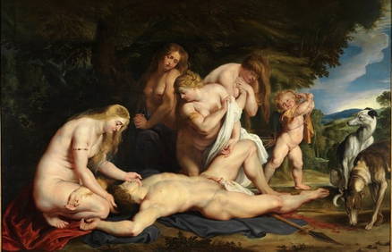
Sir Peter Paul Rubens - The Death of Adonis (with Venus, Cupid, and the Three GrFederal Assets Auctioneers4.4(411)See Sold PriceFeb 24, 2024
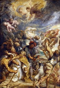
Sir Peter Paul Rubens - The Martyrdom of Saint LivinusFederal Assets Auctioneers4.4(411)See Sold PriceFeb 27, 2024
The Last Coins of Europe 12 Coins Set - Spain, Portugal, France, Italy, Ireland, Belgium, Luxemburg,Andrew's Coin & Jewelry4.5(209)See Sold PriceMar 07, 2024