ATLAS of ANTIENT GEOGRAPHY by SAMUEL BUTLER 1843John McInnis Auctioneers,LLC4.5(505)See Sold PriceFeb 24, 2024
18TH C. ANTIQUE MAP: FRENCH & INDIAN WAR, FRAMEDThomaston Place Auction Galleries4.4(393)See Sold PriceFeb 24, 2024
Rand McNally Railroad Map Cabinet w/ 21 Railroad MapsRail & Road Auctions4.6(165)See Sold PriceMar 08, 2024
Keith Haring - Ink on New York Map, Best Buddies, Inscribed, Signed, and DatedSapphire Auction Gallery4.1(67)See Sold PriceMar 02, 2024
LATE 17TH C. FRENCH MAP OF THE NEW WORLD BY ALEXIS-HUBERT JAILLOT (1632-1712)Thomaston Place Auction Galleries4.4(393)See Sold PriceFeb 24, 2024
Central Railroad of New Jersey Map of Sandy Hook Route-ca. 1903JM Hobby Supply and Railroad Artifact Auctions4.4(127)See Sold PriceFeb 24, 2024
Lot of Six Mixed Atlas Box Cars-HO Scale-New in BoxJM Hobby Supply and Railroad Artifact Auctions4.4(127)See Sold PriceFeb 25, 2024
Rand McNally/Santa Fe Railroad Map of Iowa-1912JM Hobby Supply and Railroad Artifact Auctions4.4(127)See Sold PriceFeb 24, 2024
NICOLAES VISSCHER (NETHERLANDS, 1618-1709) MAP OF THE NEW WORLDThomaston Place Auction Galleries4.4(393)See Sold PriceFeb 24, 2024
17TH C. WORLD MAP BY NICOLAES VISSCHER (NETHERLANDS, 1618-1709)Thomaston Place Auction Galleries4.4(393)See Sold PriceFeb 24, 2024
Lot of Six Mixed Atlas Cabooses-HO Scale-New in BoxJM Hobby Supply and Railroad Artifact Auctions4.4(127)See Sold PriceFeb 25, 2024
Johnson’s map of New York and the Adjacent Cities,"c.Johnson’s map of New York and the Adjacent Cities,"c. 1860, by Johnson & Ward, H.- 18 in., W.- 27 in.See Sold Price
Pocket Map of ManhattanEdsall, D. A. & Co. (fl. c. 1877 - c. 1878). Citizens & Travelers Guide Map in to and from the City of New York and Adjacent Places. Lithographed Map. D. A. Edsall & Co., 1877. 26⅛" x 19��See Sold Price
Pocket Map of ManhattanEdsall, D. A. & Co. (fl. c. 1877 - c. 1878). Citizens & Travelers Guide Map in to and from the City of New York and Adjacent Places. (With Tiffany Ad). Lithographed Map. D. A. Edsall & Co., 1877. 26"See Sold Price
Map of New York & Adjacent Cities 1864Map: Map of New York and the Adjacent Cities Maker: Johnson & Ward, Colton, Joseph Hutchins Publishing: New York 1864 Size: 16 x 26 inches Colton plan reissued by Johnson with a different border PleasSee Sold Price
SoldMagnus's 1850 Litho of the 1728 Bradford Map NYCColonial AmericaMagnus’s 1850s Litho of the 1728 “Bradford Map” of New York City c. 1850, “A Plan of the City of New York from an Actual Survey,” By Charles Magnus, afterSee Sold Price
Johnson's Map of New York and Adjacent CitiesJohnson & Ward, Johnson, A.J., 1863, Double Folio – 15.30 H x 24.70 W Inches, City plan naming streets, squares, parks, railroads etc. Decorative border. Inset: continuation of N.Y.C. north. PleaseSee Sold Price
SoldJohnson's Map of New York and Adjacent Cities.Title: Johnson's Map of New York and Adjacent Cities. Date: 1862 Cartographer: Size: 15 X 24.8 Detailed city plan of streets, parks, principal buildings, railroads, etc. Shows Brooklyn and part of JerSee Sold Price
Johnson's Map of New York & the Adjacent Cities, 1862Map: Johnson's Map of New York and the Adjacent Cities Maker: Johnson and Ward, Alvin Jewett Johnson Date: 1862 Size: Double Folio, 14.5 inches high x 24.5 inches wide Map detailing districts separateSee Sold Price
Johnson's Map of New York and Adjacent CitiesTitle: Johnson's Map of New York and Adjacent Cities Publication Date: 1863 Cartographer: JOHNSON, A.J. Publisher: JOHNSON & WARD Dimensions: 15.3 X 24.7 Additional Information: 29. 30. City plan namiSee Sold Price
Johnson's Map of New York and Adjacent CitiesTitle: Johnson's Map of New York and Adjacent Cities Cartographer: JOHNSON, A.J. Publisher: JOHNSON & WARD Size: 15.3Height - 24.7Width 29. 30. City plan naming streets, squares, parks, railroads etc.See Sold Price
Johnson's Map of New York and Adjacent CitiesPublication Date: 1863 Title: Johnson's Map of New York and Adjacent Cities Cartographer: JOHNSON, A.J. Publisher: JOHNSON & WARD Height: 15.3 Width: 24.7 29. 30. City plan naming streets, squares, paSee Sold Price
GAYLORD WATSON -MAP OF NEW YORK AND ADJACENT CITIES,Gaylord Watson -map Of New York And Adjacent Cities, 1874 - Giclée On Canvas -31 1/4 X 40 In. - A Giclée Print Is The Highest Quality Print Available Today. Because There Is No Visible Dot Screen PaSee Sold Price
GAYLORD WATSON -MAP OF NEW YORK AND ADJACENT CITIES,Gaylord Watson -map Of New York And Adjacent Cities, 1874 - Giclée On Canvas -34 3/8 X 44 In. - A Giclée Print Is The Highest Quality Print Available Today. Because There Is No Visible Dot Screen PaSee Sold Price
GAYLORD WATSON - MAP OF NEW YORK AND ADJACENT CITGaylord Watson - Map Of New York And Adjacent Cities, 1874 - Giclée On Canvas - 31 1/4 X 40 In. A Giclée Print Is The Highest Quality Print Available Today. Because There Is No Visible Dot Screen PaSee Sold Price
GAYLORD WATSON"MAP OF NEW YORK AND ADJACENT CITIEThis Is A GAYLORD WATSON Giclee on CANVAS Titled "MAP OF NEW YORK AND ADJACENT CITIES, 1874"Measuring - 23 1/2 x 30 in.This Giclée is high-resolution and of the highest quality, has a color permanencSee Sold Price
Soldc 1730 Seutter Map: Novi Belgii, in America ...Historic Maps c. 1730 Historic Rare Earlier State of Seutter's Important American Northeast Map & New York City Restitutio View c. 1730 Hand-Colored Copper-Engraved Map titled, "Recens Edita totius NoSee Sold Price
SoldJohnson's Map of New York and the Adjacent Cities.Title: Johnson's Map of New York and the Adjacent Cities. Publication Date: 1866 Cartographer: JOHNSON, ALVIN JEWETT Publisher: JOHNSON AND WARD Size: 16Height - 26Width 29-30. Original coloring. BrowSee Sold Price
SoldJohnson's Map of New York and the Adjacent Cities.Title: Johnson's Map of New York and the Adjacent Cities. Publication Date: 1864 Cartographer: JOHNSON, ALVIN JEWETT Publisher: JOHNSON AND WARD Size: 16x26 Original coloring. 29-30. Browned, margin sSee Sold Price
SoldMap of New York and the Adjacent Cities.Title: Map of New York and the Adjacent Cities. Date: 1858 Cartographer: COLTON, JOSEPH HUTCHINS Size: 15.75 X 25 Browned. Margin spotted. Centerfold repaired. Please note that this lot has a confidenSee Sold Price
SoldJohnson's Map of New York and the Adjacent Cities.Title/Content of Map: Johnson's Map of New York and the Adjacent Cities. Date: 1866 Cartographer: JOHNSON, ALVIN JEWETT Size: 16X26 Original coloring. Damped with some loosening of sections. 4' X 5'+See Sold Price
SoldGrp: 9 Maps of New York City 18th-Early 20th c.Group of nine maps of New York City, dating from the 18th to early 20th century. By cartographers including John Montresor (1736-1799). Additionally includes a lovely 1704 map of the city featuring thSee Sold Price
SoldGrp: 10 Maps of New York City 18th-Early 20th c.Group of 18th to early 20th century maps of New York City. Multiple are 19th-20th c. reprints of 17th-18th c. maps. Includes a small census map of New York City from 1850 with populations of New YorkSee Sold Price
SoldGrp: 3 Maps of New York CityGroup of three maps of New York City. Includes Mark Tiddeman, "A Draught of New York from the Hook to New York Town," London: W. Mount & T. Page; "Map of New York and the Adjacent Cities," New York: JSee Sold Price
SoldTwo hand colored engraved double page large folio mapsTwo hand colored engraved double page large folio maps including The United States of America and Map of New York and the Adjacent Cities. 16 1/2" x 27" and 17 1/2" x 27" Provenance: Property from CSee Sold Price
Erie Railway Tourist Book/Magazine-1874JM Hobby Supply and Railroad Artifact Auctions4.4(127)See Sold PriceFeb 24, 2024
2nd Century Style Bronze Buddha-Himalayan- ProvenanceThe Buddha Gallery4.4(29)See Sold PriceMar 13, 2024
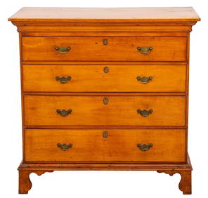
American Federal Period Maple Chest, Late 18th C.Auctions at Showplace4.6(740)See Sold PriceMar 03, 2024
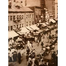
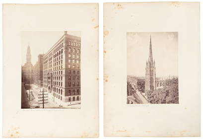
c1900 Street Scene, New York City's Lower East SideConnoisseur Auctions3.9(336)See Sold PriceFeb 24, 2024
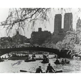
Historic New York City, Central Park Photo PrintConnoisseur Auctions3.9(336)See Sold PriceMar 02, 2024
Pair of The Gateway to a Continent Books - Grand Central Zone and 1939 World's FairRail & Road Auctions4.6(165)See Sold PriceMar 07, 2024
Johann Homann Hand-Colored Map Engraving, c. 1730Auctions at Showplace4.6(740)See Sold PriceMar 17, 2024
Willem Blaeu, Etc. 17th C. Antiquarian Maps, 2Auctions at Showplace4.6(740)See Sold PriceMar 17, 2024
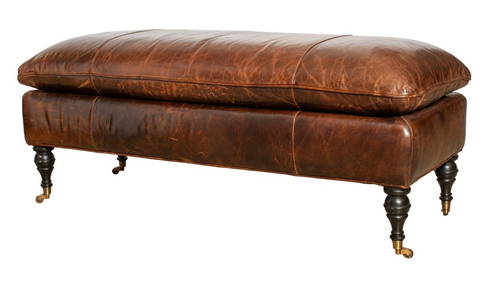
George Smith Attrib Brown Leather Bench, 20th C.Auctions at Showplace4.6(740)See Sold PriceMar 17, 2024
Herman Leonard (American, 1923-2010) Lena Horne, New York City, 1949Freeman's | Hindman4.4(1.6k)See Sold PriceMar 07, 2024
Graff, Washbourne and Dunn, Candlesticks, pairToomey & Co. Auctioneers4.7(392)See Sold PriceFeb 29, 2024
Black and white map of part of New York City (mostly Manhattan)Proverde Auctions4.3(3)See Sold PriceFeb 28, 2024
Laminated Unique Media New York City MapRapid Estate Liquidators and Auction Gallery4.5(1.1k)See Sold PriceFeb 29, 2024
Curtis Jere Style Mixed Media Cattail SculptureAuctions at Showplace4.6(740)See Sold PriceApr 16, 2024
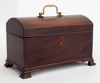
George III Mahogany Domed Lid Tea Caddy, 19th C.Auctions at Showplace4.6(740)See Sold PriceFeb 13, 2025