ATLAS of ANTIENT GEOGRAPHY by SAMUEL BUTLER 1843John McInnis Auctioneers,LLC4.6(502)See Sold PriceFeb 24, 2024
18TH C. ANTIQUE MAP: FRENCH & INDIAN WAR, FRAMEDThomaston Place Auction Galleries4.4(386)See Sold PriceFeb 24, 2024
Rand McNally Railroad Map Cabinet w/ 21 Railroad MapsRail & Road Auctions4.6(165)See Sold PriceMar 08, 2024
Keith Haring - Ink on New York Map, Best Buddies, Inscribed, Signed, and DatedSapphire Auction Gallery4(67)See Sold PriceMar 02, 2024
LATE 17TH C. FRENCH MAP OF THE NEW WORLD BY ALEXIS-HUBERT JAILLOT (1632-1712)Thomaston Place Auction Galleries4.4(386)See Sold PriceFeb 24, 2024
Central Railroad of New Jersey Map of Sandy Hook Route-ca. 1903JM Hobby Supply and Railroad Artifact Auctions4.4(126)See Sold PriceFeb 24, 2024
Lot of Six Mixed Atlas Box Cars-HO Scale-New in BoxJM Hobby Supply and Railroad Artifact Auctions4.4(126)See Sold PriceFeb 25, 2024
Rand McNally/Santa Fe Railroad Map of Iowa-1912JM Hobby Supply and Railroad Artifact Auctions4.4(126)See Sold PriceFeb 24, 2024
NICOLAES VISSCHER (NETHERLANDS, 1618-1709) MAP OF THE NEW WORLDThomaston Place Auction Galleries4.4(386)See Sold PriceFeb 24, 2024
17TH C. WORLD MAP BY NICOLAES VISSCHER (NETHERLANDS, 1618-1709)Thomaston Place Auction Galleries4.4(386)See Sold PriceFeb 24, 2024
Lot of Six Mixed Atlas Cabooses-HO Scale-New in BoxJM Hobby Supply and Railroad Artifact Auctions4.4(126)See Sold PriceFeb 25, 2024
Johnson's Map of New York and Adjacent CitiesJohnson & Ward, Johnson, A.J., 1863, Double Folio – 15.30 H x 24.70 W Inches, City plan naming streets, squares, parks, railroads etc. Decorative border. Inset: continuation of N.Y.C. north. PleaseSee Sold Price
SoldJohnson's Map of New York and Adjacent Cities.Title: Johnson's Map of New York and Adjacent Cities. Date: 1862 Cartographer: Size: 15 X 24.8 Detailed city plan of streets, parks, principal buildings, railroads, etc. Shows Brooklyn and part of JerSee Sold Price
Johnson's Map of New York & the Adjacent Cities, 1862Map: Johnson's Map of New York and the Adjacent Cities Maker: Johnson and Ward, Alvin Jewett Johnson Date: 1862 Size: Double Folio, 14.5 inches high x 24.5 inches wide Map detailing districts separateSee Sold Price
Johnson's Map of New York and Adjacent CitiesTitle: Johnson's Map of New York and Adjacent Cities Publication Date: 1863 Cartographer: JOHNSON, A.J. Publisher: JOHNSON & WARD Dimensions: 15.3 X 24.7 Additional Information: 29. 30. City plan namiSee Sold Price
Johnson's Map of New York and Adjacent CitiesTitle: Johnson's Map of New York and Adjacent Cities Cartographer: JOHNSON, A.J. Publisher: JOHNSON & WARD Size: 15.3Height - 24.7Width 29. 30. City plan naming streets, squares, parks, railroads etc.See Sold Price
Johnson's Map of New York and Adjacent CitiesPublication Date: 1863 Title: Johnson's Map of New York and Adjacent Cities Cartographer: JOHNSON, A.J. Publisher: JOHNSON & WARD Height: 15.3 Width: 24.7 29. 30. City plan naming streets, squares, paSee Sold Price
SoldJohnson's Map of New York and the Adjacent Cities.Title: Johnson's Map of New York and the Adjacent Cities. Publication Date: 1866 Cartographer: JOHNSON, ALVIN JEWETT Publisher: JOHNSON AND WARD Size: 16Height - 26Width 29-30. Original coloring. BrowSee Sold Price
SoldJohnson's Map of New York and the Adjacent Cities.Title: Johnson's Map of New York and the Adjacent Cities. Publication Date: 1864 Cartographer: JOHNSON, ALVIN JEWETT Publisher: JOHNSON AND WARD Size: 16x26 Original coloring. 29-30. Browned, margin sSee Sold Price
SoldJohnson's Map of New York and the Adjacent Cities.Title/Content of Map: Johnson's Map of New York and the Adjacent Cities. Date: 1866 Cartographer: JOHNSON, ALVIN JEWETT Size: 16X26 Original coloring. Damped with some loosening of sections. 4' X 5'+See Sold Price
Johnson's Map of New York and the Adjacent Cities.Title: Johnson's Map of New York and the Adjacent Cities. Publication Date: 1864 Cartographer: JOHNSON, ALVIN JEWETT Publisher: JOHNSON AND WARD Size: 16 x 26 Description: Original coloring. Inset ofSee Sold Price
Johnson’s map of New York and the Adjacent Cities,"c.Johnson’s map of New York and the Adjacent Cities,"c. 1860, by Johnson & Ward, H.- 18 in., W.- 27 in.See Sold Price
Map of New York & Adjacent Cities 1864Map: Map of New York and the Adjacent Cities Maker: Johnson & Ward, Colton, Joseph Hutchins Publishing: New York 1864 Size: 16 x 26 inches Colton plan reissued by Johnson with a different border PleasSee Sold Price
Map of New York and the Adjacent Cities.Publication Date: 1864 Title: Map of New York and the Adjacent Cities. Cartographer: COLTON, JOSEPH HUTCHINS Height: 16Width: 26 Colton plan reissued by Johnson with a different border. The plan is idSee Sold Price
SoldJOHNSON'S MAP OF NEW YORK CITYOriginal hand-colored engraved map with center fold, as published. Dimensions: (Frame) H 21.25" x W 30", (Sight) H 17.25" x W 26" Condition: Good, strong color. The slightest of age toning.See Sold Price
SoldJohnson: Antique Map of New York City, 1866Title/Content of Map: 1866 Johnson Map of New York City -- Johnson's New York and Brooklyn Date Printed: 1866, New York Cartographer: A Johnson Size: 22.8 x 16.3 in Condition: Very good. Age toning noSee Sold Price
Gaylord Watson - Map Of New York And Adjacent Cities,Gaylord Watson - Map Of New York And Adjacent Cities, 1874 Size: 28 1/8 X 36 In. - This Is A Gallery Stretched Giclee Print On Canvas. The Piece Was Printed On High Quality Artist Grade 350 Gsm, Acid-See Sold Price
GAYLORD WATSON -MAP OF NEW YORK AND ADJACENT CITIES,Gaylord Watson -map Of New York And Adjacent Cities, 1874 - Giclée On Canvas -31 1/4 X 40 In. - A Giclée Print Is The Highest Quality Print Available Today. Because There Is No Visible Dot Screen PaSee Sold Price
GAYLORD WATSON -MAP OF NEW YORK AND ADJACENT CITIES,Gaylord Watson -map Of New York And Adjacent Cities, 1874 - Giclée On Canvas -34 3/8 X 44 In. - A Giclée Print Is The Highest Quality Print Available Today. Because There Is No Visible Dot Screen PaSee Sold Price
Gaylord Watson - Map Of New York And Adjacent Cities,Gaylord Watson - Map Of New York And Adjacent Cities, 1874 Size: 34 3/8 X 44 In. - This Is A Gallery Stretched Giclee Print On Canvas. The Piece Was Printed On High Quality Artist Grade 350 Gsm, Acid-See Sold Price
GAYLORD WATSON -MAP OF NEW YORK AND ADJACENT CITIES,Gaylord Watson -map Of New York And Adjacent Cities, 1874 - Giclée On Canvas -31 1/4 X 40 In. - A Giclée Print Is The Highest Quality Print Available Today. Because There Is No Visible Dot Screen PaSee Sold Price
GAYLORD WATSON - MAP OF NEW YORK AND ADJACENT CITGaylord Watson - Map Of New York And Adjacent Cities, 1874 - Giclée On Canvas - 31 1/4 X 40 In. A Giclée Print Is The Highest Quality Print Available Today. Because There Is No Visible Dot Screen PaSee Sold Price
GAYLORD WATSON"MAP OF NEW YORK AND ADJACENT CITIEThis Is A GAYLORD WATSON Giclee on CANVAS Titled "MAP OF NEW YORK AND ADJACENT CITIES, 1874"Measuring - 23 1/2 x 30 in.This Giclée is high-resolution and of the highest quality, has a color permanencSee Sold Price
SoldJohnson: Antique New York State Map, 1865Title/Content of Map: 1865 Johnson's New York State Map -- Johnson's New York City, Brooklyn, Jersey City, Hoboken, Etc Date Printed: 1865 New York Cartographer: A Johnson & Co. Size: 16.8 x 25 This iSee Sold Price
SoldMap of New York and the Adjacent Cities.Title: Map of New York and the Adjacent Cities. Date: 1858 Cartographer: COLTON, JOSEPH HUTCHINS Size: 15.75 X 25 Browned. Margin spotted. Centerfold repaired. Please note that this lot has a confidenSee Sold Price
Crams Railroad Map of New York-1881JM Hobby Supply and Railroad Artifact Auctions4.4(126)See Sold PriceFeb 24, 2024
Erie Railway Tourist Book/Magazine-1874JM Hobby Supply and Railroad Artifact Auctions4.4(126)See Sold PriceFeb 24, 2024
George Hayward - Map of the City of New York 1854Dane Fine Art Auctions4.4(494)See Sold PriceMar 07, 2024
1872 Holy BIBLE & Hitchcock Analysis Gruden Concordance Theology MAPS Holy LandSchilb Antiquarian Rare Books4.8(421)See Sold PriceMar 31, 2024
Pair of The Gateway to a Continent Books - Grand Central Zone and 1939 World's FairRail & Road Auctions4.6(165)See Sold PriceMar 07, 2024
ANDREW RAYMOND JANSON OIL ON BOARD ADIRONDACKSCharleston Estate Services Ltd.4.5(58)See Sold PriceMar 03, 2024
Johann Homann Hand-Colored Map Engraving, c. 1730Auctions at Showplace4.5(726)See Sold PriceMar 17, 2024
Willem Blaeu, Etc. 17th C. Antiquarian Maps, 2Auctions at Showplace4.5(726)See Sold PriceMar 17, 2024
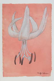
Buffie Johnson (New York, 1912-2006), "Untitled (Lilium cernuum)," 20th c., H.- 14 1/2 in., W.- 11Crescent City Auction Gallery4.3(229)See Sold PriceMar 08, 2024
Alfred Salzman, Etc. JNF Tin Tzedakah Boxes, 3Auctions at Showplace4.5(726)See Sold PriceApr 07, 2024
Georg Bockler Map of Ancient Jerulsaem EtchingAuctions at Showplace4.5(726)See Sold PriceApr 07, 2024
Four Vintage The Outlook Magazines New York ARapid Estate Liquidators and Auction Gallery4.5(1.1k)See Sold PriceFeb 26, 2024
Black and white map of part of New York City (mostly Manhattan)Proverde Auctions4.3(3)See Sold PriceFeb 28, 2024
Laminated Unique Media New York City MapRapid Estate Liquidators and Auction Gallery4.5(1.1k)See Sold PriceFeb 29, 2024