SoldJOHN SENEX- MAP OF THE SOLAR SYSTEM "A Scheme of tJOHN SENEX- MAP OF THE SOLAR SYSTEM "A Scheme of the Solar System with the Orbits of the Planets and Comets belonging thereto." 27"x 24", circa 1712See Sold Price
MAP, Solar System, SenexImpressive Chart Popularizing Isaac Newton's Ideas. Solar System. John Senex, A Scheme of the Solar System with the Orbits of the Planets and Comets Belonging Thereto, Describ'd from Dr. Halley's AccuSee Sold Price
Sold(CELESTIAL.) Whiston, William; and Senex, John. A(CELESTIAL.) Whiston, William; and Senex, John. A Scheme of the Solar System with the Orbits of the Planets and Comets Belonging Thereto, Described from Dr. Halley's Accurate Table of Comets... FoundeSee Sold Price
SoldPeacock (William, publisher) A CompendiousPeacock (William, publisher) A Compendious Geographical Dictionary,1 engraved folding plate of the Solar System and 13 folding maps hand-coloured in outline, ink inscriptions to Henry John SelSee Sold Price
SoldBlack & Bartholomew 1882 Astronomy Celestial Map"The Solar System" and "Theory of the Seasons" Steel Engraved Map Published 1882 by A. & C. Black, Edinburgh for "Blacks General Atlas of the World" Engraved by John Bartholomew. Paper Size: 17.5 x 12See Sold Price
1721 John Senex Map of the WorldItem: 1721 John Senex Map of the World Description: John Senex Map of the World Dimensions: 17 x 21.5 in Please note that this lot has a confidential reserve. When you leave a bid in advance of the auSee Sold Price
SoldJOHN SENEX MAP OF LOUISIANA AND RIVER MISSISSIPI,Map of French Louisiana, reportedly derived from Delisle's 1718 map. Lists native settlements and areas of 'Wandering Indians and Man-eaters,' Promiscuous Nations,' and 'Nations destroyed.' Roads andSee Sold Price
SoldJohn Senex Map Of The MississippiJohn Senex colored engraved map. A Map of Louisiana And Of The River Mississippi. Marked lower right: This map of the Mississippi is most humbly inscribed to William Law. Unframed. 20-1/2 in x 24 in.See Sold Price
SoldStieler, Adolf 1879 Astronomy Map. Solar System"Planeten-System der Sonne" Steel Engraved Map Published 1879, Gotha, Germany for "Hand-Atlas über alle Theile der Erde und über das Weltgebäude" by Adolf Stieler. Centre fold as published. Paper SSee Sold Price
SoldJohn Senex Map of North AmericaBritish, 18th century, black and white printing with minimal colored highlights, decorative cartouche in upper left, 40 x 27 in.; framed 44 x 31-1/2 in.See Sold Price
SoldTimes Atlas 1895 Celestial Map. Solar System, MoonLithograph Map Published 1895, London for "The Times Atlas" Paper Size: 16 x 10.5 inch (41 x 27cm) Good ConditionSee Sold Price
SoldJohn Senex Map of North AmericaBritish, 1710, North America Corrected From The Observations Communicated To The Royal Society, decorative cartouche in upper left, engraving with hand colored highlights, on laid paper, 40 x 27 in.;See Sold Price
SoldJohn Senex Map of North and South America 1719-17John Senex (1678–1740), "A New Map of America from the Latest Observations," London, ca. 1719-1721. Hand colored copperplate engraved map of North and South America, from Senex's "New General ASee Sold Price
SoldJohn Senex, MapJohn Senex, "A Map of Louisiana and of the River Mississipi", London, 1721, famously plagiarized from Delisle's original 1718 map, mounted on board, framed, 19 in. x 23 in.,See Sold Price
SoldAstronomy C1880 Hand Col Celstial Map. Solar SystemHand Coloured Woodblock Published C1868-81 by William Mackenzie, London for "The National Encyclopedia: A dictionary of Universal Knowledge" Centre Fold as issued. Paper Size: 11.5 x 9 inch (29 x 23cmSee Sold Price
SoldEncyclo. Metropolitana 1822 Celestial Map. Solar SystemCopper Engraved Map Published 1817-45, London for "Encyclopaedia Metropolitana" by Samuel Taylor Coleridge el al. Engraved by Neele & Son. Paper Size: 10.5 x 8 inch (27 x 21cm) Very minor water stainSee Sold Price
SoldJOHN SENEX MAP OF INDIA & CHINA dated 1720Borders and boundaries hand colored on laid paper. 19 1/2 x 23 inches (plate). framed 23 x 27 inches (overall)See Sold Price
John Senex Map of EuropeA New Map of Europe From the Latest Observations, "Inscribed to the Honorable Samuel Molyneux, Esq., Secretary to His R.H. the Prince" by John Senex, undated, circa 1720, double page hand-colored engrSee Sold Price
SoldMAP, Solar System, DoppelmayrSolar System. Doppelmayr/Homann, Systema Solare et Planetarium ex Hypothesi Copernicana Secundum Elegantissimas Illustrissimi Quondam Hugenii Deductiones Novissime Collectum & Exhibitum, 1742 (circa).See Sold Price
SoldJohn Senex, "Map of Louisiana", 1721John Senex, "A Map of Louisiana and the River Mississippi", 1721, London, copper-plate engraved map, laid paper, watermarked with a fleur-de-lis and "HD", the map with interesting nomenclature of "ProSee Sold Price
SoldJohn Senex Map of ScandinaviaScandinavie and Its Confines in Which are the Kingdom of Sweden, Norway & cc, "Most Humbly Inscribed to His Grace the Duke of Shandou", 1719, hand-colored engraving on-laid paper, 23 x 20 in.; modernSee Sold Price
SoldJOHN SENEX "Map of España and Portugal"“A Correct Map of SPAIN & PORTUGAL According to the newest Observations….”. London, 1708. Rare map of the Peninsula and the Balearic Islands, delineated by Price and engraved on twoSee Sold Price
JOHN SENEX MAP OF ASIASENEX, John, (English, 1678-1740): Hand tinted map of Asia, titled "Asia, Corrected from the Observations communicated to the Royal Society at London and the Royal Academy at Paris" in cartouche upperSee Sold Price
JOHN SENEX (1678 - 1740) Map of Ireland [1728] 96 xJOHN SENEX (1678 - 1740) Map of Ireland [1728] 96 x 66cm This is the second edition of John Senex map of Ireland in which the Maxwell imprint has been removed and the address is now 'The Globe againstSee Sold Price
Crams Map of North Dakota-Complete Railroad System and County Map-1907JM Hobby Supply and Railroad Artifact Auctions4.4(127)See Sold PriceFeb 24, 2024
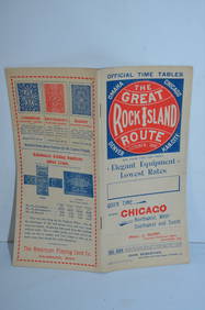
Chicago Rock Island and Pacific RY October 1896 Public TimetableJM Hobby Supply and Railroad Artifact Auctions4.4(127)See Sold PriceFeb 24, 2024
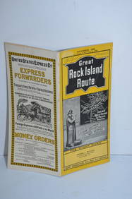
Chicago Rock Island and Pacific RY November 4, 1899 Public TimetableJM Hobby Supply and Railroad Artifact Auctions4.4(127)See Sold PriceFeb 24, 2024
17TH C. MAP OF THE BERKSHIRES BY JOHN SPEED, FRAMEDThomaston Place Auction Galleries4.4(393)See Sold PriceFeb 24, 2024
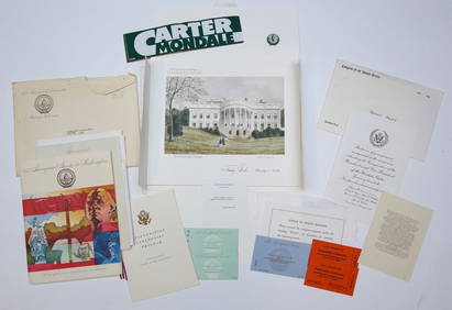
1977 INAUGURATION of PRESIDENT JIMMY CARTERJohn McInnis Auctioneers,LLC4.5(505)See Sold PriceFeb 25, 2024
Natural History - Campo Del Cielo Iron MeteoriteTimeLine Auctions Ltd.4.6(183)See Sold PriceMar 09, 2024
Natural History - Campo Del Cielo Iron MeteoriteTimeLine Auctions Ltd.4.6(183)See Sold PriceMar 09, 2024
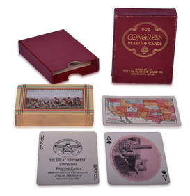
Fred Harvey Railroad Early Souvenir Playing Cards of the Great Southwest - Indians and Train SmokeRail & Road Auctions4.6(165)See Sold PriceMar 08, 2024
Rand McNally Railroad Map Cabinet w/ 21 Railroad MapsRail & Road Auctions4.6(165)See Sold PriceMar 08, 2024
Guthrie, William 1812 Antique Map. Spain and PortugalAlbion Auctions4.7(341)See Sold PriceMar 01, 2024
1947 United Airlines Mainliner Flight Informational PacketMatthew Bullock Auctioneers4.7(1.8k)See Sold PriceMar 02, 2024
John Senex Map of Louisiana & Mississippi RiverWillow Auction House4.5(289)See Sold PriceMar 14, 2024


![JOHN SENEX (1678 - 1740) Map of Ireland [1728] 96 x (1 of 1)](https://p1.liveauctioneers.com/533/198713/100429132_1_x.jpg?height=282&quality=70&version=1616763268)