Vintage Ca. 1940's International Panel Delivery Truck Converted into Stationary Food Truck, WasSwisher Bros. Auction LLC4.4(251)See Sold PriceFeb 25, 2024
Martin Custom Acoustic Guitar 000 Body Style Rosewood with Hard CaseHess Fine Auctions4.5(202)See Sold PriceMar 02, 2024
1968 Gibson LG-0 Acoustic Dreadnought Parlor GuitarHess Fine Auctions4.5(202)See Sold PriceMar 02, 2024
Replica Robinson 1862 Sharps CarbineSchmidt's Antiques Inc. Since 19114.8(431)See Sold PriceMar 02, 2024
PAIR (18th c) OF FLINTLOCK DUELING PISTOLSJohn McInnis Auctioneers,LLC4.6(504)See Sold PriceFeb 24, 2024
PAIR T KETLAND of LONDON .60 CAL FLINTLOCK PISTOLSJohn McInnis Auctioneers,LLC4.6(504)See Sold PriceFeb 25, 2024
Gibson ES335 Semi Hollow Vintage Sunburst Electric Guitar with Certificate of Authenticity Hand MadeHess Fine Auctions4.5(202)See Sold PriceMar 02, 2024
WALT DISNEY WORLD - Figment Animatronic Character Skin from EPCOT's Journey Into ImaginationPropstore4.2(6)See Sold PriceMar 12, 2024
Lot Of 3 Early Large Three-Ring Binders Full Of Thousands Of StampsRbfinearts4.4(575)See Sold PriceFeb 24, 2024
A FINE PERSIAN MALAYER PRAYER RUG WITH CYPRESS C. 1860Soulis Auctions4.8(953)See Sold PriceFeb 24, 2024
Thomas Hart Benton; 20thC. American Regionalist Oil SignedMid-Hudson Auction Galleries4.4(470)See Sold PriceFeb 24, 2024
Fender USA Stratocaster Electric Guitar Classic Candy Red and White Original Stickers with Gig BagHess Fine Auctions4.5(202)See Sold PriceMar 02, 2024
1986 Fender Stratocaster Japan Blue-Green with White Pickguard and Gig Bag JapaneseHess Fine Auctions4.5(202)See Sold PriceMar 02, 2024
SoldJOHN SENEX MAP OF INDIA & CHINA dated 1720Borders and boundaries hand colored on laid paper. 19 1/2 x 23 inches (plate). framed 23 x 27 inches (overall)See Sold Price
SoldSENEX, John (1678-1840). A New Map of India &SENEX, John (1678-1840). A New Map of India & China.London: ca. 1720-40 (535mm x 640 mm). Engraved map hand-colored in outline. Framed. An appealing and highly-detailed map of Southeast ASee Sold Price
SoldSenex, A New Map Of China & India c.1721[Asia/Indonesia]. John Senex. A New Map Of India & China From the latest Observations. Double-page engraved map, from ''A New General Atlas,'' Lon: c.1721. Early outline hand-coloring, 19 3/8 x 22 7/8See Sold Price
SoldJohn Senex engraved mapJohn Senex- ''A New Map of India and China from Latest Observations''- engraved map, with outline color, paper toning. 19 1/4 x 23 1/4''See Sold Price
John Senex (1678 - 1740)A New Map of India and China from the latest Observations 1721 hand-colored copperplate engraving 21” x 25” (53 cm x 64 cm)See Sold Price
1881 Map of IndiaTitle: 1881 Map of India Medium: Ink on Paper Dimensions: 15"X12.5" Description: Map of India, Farther India, China and Tibet dated 1881. Published by Mitchell in Washington D.C. Key lower middle. VerSee Sold Price
1881 Map of India, Farther India, China and TibetAuthor: Mitchell Title: 1881 Map of India, Farther India, China and Tibet Medium: Ink on Paper Dimensions: 15"X12.5" Map of India, Farther India, China and Tibet dated 1881. Published by Mitchell in WSee Sold Price
1881 Map of IndiaAuthor: Mitchell Title: 1881 Map of India Medium: Ink on Paper Dimensions: 15"X12.5" Description: Map of India, Farther India, China and Tibet dated 1881. Published by Mitchell in Washington D.C. KeySee Sold Price
1881 Map of IndiaAuthor: Mitchell Title: 1881 Map of India Medium: Ink on Paper Dimensions: 15"X12.5" Map of India, Farther India, China and Tibet dated 1881. Printed and published by Mitchell in Washington D.C. Key lSee Sold Price
SoldJohn Senex a New Map of City of London 1720John Senex (1678-1740), "A Plan of the City's of London, Westminster and Borough of Southwark with the new Additional Buildings," Cassell, London: Petter and Galpin, 1720. Copper engraving on paper. DSee Sold Price
John Senex Map of EuropeA New Map of Europe From the Latest Observations, "Inscribed to the Honorable Samuel Molyneux, Esq., Secretary to His R.H. the Prince" by John Senex, undated, circa 1720, double page hand-colored engrSee Sold Price
SoldJohn Senex. New Map of Virginia, Maryland,(English, 1678-1740). dated 1719, "A New Map of Virginia, Maryland and The Improved Parts of Pennsylvania & New Jersey" hand colored map, 22 3/4 x 20 3/4 in., in silvered and painted wood frameSee Sold Price
SoldJohn Senex. Engraved Map of Amsterdam(British, c.1678-1740). "A New Map of the City of Amsterdasm, Most Humbly Inscrib'd to John Hedworth, Esq." 1720, sight size: 20 1/4 x 23 1/4 in., framedSee Sold Price
SoldAntique map, John Senex, IrelandFramed hand-colored engraved map, A New Map of Ireland from the Latest Observations (1720-), by John Senex (British, 1678-1741), plate: 23''h x 19''w, overall: 31''h x 26.5''wSee Sold Price
Sold(MAP) SENEX, JOHN. A Map of Greece with part of(MAP) SENEX, JOHN A Map of Greece with part of Anatolia. [London], 1720. Double-page engraved map, hand-colored in outline, depicting Greece, the Greek islands, and Western Turkey. With decorative carSee Sold Price
Sold18th Century Hand Colored Map of HungaryPublished: Ca. 1720, London. Author: John Senex Hand Colored map framed under glass. 22.5" W x 18.5" HSee Sold Price
SoldMap of Amsterdam by John Senex, 1720MAP. A new map of the City of Amsterdam, John Senex, 1720 "Most humbly Inscribed to John Hedworth, ESQ" fine town plan of Amsterdam, oriented with north at Boston, engraved by Samuel Parker with streeSee Sold Price
SoldParker (Samuel) & Senex (John) A Plan of the City’s ofParker (Samuel) & Senex (John) A Plan of the City’s of London, Westminster and Borough of Southwark, with the new Additional Buildings, Anno 1720, a detailed map of early Georgian London, from ‘ASee Sold Price
SoldSenex (John) - A New Map of London, A Plan of theA New Map of London, A Plan of the City's of London, Westminster and Borough of Southwark, with the new Additional Buildings, Anno 1720, from Highgate to Lambeth Bridge, and from Hyde Park to WhitechaSee Sold Price
SoldSenex PLAN OF THE CITIES OF LONDON WESTMINSTER ANDDetails: SENEX, John (1678-1740). A Plan of the City's of London, Westminster and Borough of Southwark with the new Additional Buildings Anno 1720. London: Senex, 1720. Copper-engraved map by SamuelSee Sold Price
SoldMap of North America by John Senex dated 1710.English map of North America by John Senex dated 1710. From the collection of Shreve, Crump and Low Co., Boston MA. Framed 1950 in Salzburg, Austria.29" x 41 1/2" Advertised in Antiques" April 1, 1975See Sold Price
SoldBartholomew, John 1922 Group of 3 Maps of AsiaSouth Western Asia, Asia - Political, and Father India showing Siam and Indo China. Large Lithograph Maps Published 1922 by The Times, London for "The Times Survey Atlas of the World" Maps by John GeoSee Sold Price
SoldUSAAF ARMY AIR FORCE CREW SILK ESCAPE MAPApprox. 20.25" by 25.15". Covers Northeast China. Dated 12/44. For the China Burma India area campaign.See Sold Price
The Islands of The East Indies, Carey, 1814The Islands of The East Indies. M. Carey, Scoles, John. 1814. "with the channels between India, China & New Holland." Quarto – 8.50 H x 11.00 W Inches Please note that this lot has a confidential reSee Sold Price
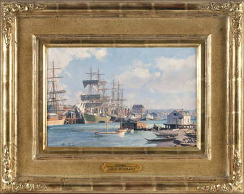
JOHN STOBART (Massachusetts/Florida/England, 1929-2023), "Victoria, View from Songhee Point, 1891".,Eldred's4.7(418)See Sold PriceFeb 27, 2024
Hand Colored Map of the city of Amsterdam 1720Global Auctions Company4.3(36)See Sold PriceMar 03, 2024
Guthrie, William 1812 Antique Map. Spain and PortugalAlbion Auctions4.6(341)See Sold PriceMar 01, 2024
ANTIQUE ILLUSTRATED HANDBOOK OF GEOGRAPHY AND TRAVEL IN ASIA, VOLUME 2, 1896NY Elizabeth 4.3(85)See Sold PriceMar 03, 2024
John Senex Map of Louisiana & Mississippi RiverWillow Auction House4.5(284)See Sold PriceMar 14, 2024