ATLAS of ANTIENT GEOGRAPHY by SAMUEL BUTLER 1843John McInnis Auctioneers,LLC4.6(504)See Sold PriceFeb 24, 2024
18TH C. ANTIQUE MAP: FRENCH & INDIAN WAR, FRAMEDThomaston Place Auction Galleries4.4(389)See Sold PriceFeb 24, 2024
Rand McNally Railroad Map Cabinet w/ 21 Railroad MapsRail & Road Auctions4.6(165)See Sold PriceMar 08, 2024
Keith Haring - Ink on New York Map, Best Buddies, Inscribed, Signed, and DatedSapphire Auction Gallery4.1(67)See Sold PriceMar 02, 2024
LATE 17TH C. FRENCH MAP OF THE NEW WORLD BY ALEXIS-HUBERT JAILLOT (1632-1712)Thomaston Place Auction Galleries4.4(389)See Sold PriceFeb 24, 2024
Central Railroad of New Jersey Map of Sandy Hook Route-ca. 1903JM Hobby Supply and Railroad Artifact Auctions4.4(126)See Sold PriceFeb 24, 2024
Lot of Six Mixed Atlas Box Cars-HO Scale-New in BoxJM Hobby Supply and Railroad Artifact Auctions4.4(126)See Sold PriceFeb 25, 2024
Rand McNally/Santa Fe Railroad Map of Iowa-1912JM Hobby Supply and Railroad Artifact Auctions4.4(126)See Sold PriceFeb 24, 2024
NICOLAES VISSCHER (NETHERLANDS, 1618-1709) MAP OF THE NEW WORLDThomaston Place Auction Galleries4.4(389)See Sold PriceFeb 24, 2024
17TH C. WORLD MAP BY NICOLAES VISSCHER (NETHERLANDS, 1618-1709)Thomaston Place Auction Galleries4.4(389)See Sold PriceFeb 24, 2024
Lot of Six Mixed Atlas Cabooses-HO Scale-New in BoxJM Hobby Supply and Railroad Artifact Auctions4.4(126)See Sold PriceFeb 25, 2024
SoldJohn Cary New Map of France Engraving 1799John Cary (ca. 1754–1835), "A New Map of France, Divided into Departments, as decreed by the National Assembly, MDCCXC," 1799. Hand colored engraved map of France. Dimensions: Sight; height: inSee Sold Price
SoldCARY, FRANCE, SWISSERLAND- (2) HC ENGR,C.1800Artist: John Cary, Title: A New Map of France & New Map of Swisserland - two, Printmaker: John Cary, Pub: John Cary, Date: C.1806 & C.1799, Medium: Hand-colored engraving, Paper size: 20 1/2 x 24 eachSee Sold Price
SoldJohn Cary: Westphalia GermanyMap: A New Map of the Circle of Westphalia (Germany) Maker: John Cary From Cary's New Universal Atlas Origin: London Date: 1808 (Map dated 1799) Medium: Engraving hand-colored at publication Sheet SizSee Sold Price
SoldCARY, DENMARK & FRANCE (2), HC ENGR, C.1801Artist: John Cary, Title: A New Map of the Kingdom of Denmark & A New Map of France (two prints), Printmaker: John Cary, Pub: John Cary, Date: C.1801, Medium: Hand-colored copperplate engraving, PaperSee Sold Price
SoldJOHN CARYA New Map of Italy, Including The Islands of Sicily, Sardinia and Corsica, with the Post Roads… 1799 Hand Colored engraving on paper Dimensions: 20" x 23" Note: "Gorgeous large format map of Italy,See Sold Price
SoldA New Map Of The Russian Empire, 1799.[Russia]. J. Cary. A New Map Of the Russian Empire. Divided into its Governments. Double-page engraving. Lon: John Cary, 1799. 18 x 39 3/4 in. Contemporary hand-coloring, with mountain ridges and swamSee Sold Price
JOHN CARYA New Map of Italy, Including The Islands of Sicily, Sardinia and Corsica, with the Post Roads… 1799 Hand Colored engraving on paper Dimensions: 20" x 23" Note: "Gorgeous large format map of ItaSee Sold Price
SoldMap of post-revolutionary provinces in FranceHeading: Author: Cary, [John] Title: Cary's new map of France, Divided into Departments, as Decreed by the National Assembly January 1st, 1790 on Which are also Delineated, the Boundaries of its FormSee Sold Price
SoldCary (John) New Map of France, Divided into DepartCary (John) New Map of France, Divided into Departments, as decreed by the National Assembly, January 1st 1790,William Houstoun's copy, engraved map with original hand-colouring in outline, 61See Sold Price
FFRAN Cary (John) New Map of France, Divided intoFFRAN Cary (John) New Map of France, Divided into Departments, as decreed by the National Assembly, January 1st 1790,William Houstoun's copy, engraved map with original hand-colouring in outliSee Sold Price
John Cary: A New Map of the Circle of Bavaria, 1799By: John Cary Date: 1799 (Dated) London Dimensions: 18 x 20 inches (45.7 cm x 50.8 cm) Description: This is an authentic hand-colored antique map by the prominent cartographer John Cary, which depictsSee Sold Price
SoldJohn Cary A New Map of Durham 1811 18.5in. x 21inJohn Cary coloured engraving A New Map of Durham 1811 18.5in. x 21in.See Sold Price
Sold1799 Map ITALY JOHN CARY "A New Map of Piedmont" 18th CA beautifully engraved and colored 18th Century map of Italy. This piece is entitled: "A New Map of Piedmon the Duchies of Savoy and Milan; and the Republic of Genoa; with their Subdivisions." EngraveSee Sold Price
SoldAFTER JOHN CARY, NEW MAP OF SUSSEX, C. 1801After John Cary (British 1754-1835), "A New Map of Sussex, Divided Into Hundreds, Exhibiting Its Roads, Rivers, Parks & C.", circa 1801, colored copper engraving, topographical map depicting the EngliSee Sold Price
SoldJohn Cary 'New map of the Principality of Wales'John Cary 'New map of the Principality of Wales' hand coloured engraving, published 1809, unframed, 47cm x 56 cm also one other map by Cary and five county maps by C & J Greenwood (7)See Sold Price
1799 Map ITALY JOHN CARY "A New Map of Piedmont" 18th CThis is a beautifully engraved and colored 18th Century map of Italy. This piece is entitled: "A New Map of Piedmon the Duchies of Savoy and Milan; and the Republic of Genoa; with their Subdivisions."See Sold Price
SoldIreland.- Cary (John) Cary's New Map of Ireland,Ireland.- Cary (John) Cary's New Map of Ireland, exhibiting the whole of the Turnpike Roads with the Rivers and Canals, engraving with original hand-colouring in outline, 770 x 620 mm (30 x 24 1/4 in)See Sold Price
SoldJohn Cary Map, "A New Map of China" 1801, hand coloredJohn Cary Map, "A New Map of China" 1801, hand colored engraving, 21-1/2" x 25-1/2" sheet, discoloration, especially at lower marginSee Sold Price
SoldEngland & Wales.- Cary (John) Cary's New Map of EnglandEngland & Wales.- Cary (John) Cary's New Map of England & Wales with Part of Scotland..., disbound with title, general map, dedication, and explanation leaf, and remaining map sheets 1-81, engravingsSee Sold Price
Two Maps by John Cary (1754-1835), "A New Map of theTwo Maps by John Cary (1754-1835), "A New Map of the Circe of Lower Saxony," 1801; together with "A New Map of France, Division into Provinces," 1806, H.-1 9 1/2 in., W.- 22 1/2 in. and H.- 21 3/8 in.See Sold Price
MAP, Persia - Iran, CaryPersia - Iran. John Cary, A New Map of Persia, from the Latest Authorities, 1801 (dated). Hand Color. This is a fine map of early nineteenth century Persia. The finely engraved map is divided into proSee Sold Price
SoldJohn Cary: Lower Saxony Germany 1808Map: A New Map of the Circle of Lower Saxony (Germany) Maker: John Cary From Cary's New Universal Atlas Origin: London Date: 1808 (Map dated 1801) Medium: Engraving hand-colored at publication Sheet SSee Sold Price
Sold18TH CENTURY MAP OF FRANCE18TH CENTURY MAP OF FRANCE, hand-colored, titled "A NEW MAP OF FRANCE, DIVIDED into DEPARTMENTS, as decreed by the NATIONAL ASSEMBLY, MDCCXC. FROM THE LATEST AUTHORITIES, By JOHN CARY, Engraver. 1799"See Sold Price
SoldJohn Cary (British, 1754-1835) Framed Map AssortmentJohn Cary (British, 1754-1835) Framed Map Assortment c.1875, (3) maps including a 1799 'New Map of Germany,' 1804 'New Map of Europe' and 1805 'New Map of Africa' Height: 18.50 inches, Width: 21.75 inSee Sold Price
LARGE LATE 17TH C. DUTCH CHART OF CANADA, GREAT LAKES, NEW FRANCE, LABRADOR, HUDSON BAY, BY PIERREThomaston Place Auction Galleries4.4(389)See Sold PriceFeb 24, 2024
WESLEY REV. JOHN Sermons On Several Occasions c1854 Full Tree Calf Vol. IILuis Porretta Fine Arts4.3(10)See Sold PriceMar 02, 2024
Vintage County Map Of NY State Plate EngravingThe Benefit Shop Foundation Inc.4.3(2.9k)See Sold PriceFeb 28, 2024
Johann Homann Hand-Colored Map Engraving, c. 1730Auctions at Showplace4.6(731)See Sold PriceMar 17, 2024
D'Entrecasteaux - Australia: Coasts of Van Diemen's Land (New Holland). 9Trillium Antique Prints & Rare Books4.5(30)See Sold PriceFeb 24, 2024
D'Entrecasteaux - Australia: Chart of Van Diemen's Land (New Holland). 3Trillium Antique Prints & Rare Books4.5(30)See Sold PriceFeb 24, 2024
D'Entrecasteaux - Map of Australia (New Holland), New Zealand, and southern Asia and surroundingTrillium Antique Prints & Rare Books4.5(30)See Sold PriceFeb 24, 2024
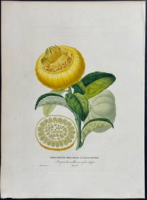
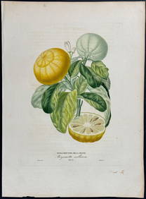
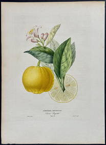
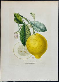
Risso - Lemon or Citrus Fruit. 73Trillium Antique Prints & Rare Books4.5(30)See Sold PriceFeb 24, 2024
Risso - Lemon or Citrus Fruit. 71Trillium Antique Prints & Rare Books4.5(30)See Sold PriceFeb 24, 2024
Map: A 19thC engraved and hand coloured map of Buckingham titled A New Map of BuckinghamshireClaydon Auctioneers Ltd4.3(125)See Sold PriceFeb 26, 2024
1738 RUSSIA SIBERIA & GREAT TARTARY Description illustrated ANTIQUE in ENGLISHJasper524.5(9.8k)See Sold PriceFeb 27, 2024
Robert Benard (1734 - 1777) - Set of 9 Copperplate Engravings - Greek and Roman architecture - ViewProverde Auctions4.3(3)See Sold PriceFeb 28, 2024
Robert Benard (1734 - 1777) - Set of 9 Copperplate Engravings - Architecture, Masonry, Quarry withProverde Auctions4.3(3)See Sold PriceFeb 28, 2024
Robert Benard (1734 - 1777) - Set of 9 Chemical Engravings - Alchemical symbols - Utensils forProverde Auctions4.3(3)See Sold PriceFeb 28, 2024
Herman Moll A New Map of Ye North Parts of AmericaWillow Auction House4.5(284)See Sold PriceMar 14, 2024