SoldJohn Cary Travel Celestial Globe in Box marked Cary &John Cary Travel Celestial Globe in Boxmarked Cary & Co., London, No. 21540having George Lee & Son Optical and Nautical Instrument, established 1847, label on inside of the boxalso handwritten on insiSee Sold Price
SoldAN 1811 UNITED STATES MAP BY JOHN CARYA New Map of Part of the United States of North America Exhibiting the Western Territory, Kentucky, Pennsylvania, Maryland, Virginia & c. also the Lakes Superior Michigan Huron Ontario & Erie with UppSee Sold Price
John Cary: Map of the Middle States, 1806Map: Middle States Maker: John Cary Date: 1806 Size: 30 x 30 inches Medium: Original copperplate engraving John Cary (1754-1835) was an English cartographer who is known for his maps, globes, and hisSee Sold Price
SoldJOHN CARY 1799 MAP OF IRELANDHand colored engraving. Dimensions: (Paper) H 20" x W 26" Condition: Toning and wrinkles. With center fold and small worm holes.See Sold Price
Sold"A New Map of North America" by John Cary, 1806John Cary (English, 1754-1835). An engraved map with hand coloring by famed cartographer John Cary, whose maps of North America documented the wide ranging unknown, especially surrounding the MidwestSee Sold Price
Sold1812 John Cary Map ofTitled "A New Map of Part of the United States of North America", published by J. Cary, London, 1812. There are a few small pinholes, and one small hole in the bottom center along the center fold.See Sold Price
SoldJohn Cary, Map United States, Treaty of Peace 1783John Cary (London, 1754-1835) "An Accurate Map of the United States of America, with Part of the Surrounding Provinces agreeable to the Treaty of Peace of 1783", 1783 (created/published) Hand coloredSee Sold Price
Sold1811 Map of the United States, John CaryAntique hand colored map of part of the United States, engraved by John Cary, 1811. Sight size is 18" tall.See Sold Price
SoldA John Cary Pocket Globe with Shagreen Case, LonA John Cary Pocket Globe with Shagreen Case, London, 1791 Marks to globe: Cary's Pocket Globe. Agreeable to the Latest Discoveries. London: J & W Cary Strand, April 1, 1791. 3 inches (7.6 cm) (gloSee Sold Price
SoldPair of John Cary Mapsa new map of North America, a new map of part of the United States each 18" x 20" SHIPPING: Buyer is responsible for arranging 3rd party shipping. Also see 3rd party shipper list provided in SHIPPINGSee Sold Price
A New Map of Piedmont by John Cary 1799Map: A New Map of Piedmont Maker: John Cary Size: Folio - 17.75 inches high x 20.25 inches wide Date: 1799 "The Duchies of Savoy and Milan; and the Republic of Genoa; with their subdivisions." PleaseSee Sold Price
John Cary: New Map of the Kingdom of Portugal 1801Map: A New Map of the Kingdom of Portugal, Divided Into Its Provinces, from the Latest Authorities Maker: John Cary Publishing: London 1801 Size: 18 x 20.5 inches Detailed map of its topography, proviSee Sold Price
John Cary: Map of the Russian Empire, 1799Map: A New Map of the Russian Empire, Divided into its Governments; from the Latest Authorities Maker: John Cary Date: 1799 Origin: London Size: 18 x 40 inches A magnificent map of the Russian EmpireSee Sold Price
SoldJOHN CARYA New Map of Italy, Including The Islands of Sicily, Sardinia and Corsica, with the Post Roads… 1799 Hand Colored engraving on paper Dimensions: 20" x 23" Note: "Gorgeous large format map of Italy,See Sold Price
SoldJohn Cary: Brazil & Buenos Aires 1815Map: Brazil & Buenos Aires Publishing: John Cary Date: 1815 Size: 11 x 14 inches Original copper engraving John Cary (1754-1835) was an English cartographer who is known for his maps, globes, and hisSee Sold Price
SoldJohn Cary: Portugal 1819Map: Portugal Maker: John Cary Publishing: John Cary, London Date: 1819 Size: 11 x 8.9 inches (280 x 225mm) Medium: Hand colored engraving From Cary's New Universal Atlas John Cary (1754-1835) was anSee Sold Price
John Cary: A New Map of the Circle of Bavaria, 1799By: John Cary Date: 1799 (Dated) London Dimensions: 18 x 20 inches (45.7 cm x 50.8 cm) Description: This is an authentic hand-colored antique map by the prominent cartographer John Cary, which depictsSee Sold Price
John Cary: Germany, Divided into Circles 1819Map: Germany, Divided into Circles Maker: John Cary Publishing: John Cary, London Date: 1819 Size: 9 x 11.2 inches (230 x 282mm) Medium: Hand colored engraving From Cary's New Universal Atlas John CarSee Sold Price
SoldJohn Cary. A New Map Of America. 1806 [ca. 1808].[Cary, John/America New Map] A NEW MAP OF AMERICA, From the Latest Authorities By John Cary, Engraver. 1806. From an edition of Cary’s “New Universal Atlas.” [C. 1808. Phillis, Atlases, 714 listSee Sold Price
SoldJohn Cary (British, 1754-1835)John Cary (British, 1754-1835), "A New Map of Part of The United States of North America Containing the Carolinas and Georgia, also The Floridas and Part of The Bahama Islands & C.", London, 1806, hanSee Sold Price
SoldJohn Cary: Westphalia GermanyMap: A New Map of the Circle of Westphalia (Germany) Maker: John Cary From Cary's New Universal Atlas Origin: London Date: 1808 (Map dated 1799) Medium: Engraving hand-colored at publication Sheet SizSee Sold Price
SoldJohn Cary: Lower Saxony Germany 1808Map: A New Map of the Circle of Lower Saxony (Germany) Maker: John Cary From Cary's New Universal Atlas Origin: London Date: 1808 (Map dated 1801) Medium: Engraving hand-colored at publication Sheet SSee Sold Price
SoldJohn Cary. A NEW MAP OF AMERICA 1806, [ca. 1808].[New World] A NEW MAP OF AMERICA, From the Latest Authorities By John Cary, Engraver. 1806. From an edition of Cary’s “New Universal Atlas.” [C. 1808. Phillis, Atlases, 714 lists this as Plate 5See Sold Price
Sold1799 Map ITALY JOHN CARY "A New Map of Piedmont" 18th CA beautifully engraved and colored 18th Century map of Italy. This piece is entitled: "A New Map of Piedmon the Duchies of Savoy and Milan; and the Republic of Genoa; with their Subdivisions." EngraveSee Sold Price
PAIR (18th c) OF FLINTLOCK DUELING PISTOLSJohn McInnis Auctioneers,LLC4.6(502)See Sold PriceFeb 24, 2024
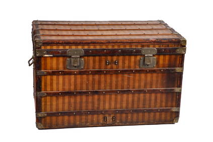
GREAT EARLY (19th c) LOUIS VUITTON STEAMER TRUNKJohn McInnis Auctioneers,LLC4.6(502)See Sold PriceFeb 25, 2024
PAIR T KETLAND of LONDON .60 CAL FLINTLOCK PISTOLSJohn McInnis Auctioneers,LLC4.6(502)See Sold PriceFeb 25, 2024
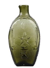
RARE COVENTRY GLASS WORKS MASONIC FLASKJohn McInnis Auctioneers,LLC4.6(502)See Sold PriceFeb 25, 2024
AMERICAN SCHOOL (Early 20th c) Two WorksJohn McInnis Auctioneers,LLC4.6(502)See Sold PriceFeb 25, 2024
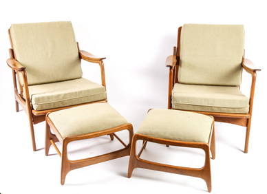
PAIR of HANS WEGNER-STYLE MID-CENTURY RECLINING LOUNGERSJohn McInnis Auctioneers,LLC4.6(502)See Sold PriceFeb 25, 2024
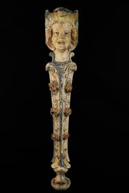
ILLIONS SUPREME CAROUSEL FIGURAL DIVIDER PANELJohn McInnis Auctioneers,LLC4.6(502)See Sold PriceFeb 25, 2024
ANTIQUE BLACK AMERICANA CAST IRON LAWN JOCKEYJohn McInnis Auctioneers,LLC4.6(502)See Sold PriceFeb 25, 2024
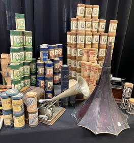
GRAPHAPHONE, EDISON PHONOGRAPH and RECORDSJohn McInnis Auctioneers,LLC4.6(502)See Sold PriceFeb 25, 2024
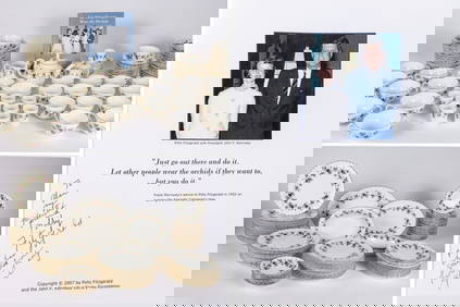
THE FITZGERALD FAMILY TEA and DINNER SERVICEJohn McInnis Auctioneers,LLC4.6(502)See Sold PriceFeb 25, 2024
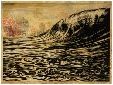
Shepard Fairey (b. 1970), "Dark Wave," 2010, Screenprint, collage, and hand-painted (HPM) on paper,John Moran Auctioneers, Inc.4.7(453)See Sold PriceFeb 27, 2024
Doyle Lane (1923-2002), A ceramic "Weed Pot," circa 1962-1976John Moran Auctioneers, Inc.4.7(453)See Sold PriceFeb 27, 2024
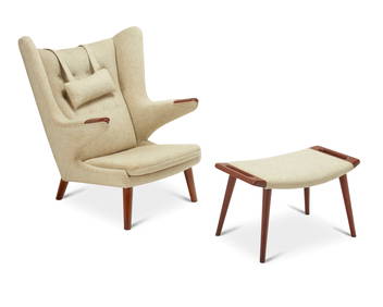
Hans Wegner (1914-2007), AP-19 Papa Bear chair and ottoman for A.P. Stolen, 1953-1969; DenmarkJohn Moran Auctioneers, Inc.4.7(453)See Sold PriceFeb 27, 2024
Map: A 19thC engraved map titled Gloucestershire from the Best Authorities, after John Cary. Approx.Claydon Auctioneers Ltd4.3(125)See Sold PriceFeb 26, 2024
Map: A 19thC engraved and hand coloured map of Buckingham titled A New Map of BuckinghamshireClaydon Auctioneers Ltd4.3(125)See Sold PriceFeb 26, 2024
Map: A 19thC engraved map of West Riding, titled A Map of the North Part of the West Riding ofClaydon Auctioneers Ltd4.3(125)See Sold PriceFeb 26, 2024


![John Cary. A New Map Of America. 1806 [ca. 1808]. (1 of 3)](https://p1.liveauctioneers.com/179/93063/47518594_1_x.jpg?height=282&quality=70&version=1472482862)


![John Cary. A NEW MAP OF AMERICA 1806, [ca. 1808]. (1 of 3)](https://p1.liveauctioneers.com/179/82189/42599758_1_x.jpg?height=282&quality=70&version=1447864785)