ATLAS of ANTIENT GEOGRAPHY by SAMUEL BUTLER 1843John McInnis Auctioneers,LLC4.5(505)See Sold PriceFeb 24, 2024
18TH C. ANTIQUE MAP: FRENCH & INDIAN WAR, FRAMEDThomaston Place Auction Galleries4.4(393)See Sold PriceFeb 24, 2024
Rand McNally Railroad Map Cabinet w/ 21 Railroad MapsRail & Road Auctions4.6(165)See Sold PriceMar 08, 2024
Keith Haring - Ink on New York Map, Best Buddies, Inscribed, Signed, and DatedSapphire Auction Gallery4(67)See Sold PriceMar 02, 2024
LATE 17TH C. FRENCH MAP OF THE NEW WORLD BY ALEXIS-HUBERT JAILLOT (1632-1712)Thomaston Place Auction Galleries4.4(393)See Sold PriceFeb 24, 2024
Central Railroad of New Jersey Map of Sandy Hook Route-ca. 1903JM Hobby Supply and Railroad Artifact Auctions4.4(127)See Sold PriceFeb 24, 2024
Lot of Six Mixed Atlas Box Cars-HO Scale-New in BoxJM Hobby Supply and Railroad Artifact Auctions4.4(127)See Sold PriceFeb 25, 2024
Rand McNally/Santa Fe Railroad Map of Iowa-1912JM Hobby Supply and Railroad Artifact Auctions4.4(127)See Sold PriceFeb 24, 2024
NICOLAES VISSCHER (NETHERLANDS, 1618-1709) MAP OF THE NEW WORLDThomaston Place Auction Galleries4.4(393)See Sold PriceFeb 24, 2024
17TH C. WORLD MAP BY NICOLAES VISSCHER (NETHERLANDS, 1618-1709)Thomaston Place Auction Galleries4.4(393)See Sold PriceFeb 24, 2024
Lot of Six Mixed Atlas Cabooses-HO Scale-New in BoxJM Hobby Supply and Railroad Artifact Auctions4.4(127)See Sold PriceFeb 25, 2024
SoldILN 1856 Large Ship Print & Map (Trimmed)"The Fleet of the Great Naval Review at Spithead" Together with "Picture Map of the Baltic Sea" on the reverse. Large Wood Engraving Published 1856, London for "The Illustrated London News" Folds as iSee Sold Price
SoldSet of 2 Framed Prints of Antique MapsSet of 2 Framed Antique Maps - Small map of England and Scotland. Large Map of the Mediterranean with ships. Measures approx. Large map 28" tall x 31" w x 1" deep. Small map 12" tall x 15" w x 3/4" deSee Sold Price
SoldLarge framed Southern Pacific map printLarge very nicely framed Southern Pacific map print. Frame measures 33 inches wide by 45 inches tall. See photos for best description. Due to the size we will not be able to ship this lot, pick up arrSee Sold Price
SoldHayward (George) Map of the City of New York, 1856Hayward (George) Map of the City of New York, 1856,showing southern Manhattan, with large inset of the rest of Manhattan, from Valentine's Manual, lithograph with some outline hand-colouring,See Sold Price
SoldPhilip, George 1856 LG Hand Col Map. Russia in EuropeLarge Folio Lithograph Map Published Published 1856 by George Philip, Liverpool for "Philips' Commercial Atlas of the World" Paper Size: 26 x 21 inch (66 x 53cm) Light horizontal bend in centre. NeatlSee Sold Price
SoldPhilip, George 1856 LG Hand Col Map. BelgiumLarge Folio Lithograph Map Published Published 1856 by George Philip, Liverpool for "Philips' Commercial Atlas of the World" Paper Size: 26 x 21 inch (66 x 53cm) Light horizontal bend in centre. NeatlSee Sold Price
SoldPhilip, George 1856 LG Hand Col Map. DenmarkLarge Folio Lithograph Map Published Published 1856 by George Philip, Liverpool for "Philips' Commercial Atlas of the World" Paper Size: 26 x 21 inch (66 x 53cm) Light horizontal bend in centre. NeatlSee Sold Price
SoldPhilip, George 1856 LG HCol Map. Martinico, DominicaLarge Folio Lithograph Map Published Published 1856 by George Philip, Liverpool for "Philips' Commercial Atlas of the World" Paper Size: 26 x 21 inch (66 x 53cm) Light horizontal bend in centre. NeatlSee Sold Price
SoldPhilip, George 1856 LG Hand Col Map. Germany North PartLarge Folio Lithograph Map Published Published 1856 by George Philip, Liverpool for "Philips' Commercial Atlas of the World" Paper Size: 26 x 21 inch (66 x 53cm) Light horizontal bend in centre. NeatlSee Sold Price
SoldPhilip, George 1856 LG Hand Col Map. Germany South PartLarge Folio Lithograph Map Published Published 1856 by George Philip, Liverpool for "Philips' Commercial Atlas of the World" Paper Size: 26 x 21 inch (66 x 53cm) Light horizontal bend in centre. NeatlSee Sold Price
SoldPhilip, George 1856 LG Hand Col Map. BelgiumLarge Folio Lithograph Map Published Published 1856 by George Philip, Liverpool for "Philips' Commercial Atlas of the World" Paper Size: 26 x 21 inch (66 x 53cm) Light horizontal bend in centre. NeatlSee Sold Price
Large - HENRY DARWIN ROGERS "GEOLOGICAL MAP OF TThis Is A HENRY DARWIN ROGERS Giclee on Canvas Titled "GEOLOGICAL MAP OF THE UNITED STATES, 1856" Measuring - 44 x 36 5/8 in. This Giclée is high-resolution and of the highest quality, has a color peSee Sold Price
Map of Florida, DeSilver & Mitchell, 1856Original lithograph from "A New Universal Atlas" by DeSilver & Mitchell, 1856. Displayed in a wood frame and UV glass. Dimensions: 23.75" L x 21.5" W x 1.5" H This item ships from Ocean View, DE.See Sold Price
SoldN. Currier, publisher (American, 1838-1856) ClippeN. Currier, publisher (American, 1838-1856) Clipper Ship "Flying Cloud.," 1852 (Conningham, 1163). Identified in inscriptions in the matrix. Large folio lithograph with hand-coloring on paper, sheSee Sold Price
Nathaniel Currier, publisher (American, 1813-1888Nathaniel Currier, publisher (American, 1813-1888) CLIPPER SHIP "OCEAN EXPRESS.," 1856 (Conningham, 1160). Identified in inscriptions in the matrix. Large folio lithograph with hand-coloring on paSee Sold Price
SoldNathaniel Currier, publisher (American, 1813-1888)Nathaniel Currier, publisher (American, 1813-1888) Clipper Ship Dreadnought Off Tuskar Light, 1856 (Conningham, 1144). Identified in inscriptions in the matrix. Large folio lithograph with handSee Sold Price
SoldNathaniel Currier, publisher (American, 1813-1888)Nathaniel Currier, publisher (American, 1813-1888) CLIPPER SHIP "OCEAN EXPRESS.," 1856 (Conningham, 1160). Identified in inscriptions in the matrix. Large folio lithograph with hand-coloring on paSee Sold Price
SoldLarge Ship Print Signed RN GhardloinThis large ships print is titled Charles W. Morgan - Whaler 351 tons Launched New Bedford, Massachusetts 1841. This is signed in red in the lower right hand corner RN Ghardloin. This sits in a green fSee Sold Price
SoldStanford's new large print map of the United States ofStanford's new large print map of the United States of North America London:1863. Showing boundary of seceded states.Scale of British miles 400Dimenstions 24" X 29 3/4"Inv.129See Sold Price
SoldBACON'S LARGE PRINT MAP OF LONDON AND SUBURBS, 1921Printed by G.W. Bacon & Co., London, sight size 28 x 35.5 inches, 38 x 43.5 inches overall. Professionally matted in archival material.See Sold Price
SoldLarge ship print by Ross TurnerThis beautiful print is by Ross Turner and put out by Prang & Co. Boston. This measures 30in x 24in overall. Great condition with no damage or repairs. See all photos for more detailSee Sold Price
SoldHoward, George 1796 Pair of Large Ship Prints, NavalCopper Plates Published 1796, London for "The New Royal Encyclopaedia Londinensis" by George Selby Howard. Paper Size: 16.5 x 10 inch (42 x 26cm) Some toning present. Ink mark on one plate, lower imagSee Sold Price
4x 19th Century Various Large Ships Prints4x Unkown artist (19th century) Various large ships - 1870's Steel engravings 41x28 4 large engravings depicting various large ships at sea. Please note that this lot has a confidential reserve. WhenSee Sold Price
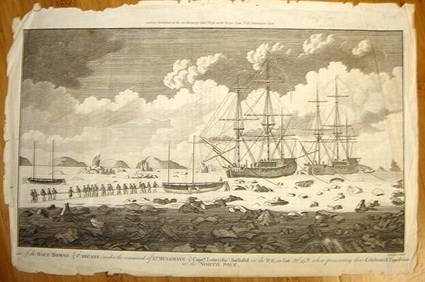
ALEXANDER HOGG ca1790 Engraving Captain Mulgrave Ships Ice Bound Cpt CookLuis Porretta Fine Arts4.3(10)See Sold PriceMar 02, 2024
Framed Space Age Rand McNally Map of Planets Poster, 1958PUBLIC SALE4.7(226)See Sold PriceMar 02, 2024
COLONIES FRANÇAISES AFRIQUE. Africa Sénégambie Madagascar. LEVASSEUR 1856 mapJasper524.5(9.9k)See Sold PriceFeb 28, 2024
AFRIQUE. Africa. Decorative antique map/carte by Victor LEVASSEUR 1856 oldJasper524.5(9.9k)See Sold PriceFeb 28, 2024
Early colonial Africa. Inset Madeira & Aden. SIDNEY HALL 1856 old antique mapJasper524.5(9.9k)See Sold PriceFeb 28, 2024
Northern & Southern Africa. Maghreb. Orange River Sovereignty. HALL 1856 mapJasper524.5(9.9k)See Sold PriceFeb 28, 2024
ANCIENT NORTH AFRICA Septentrionalis. Mauretania Tripolitana ARROWSMITH 1828 mapJasper524.5(9.9k)See Sold PriceFeb 28, 2024
AFRICA. French North Africa and Morocco 1907 old antique map plan chartJasper524.5(9.9k)See Sold PriceFeb 28, 2024
Perry, Matthew C. 1856 Large Map. Shah Bay, Lew Chew I. JapanAlbion Auctions4.6(341)See Sold PriceMar 01, 2024
Lot of 19 Military Prints - Swedish & British Arme Uniform - Schwerin leading battle - JuliusProverde Auctions4.3(3)See Sold PriceFeb 28, 2024
Set of 8 Antique Prints - Wilhelm Hecht - ??Junge Holländerin?? - after David Teniers II - 19thProverde Auctions4.3(3)See Sold PriceFeb 28, 2024
Carl Axel Magnus Lindman (1856 - 1928) - Set of 10 Botanical Prints - Caraway, Carum carvi -Proverde Auctions4.3(3)See Sold PriceFeb 28, 2024
Carl Axel Magnus Lindman (1856 - 1928) - Set of 10 Botanical Prints - Orchis militaris - TragopogonProverde Auctions4.3(3)See Sold PriceFeb 28, 2024
Carl Axel Magnus Lindman (1856 - 1928) - Set of 10 Botanical Prints - Viburnum opulus - SileneProverde Auctions4.3(3)See Sold PriceFeb 28, 2024
Carl Axel Magnus Lindman (1856 - 1928) - Set of 10 Botanical Prints - Burdock, Arctium lappa -Proverde Auctions4.3(3)See Sold PriceFeb 28, 2024
Carl Axel Magnus Lindman (1856 - 1928) - Set of 10 Botanical Prints - Cirsium oleraceum -Proverde Auctions4.3(3)See Sold PriceFeb 28, 2024
Carl Axel Magnus Lindman (1856 - 1928) - Set of 10 Botanical Prints - Consolida regalis - CampanulaProverde Auctions4.3(3)See Sold PriceFeb 28, 2024
Henri-Joseph Redouté - Large Folio Botanical Print - Plants in Egypt - Fagonia latifoliaProverde Auctions4.3(3)See Sold PriceFeb 28, 2024
Robert de Vaugondy - Map of Canada - Mer de l' Ouest or Sea of the West and a Northwest PassageProverde Auctions4.3(3)See Sold PriceFeb 28, 2024
Yuzaburo Kawanishi Signed Lmt Edition SilkscreenThe Benefit Shop Foundation Inc.4.3(2.9k)See Sold PriceMar 20, 2024