SoldBACON'S LARGE PRINT MAP OF LONDON AND SUBURBS, 1921Printed by G.W. Bacon & Co., London, sight size 28 x 35.5 inches, 38 x 43.5 inches overall. Professionally matted in archival material.See Sold Price
Bacon (George W.) London and SuburbsBacon (George W.) Large Scale Map of London and Suburbs,with 15 of the 18 double sheets, lacking 1 to 3, on a scale of 9 inches to a mile, showing every street name and property, from PentonviSee Sold Price
SoldLondon.- Bacon (George W., publisher) Bacon's New LargeLondon.- Bacon (George W., publisher) Bacon's New Large Scale Atlas of London and Suburbs with Supplementary Maps, Letterpress Descriptions and Alphabetical Index, complete with title, contents, threeSee Sold Price
SoldLondon.- Bacon (George W.) Bacon's New Large ScaleLondon.- Bacon (George W., publisher) Bacon's New Large Scale Atlas of London and Suburbs with Supplementary Maps, Letterpress Descriptions and Alphabetical Index, complete with title, contents, threeSee Sold Price
SoldLondon.- Bacon (George W.) New Large-Scale Ordnance***Please note, the description of this lot has changedLondon.- Bacon (George W.) New Large-Scale Ordnance Atlas of London & Suburbs with Supplementary Maps..., title, contents, two index maps, one foSee Sold Price
Sold1912 Bacon's Atlas of London and Suburbs Book1912 "Bacon's Large Scale Atlas of London and Suburbs" Hardcover edited by William Stanford.See Sold Price
SoldLondon.- Bacon (George W., publisher) Bacon's LargeLondon.- Bacon (George W., publisher) Bacon's Large Scale Atlas of London and Suburbs (revised edition), complete with title, contents, 7 maps of the home counties, and 46 double-page maps including 1See Sold Price
SoldLondon.- Stanford (William, editor) Bacon's Large ScaleLondon.- Stanford (William, editor) Bacon's Large Scale Atlas of London and Suburbs (Revised Edition), 61 double-page lithographed maps, original cloth, rubbed, slight bumping to corners and extremitiSee Sold Price
SoldBACON (G W & Co) Bacon's New Large Scale Ordance SurveyBACON (G W & Co) Bacon's New Large Scale Ordance Survey Atlas of London and Suburbs, 1880, large folio, double page index plan of London, and 25 coloured double page sheets including railways, all inSee Sold Price
SoldLondon.- Bacon (George W.) Bacon's New Large-ScaleLondon.- Bacon (George W.) Bacon's New Large-Scale Atlas of London and Suburbs..., complete with title, contents, three sets of index, key map of London, 25 double-page maps, six geological maps of LoSee Sold Price
SoldBacon (G.W., publisher) New Map of London, DividedBacon (G.W., publisher) New Map of London, Divided into Half Mile Squares & Circles,large map showing from Westbourne Park and Notting Hill to Bow and the Millwall Docks, lithograph, with someSee Sold Price
SoldLondon.- Newton (William) London Westminster SouthwarkLondon.- Newton (William) London Westminster Southwark as in Olden Times shewing the City and Suburbs, large wall map, lithograph printed in colours, several sheets conjoined, total sheet approx. 1375See Sold Price
Bacon's Gem Map of London and SuburbsTitle: Bacon's Gem Map of London and Suburbs Publication Date: 1910 ca. Publisher: G.W. BACON & CO. LTD. Size: 21x23.3 Street plan of greater London with its railways in red, folding into a 24mo clothSee Sold Price
SoldEarly 20th Century volume, ' Bacon's Large Scale AtlasEarly 20th Century volume, ' Bacon's Large Scale Atlas of London and Suburbs 'See Sold Price
SoldStanford's new large print map of the United States ofStanford's new large print map of the United States of North America London:1863. Showing boundary of seceded states.Scale of British miles 400Dimenstions 24" X 29 3/4"Inv.129See Sold Price
SoldBain (James, F.R.G.S.) - The Authentic Map Directory offourth edition, the last pre-war edition, complete with key map, large-scale street plan of London and suburbs in 173 sections, a plan of the City in 3 sections, with additional maps of parliamentary,See Sold Price
SoldLondon.- Bain (James, F.R.G.S.) The Authentic MapBain (James, F.R.G.S.) The Authentic Map Directory of London and Suburbs, Fourth edition, the last pre-war edition, complete with key map, large-scale street plan of London and suburbs in 173 sectionsSee Sold Price
SoldILN 1856 Large Ship Print & Map (Trimmed)"The Fleet of the Great Naval Review at Spithead" Together with "Picture Map of the Baltic Sea" on the reverse. Large Wood Engraving Published 1856, London for "The Illustrated London News" Folds as iSee Sold Price
Sold19th Century GW Bacon New Map of London LargeGW Bacon, "New Map of London," 19th century. This large engraved map of London is from Cassel's "Old and New London." Dimensions: Sight; height: 28 1/2 in x width: 39 1/2 in. Framed; height: 30 1/2 inSee Sold Price
Bacon's large scale plan of London, together with fiveBacon's large scale plan of London, together with five other maps of London (6) - Stock Ref:255-37See Sold Price
SoldStanford Library Map of London & its SuburbsStanford (Edward) Stanford's Library Map of London and its Suburbs,large scale map from Hornsey to South Norwood, and from Hammersmith to Greenwich, engraved map with original hand-colouring,See Sold Price
SoldStanford (Edward). Stanford's Library Map of London andStanford (Edward) Stanford's Library Map of London and its Suburbs, large engraved map with hand-colouring, on four sheets, each dissected and linen-backed with marbled ends and index map labels, eachSee Sold Price
SoldStanford's Library map of London. Kensington ChelseaReserve Reduced! TITLE/CONTENT OF MAP: 'Stanford's Library map of London and its suburbs [Sheets 9, 10, 13 & 14]' DATE PRINTED: 1877 IMAGE SIZE: Approx 65.0 x 82.0cm, 25.5 x 32.25 inches (Large); PleaSee Sold Price
SoldStanford's Library map of London. Marylebone NottingReserve Reduced! TITLE/CONTENT OF MAP: 'Stanford's Library map of London and its suburbs [Sheets 5, 6, 9 & 10]' DATE PRINTED: 1877 IMAGE SIZE: Approx 65.5 x 82.0cm, 25.75 x 32.25 inches (Large); PleasSee Sold Price
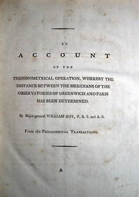
WILLIAM ROY Rare Navigation Book c1797 Trigonometry Between Paris & GreenwichLuis Porretta Fine Arts4.3(10)See Sold PriceMar 02, 2024
STRANG, William (1859-1921). The Doings of Death. [London: ...Potter & Potter Auctions4.6(545)See Sold PriceMar 07, 2024
D'Oyly (Calcutta, India) - Government House from St. Andrew's LibraryTrillium Antique Prints & Rare Books4.5(32)See Sold PriceFeb 24, 2024
D'Oyly (Calcutta, India) - Procession of the CurruckpoojaTrillium Antique Prints & Rare Books4.5(32)See Sold PriceFeb 24, 2024
Young Alligator, drawn in London October 1739. Shark. Catfish 1746 old printJasper524.5(9.9k)See Sold PriceFeb 28, 2024
CENTRAL AFRICA. French Congo German east British Angola Tanzania. BACON 1893 mapJasper524.5(9.9k)See Sold PriceFeb 28, 2024
AFRICA French Congo State Soudan Nile Delta Suez canal by GW BACON 1898 mapJasper524.5(9.9k)See Sold PriceFeb 28, 2024
Stanford, Edward 1901 Large Map. Sea of Marmara. TurkeyAlbion Auctions4.6(341)See Sold PriceMar 01, 2024
Stanford, Edward 1901 Large Map. Geological Map of the British IslesAlbion Auctions4.6(341)See Sold PriceMar 01, 2024
Stanford, Edward 1901 Large Map. Hydrographical Map of the British IslesAlbion Auctions4.6(341)See Sold PriceMar 01, 2024
Stanford, Edward 1901 Large Map. Stereographical Map of The British IslesAlbion Auctions4.6(341)See Sold PriceMar 01, 2024