SoldHENRICUS HONDIUS, MAP OF CHILE, CIRCA 1640Title: Map: Chile, Pub: 'Henricus Hondius, Date: Circa 1640, Medium: HC Engraving, Paper size: 17 1/2 x 22, Inscribed: Publisher identified within matrix, Condition: Good condition.See Sold Price
SoldTwo Continental Copperplate Maps, Hondius and afteras follows: Hondius, Henricus. Fossa Eugeniana (Amsterdam, circa 1640), showing the celebrated Spanish canal between the Rhine to the Meuse, French text en verso, outline color, presented in gold toneSee Sold Price
SoldHenricus Hondius map of ChileCartographer: Henricus Hondius Title: Chili Subject: Chile, South America Published: Amsterdam Date: c. 1630 Description: Map of Chile shows the Chonos Archipelago and Socorro Island in the Chilean SeSee Sold Price
SoldHenricus Hondius map of ChileCartographer: Henricus Hondius Title: Chili Subject: Chile, South America Published: Amsterdam Date: c. 1630 Description: Map of Chile shows the Chonos Archipelago and Socorro Island in the Chilean SeSee Sold Price
Henricus Hondius Gold Plate World Map (Circa 1630)Henricus Hondius c. 1630 world map on gold plate. Framed. Lettering Nova Totius Terrarum Orbis Geographica Ac Hydrographica Tabula. 44 x 66 cm (19.5 x 26 in), Frame: 80 x 97 cm (31.5 x 38 in)See Sold Price
MAP, Chile, HondiusChile. Henricus Hondius, Chili, from Atlas or a Geographicke Description of the Regions, Countries and Kingdoms of the World..., 1636 (published). Hand Color. Striking map covering the known coastal rSee Sold Price
SoldHondius map of Chile c.1630Title: Chili Author: Hondius, Henricus Description: Copper-engraved map, hand-colored. 36x48 cm. (14x19").Chile along the west coast of South America, with east at the top, sailing ships and sea monstSee Sold Price
SoldHand Colored 'Edenburg, Scotland' MapHand Colored 'Edenburg, Scotland' Map c.1640, Amsterdam, a new description of the shyres Lothian and Linlitqvo, mapmaker Timothy Pont, printer Henricus Hondius Height: 14.00 inches, Width: 21.00 incheSee Sold Price
MAP - Mid-Atlantic US. HondiusColonial Mid-Atlantic United States. Hondius/Schenk & Valck, Nova Virginiae Tabula, 1700 (circa). Hand Color. This graphic map is Henricus Hondius' version of Capt. John Smith's important map of 1612,See Sold Price
SoldHondius: Antique Map of Chile, 1635Title: Chili. Rare English edition of the Mercator-Hondius map of Chile Map maker: Henricus Hondius Place and Year: Amsterdam, c. 1635 Dimensions: 48. 3 x 36.8 cm (19 x 14.5 in) Technique: CopperplateSee Sold Price
Sold1633 Map Nova Virginiae Tabula - Henricus HondiusNova Virginiae Tabula map by Henricus Hondius (1597-1651). Undated, published circa 1633. This map is the 5th derivative of John Smith's 1612 map of Virginia, which was the first printed map of the ChSee Sold Price
SoldNova Virginiae TabulaHenricus Hondius (1573-1650). Engraved map with original hand color in full. Amsterdam, 1640. 20 x 23 1/2 inches sheet, 29 1/2 x 32 3/4 inches framed. This Map by Hondius was the first version of SmitSee Sold Price
MAP - Holy Land. HondiusHoly Land. Henricus Hondius, Situs Terrae Promissionis. S.S. Bibliorum Intelligentiam Exacte Aperiens per Chr. Adichom, 1633 (circa). Hand Color. Superb map of the Holy Land based on the cartography oSee Sold Price
SoldAntique Map, Willem Janszoon Blaeu, Nova VirginiaeWillem Janszoon Blaeu (Dutch, 1571-1638), "Nova Virginiae Tabula," circa 1640 (second state) after the 1629 Hondius plate, hand-colored copper engraved map (the coloring added later), plate: 14.75"h xSee Sold Price
SoldMercator, Gerard97. Mercator, Gerard.Le Diocese de Sarlat. Fine hand-colored engraved map, French text on verso. 19 x 24-1/2 inch double-page map, matted; scattered foxing. Amsterdam: Henricus Hondius, Circa 1630s [2See Sold Price
SoldHondius/Jansson map of Asia c.1640Heading: Author: Hondius, Henricus/ Jan Jansson Title: Asia Recens Summa Cura Delineata Place Published: Amsterdam Publisher: Date Published: c.1640 Description: Copper-engravedSee Sold Price
SoldEarly Map of Virginia afterJohn White [Nova Virginiae Tabula], by Willem Blaeu, Amsterdam, circa 1640, engraved after Jodocus Hondius' derivation of John White's 1612 map of Virginia, intricately detailed map of the ChesapeakeSee Sold Price
MAP, South Pole, HondiusMagnificent Early Map of the South Pole in Full Contemporary Color. South Pole. Henricus Hondius, Polus Antarcticus, from , 1639 (circa). Hand Color. This early map of the South Pole is considered oneSee Sold Price
Antique Venezuelan Map by HondiusMade by Henricus Hondius and Willem Janzoon Blaeu; titled "Venezuela cum parte Australi Novae Andalusiae"; published by Theatrum Orbis Terrarum sive Atlas Novus, Amsterdam, 1640-1655; measures approxiSee Sold Price
SoldMAP, Brazil, HondiusBrazil. Henricus Hondius, Accuratissima Brasiliae Tabula, 1639 (circa). Hand Color. Magnificent depiction of Brazil with north oriented to the right by a handsome compass rose. The map is inset with tSee Sold Price
MAPS - Polar. HondiusPolar. Henricus Hondius, [Lot of 2] Poli Arctici, et Circumiacentium Terrarum Descriptio Novissima [and] Polus Antarcticus, 1639 (circa). Black & White. A splendid pair of maps depicting the poles: PoSee Sold Price
SoldHENRICUS HONDIUS Map of the WorldHENRICUS HONDIUS Map of the World, hand colored, inscriptions to piece in Latin, label to reverse reads ‘Pincus Art Shop’, subject a map of the world accompanied by sea scenes, measures 17 x 21 1/See Sold Price
SoldHenricus Hondius map of PeruCartographer: Henricus Hondius Title: Peru Subject: Peru, South America Published: Amsterdam Date: c. 1630 Description: The map shows the territory of Peru, flanked to the north by the Equator and whaSee Sold Price
SoldHenricus Hondius map of BrazilCartographer: Henricus Hondius Title: Accuratissima Brasilia Tabula Subject: Brazil Published: Amsterdam Date: c. 1630 Description: Map includes insets of the Baia de Todos os Sanctos and the city ofSee Sold Price
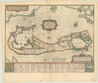
RARE 1638 HONDIUS MAP OF BERMUDA, FRAMEDThomaston Place Auction Galleries4.4(386)See Sold PriceFeb 24, 2024
Portfolio of 15 County Maps by Robert Morden (English 1650-1703)Nadeau's Auction Gallery4.7(401)See Sold PriceFeb 24, 2024
Eight Gulf, Mobile & Ohio Railroad Playing Card Decks - Alton Route Map and LogoRail & Road Auctions4.6(165)See Sold PriceMar 08, 2024
Antique Arts & Crafts Ebonized Oak Architect's Blueprint Flat File Cabinet, Circa 1900Liberty & 33rd Furniture Co.4.4(11)See Sold PriceFeb 27, 2024
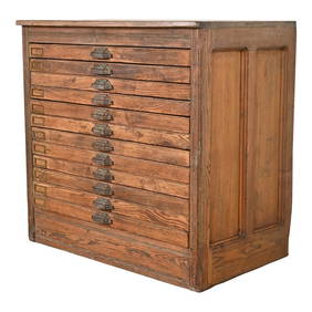
Antique Pine 12-Drawer Blueprint Flat File Cabinet by Hamilton, Circa 1900Liberty & 33rd Furniture Co.4.4(11)See Sold PriceFeb 27, 2024
Antique Arts & Crafts Oak Architect's Blueprint Flat File Cabinet, Circa 1900Liberty & 33rd Furniture Co.4.4(11)See Sold PriceFeb 27, 2024
Duval - Pair: Map of India & Map of MaldivesTrillium Antique Prints & Rare Books4.5(30)See Sold PriceFeb 24, 2024