ATLAS of ANTIENT GEOGRAPHY by SAMUEL BUTLER 1843John McInnis Auctioneers,LLC4.6(502)See Sold PriceFeb 24, 2024
18TH C. ANTIQUE MAP: FRENCH & INDIAN WAR, FRAMEDThomaston Place Auction Galleries4.4(386)See Sold PriceFeb 24, 2024
Rand McNally Railroad Map Cabinet w/ 21 Railroad MapsRail & Road Auctions4.6(165)See Sold PriceMar 08, 2024
Keith Haring - Ink on New York Map, Best Buddies, Inscribed, Signed, and DatedSapphire Auction Gallery4(67)See Sold PriceMar 02, 2024
LATE 17TH C. FRENCH MAP OF THE NEW WORLD BY ALEXIS-HUBERT JAILLOT (1632-1712)Thomaston Place Auction Galleries4.4(386)See Sold PriceFeb 24, 2024
Central Railroad of New Jersey Map of Sandy Hook Route-ca. 1903JM Hobby Supply and Railroad Artifact Auctions4.4(126)See Sold PriceFeb 24, 2024
Lot of Six Mixed Atlas Box Cars-HO Scale-New in BoxJM Hobby Supply and Railroad Artifact Auctions4.4(126)See Sold PriceFeb 25, 2024
Rand McNally/Santa Fe Railroad Map of Iowa-1912JM Hobby Supply and Railroad Artifact Auctions4.4(126)See Sold PriceFeb 24, 2024
NICOLAES VISSCHER (NETHERLANDS, 1618-1709) MAP OF THE NEW WORLDThomaston Place Auction Galleries4.4(386)See Sold PriceFeb 24, 2024
17TH C. WORLD MAP BY NICOLAES VISSCHER (NETHERLANDS, 1618-1709)Thomaston Place Auction Galleries4.4(386)See Sold PriceFeb 24, 2024
Lot of Six Mixed Atlas Cabooses-HO Scale-New in BoxJM Hobby Supply and Railroad Artifact Auctions4.4(126)See Sold PriceFeb 25, 2024
MAP, Chile, HondiusChile. Henricus Hondius, Chili, from Atlas or a Geographicke Description of the Regions, Countries and Kingdoms of the World..., 1636 (published). Hand Color. Striking map covering the known coastal rSee Sold Price
SoldHENRICUS HONDIUS, MAP OF CHILE, CIRCA 1640Title: Map: Chile, Pub: 'Henricus Hondius, Date: Circa 1640, Medium: HC Engraving, Paper size: 17 1/2 x 22, Inscribed: Publisher identified within matrix, Condition: Good condition.See Sold Price
SoldHenricus Hondius map of ChileCartographer: Henricus Hondius Title: Chili Subject: Chile, South America Published: Amsterdam Date: c. 1630 Description: Map of Chile shows the Chonos Archipelago and Socorro Island in the Chilean SeSee Sold Price
SoldHenricus Hondius map of ChileCartographer: Henricus Hondius Title: Chili Subject: Chile, South America Published: Amsterdam Date: c. 1630 Description: Map of Chile shows the Chonos Archipelago and Socorro Island in the Chilean SeSee Sold Price
SoldHondius map of Chile c.1630Title: Chili Author: Hondius, Henricus Description: Copper-engraved map, hand-colored. 36x48 cm. (14x19").Chile along the west coast of South America, with east at the top, sailing ships and sea monstSee Sold Price
SoldHondius: Antique Map of Chile, 1635Title: Chili. Rare English edition of the Mercator-Hondius map of Chile Map maker: Henricus Hondius Place and Year: Amsterdam, c. 1635 Dimensions: 48. 3 x 36.8 cm (19 x 14.5 in) Technique: CopperplateSee Sold Price
Sold17TH C. CONSTELLATION MAP, HONDIUSl.r. Henricus Hondius, 1661 HEMISPHAE ALIS COELI / RIIBORE ET TERRAE CASCENO PHIA 16.75 by 19 in. (sight)See Sold Price
SoldMap Chile Patagonia Argentina 1845 WalkerSOUTH AMERICA SHEET V PATAGONIA Published under the Superintendence of thew Society for the Diffusion of useful knowledge Beautiful big coloured map of Patagonia or modern day Argentina and Chile of 1See Sold Price
SoldMap Chile Paraguay Uruguay 1860REPUBLIQUES DES PROVINCES UNIES (OU LA PALATA) DU CHILI DU PARAGUAY ET DE L’URUGUAY Beautiful coloured map of 1860 circa featuring Chile, Paraguay and Uruguay. Decorated frame. Date: 1860 circaSee Sold Price
SoldMap, Hondius, Imperium Carolimagni, World Atlas, 1Framed period map ''Imperium Carolimagni'' from ''Le Nouveau Theatre du Monde,'' 1639, by or after Hendrick Hondius (Dutch, 1573-1649), overall: 19''h x 23''wSee Sold Price
SoldMap: Hondius "Terra di Lavoro Olim Campania Felix"[map] [ after] H. Hondius, "Terra di Lavoro olim Campania Felix", 17th / 18th C. hand-colored 15 1/4" h x 19 3/4" w = sheet (sight) 16 1/4" h x 20 3/4" w = frame CONDITION: Not examined out of frame;See Sold Price
Sold(MAP) HONDIUS, HENRICUS. Situe Terrae Promissionis. Ams(MAP) HONDIUS, HENRICUS Situs Terrae Promissionis. Amsterdam, n.d. [c. 1641] Engraved map with hand-coloring, depicting the Holy Land based on the cartography of Christian van Adriochom, with north orSee Sold Price
SoldAntique map Hondius Territorio PeruginoFramed hand-colored engraved map, Territorio Perugino, by Henrici Hondii (Henricus Hondius), plate: 15''h x 19.5''w, overall: 22''h x 25''wSee Sold Price
SoldHand Colored Copper Engraved Map HondiusCaert-Thresoor" Published by B. Langues, P. Bertius, Corn, Claecz, and Jodocus Hondius 3.5" x 4.75See Sold Price
MAP, Chile, SansonChile. N. Sanson/Mariette, Le Chili Divise en ses Treize Iurisdictions..., 1669 (dated). Hand Color. This important map of Chile, showing the Chicuito (Cuyo) provinces, is based on the descriptions ofSee Sold Price
MAP, Chile, HerreraChile. Antonio de Herrera y Tordesillas, Descripcion de la Provincia de Chile, 1622 (circa). Hand Color. Antonio de Herrera y Tordesillas was the official historian of Spain and the Indies. He compileSee Sold Price
MAP, Chile, BlaeuChile. Willem Blaeu, Chili, from Le Grand Atlas, 1663 (circa). Hand Color. This striking map covers the known coastal region of Chile from around Antofagasta in the north to Cabo Gallegos in the southSee Sold Price
SoldMap, Hondius, De ZypeHendrik Hondius (Dutch, 16th-17th century), "De Zype / Beemstre / De Purmer / De Wormer/ Caerte van Waterland," 1633, hand-colored copper engraved map, likely a later impression (18th/19th century) ofSee Sold Price
MAP - Chile. Gerritsz/De LaetChile. Hessel Gerritsz & Joannes de Laet, Chili, 1630 (published). Hand Color. This bold map covers Chili, from Puente de Vetes in the North to Cap de Diego Gallego in the south with north to the leftSee Sold Price
Big Map Chile Paraguay Uruguay Patagonia hand colouredReserve Reduced! Title/Content of Map: Big Map Chile Paraguay Uruguay Patagonia hand coloured 1870 Vuillemin Bellier Copper etching Date Printed: 1870 Cartographer: Alexandre Vuillemin, P. Bellier MatSee Sold Price
SoldMap Chile La Plata part Bolivia 1840 HallCHILI LA PLATA AND PART OF BOLIVIA Beautiful big map of 1840 circa featuring Chile, La Plata and part of Bolivia Date: 1840 circa Author: S. Hall Technique: Copper etching Leaf Dimension: 44x29,5 cm (See Sold Price
MAP, Chile, Gerritsz/De LaetChile. Hessel Gerritsz & Joannes de Laet, Chili, from Novus Orbis seu descriptionis Indiae Occidentalis, 1633 (circa). Hand Color. This bold map covers Chili, from Puente de Vetes in the North to CapSee Sold Price
MAP, Chile, SansonChile. N. Sanson/Mariette, Le Chili. Tire de Alf de Oualle de la C.d.I. et Divise en Treize Iurisdictions, 1662 (circa). Hand Color. Fine small version of Sanson's important map of Chili showing the CSee Sold Price
Coloured map Chile, Paraguay and Uruguay 1860 CopperReserve Reduced! Title/Content of Map: Coloured map Chile, Paraguay and Uruguay 1860 Copper etching Date Printed: 1860 Cartographer: Material/Medium: Copper etching Size: Leaf Dimension: 40,5x28,5 cmSee Sold Price
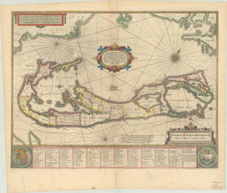
RARE 1638 HONDIUS MAP OF BERMUDA, FRAMEDThomaston Place Auction Galleries4.4(386)See Sold PriceFeb 24, 2024
18TH C. ANTIQUE MAP: FRENCH & INDIAN WAR, FRAMEDThomaston Place Auction Galleries4.4(386)See Sold PriceFeb 24, 2024
Keith Haring - Ink on New York Map, Best Buddies, Inscribed, Signed, and DatedSapphire Auction Gallery4(67)See Sold PriceMar 02, 2024
Rand McNally Railroad Map Cabinet w/ 21 Railroad MapsRail & Road Auctions4.6(165)See Sold PriceMar 08, 2024
Putnam - First Map of the State of Ohio by Rufus PutnamTrillium Antique Prints & Rare Books4.5(30)See Sold PriceFeb 24, 2024
1760 MAP CARTE PARTICULIERE DE L'ISLE DE JUAN FERNANDES antique Robinson CrusoeJasper524.5(9.8k)See Sold PriceFeb 27, 2024
1822 MAP of CHILI GEOGRAPHICAL STATISTICAL HISTORICAL antique 17.5x 22" CHILEJasper524.5(9.8k)See Sold PriceFeb 27, 2024
1636 MAP of SWITZERLAND DAS WIFISPURGERGOU antique 15 by 19"Jasper524.5(9.8k)See Sold PriceFeb 27, 2024
Rare 19thc Colton Map, Argentine Republic, Chile, Uruguay, PataguayConnoisseur Auctions4(333)See Sold PriceMar 16, 2024