GROUP OF NINE CHICAGO LITHOGRAPHIC MAPS.GROUP OF NINE CHICAGO LITHOGRAPHIC MAPS. Large folio, loose hand colored sheets, E. Robinson, 1886 22.75" x 32.75"See Sold Price
SoldMaps of Different Island Groups (7) (63208)1) Samoan Islands, Ca. 1900. Lithographic color and cartography by Geo. F Cram, Chicago. Approximately 14.5" x 12." 2) Philippine Islands, ca. 1900. Cartography and color by lithography by Geo. Cram,See Sold Price
Maps of Different Island Groups (7) 632081) Samoan Islands, Ca. 1900. Lithographic color and cartography by Geo. F Cram, Chicago. Approximately 14.5" x 12." 2) Philippine Islands, ca. 1900. Cartography and color by lithography by Geo. Cram,See Sold Price
SoldGrp: 9 Maps of New York City 18th-Early 20th c.Group of nine maps of New York City, dating from the 18th to early 20th century. By cartographers including John Montresor (1736-1799). Additionally includes a lovely 1704 map of the city featuring thSee Sold Price
SoldGrp: 9 Maps of ItalyGroup of nine maps of Italy. Includes a map of Italy and Corsica by Thomas Kitchin. Partially colored map of Italy and Sicily "Itallae Antiqvae Pars Meridionalis." A colored map of Northern Italy "ItaSee Sold Price
SoldGrp: 9 Maps of SpainGroup of nine maps of Spain. A large map of Granada. A colored map of Spain and part of North Africa with a detail insert of the Harbour of Port Mahon by Emmanuel Bowen. A large map of the coasts of SSee Sold Price
SoldGrp: 9 Maps of FranceGroup of nine maps of France and other parts of Northern Europe. Hand Colored Map of the Netherlands "Les Provinces Unies des Pays-Bas" 1672; Nicolas Sanson (1600-1667) Hand Colored Map of "Les Deux BSee Sold Price
Sold(MAP, ITALY) A group of 9 maps.(MAP, ITALY) A group of nine maps of Italy. Size of largest 13 1/2 x 17 inches.See Sold Price
SoldGrp: 9 Maps of the Americas Africa and the WorldGroup of nine maps of various regions of the world. Includes J. Warr Jr. hand colored map of the United States, Philadelphia, ca. 1822; Mathew Carey (1760-1839) map of Africa "Africa from the best AutSee Sold Price
SoldGrp: 9 Maps of South AmericaGroup of nine maps of South America. Includes Alexander Hogg (1778-1824), "The North Side of the largest of Queen Charloue's Islands as it appeared running along shore to the Westward" London, ca. 179See Sold Price
SoldGroup of nine Johnson's Maps, to include Indiana, NorthGroup of nine Johnson's Maps, to include Indiana, North America, Ohio Missouri, Europe, Nebraska, Wisconsin, World, and Arkansas, sight size 17" x 23 1/2". Provenance: Credit Suisse Americana CollectiSee Sold Price
SoldToys and Novelties Magazine. Group of Nine Issues.Toys and Novelties Magazine. Group of Nine Issues. Chicago, 1946—50. Original pictorial wraps. Eight issues of the magazine (4to) and one buyers’ guide (8vo). Copiously illustrated, including coloSee Sold Price
SoldGroup of Nine Matching Framed MapsGroup lot of nine framed maps all with matching gilt frames with burgundy mat board and gilt inner frame and UV protective glass. including: Roma, Helvetia, Hereford shire, Persia, Asia, The World, PaSee Sold Price
Sold(CHICAGO, MAPS) A group of two nineteenth-century(CHICAGO, MAPS) A group of two maps of Chicago, comprising Railway Map of Chicago, by Rand McNally & Co., Chicago, 1895, and Chicago City Street Guide, by Samuel Augustus Mitchell, Jr., Philadelphia,See Sold Price
Sold(CHICAGO, MAPS) A group of 12 maps of Chicago and(CHICAGO, MAPS) A collection of 12 maps of Chicago and two maps of Saint Louis, including Map G. No. 52. Chicago Harbor and Bar, Illinois. From Survey made in April 1857 under the Direction of BrevetSee Sold Price
SoldMaps and Map Making (9) BooksGroup of nine books of maps and map making. Includes: 1) Two 1978 editions. The Compleat Plattmaker by Norman Thrower. 2) Proceedings of the Vinland Map Conference by Washburn. 1971. 3) American MapsSee Sold Price
SoldDwight D. Eisenhower - 1948 & 1952 ButtonsGroup of nine celluloid and lithographic portrait, cartoon, and volunteer buttons [Sizes from 1-1/4" diameter to 2-3/4" wide oval. Features a 1-1/4" smiling portrait pinback button with imprinted bordSee Sold Price
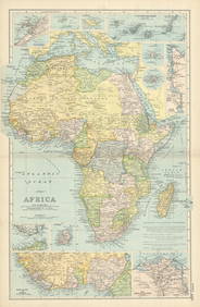
[Maps & Atlases], Group of Six Engraved and[Maps & Atlases] Group of Six Engraved and Lithographic Maps Primarily of Europe and the British Isles Braun, Georg, and Franz Hogenberg "Cestria Vulgo Chester" (Cologne, after 1581). Uncolored engravSee Sold Price
SoldA Small Group of Maps of BelgiumA Small Group of Maps of Belgium,nine engraved maps, town plans and battle plans, including Menin, Flanders, and the battles of Leuze and Steenkerke, by de Fer, van Loon, Mortier and others,See Sold Price
A Small Group of Maps of BelgiumA Small Group of Maps of Belgium,nine engraved maps, town plans and battle plans, including Menin, Flanders, and the battles of Leuze and Steenkerke, by de Fer, van Loon, Mortier and others,See Sold Price
SoldA Group of 13 maps of Chicago and Illinois, comprising:A Group of 13 maps of Chicago and Illinois, comprising: Map of Illinois. N.p.:N.d. 33 x 25.5 inches. -- Pictorial Map of Chicago. N.p.: N.d. 44 x 31.5 inches. -- Map of Chicago; [W.1/2 of S.E.1/4 SectSee Sold Price
SoldA group of 4 maps of Chicago, comprising:A group of 4 maps of Chicago, comprising: New Commercial Atlas Map of Chicago District. Chicago: Rand McNally & Company. N.d. -- RICE, H.E. Rice's Pathfinder Map. N.p.: N.d. -- Standard Map of ChicagoSee Sold Price
SoldA group of 5 maps of Chicago streets, comprising:A group of 5 maps of Chicago streets, comprising: E. 1/2 of S.W 1/4 Section 8.39.14. N.P.: N.d. 31 x 40 3/4 in. -- W. 1/2 of N.W. 1/4 Section 4.39.14. Butterfields Add. N.p: N.d. 31 x 40 3/4 in. -- E.See Sold Price
Sold[MAPS OF CHICAGO AND ILLINOIS]. A group of 4 maps and[MAPS OF CHICAGO AND ILLINOIS]. A group of 4 maps and bird's-eye views of Chicago, comprising: MITCHELL. Augustus. Chicago. Pennsylvania, 1867. Engraved map of Chicago, hand-colored, image 13 1/4 x 11See Sold Price
A Group of Nine Books: Tribal Rugs, James Opie; The Eastern Carpet in the Western World, HaywordNazmiyal Auctions4.4(36)See Sold PriceFeb 26, 2024
Group of Nine Books: Handbook of Embroidery; The Book of Stitches, Ellen T. Masters; The Lady'sNazmiyal Auctions4.4(36)See Sold PriceFeb 26, 2024
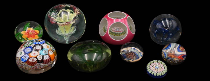
Group of Nine Early Signed Glass PaperweightsNadeau's Auction Gallery4.7(410)See Sold PriceFeb 24, 2024
Group of Ten Railroad Photographs, Maps, and Prints - New Jersey, Long Island, and New YorkRail & Road Auctions4.6(165)See Sold PriceMar 07, 2024
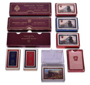
Nine Pennsylvania Railroad Playing Card Decks - The American, Liberty Limited, Broadway Limited, andRail & Road Auctions4.6(165)See Sold PriceMar 08, 2024
Eighteen Elgin Joliet & Eastern Railroad Chicago Outer Belt Playing Card DecksRail & Road Auctions4.6(165)See Sold PriceMar 08, 2024
[CHICAGO]. Group of 21 Medals or Pins for Sporting or Music...Potter & Potter Auctions4.6(550)See Sold PriceMar 07, 2024
[CHICAGO]. Group of Dozens of Advertising Items, including:...Potter & Potter Auctions4.6(550)See Sold PriceMar 07, 2024
[CHICAGO]. Group of Dozens of Advertising Items, including:...Potter & Potter Auctions4.6(550)See Sold PriceMar 07, 2024
[CIVIL WAR]. Group of Nine Newspapers, Six Confederate and ...Potter & Potter Auctions4.6(550)See Sold PriceMar 07, 2024
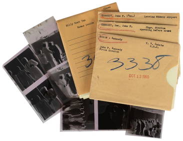
[KENNEDY, John F. (1917-1963) and NIXON, Richard M (1913-19...Potter & Potter Auctions4.6(550)See Sold PriceMar 07, 2024
[LITHOGRAPHY]. [TOBACCO]. Group of Nine Inner Cigar Box Lab...Potter & Potter Auctions4.6(550)See Sold PriceMar 07, 2024
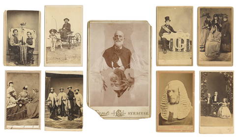
Group of Nine Cabinet Cards of Assorted Sub...Potter & Potter Auctions4.6(550)See Sold PriceMar 07, 2024
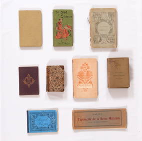
[CHICAGO]. Group of Nine Books Related to the Chicago Tribu...Potter & Potter Auctions4.6(550)See Sold PriceMar 07, 2024
[BASEBALL]. Group of Nine Issues of “Beisbol Semanario Espe...Potter & Potter Auctions4.6(550)See Sold PriceMar 07, 2024
CENTRAL AFRICA. Tanzania, Kenya, Angola, Zambia, Congo, Mozambique 1903 mapJasper524.5(9.9k)See Sold PriceFeb 28, 2024
AFRICA French Congo State Soudan Nile Delta Suez canal by GW BACON 1898 mapJasper524.5(9.9k)See Sold PriceFeb 28, 2024


![[Maps & Atlases], Group of Six Engraved and (1 of 6)](https://p1.liveauctioneers.com/65/159076/80333185_1_x.jpg?height=282&quality=70&version=1578427354)


![[MAPS OF CHICAGO AND ILLINOIS]. A group of 4 maps and (1 of 3)](https://p1.liveauctioneers.com/197/128324/65283842_1_x.jpg?height=282&quality=70&version=1537814359)


![[CHICAGO]. Group of 21 Medals or Pins for Sporting or Music... (1 of 1)](https://p1.liveauctioneers.com/928/318880/171360929_1_x.jpg?height=282&quality=70&version=1707501302)
![[CHICAGO]. Group of Dozens of Advertising Items, including:... (1 of 1)](https://p1.liveauctioneers.com/928/318880/171360930_1_x.jpg?height=282&quality=70&version=1707501302)
![[CHICAGO]. Group of Dozens of Advertising Items, including:... (1 of 1)](https://p1.liveauctioneers.com/928/318880/171360931_1_x.jpg?height=282&quality=70&version=1707501302)
![[CIVIL WAR]. Group of Nine Newspapers, Six Confederate and ... (1 of 1)](https://p1.liveauctioneers.com/928/318880/171360938_1_x.jpg?height=282&quality=70&version=1707501302)
![[LITHOGRAPHY]. [TOBACCO]. Group of Nine Inner Cigar Box Lab... (1 of 1)](https://p1.liveauctioneers.com/928/318880/171361091_1_x.jpg?height=282&quality=70&version=1707501302)
![[ACROBATS]. Group of Nine CDV Port... (1 of 1)](https://p1.liveauctioneers.com/928/318880/171361225_1_x.jpg?height=282&quality=70&version=1707501302)
![[CHICAGO]. Group of Nine Books Related to the Chicago Tribu... (1 of 1)](https://p1.liveauctioneers.com/928/318880/171361259_1_x.jpg?height=282&quality=70&version=1707501302)
![[BASEBALL]. Group of Nine Issues of “Beisbol Semanario Espe... (1 of 1)](https://p1.liveauctioneers.com/928/318880/171361349_1_x.jpg?height=282&quality=70&version=1707501302)