ATLAS of ANTIENT GEOGRAPHY by SAMUEL BUTLER 1843John McInnis Auctioneers,LLC4.6(502)See Sold PriceFeb 24, 2024
18TH C. ANTIQUE MAP: FRENCH & INDIAN WAR, FRAMEDThomaston Place Auction Galleries4.4(386)See Sold PriceFeb 24, 2024
Rand McNally Railroad Map Cabinet w/ 21 Railroad MapsRail & Road Auctions4.6(165)See Sold PriceMar 08, 2024
Keith Haring - Ink on New York Map, Best Buddies, Inscribed, Signed, and DatedSapphire Auction Gallery4(67)See Sold PriceMar 02, 2024
LATE 17TH C. FRENCH MAP OF THE NEW WORLD BY ALEXIS-HUBERT JAILLOT (1632-1712)Thomaston Place Auction Galleries4.4(386)See Sold PriceFeb 24, 2024
Central Railroad of New Jersey Map of Sandy Hook Route-ca. 1903JM Hobby Supply and Railroad Artifact Auctions4.4(126)See Sold PriceFeb 24, 2024
Lot of Six Mixed Atlas Box Cars-HO Scale-New in BoxJM Hobby Supply and Railroad Artifact Auctions4.4(126)See Sold PriceFeb 25, 2024
Rand McNally/Santa Fe Railroad Map of Iowa-1912JM Hobby Supply and Railroad Artifact Auctions4.4(126)See Sold PriceFeb 24, 2024
NICOLAES VISSCHER (NETHERLANDS, 1618-1709) MAP OF THE NEW WORLDThomaston Place Auction Galleries4.4(386)See Sold PriceFeb 24, 2024
17TH C. WORLD MAP BY NICOLAES VISSCHER (NETHERLANDS, 1618-1709)Thomaston Place Auction Galleries4.4(386)See Sold PriceFeb 24, 2024
Lot of Six Mixed Atlas Cabooses-HO Scale-New in BoxJM Hobby Supply and Railroad Artifact Auctions4.4(126)See Sold PriceFeb 25, 2024
SoldMaps of Different Island Groups (7) (63208)1) Samoan Islands, Ca. 1900. Lithographic color and cartography by Geo. F Cram, Chicago. Approximately 14.5" x 12." 2) Philippine Islands, ca. 1900. Cartography and color by lithography by Geo. Cram,See Sold Price
Maps of Different Island Groups (7) 632081) Samoan Islands, Ca. 1900. Lithographic color and cartography by Geo. F Cram, Chicago. Approximately 14.5" x 12." 2) Philippine Islands, ca. 1900. Cartography and color by lithography by Geo. Cram,See Sold Price
SoldBritish Caribbean Territories, Eastern Group, 19532nd January, 1959. $1, P-7c. Unlisted Specimen Banknote, red on m/c with portrait of Queen Elizabeth on right and map on left, back with Arms of the different islands of the Eastern Group. Serial # J3See Sold Price
SoldGroup of 7 vintage Rock Island Lines flatwareDifferent patterns and manufacturers. Largest piece is 9.75 inches.See Sold Price
SoldGroup of 7 Egyptian AmuletsEgypt; Ancient to modern. Group of 7 composition amulets representing different Deities. One with silver mount. These have not been researched but are part of an old Rhode Island Collection. Largest;See Sold Price
SoldMoll (Herman) - The South Part of Africa and the Islandengraved map with original hand-colouirng in outline, 210 x 280mm., c.1700; with a mixed group of 7 other small maps by or after Bertius, Mallet, John Rapkin and others (8)See Sold Price
SoldGroup of 9 MapsLot of nine antique maps. 1746 Bellin map of Cape Verde island. H 10" W 14". 1574 Sebastion Munster map from 'Cosmographia Universalis'. H 12-5/8" W 7-1/8". 1598 Sebastion Munster map of Ireland, ScotSee Sold Price
Valentyn (F.) views in the Dutch East IndiesValentyn (Fran‡ois) a group of maps and views in the Dutch East Indies,24 views on 7 sheets, including 3 plans and a separate map of Amboina and Boero islands, most detailed views of coastal sSee Sold Price
Nautical Map / Sea Chart, #222 Greenwich Point to NewDescription: Nautical Map / Sea Chart, North Shore of Long Island Greenwich Pt to New Rochelle, 6th ed June 21/39 revised 11/7/60; Folded; Shipping: $20; different rate to California, Alaska, Hawaii &See Sold Price
Nautical Map / Sea Chart, #222 Greenwich Point to NewDescription: Nautical Map / Sea Chart, North Shore of Long Island Greenwich Pt to New Rochelle, 6th ed June 21/39 revised 11/7/60; Folded; Shipping: $20; different rate to California, Alaska, Hawaii &See Sold Price
Nautical Map / Sea Chart, #222 Greenwich Point to NewDescription: Nautical Map / Sea Chart, North Shore of Long Island Greenwich Pt to New Rochelle, 6th ed June 21/39 revised 11/7/60; Folded; Shipping: $20; different rate to California, Alaska, Hawaii &See Sold Price
Nautical Map / Sea Chart, #222 Greenwich Point to NewDescription: Nautical Map / Sea Chart, North Shore of Long Island Greenwich Pt to New Rochelle, 6th ed June 21/39 revised 11/7/60; Folded; Shipping: $20; different rate to California, Alaska, Hawaii &See Sold Price
Nautical Map / Sea Chart, #222 Greenwich Point to NewDescription: Nautical Map / Sea Chart, North Shore of Long Island Greenwich Pt to New Rochelle, 6th ed June 21/39 revised 11/7/60; Folded; Shipping: $20; different rate to California, Alaska, Hawaii &See Sold Price
Nautical Map / Sea Chart, #222 Greenwich Point to NewDescription: Nautical Map / Sea Chart, North Shore of Long Island Greenwich Pt to New Rochelle, 6th ed June 21/39 revised 11/7/60; Folded; Shipping: $20; different rate to California, Alaska, Hawaii &See Sold Price
Nautical Map / Sea Chart, #222 Greenwich Point to NewDescription: Nautical Map / Sea Chart, North Shore of Long Island Greenwich Pt to New Rochelle, 6th ed June 21/39 revised 11/7/60; Folded; Shipping: $20; different rate to California, Alaska, Hawaii &See Sold Price
Nautical Map / Sea Chart, #222 Greenwich Point to NewDescription: Nautical Map / Sea Chart, North Shore of Long Island Greenwich Pt to New Rochelle, 6th ed June 21/39 revised 11/7/60; Folded; Shipping: $20; different rate to California, Alaska, Hawaii &See Sold Price
Northern California USGS Folio Group (115322)Lot of 7 different. Included: Downieville (No. 37, 1897), Motherlode (No. 63, 1900), Bidwell Bar (No. 43, 1898), Marysville (No. 17, 1895), Jackson (No. 11, 1894), Colfax (No. 66), and Smartsville (NoSee Sold Price
SoldPair of Royal Vienna Style Porcelain LampsPair of Royal Vienna Style Porcelain Lamps featuring assortment of different groups. Measures - 7 3/8" deep x 32" high x 9 1/4" wide.See Sold Price
SoldPair of Royal Vienna Style Porcelain LampsPair of Royal Vienna Style Porcelain Lamps featuring assortment of different groups. Measures - 7 3/8" deep x 32" high x 9 1/4" wide.See Sold Price
Pair of Royal Vienna Style Porcelain LampsPair of Royal Vienna Style Porcelain Lamps featuring assortment of different groups. Measures - 7 3/8" deep x 32" high x 9 1/4" wide.See Sold Price
Pair of Royal Vienna Style Porcelain LampsPair of Royal Vienna Style Porcelain Lamps featuring assortment of different groups. Measures - 7 3/8" deep x 32" high x 9 1/4" wide.See Sold Price
SoldRhode Island Industrial Certificate Group.Rhode Island Industrial Group. [7] 1-2) Providence Saw 1869-71. 3-7) Union Machine 1887-1890. Three receipts are also included. VF-VF+. The Providence Saw was founded by J.MasoSee Sold Price
Mitchell: Map of Oceanica & Island Groups, 1867Map: Map of Oceanica, Exhibiting its Various Divisions, Island Groups &c. Cartographer: S. A. Mitchell Place & Date: Philadelphia / 1867/1870 Size: 13 1/4" x 10 3/4" The beautifully detailed and colorSee Sold Price
SoldMAPS; a group of 7 vintage maps; circa 1700-1890.MAPS; a group of 7 vintage maps; circa 1700-1890. All beautifully framed and matted. From 6 inches x 4.5 inches up to 14 inches x 19.25 inches. Estimate $300-$500See Sold Price
EARLY 18TH C. DUTCH CHART OF PACIFIC OCEAN BY FREDERIK DE WIT (1629-1706) WITH CALIFORNIA AS ANThomaston Place Auction Galleries4.4(386)See Sold PriceFeb 24, 2024
Group of Ten Railroad Photographs, Maps, and Prints - New Jersey, Long Island, and New YorkRail & Road Auctions4.6(165)See Sold PriceMar 07, 2024
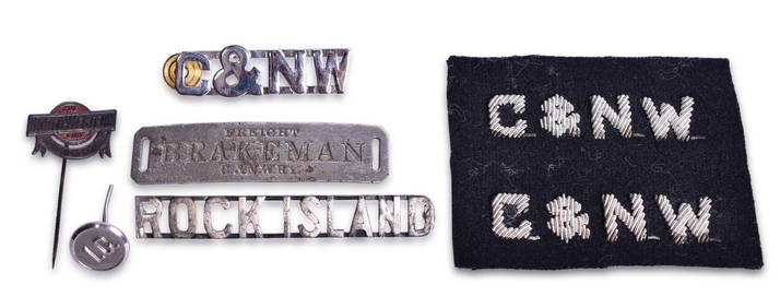
Group of Railroad Uniform Pins, Cap Badge, Patches, and Button - Chicago & North Western, RockRail & Road Auctions4.6(165)See Sold PriceMar 07, 2024
Art Deco Foil Backed Eglomise SilhouettesJudd's Auction Gallery, Inc. 4.6(164)See Sold PriceFeb 25, 2024
Group of 7 Standard, Pure, Gulf, Texaco Service Station MapsCheck the Oil Promotions, LLC4.6(275)See Sold PriceMar 03, 2024
1764 Bellin Map of Lesser Antilles Northern Portion -- Petites Antilles ou Isles du Vent 3e. Partie.Jasper524.5(9.8k)See Sold PriceFeb 27, 2024
1834 Malte-Brun Map of the Caribbean -- West India IslandsJasper524.5(9.8k)See Sold PriceFeb 27, 2024
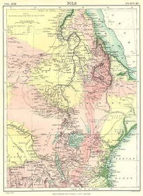
NILE VALLEY. Sudan Tanzania Ethiopia Uganda Lake Victoria. Britannica. 1898 mapJasper524.5(9.8k)See Sold PriceFeb 28, 2024
WEST AFRICA. Guinea. Nigeria Ghana Benin Togo Sierra Leone. MALLET 1683 mapJasper524.5(9.8k)See Sold PriceFeb 28, 2024
Plan de la Baye & Isle d'Arguim'. Mauritania. Arguin island. BELLIN 1746 mapJasper524.5(9.8k)See Sold PriceFeb 28, 2024
Coste d’Afrique…' Guinea-Bissau & Bissagos archipelago. BELLIN 1746 old mapJasper524.5(9.8k)See Sold PriceFeb 28, 2024
Central Africa. Map showing great forest traversed by Mr Stanley, 1890Jasper524.5(9.8k)See Sold PriceFeb 28, 2024
AFRICAN ISLANDS.Mauritius Madagascar Madeira Canaries St Helena 1897 old mapJasper524.5(9.8k)See Sold PriceFeb 28, 2024
Guinea-Bissau. Kazegut women. Galinhas island, Bissagos archipelago 1746 printJasper524.5(9.8k)See Sold PriceFeb 28, 2024
Group Lot of 9 Antique Russian Silver ItemsWorld Auction Gallery LLC4.7(261)See Sold PriceMar 10, 2024
7 Sterling Silver Items Including Georg JensenWorld Auction Gallery LLC4.7(261)See Sold PriceMar 10, 2024
Group of 7 Beer Advertising Tap HandlesMatthew Bullock Auctioneers4.7(1.8k)See Sold PriceMar 17, 2024