Sold(CHICAGO, MAPS) A group of 12 maps of Chicago and(CHICAGO, MAPS) A collection of 12 maps of Chicago and two maps of Saint Louis, including Map G. No. 52. Chicago Harbor and Bar, Illinois. From Survey made in April 1857 under the Direction of BrevetSee Sold Price
Sold(CHICAGO, MAPS) A group of two nineteenth-century(CHICAGO, MAPS) A group of two maps of Chicago, comprising Railway Map of Chicago, by Rand McNally & Co., Chicago, 1895, and Chicago City Street Guide, by Samuel Augustus Mitchell, Jr., Philadelphia,See Sold Price
SoldA Group of 13 maps of Chicago and Illinois, comprising:A Group of 13 maps of Chicago and Illinois, comprising: Map of Illinois. N.p.:N.d. 33 x 25.5 inches. -- Pictorial Map of Chicago. N.p.: N.d. 44 x 31.5 inches. -- Map of Chicago; [W.1/2 of S.E.1/4 SectSee Sold Price
SoldA group of 4 maps of Chicago, comprising:A group of 4 maps of Chicago, comprising: New Commercial Atlas Map of Chicago District. Chicago: Rand McNally & Company. N.d. -- RICE, H.E. Rice's Pathfinder Map. N.p.: N.d. -- Standard Map of ChicagoSee Sold Price
SoldA group of 5 maps of Chicago streets, comprising:A group of 5 maps of Chicago streets, comprising: E. 1/2 of S.W 1/4 Section 8.39.14. N.P.: N.d. 31 x 40 3/4 in. -- W. 1/2 of N.W. 1/4 Section 4.39.14. Butterfields Add. N.p: N.d. 31 x 40 3/4 in. -- E.See Sold Price
GROUP OF NINE CHICAGO LITHOGRAPHIC MAPS.GROUP OF NINE CHICAGO LITHOGRAPHIC MAPS. Large folio, loose hand colored sheets, E. Robinson, 1886 22.75" x 32.75"See Sold Price
1899 Map of ChicagoTitle: 1899 Map of Chicago Medium: Ink on Paper Dimensions: 12"X15" Map of the city of Chicago dated 1899. Rather rare. Part of the 1899 in the National Standard Atlas of the World. Published by the FSee Sold Price
Sold[MAPS OF CHICAGO AND ILLINOIS]. A group of 4 maps and[MAPS OF CHICAGO AND ILLINOIS]. A group of 4 maps and bird's-eye views of Chicago, comprising: MITCHELL. Augustus. Chicago. Pennsylvania, 1867. Engraved map of Chicago, hand-colored, image 13 1/4 x 11See Sold Price
Sold1899 Map of ChicagoAuthor: Title: 1899 Map of Chicago Medium: Ink on Paper Dimensions: 12"X15" Description: Map of the city of Chicago dated 1899. Rather rare. Part of the 1899 in the National Standard Atlas of the WorlSee Sold Price
Sold(CHICAGO) A group of 12 items pertaining to Chicago, in(CHICAGO) A group of 12 items pertaining to Chicago, including engravings, newspapers, maps and atlases.See Sold Price
Sold(CHICAGO, MAPS) MILLER AND CO. Map of Lots at Chic(CHICAGO, MAPS) MILLER AND CO. LITHOGRAPHY Map of Lots at Chicago for Sale by Franklin & Jenkins on Friday 8th of May, 1835, at 12 O'Clock at the Merchant's Exchange. (New York: Miller & Co., 1835). TSee Sold Price
SoldMAP OF CHICAGO, 1937, SIGHT CA. H 16", W 12"MAP OF CHICAGO, 1937, SIGHT CA. H 16", W 12" :Framed.See Sold Price
Sold*GROUP OF CHICAGO MEMORABILIA"Carlson's Chicago Street and Transportation Guide", historical map of Illinois, 1936 Chicago land map, etc.See Sold Price
SoldMaps of Different Island Groups (7) (63208)1) Samoan Islands, Ca. 1900. Lithographic color and cartography by Geo. F Cram, Chicago. Approximately 14.5" x 12." 2) Philippine Islands, ca. 1900. Cartography and color by lithography by Geo. Cram,See Sold Price
Maps of Different Island Groups (7) 632081) Samoan Islands, Ca. 1900. Lithographic color and cartography by Geo. F Cram, Chicago. Approximately 14.5" x 12." 2) Philippine Islands, ca. 1900. Cartography and color by lithography by Geo. Cram,See Sold Price
SoldA Group of Two Maps, Height of first 32 x width 39A Group of Two Maps, depicting Chicago and the Northeast United States, each framed. Height of first 32 x width 39 inches framed.See Sold Price
Sold(MAP) A group of 12 engraved maps.(MAP) A group of 12 engraved maps, including two with hand-coloring. Size of largest 10 x 14 inches.See Sold Price
SoldCOLTON, G. W. and C. B. Group of 12 maps.COLTON, G. W. and C. B. Group of 12 maps. Standard size sheets as issued, all but one hand-colored; condition generally fine, several with minor dampstaining. New York, vd Canada West or Upper Canada.See Sold Price
SoldChicago White Sox Press, Wire, Publicity PhotosA group of 12 Chicago White Sox vintage wire, press and/or publicity photos. They measure approximately 8-in. x 10-in. Condition and ages vary. Provenance: Mark Rucker collection. We ship most items iSee Sold Price
Sold1955 Bowman Baseball White Sox & Cubs1955 Bowman Baseball Card Lot; group of (12) Chicago White Sox and (7) Chicago Cubs ; Cubs include 7, 8, 52, 87, 137, 181, 223; Sox include 26, 34, 85, 86, 116, 117, 151, 173, 174 (Lollar), 213 (Kell)See Sold Price
SoldOfficial map Chicago Zoological Park Brookfield nearTitle/Content of Map: Official map Chicago Zoological Park Brookfield near Riverside Date: 1930 ca. Cartographer: Size: 13.25X18 Color pictorial plan of the zoo grounds. Plan of the Chicago Zoo GroundSee Sold Price
Sold1890 Chicago Map in German -- ChicagoReserve Reduced! Title/Content of Map: 1890 Chicago Map in German -- Chicago Date: 1890, Leipzig Cartographer: Meyers Size: 10.5 x 8.3 in. This detailed street and rail map of Chicago is from the famoSee Sold Price
Meyers: Chicago Map in German, 1890Map: 1890 Chicago Map in German -- Chicago Cartographer: Meyers Year/Place: 1890, Leipzig Dimensions: 10.5 x 8.3 in. This detailed street and rail map of Chicago is from the famous German Meyers KonveSee Sold Price
SoldMap of Chicago in the 1900sTitle/Content of Map: Map of Chicago in the 1900s Date Printed: 1900 Material/Medium: Lithograph Size: 24CM*29CM Provenance: Leipzig Academy of Literature Reserve: $120.00 Shipping: Domestic: Flat-ratSee Sold Price
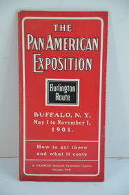
Chicago Burlington and Quincy RR Pan-American Exposition Flyer-1901JM Hobby Supply and Railroad Artifact Auctions4.4(127)See Sold PriceFeb 24, 2024
Chicago Milwaukee and St Paul RY Panama Pacific Exposition Brochure-1915JM Hobby Supply and Railroad Artifact Auctions4.4(127)See Sold PriceFeb 24, 2024
Pennsylvania Central/Pittsburgh Ft Wayne and Chicago 1870 Public TimetableJM Hobby Supply and Railroad Artifact Auctions4.4(127)See Sold PriceFeb 24, 2024
Pair of Early Railroad Maps - 1862 Pittsburgh, Ft. Wayne & Chicago Railway and 1873 PennsylvaniaRail & Road Auctions4.6(165)See Sold PriceMar 07, 2024
Group of Ten Railroad Photographs, Maps, and Prints - New Jersey, Long Island, and New YorkRail & Road Auctions4.6(165)See Sold PriceMar 07, 2024
Early 1990s Chicago Transit Authority Fiberglass Line MapRail & Road Auctions4.6(165)See Sold PriceMar 08, 2024
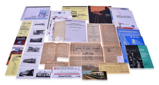
Chicago Transit Authority / Chicago Transportation Paper and Photo Group - CTA, PACE, Metra, SouthRail & Road Auctions4.6(165)See Sold PriceMar 08, 2024
[1893 CHICAGO WORLD’S FAIR, WORLD’S COLUMBIAN EXPOSITION]. ...Potter & Potter Auctions4.6(545)See Sold PriceMar 07, 2024
[CHICAGO]. Group of 21 Medals or Pins for Sporting or Music...Potter & Potter Auctions4.6(545)See Sold PriceMar 07, 2024
[CHICAGO]. Group of Dozens of Advertising Items, including:...Potter & Potter Auctions4.6(545)See Sold PriceMar 07, 2024
[CHICAGO]. Group of Dozens of Advertising Items, including:...Potter & Potter Auctions4.6(545)See Sold PriceMar 07, 2024
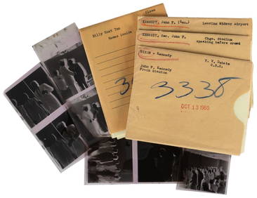
[KENNEDY, John F. (1917-1963) and NIXON, Richard M (1913-19...Potter & Potter Auctions4.6(545)See Sold PriceMar 07, 2024
[PRE-FIRE CHICAGO IMPRINTS]. Group of Two Pre-Fire Broadsid...Potter & Potter Auctions4.6(545)See Sold PriceMar 07, 2024
[CHICAGO]. Group of Nine Books Related to the Chicago Tribu...Potter & Potter Auctions4.6(545)See Sold PriceMar 07, 2024
[CHICAGO]. Rare Pre-Fire Illinois Map: “Blanchard’s Map of ...Potter & Potter Auctions4.6(545)See Sold PriceMar 07, 2024
[BASEBALL]. Group of Three 1907 Championship Chicago White ...Potter & Potter Auctions4.6(545)See Sold PriceMar 07, 2024
Oyster Bay Long Island NY Vintage Color Reproduction Map 12 x 18Mynt Auctions4.6(697)See Sold PriceFeb 23, 2024
3 Vintage The World Lithographs, By JanssonThe Benefit Shop Foundation Inc.4.3(2.9k)See Sold PriceMar 13, 2024


![[MAPS OF CHICAGO AND ILLINOIS]. A group of 4 maps and (1 of 3)](https://p1.liveauctioneers.com/197/128324/65283842_1_x.jpg?height=282&quality=70&version=1537814359)


![[1893 CHICAGO WORLD’S FAIR, WORLD’S COLUMBIAN EXPOSITION]. ... (1 of 2)](https://p1.liveauctioneers.com/928/318880/171360928_1_x.jpg?height=282&quality=70&version=1707501302)
![[CHICAGO]. Group of 21 Medals or Pins for Sporting or Music... (1 of 1)](https://p1.liveauctioneers.com/928/318880/171360929_1_x.jpg?height=282&quality=70&version=1707501302)
![[CHICAGO]. Group of Dozens of Advertising Items, including:... (1 of 1)](https://p1.liveauctioneers.com/928/318880/171360930_1_x.jpg?height=282&quality=70&version=1707501302)
![[CHICAGO]. Group of Dozens of Advertising Items, including:... (1 of 1)](https://p1.liveauctioneers.com/928/318880/171360931_1_x.jpg?height=282&quality=70&version=1707501302)
![[PRE-FIRE CHICAGO IMPRINTS]. Group of Two Pre-Fire Broadsid... (1 of 4)](https://p1.liveauctioneers.com/928/318880/171361167_1_x.jpg?height=282&quality=70&version=1707501302)
![[CHICAGO]. Group of Nine Books Related to the Chicago Tribu... (1 of 1)](https://p1.liveauctioneers.com/928/318880/171361259_1_x.jpg?height=282&quality=70&version=1707501302)
![[CHICAGO]. Rare Pre-Fire Illinois Map: “Blanchard’s Map of ... (1 of 2)](https://p1.liveauctioneers.com/928/318880/171361260_1_x.jpg?height=282&quality=70&version=1707501302)
![[BASEBALL]. Group of Three 1907 Championship Chicago White ... (1 of 2)](https://p1.liveauctioneers.com/928/318880/171361360_1_x.jpg?height=282&quality=70&version=1707501302)


