ATLAS of ANTIENT GEOGRAPHY by SAMUEL BUTLER 1843John McInnis Auctioneers,LLC4.5(505)See Sold PriceFeb 24, 2024
18TH C. ANTIQUE MAP: FRENCH & INDIAN WAR, FRAMEDThomaston Place Auction Galleries4.4(394)See Sold PriceFeb 24, 2024
Rand McNally Railroad Map Cabinet w/ 21 Railroad MapsRail & Road Auctions4.6(165)See Sold PriceMar 08, 2024
Keith Haring - Ink on New York Map, Best Buddies, Inscribed, Signed, and DatedSapphire Auction Gallery4.1(67)See Sold PriceMar 02, 2024
LATE 17TH C. FRENCH MAP OF THE NEW WORLD BY ALEXIS-HUBERT JAILLOT (1632-1712)Thomaston Place Auction Galleries4.4(394)See Sold PriceFeb 24, 2024
Central Railroad of New Jersey Map of Sandy Hook Route-ca. 1903JM Hobby Supply and Railroad Artifact Auctions4.4(127)See Sold PriceFeb 24, 2024
Lot of Six Mixed Atlas Box Cars-HO Scale-New in BoxJM Hobby Supply and Railroad Artifact Auctions4.4(127)See Sold PriceFeb 25, 2024
Rand McNally/Santa Fe Railroad Map of Iowa-1912JM Hobby Supply and Railroad Artifact Auctions4.4(127)See Sold PriceFeb 24, 2024
NICOLAES VISSCHER (NETHERLANDS, 1618-1709) MAP OF THE NEW WORLDThomaston Place Auction Galleries4.4(394)See Sold PriceFeb 24, 2024
17TH C. WORLD MAP BY NICOLAES VISSCHER (NETHERLANDS, 1618-1709)Thomaston Place Auction Galleries4.4(394)See Sold PriceFeb 24, 2024
Lot of Six Mixed Atlas Cabooses-HO Scale-New in BoxJM Hobby Supply and Railroad Artifact Auctions4.4(127)See Sold PriceFeb 25, 2024
SoldGEORG BRAUN & FRANS HOGENBERG FRAMED 16TH C. MAPGEORG BRAUN & FRANS HOGENBERG FRAMED 16TH C. MAP Map engraving by Georg Braun and Frans Hogenberg, of the French cities of Nimes and Bordeaux. Set in a wooden frame under glass. Circa 16th century.&nbSee Sold Price
BRAUN & HOGENBERG 16TH C. MAP OF NIMES & BORDEAUXGEORG BRAUN & FRANS HOGENBERG FRAMED 16TH C. MAP OF NIMES & BORDEAUX Map engraving by Georg Braun and Frans Hogenberg, of the French cities of Nimes and Bordeaux. Set in a wooden frame under glass. CiSee Sold Price
SoldBraun, Georg & Franz Hogenberg Edenburgum, ScotiaeBraun, Georg & Franz Hogenberg Edenburgum, Scotiae Metropolis Cologne, C.16th, hand coloured map, 34 x 46cm, framed and glazedSee Sold Price
SoldMap, Georg Braun and Frans HogenbergGeorg Braun and Frans Hogenberg (German, 16th century), "Gottopia," circa 1588-97, copper engraved map with hand coloring, Latin text on verso, sheet (unframed): 14.5"h x 20.75"wSee Sold Price
16th C. Map "Cite De Saintes" by Braun & HogenbergStriking; Colorful Map Entitled "Cite De Saintes" from the important Civitates Orbis Terrarum (volume 7) by the renowned and respected Georg Braun and Franz Hogenberg | Map is a bird's-eye view of SaiSee Sold Price
SoldMap, Francenbergum, Georg Braun and Frans HogenbergGeorg Braun and Frans Hogenberg (Flemish, 16th century), "Francenbergum, vel ut alij Francoburgum Hassiae Opp," 1581-88, copper engraved map with hand coloring (possibly a later printing), overall (wiSee Sold Price
SoldGeorg Braun and Frans Hogenberg. Calechut c. 1572Georg Braun and Frans Hogenberg. Calechut Celeberrimum Indiae Emporium, hand coloured engraving, first published in 1572, with Ormus [Hormuz], Canonor and S. Georgii [El Mina, West Africa] in three paSee Sold Price
SoldNamurcumNamurcum. Georg Braun (1541-1622) & Frans Hogenberg (fl. c. 1540-1590). Cologne, 1575. Handcolored Engraving. 15 x 20 inches sheetSee Sold Price
Braun and Hogenberg View of NamurcumNamurcum. Georg Braun (1541-1622) & Frans Hogenberg (fl. c. 1540-1590). Hand-colored Engraving. Cologne, 1575. 15 x 20 inches. TRANSLATION OF CARTOUCHE TEXT: Namur, famous city on the Meuse, drawn truSee Sold Price
SoldAnea Quibusdam Anaffa - Azaamuram - Diu - GoaGeorg Braun (1541-1622) & Frans Hogenberg (fl.c.1540-1590). Cologne: c. 1572 or later. Engraved map with early hand color in full. 15 x 21 inches sheet. Magnificent views of Anea, Azemmour, Diu and OlSee Sold Price
Sold16th C HandColored Atlas Map Velitrae Vvlgo BlitriHoefnagel, Georgius (1542-1600) "VELITRAE VVLGO BLITRI", colored engraved atlas map from "Civitates Orbis Terrarum" by Georg Braun and Franz Hogenberg, third part, Latin ed., (printed 1581-1621), publSee Sold Price
Sold16th C Hand Colored Atlas Map Mola - Castel NovoHoefnagel, Georgius (1542-1600), "Mola - Castel Novo", colored engraved atlas map from Georg Braun and Franz Hogenberg's "Civitates Orbis Terrarum" third part, Latin ed., (printed 1581-1621 and publisSee Sold Price
SoldGEORG BRAUN & FRANS HOGENBERG HAND COLORED MAPGEORG BRAUN & FRANS HOGENBERG HAND COLORED DOUBLE-PAGE ENGRAVED MAP, H 13 1/4", W 19", "LUTETIA, VULGARI NOMINE PARIS":DEPICTING 16TH CENTURY PARIS, WITH A DECORATIVE TITLE-CARTOUCHE FEATURING COAT OFSee Sold Price
SoldBraun and Hogenberg View of CairoCairus Olim Babylon...Georg Braun (1541-1622) & Frans Hogenberg (15350-1590). from Civitatus Orbis Terrarum. Hand-colored engraving. Cologne, c. 1572. 16 1/4 x 22 inches sheet.See Sold Price
Braun and Hogenberg View of towns in SpainConil and Xeres de la frontera. Georg Braun (1541-1622) & Frans Hogenberg (15350-1590). from Civitatus Orbis Terrarum. Hand-colored engraving. Cologne, c. 1572-1577. 16 1/4 x 22 inches sheet.See Sold Price
Braun and Hogenberg View of towns in SpainBurgos and Sanct Sebastium. Georg Braun (1541-1622) & Frans Hogenberg (15350-1590). from Civitatus Orbis Terrarum. Hand-colored engraving. Cologne, c. 1572-77. 16 1/4 x 22 inches sheet.See Sold Price
Braun and Hogenberg View of SevilleSeville, Cadiz & Malaga...Georg Braun (1541-1622) & Frans Hogenberg (15350-1590). from Civitatus Orbis Terrarum. Hand-colored engraving. Cologne, c. 1572. 16 1/4 x 22 inches sheet.See Sold Price
Braun and Hogenberg View of AugsburgAugusta Iuxta Figuram...Georg Braun (1541-1622) & Frans Hogenberg (1535-1590). from Civitatus Orbis Terrarum. Hand-colored engraving. Cologne, c. 1572. 16 1/4 x 22 inches sheet.See Sold Price
Braun and Hogenberg View ZwolleSwol. Georg Braun (1541-1622) & Frans Hogenberg (15350-1590). from Civitatus Orbis Terrarum. Hand-colored engraving. Cologne, c. 1572. 16 1/4 x 22 inches sheet.See Sold Price
Braun and Hogenberg View of MarseilleMarseille...Georg Braun (1541-1622) & Frans Hogenberg (15350-1590). from Civitatus Orbis Terrarum. Hand-colored engraving. Cologne, c. 1572. 16 1/4 x 22 inches sheet.See Sold Price
Braun and Hogenberg View of LorraineLoreyne. Georg Braun (1541-1622) & Frans Hogenberg (15350-1590). from Civitatus Orbis Terrarum. Hand-colored engraving. Cologne, c. 1572. 16 1/4 x 22 inches sheet.See Sold Price
SoldCIVITATES ORBIS TERRARUM ATLAS MAP OF VLISSINGENFramed hand-colored engraving on paper, map of the fortified town of Flissinga (Vlissingen), plate from "Civitates orbis terrarum," Georg Braun (German, 1541-1622) and Frans Hogenberg (Flemish, 1535-1See Sold Price
Braun & Hogenberg View of Regensburg, GermanyBRAUN, Georg (1541-1622) & HOGENBERG, Frans (1535-1590). Ratisbona [Regensburg, Germany] Engraved map with original hand color. Cologne, c. 1588. 16 1/4" x 21" sheet. Dedicated to Emperor Rudolph II.See Sold Price
SoldFrans Hogenberg, Pair of 16th c. War EngravingsFrans Hogenberg, Dutch, "Moord te Haarlem door de Spanjaarden", Murders in Harlem by the Spaniards, and a Map showing the Siege of Harlem, each 1573, each framed to display the text on verso. (BPIE100See Sold Price
17TH C. WORLD MAP BY NICOLAES VISSCHER (NETHERLANDS, 1618-1709)Thomaston Place Auction Galleries4.4(394)See Sold PriceFeb 24, 2024
LATE 17TH C. FRENCH MAP OF THE NEW WORLD BY ALEXIS-HUBERT JAILLOT (1632-1712)Thomaston Place Auction Galleries4.4(394)See Sold PriceFeb 24, 2024
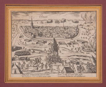
17TH C. ANTIQUE MAP SIEGE OF LA ROCHELLE, FRANCE, FRAMEDThomaston Place Auction Galleries4.4(394)See Sold PriceFeb 24, 2024
1585 OXONIUM VINDESORIUM (OXFORD AND WINDSOR CASTLE) BY BRAUN AND HOGENBERG, FRAMEDThomaston Place Auction Galleries4.4(394)See Sold PriceFeb 24, 2024
EARLY 18TH C. MAP OF ITALY, FRAMEDThomaston Place Auction Galleries4.4(394)See Sold PriceFeb 24, 2024
LATE 16TH C. MAP OF SCOTLAND BY MERCATOR, FRAMEDThomaston Place Auction Galleries4.4(394)See Sold PriceFeb 24, 2024
17TH C. MAP OF THE BERKSHIRES BY JOHN SPEED, FRAMEDThomaston Place Auction Galleries4.4(394)See Sold PriceFeb 24, 2024
18TH C. ANTIQUE MAP: FRENCH & INDIAN WAR, FRAMEDThomaston Place Auction Galleries4.4(394)See Sold PriceFeb 24, 2024
16TH C. BIRDSEYE VIEW OF SEIGE OF STEENWYCK, NETHERLANDS BY FRANS HOGENBERG (1535-1590)Thomaston Place Auction Galleries4.4(394)See Sold PriceFeb 24, 2024
17TH C. ENGLISH LINEAR MAP BY OGILBY, FRAMEDThomaston Place Auction Galleries4.4(394)See Sold PriceFeb 24, 2024
MAP OF SALZBURG BY GEORGE BRAUN & FRANS HOGENBURG. 1588Thomaston Place Auction Galleries4.4(394)See Sold PriceFeb 24, 2024
Antique German Kampen Town Color Copper EtchingHill Auction Gallery 4.7(1k)See Sold PriceFeb 28, 2024
Willem Blaeu, Etc. 17th C. Antiquarian Maps, 2Auctions at Showplace4.6(744)See Sold PriceMar 17, 2024
Two (2) Antique 18th C. Copper Engraved Framed Maps - America & EuropeMagnusson Art Group4.5(53)See Sold PriceMar 14, 2024
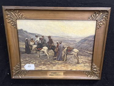
Framed, sgnd O/C, M.S. Nielsen 19 x 25State Line Auctions & Estate Services4.6(281)See Sold PriceFeb 25, 2024
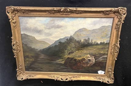
Framed O/C Landscape, A.M. Goodwin 1884 30 x 42State Line Auctions & Estate Services4.6(281)See Sold PriceFeb 25, 2024
"Map of the Parishes of Iberville Most of West Baton Rouge and Including Parts of the Parishes ofCrescent City Auction Gallery4.3(233)See Sold PriceMar 09, 2024
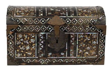
16TH C. JAPANESE MOMOYAMA INLAID LACQUERED CASKET.William Smith Auctions4.6(147)See Sold PriceMar 06, 2024