ATLAS of ANTIENT GEOGRAPHY by SAMUEL BUTLER 1843John McInnis Auctioneers,LLC4.6(502)See Sold PriceFeb 24, 2024
18TH C. ANTIQUE MAP: FRENCH & INDIAN WAR, FRAMEDThomaston Place Auction Galleries4.4(386)See Sold PriceFeb 24, 2024
Rand McNally Railroad Map Cabinet w/ 21 Railroad MapsRail & Road Auctions4.6(165)See Sold PriceMar 08, 2024
Keith Haring - Ink on New York Map, Best Buddies, Inscribed, Signed, and DatedSapphire Auction Gallery4(67)See Sold PriceMar 02, 2024
LATE 17TH C. FRENCH MAP OF THE NEW WORLD BY ALEXIS-HUBERT JAILLOT (1632-1712)Thomaston Place Auction Galleries4.4(386)See Sold PriceFeb 24, 2024
Central Railroad of New Jersey Map of Sandy Hook Route-ca. 1903JM Hobby Supply and Railroad Artifact Auctions4.4(126)See Sold PriceFeb 24, 2024
Lot of Six Mixed Atlas Box Cars-HO Scale-New in BoxJM Hobby Supply and Railroad Artifact Auctions4.4(126)See Sold PriceFeb 25, 2024
Rand McNally/Santa Fe Railroad Map of Iowa-1912JM Hobby Supply and Railroad Artifact Auctions4.4(126)See Sold PriceFeb 24, 2024
NICOLAES VISSCHER (NETHERLANDS, 1618-1709) MAP OF THE NEW WORLDThomaston Place Auction Galleries4.4(386)See Sold PriceFeb 24, 2024
17TH C. WORLD MAP BY NICOLAES VISSCHER (NETHERLANDS, 1618-1709)Thomaston Place Auction Galleries4.4(386)See Sold PriceFeb 24, 2024
Lot of Six Mixed Atlas Cabooses-HO Scale-New in BoxJM Hobby Supply and Railroad Artifact Auctions4.4(126)See Sold PriceFeb 25, 2024
Geograph. Instituts: United Provinces of South AmericaCartographer: Verlage des Geographrischen Instituts Place/Date: Weimar / 1823 Size: 20 1/8 x 17 1/4" Condition: outline color; overall age toning. The United Provinces of South America map from the scSee Sold Price
Geograph. Instituts: United Provinces of South AmericaMap Title: Die vereingten Provinzen von Sud-America Cartographer: Verlage des Geographrischen Instituts Place/Date: Weimar / 1823 Size: 20 1/8 x 17 1/4" Condition: outline color; overall age toning ThSee Sold Price
Geograph. Instituts: United Provinces of South AmericaDescription: The United Provinces of South America map from the scarce German edition of the Carey & Lea Geographical, Statistical, and Historical Atlas. The short-lived United Provinces included nortSee Sold Price
Geograph. Instituts: United Provinces of South AmericaThe United Provinces of South America map from the scarce German edition of the Carey & Lea Geographical, Statistical, and Historical Atlas. The short-lived United Provinces included northern Chili, nSee Sold Price
Geograph. Instituts: United Provinces of South AmericaCartographer: Verlage des Geographrischen Instituts Place/Date: Weimar / 1823 Size: 20 1/8 x 17 1/4" Condition: outline color; overall age toning The United Provinces of South America map from the scaSee Sold Price
Geograph. Instituts: United Provinces of South AmericaMap Title: Die vereingten Provinzen von Sud-America Cartographer: Verlage des Geographrischen Instituts Place / Date: Weimar / 1823 Size: 20 1/8 x 17 1/4" Condition: outline color; overall age toningSee Sold Price
Geo. Instituts: United Provinces of South AmericaCartographer: Verlage des Geographrischen Instituts Place / Date: Weimar / 1823 Size: 20 1/8 x 17 1/4"Condition: outline color; overall age toning The United Provinces of South America map from the scSee Sold Price
1823 map of the United Provinces of South AmericaTitle/Content of Map: 1823 map of the United Provinces of South America Date Printed: 1823, Weimar Cartographer: Verlage des Geographrischen Instituts Size: 20 1/8 x 17 1/4" The United Provinces of SoSee Sold Price
United Provinces of South America, 1823Title/Content of Map: United Provinces of South America, 1823 Date Printed: 1823, Weimar Cartographer: Verlage des Geographrischen Instituts Size: 20 1/8 x 17 1/4" The United Provinces of South AmericSee Sold Price
United Provinces of South America, 1823Title/Content of Map: United Provinces of South America, 1823 Date Printed: 1823, Weimar Cartographer: Verlage des Geographrischen Instituts Size: 20 1/8 x 17 1/4" The United Provinces of South AmericSee Sold Price
Thomson: Map of South America, 1817TITLE/CONTENT OF MAP: 'South America' The map shows South America in the throes of the wars of independence from Spain. The green area marked is the United Provinces of South America (parts of modern-See Sold Price
Set of four colored engraved maps, geographical,Set of four colored engraved maps, geographical, statistical and historical map of the Windward Islands, Leeward Islands, United provinces of South America and map of Hispaniola or St. Domingo. sightSee Sold Price
Geographical, Statistical, and Historical Map of theTitle: Geographical, Statistical, and Historical Map of the United Provinces of South America. Publication Date: 1822 Cartographer: FINLAYSON, J. Publisher: CAREY & LEA Size: 13.1X9 No.49. First attemSee Sold Price
Sold1819 narrative of the Latin American revolutionsHeading: (Latin America - 1819 Revolutions with map) Author: Don Vicente Pazos Title: Letters on the United Provinces of South America, addressed to the Hon. Henry Clay, Speaker of the House of RepresSee Sold Price
Geographical, Statistical, and Historical Map of theTitle: Geographical, Statistical, and Historical Map of the United Provinces of South America. Publication Date: 1822 Cartographer: FINLAYSON, J. Publisher: CAREY & LEA Size: 13.1Height - 9Width No.49See Sold Price
Geographical, Statistical and Historical Map of theTitle: Geographical, Statistical and Historical Map of the United Provinces of South America. Prublication Date: 1828 Cartographer: FINLAYSON, J. Publisher: CAREY & LEA Size: 13Height - 9Width AdditioSee Sold Price
Geographical, Statistical and Historical Map of theMap: Geographical, Statistical and Historical Map of the United Provinces of South America. Publication Date: 1828 Cartographer: FINLAYSON, J. Publisher: CAREY & LEA Size (inches): 13X9 From the thirdSee Sold Price
Bolivia or Upper Peru. Chili. United Provinces of LaTITLE/CONTENT OF MAP: 'Bolivia, or Upper Peru; Chili and the United Provinces of South America, or La Plata' The top image on the right hand side shows the entire map. To view a close up of the map shSee Sold Price
SoldHuntington, South America, 1833An original map of South America published in 1833. It is of special interest in that it shows Patagonia as a separate country and labels what is now Argentina and Uruguay as 'United Provinces.' Size:See Sold Price
United Provinces Chili & Patagonia.Title/Content of Map: United Provinces Chili & Patagonia. Date Printed: 1835 Cartographer: Bradford, T.G. Size: 7.75X10 Shows all of southern South America. 76. Engraved by G.W. Boynton? Margins foxedSee Sold Price
SoldScarce German map of United States in 1805Heading: Author: Güssefeld, Franz Ludwig Title: Charte von Den Vereinigten Staaten von Nord-America nebst Louisiana... Place Published: Weimar Publisher:Verlage des Geograph Instituts Date PubliSee Sold Price
Sold(JAMES MONROE) IMPRINT ON INDEPENDENCE OF SOUTHScarce imprint 'Message from the President of the United States Transmitting...Information [On]...Political Condition of the Provinces of Spanish America' (Washington: E. DeKraaft). 1818. 36pp. 8vo. wSee Sold Price
SoldAtlas School Supply Co. Map Cabinet and Maps 1907Outstanding oak panel cabinet with eight maps, Africa, Canada, Asia, World, United States, South America, North America and Europe Each map is 3 dimensional, in original molded oak frames, 1907 Size oSee Sold Price
United States and South America Stamp collection datingUnited States and South America Stamp collection dating pre 1960, 41 sheets from countries such as USA, Brazil, Argentina and Uruguay. Good Condition. All signed pieces come with a Certificate of AuthSee Sold Price
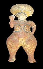
Large Human Effigy Pottery Vessel, Nicely Painted, Pre Columbian Pottery Vessle, South America. 14"Heartland Artifact Auctions Inc4.7(780)See Sold PriceFeb 25, 2024
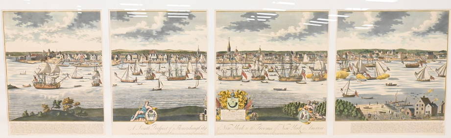
A South Prospect of Ye Flourishing City of New York in the Province of New York, North AmericaNadeau's Auction Gallery4.7(401)See Sold PriceFeb 24, 2024
Two Mother-of-Pearl Relicario Medallions of Jesus.Turner Auctions + Appraisals4.3(311)See Sold PriceFeb 24, 2024
4 3/16" Ancient Inca Stone Mace. South America. Motley COATony Putty Artifacts4.7(404)See Sold PriceMar 09, 2024
Carey, pub. 1796 - A Chart of the West IndiesTrillium Antique Prints & Rare Books4.5(30)See Sold PriceFeb 24, 2024
Carey, pub. 1796 - Map of the State of MarylandTrillium Antique Prints & Rare Books4.5(30)See Sold PriceFeb 24, 2024
Carey, pub. 1796 - Map of GeorgiaTrillium Antique Prints & Rare Books4.5(30)See Sold PriceFeb 24, 2024
Carey, pub. 1796 - Map of The State of South CarolinaTrillium Antique Prints & Rare Books4.5(30)See Sold PriceFeb 24, 2024
Carey, pub. 1796 - Map of KentuckyTrillium Antique Prints & Rare Books4.5(30)See Sold PriceFeb 24, 2024
Carey, pub. 1796 - Map of the Tennassee State formerly part of North Carolina (Tennessee)Trillium Antique Prints & Rare Books4.5(30)See Sold PriceFeb 24, 2024
1822 MAP of NORTH & SOUTH AMERICA GEOGRAPHICAL STATISTICAL HISTORICAL antiqueJasper524.5(9.8k)See Sold PriceFeb 27, 2024
5" Olmec God Effigy Pre-Colombian Pendant, South AmericaHeartland Artifact Auctions Inc4.7(780)See Sold PriceMar 10, 2024
Cooke, George 1801 Antique Map. United States of AmericaAlbion Auctions4.6(336)See Sold PriceMar 01, 2024
Large Fossilized Tortoise Shell - Stylemys NebraskensisArtemis Fine Arts4.8(1.4k)See Sold PriceMar 01, 2024