Frederic de Wit. 17th C. Map of Holland AmsterdamFrederic de Wit. 1680. "Map of Holland" published in Amsterdam. Oriented South to the top, with two very decorative cartouches. 18 ¼" x 22" (image size). Fold running up the center. Good Condition. SSee Sold Price
Soldc. 1680 Hand-Colored Map of the WorldMapsBeautiful c. 1680 Hand-Colored Map of the World! c. 1680, Map of the World: “NOVA ORBIS TABVLA IN LVCEM EDITA,” by Frederic De Wit, Amsterdam, Choice Extremely Fine. Both hemispheres aSee Sold Price
SoldDe Wit Map of England hand-colored by master coloristOrientalior Districtus Regni Angliae... Frederic De Wit (1629/1630 – 1706). Engraved map with original hand color in full. Amsterdam, c. 1680. 24 3/4 x 21 inches sheet. Van Santen applied transparenSee Sold Price
de Wit: Antique Dutch Map of Italy, 1680Title: Novissima et Accuratissima totius Italiae Corsicae et Sardiniae Descriptio. Lovely 17th century Dutch map of Italy Map maker: Frederick de Wit Place and Year: Amsterdam, c. 1680 Dimensions: 56.See Sold Price
Map 'Portugalliae at Algarbiae', 17th centuryMap of Portugal and Algarve 'Novissima Regnorum Portugalliae et Algarbiae descriptio entendata a F. de Wit', published by DE WIT F., Amsterdam, c.1680. Framed. Dim.:58,5x48,5cm.See Sold Price
SoldWillem and Joan Blaeu Map, "Diocese De Rheims, Et LeWillem and Joan Blaeu Map, "Diocese De Rheims, Et Le Paris De Rethel",Amsterdam, c. 1650, a detailed hand-colored map of Rheims and surrounding hamlets by Holland's master cartographers of the 17th c.See Sold Price
SoldPlatte Grondt der Stadt London met Nieuw Model en hoeFrederik De Wit (1630-1706). Engraved Map. Amsterdam: De Wit, c. 1666. 22 3/4 x 21 1/2 inches visible, 32 x 30 3/4 inches framed. Broadsheet map of London, published in the same year as the Great FireSee Sold Price
Sold17TH C. MAP OF MALTA (FREDICO DE WIT, CARTOGRAPHE17TH C. MAP OF MALTA (FREDICO DE WIT, CARTOGRAPHER, 1630-1706 COLOURED ENGRAVING, 17 ¾ X 21 ½" (SIGHT NOT EXAMINED OUT OF FRAME)See Sold Price
Sold17th c Map of China- F. De WitChina.- De Wit (Frederick) Magn‘ Tartari‘, Magni Mogolis Imperii Japon‘ et Chin‘, nova descriptio, China and Tartary with Japan, ornamental cartouche, engraved map with hand-coSee Sold Price
SoldEARLY MAP "INSULA CANDIA EJUSQUE FORTIFICATIO",FREDRICK DE WIT, 18" X 21 1/2", POSSIBLY 17TH C. THIS MAP OF THE ISLAND OF CRETE SHOWING THE ISLAND FOLLOWING THE SIEGE OF CANDIA, 24 YEAR CONFLICT IN WHICH THE OTTOMANS BESIEGED THIS VENETIAN RULED CSee Sold Price
SoldDe Wit Portolan Sea Chart of EuropeTotius Europae Victoria... Frederic De Wit (1630-1706). Engraved map with original hand color. Amsterdam, 1675. 20 x 35 1/2 inches sheet, 27 1/2 x 43 inches framed. “The most striking and decorativeSee Sold Price
Sold1710 Map, de Witt, Nova Persia, Armenia & ArabiaFrederick de Wit (c. 1630-1706). Engraved Map with hand color in full. Amsterdam: F. De Wit, [c. 1710]. Overall framed size is 32 1/2" x 29 1/2". The detail in the Arabian peninsula is based on SansonSee Sold Price
SoldNova Persiae Armeniae Natoliae et ArabiaeFrederick de Wit (c. 1630-1706). Engraved Map with hand color in full. Amsterdam: F. De Wit, [c. 1710]. (20 ¾ x 24 ¾ inches sheet. The detail in the Arabian peninsula is based on Sanson’s map of 1See Sold Price
Sold17th century map of Amsterdam Harbor marked Freder17th century map of Amsterdam Harbor marked Frederick De Wit Excud, framed and matted, 16 in. X 20 in.See Sold Price
SoldFramed Map Regnum NeapolisThe Kingdom of Naples by Frederik de Wit, Cartographer, Amsterdem, 17th C., color accents with regional coat of arms around title cartouche (upper right) and cherubs above scales (lower right) mattedSee Sold Price
De Witt Map Terra NovaTerra Nova... Frederick De Wit (c. 1630-1706). Engraved map with original hand color in part. Amsterdam: Louis Renard, 1715. 20 1/4 x 23 3/4 inches sheet. Third State Sea Chart of the Atlantic Ocean tSee Sold Price
Historical map of Flanders, ''Comitatus FlandriaeHistorical map of Flanders, ''Comitatus Flandriae Tabula, in Lucem edita ...'', copperplateengraving by Frederic de Wit in Amsterdam circa 1690, detailed map with figurative mileage and coat of arms cSee Sold Price
SoldDE WIT ENGRAVING MAP OF THE HAGUE, 17TH C.Unframed map, engraving on paper, "Haga Comitis Vulgo S Graven-Hage" (The Hague), published by Frederick de Wit (Dutch, 1630-1706), cartouche with title in upper left corner, flanked by putti with theSee Sold Price
De Wit. Tabula Comitatus Artesiae. c.1680.[France] De Wit, Frederick. “Tabula Comitatus Artesiae emendata.” Amsterdam, c.1680. Engraved map. 21 3/4” x 18 1/8”. Hand-colored. Two colored cartouches._x000D_ Condition SpoSee Sold Price
SoldDe Wit. Nova et Accurata...Europae. c.1690.[Europe] de Wit, Frederick. “Nova et Accurata Divisa in Regna et Regiones Praecipuas Europae Descriptio.” Amsterdam, c.1690. Engraved map. 22 3/4” x 19 3/4”. Hand-colored. CartSee Sold Price
Sold17th C Frederick De Wit Handcolored Engraving ChristLarge engraving, hand colored of Frederick De Wit (1629/30-1706), engraver most noted for his maps. This engraving of the Passion of Christ. Signed in type at bottom of engraving and listed place of pSee Sold Price
De Wit Map of Southern SwedenDE WIT, Frederik (1629-1726). Accurata Scaniae Blekingiae et Hallandiae Descriptio. Engraved map with original hand color. Amsterdam, F. De Wit, c. 1688. 21 1/2" x 24 1/2" sheet. Regional map of southSee Sold Price
SoldDe Wit Map of the German Holy Roman EmpireDE WIT, Frederick (c. 1630-1706). [Germany]. S.(acri) R.(omani) I.(mperii) in Germania Descriptio... Engraved map with original hand color. Amsterdam, c. 1690. 21 1/2" x 24 3/8" sheet. Antique map ofSee Sold Price
SoldTWO MAPS.TWO MAPS. "Circulus Bavaricus" by Frederic de Wit, Amsterdam, (19 3/4 x 22 1/2 in.); "Arragonia" by Jean Baptiste Labanno, engraved by William and Johann Blaeu, Amsterdam, (16 x 20 in.) Etchings withSee Sold Price
LARGE LATE 17TH C. DUTCH CHART OF CANADA, GREAT LAKES, NEW FRANCE, LABRADOR, HUDSON BAY, BY PIERREThomaston Place Auction Galleries4.4(394)See Sold PriceFeb 24, 2024
17TH C. WORLD MAP BY NICOLAES VISSCHER (NETHERLANDS, 1618-1709)Thomaston Place Auction Galleries4.4(394)See Sold PriceFeb 24, 2024
LATE 17TH C. FRENCH MAP OF THE NEW WORLD BY ALEXIS-HUBERT JAILLOT (1632-1712)Thomaston Place Auction Galleries4.4(394)See Sold PriceFeb 24, 2024
EARLY 18TH C. DUTCH CHART OF PACIFIC OCEAN BY FREDERIK DE WIT (1629-1706) WITH CALIFORNIA AS ANThomaston Place Auction Galleries4.4(394)See Sold PriceFeb 24, 2024
17TH C. ANTIQUE MAP SIEGE OF LA ROCHELLE, FRANCE, FRAMEDThomaston Place Auction Galleries4.4(394)See Sold PriceFeb 24, 2024
EARLY 18TH C. MAP OF ITALY, FRAMEDThomaston Place Auction Galleries4.4(394)See Sold PriceFeb 24, 2024
LATE 16TH C. MAP OF SCOTLAND BY MERCATOR, FRAMEDThomaston Place Auction Galleries4.4(394)See Sold PriceFeb 24, 2024
17TH C. MAP OF THE BERKSHIRES BY JOHN SPEED, FRAMEDThomaston Place Auction Galleries4.4(394)See Sold PriceFeb 24, 2024
17TH C. ENGLISH LINEAR MAP BY OGILBY, FRAMEDThomaston Place Auction Galleries4.4(394)See Sold PriceFeb 24, 2024
Willem Blaeu, Etc. 17th C. Antiquarian Maps, 2Auctions at Showplace4.6(744)See Sold PriceMar 17, 2024
D'Entrecasteaux - Australia: Coasts of Van Diemen's Land (New Holland). 9Trillium Antique Prints & Rare Books4.5(33)See Sold PriceFeb 24, 2024
D'Entrecasteaux - Australia: Chart of Van Diemen's Land (New Holland). 3Trillium Antique Prints & Rare Books4.5(33)See Sold PriceFeb 24, 2024
D'Entrecasteaux - Map of Australia (New Holland), New Zealand, and southern Asia and surroundingTrillium Antique Prints & Rare Books4.5(33)See Sold PriceFeb 24, 2024
Map: A 17thC engraved and hand coloured map after Frederik de Wit (1630-1706) titled Nova Persiae,Claydon Auctioneers Ltd4.3(125)See Sold PriceFeb 26, 2024
17th C. 14K Yellow Gold, Pearl and Enamel Hoop EarringsGWS Auctions Inc.4.4(268)See Sold PriceMar 02, 2024
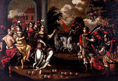
17th C Dutch Old Master Ink & Wash Painting Biblical Figures Rembrandt Pupil 1650'sJasper524.5(9.9k)See Sold PriceFeb 28, 2024
1675: ANTIQUE ILLUSTRATED JULIUS CAESAR MAPS OF ROMAN HISTORYNY Elizabeth 4.1(88)See Sold PriceMar 03, 2024
SILIUS ITALICUS'S 1628 SECOND PUNIC WAR HISTORY IS AN OLD VELLUM.NY Elizabeth 4.1(88)See Sold PriceMar 03, 2024