ATLAS of ANTIENT GEOGRAPHY by SAMUEL BUTLER 1843John McInnis Auctioneers,LLC4.5(505)See Sold PriceFeb 24, 2024
18TH C. ANTIQUE MAP: FRENCH & INDIAN WAR, FRAMEDThomaston Place Auction Galleries4.4(393)See Sold PriceFeb 24, 2024
Rand McNally Railroad Map Cabinet w/ 21 Railroad MapsRail & Road Auctions4.6(165)See Sold PriceMar 08, 2024
Keith Haring - Ink on New York Map, Best Buddies, Inscribed, Signed, and DatedSapphire Auction Gallery4(67)See Sold PriceMar 02, 2024
LATE 17TH C. FRENCH MAP OF THE NEW WORLD BY ALEXIS-HUBERT JAILLOT (1632-1712)Thomaston Place Auction Galleries4.4(393)See Sold PriceFeb 24, 2024
Central Railroad of New Jersey Map of Sandy Hook Route-ca. 1903JM Hobby Supply and Railroad Artifact Auctions4.4(127)See Sold PriceFeb 24, 2024
Lot of Six Mixed Atlas Box Cars-HO Scale-New in BoxJM Hobby Supply and Railroad Artifact Auctions4.4(127)See Sold PriceFeb 25, 2024
Rand McNally/Santa Fe Railroad Map of Iowa-1912JM Hobby Supply and Railroad Artifact Auctions4.4(127)See Sold PriceFeb 24, 2024
NICOLAES VISSCHER (NETHERLANDS, 1618-1709) MAP OF THE NEW WORLDThomaston Place Auction Galleries4.4(393)See Sold PriceFeb 24, 2024
17TH C. WORLD MAP BY NICOLAES VISSCHER (NETHERLANDS, 1618-1709)Thomaston Place Auction Galleries4.4(393)See Sold PriceFeb 24, 2024
Lot of Six Mixed Atlas Cabooses-HO Scale-New in BoxJM Hobby Supply and Railroad Artifact Auctions4.4(127)See Sold PriceFeb 25, 2024
SoldFRAMED HOMANN ATLAS MAP ANCIENT GREECE, 18TH C.Framed Homann atlas map on paper, "Imperii Tvrcici Evropaei terra in primis Graecia," mid 18th c., Johann Christoph Harenberg (German, 1696-1774) cartographer, depicting Greece, as well as the easternSee Sold Price
Sold18TH C ATLAS MAP BY JOHANN HOMANN - HUNGARYTitled Hungariae by German Cartographer Johann Homann (1663 - 1724), published by Homannianis Heredibus in 1752 showing Hungary, Bulgaria, Romania & Serbia. Map is framed, shows foxing & has a tear. MSee Sold Price
SoldFramed 18th C. French Map of Ancient Rome**First Time At Auction** Louis Brion de la Tour (French, 1743-1810) & Louis Charles Desnos (French, 1725-1805), "Suite De L'Histoire De Rome", ca. 1760 to 1770. Copperplate engraved with original hanSee Sold Price
SoldPhaenomena Motuum Irregularium, celestial mapPhaenomena Motuum Irregularium, celestial map, 18th c., Doppelmayr/Homann, each sheet: 19"h x 22.5"w (sight), 43.5"h x 26.75"w (framed ensuite) Provenance: Property from a New York Corporate CollectioSee Sold Price
SoldFRAMED RARE 18TH C. MAP OF CORFU BY HOMANNSPlan de la Place de Corfu avec ses Environs Assiegee Par les Infideles, tranchee ouverte le 25me Juillet jusqu'au 22 me d'Aout, Iour de la Fuite des Ottomans". Homann, J. B. Circa 1740. Hand colored cSee Sold Price
Sold18th/19th C. Map18th/19th C. map. "Magna Britannia, complectens, Angliae, Scotiae, et. Hiberniae Regna IO Bapt Homann Norimberg. Image size 19" H x 22 3/8"W., matted and framedSee Sold Price
Sold18th c. Ancient and Modern History of NationsHeading: Author: Fresnoy, Nicolas Lenglet du Title: Méthode Pour Etudier L'Histoire, avec un catalogue des principaux historiens, & des remarques sur la bonté de leurs ouvrages, & sur le choix desSee Sold Price
Sold18thC Geographical/Astronomical Map, Homann18th Century geographical and astronomical hand-colored engraved map with eight observation tables, 19" x 22 1/2" sight size, framed 25 1/2" x 29", signed Johannus Homann, cartographer. Good conditon.See Sold Price
Sold1828 ATLAS MAPS Ancient & Modern Geography Asia Africa1828 ATLAS MAPS Ancient & Modern Geography Asia Africa Turkey Greece Delamarche Felix Delamarche was a well-known and important French cartographer from the 18th-century. His best and most widely usedSee Sold Price
Sold18th c. Map of Northern Germany, Johann Baptist HomannsEarly 18th century map titled "Circulus Saxoniae inferioris" showing northern Germany including the cities of Berlin and Hamburg by Johann Baptist Homann published circa 1740. Framed map measures 19"See Sold Price
Sold18th C. Schreiber Maps incl. California as Island.18th C. Schreiber Maps incl. California as Island. circa 1750, nicely handcolored, matted, and framed; includes the World Atlas, America; Asia; Europe; and Africa. Note: Johann Georg Schreiber, a GermSee Sold Price
18th C. Schreiber Maps incl. California as Island. (5)18th C. Schreiber Maps; circa 1750, nicely handcolored, matted, and framed; includes the World Atlas, America; Asia; Europe; and Africa. Note: Johann Georg Schreiber, a German cartographer and geograSee Sold Price
Tab. X. Europae, Macedoniam, Epirum Ac Peloponnesum...Reserve Reduced! Title: Tab. X. Europae, Macedoniam, Epirum Ac Peloponnesum... Date: c1695 Cartographer: Ptolemy Size (inches): 13.4X17.5 Version of 16th C. Ptolemaic map of Ancient Greece. InterestinSee Sold Price
Sold1733 c. DeLisle Map of Ancient Southern Greece --Title/Content of Map: 1733 c. DeLisle Map of Ancient Southern Greece -- Graeciae Pars Meridionalis Date: 1733 c., London Cartographer: G DeLisle Size: 18.8 x 25.2 in. A highly attractive, large De L'ISee Sold Price
1733 c. DeLisle Map of Ancient Northern Greece --Reserve Reduced! Title/Content of Map:1733 c. DeLisle Map of Ancient Northern Greece -- Graeciae Pars Septentrionalis Date:1733 c., London Cartographer:G DeLisle Size:18.1 x 25.2 in. A highly attractiSee Sold Price
1733 c. DeLisle Map of Ancient Northern Greece --Title/Content of Map: 1733 c. DeLisle Map of Ancient Northern Greece -- Graeciae Pars Septentrionalis Date: 1733 c., London Cartographer: G DeLisle Size: 18.1 x 25.2 in. A highly attractive, large DeSee Sold Price
1733 c. DeLisle Map of Ancient Northern Greece --Title/Content of Map: 1733 c. DeLisle Map of Ancient Northern Greece -- Graeciae Pars Septentrionalis Date: 1733 c., London Cartographer: G DeLisle Size: 18.1 x 25.2 in. A highly attractive, large DeSee Sold Price
1733 c. DeLisle Map of Ancient Southern Greece --Title/Content of Map: 1733 c. DeLisle Map of Ancient Southern Greece -- Graeciae Pars Meridionalis Date: 1733 c., London Cartographer: G DeLisle Size: 18.8 x 25.2 in. A highly attractive, large De L'ISee Sold Price
1733 c. DeLisle Map of Ancient Northern Greece --Title/Content of Map: 1733 c. DeLisle Map of Ancient Northern Greece -- Graeciae Pars Septentrionalis Date: 1733 c., London Cartographer: G DeLisle Size: 18.1 x 25.2 in. A highly attractive, large DeSee Sold Price
1733 c. DeLisle Map of Ancient Southern Greece --Reserve Reduced! Title/Content of Map:1733 c. DeLisle Map of Ancient Southern Greece -- Graeciae Pars Meridionalis Date:1733 c., London Cartographer:G DeLisle Size:18.8 x 25.2 in. A highly attractive,See Sold Price
1733 c. DeLisle Map of Ancient Northern Greece --Title/Content of Map: 1733 c. DeLisle Map of Ancient Northern Greece -- Graeciae Pars Septentrionalis Date: 1733 c., London Cartographer: G DeLisle Size: 18.1 x 25.2 in. A highly attractive, large DeSee Sold Price
1733 c. DeLisle Map of Ancient Northern Greece --Title/Content of Map: 1733 c. DeLisle Map of Ancient Northern Greece -- Graeciae Pars Septentrionalis Date: 1733 c., London Cartographer: G DeLisle Size: 18.1 x 25.2 in. A highly attractive, large DeSee Sold Price
Sold18TH C. HOMANN HAND COLORED MAP OF CASPIAN SEAThe framed map also depicting parts of Russia. 19.5" X 23" Provenance: A New Haven, CT estateSee Sold Price
SoldAn 18th C Georg Lotter Map,"Regna Portugalliae et Algarbiae", signed in the plate Georg Frederich Lotter, 1782, partially hand colored, probably from a large folio atlas. Matted and framed under glass. 23" high, 19 1/2" wide. MSee Sold Price
LATE 18TH C. VERY LARGE CHART OF NORTHEAST CANADA BY DES BARRES (1721-1824), 1780, FRAMEDThomaston Place Auction Galleries4.4(393)See Sold PriceFeb 24, 2024
EARLY 18TH C. DUTCH CHART OF PACIFIC OCEAN BY FREDERIK DE WIT (1629-1706) WITH CALIFORNIA AS ANThomaston Place Auction Galleries4.4(393)See Sold PriceFeb 24, 2024
LARGE EARLY 18TH C. DUTCH CHART OF UPPER NORTH AMERICA, PIERRE MORTIER (1661-1711), FRAMEDThomaston Place Auction Galleries4.4(393)See Sold PriceFeb 24, 2024
EARLY 18TH C. MAP OF ITALY, FRAMEDThomaston Place Auction Galleries4.4(393)See Sold PriceFeb 24, 2024
LATE 16TH C. MAP OF SCOTLAND BY MERCATOR, FRAMEDThomaston Place Auction Galleries4.4(393)See Sold PriceFeb 24, 2024
17TH C. MAP OF THE BERKSHIRES BY JOHN SPEED, FRAMEDThomaston Place Auction Galleries4.4(393)See Sold PriceFeb 24, 2024
18TH C. ANTIQUE MAP: FRENCH & INDIAN WAR, FRAMEDThomaston Place Auction Galleries4.4(393)See Sold PriceFeb 24, 2024
17TH C. ENGLISH LINEAR MAP BY OGILBY, FRAMEDThomaston Place Auction Galleries4.4(393)See Sold PriceFeb 24, 2024
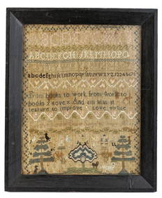
(18th c) SAMPLER by SARAH BROWN born 1780.John McInnis Auctioneers,LLC4.5(505)See Sold PriceFeb 25, 2024
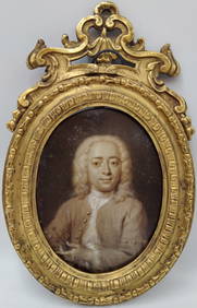
18th c. Cornelis Troost Miniature Portrait of Philips ZweertsHeritage Gallery Auctions4.4(60)See Sold PriceMar 10, 2024
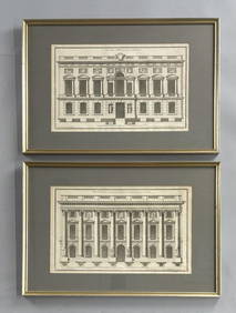
2 Framed 18th C. Parisian Architectural PrintsEpic Auctions and Estate Sales4.6(210)See Sold PriceMar 02, 2024
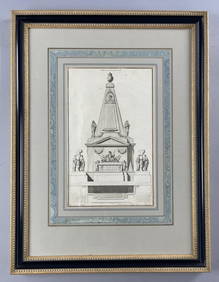
18th C. French Neoclassical Tomb PrintEpic Auctions and Estate Sales4.6(210)See Sold PriceMar 02, 2024
SAMUEL COLLINS (ATTRIB) PORTRAIT MINIATURE, 18TH C.Austin Auction Gallery4.7(1.2k)See Sold PriceFeb 25, 2024
Johann Homann Hand-Colored Map Engraving, c. 1730Auctions at Showplace4.6(740)See Sold PriceMar 17, 2024
Two (2) Antique 18th C. Copper Engraved Framed Maps - America & EuropeMagnusson Art Group4.5(53)See Sold PriceMar 14, 2024
THE WHOLE CHRONICLE OF POLYBIUS ANCIENT IN ENGLISH, 1756NY Elizabeth 4.2(86)See Sold PriceMar 03, 2024
ANTIQUE 18TH C FEMALE PORTRAIT WATERCOLOR PAINTINGAntique Arena Inc.4.5(878)See Sold PriceMar 09, 2024