ATLAS of ANTIENT GEOGRAPHY by SAMUEL BUTLER 1843John McInnis Auctioneers,LLC4.5(505)See Sold PriceFeb 24, 2024
18TH C. ANTIQUE MAP: FRENCH & INDIAN WAR, FRAMEDThomaston Place Auction Galleries4.4(393)See Sold PriceFeb 24, 2024
Rand McNally Railroad Map Cabinet w/ 21 Railroad MapsRail & Road Auctions4.6(165)See Sold PriceMar 08, 2024
Keith Haring - Ink on New York Map, Best Buddies, Inscribed, Signed, and DatedSapphire Auction Gallery4(67)See Sold PriceMar 02, 2024
LATE 17TH C. FRENCH MAP OF THE NEW WORLD BY ALEXIS-HUBERT JAILLOT (1632-1712)Thomaston Place Auction Galleries4.4(393)See Sold PriceFeb 24, 2024
Central Railroad of New Jersey Map of Sandy Hook Route-ca. 1903JM Hobby Supply and Railroad Artifact Auctions4.4(127)See Sold PriceFeb 24, 2024
Lot of Six Mixed Atlas Box Cars-HO Scale-New in BoxJM Hobby Supply and Railroad Artifact Auctions4.4(127)See Sold PriceFeb 25, 2024
Rand McNally/Santa Fe Railroad Map of Iowa-1912JM Hobby Supply and Railroad Artifact Auctions4.4(127)See Sold PriceFeb 24, 2024
NICOLAES VISSCHER (NETHERLANDS, 1618-1709) MAP OF THE NEW WORLDThomaston Place Auction Galleries4.4(393)See Sold PriceFeb 24, 2024
17TH C. WORLD MAP BY NICOLAES VISSCHER (NETHERLANDS, 1618-1709)Thomaston Place Auction Galleries4.4(393)See Sold PriceFeb 24, 2024
Lot of Six Mixed Atlas Cabooses-HO Scale-New in BoxJM Hobby Supply and Railroad Artifact Auctions4.4(127)See Sold PriceFeb 25, 2024
SoldFramed 18th C. French Map of Ancient Rome**First Time At Auction** Louis Brion de la Tour (French, 1743-1810) & Louis Charles Desnos (French, 1725-1805), "Suite De L'Histoire De Rome", ca. 1760 to 1770. Copperplate engraved with original hanSee Sold Price
Sold18th c. French MapFramed 18th c. steel engraved & colored 18 1/4" x 23 3/4" "A New Map of France" by John Senex, 19 1/2" x 25 1/4" overall size framed.See Sold Price
17th/18th c Map of Rome by Christoph Weigelins17th/18th c Map of Rome by Christoph Weigelins, hand tinted print, labeled in latin, matted and framed. Appx 12 1/2" x 17 1/4" viewed, frame 19" x 24". Good condition with some discoloration in the upSee Sold Price
SoldFRAMED HOMANN ATLAS MAP ANCIENT GREECE, 18TH C.Framed Homann atlas map on paper, "Imperii Tvrcici Evropaei terra in primis Graecia," mid 18th c., Johann Christoph Harenberg (German, 1696-1774) cartographer, depicting Greece, as well as the easternSee Sold Price
SoldPAIR FRENCH 18TH C EUROPEAN MONARCHIES MAPSPAIR FRENCH 18TH CENTURY EUROPEAN MONARCHIES MAPS: Circa 1760 French pair of maps depicting ancient monarchies of Europe and Eurasia. Titled ''Partie Occidentale de la Carte des Anciennes Monarchies''See Sold Price
SoldETIENNE DUPERAC, (French, c. 1520-1604), Urbis RomaeETIENNE DUPERAC (French, c. 1520-1604) Urbis Romae Sciographia ex Antiquis Monumentis Accuratiss Delineata Descrizione (Study of the Ruins and Monuments of Ancient Rome) Engraved map with later hand cSee Sold Price
(2)MAPS, TURKEY, ARABIA ETC. & AMERICA, DELAMARCHE(lot of 2) Framed maps by Felix Delamarche (French, 18th c. - 1st half 19th c.), son of Charles Francois Delamarche (French, 1740-1817), comprising: (1) "Turquie D'Asie, Arabie, Perse, Kandahar" 1812,See Sold Price
SoldFramed 18th century French maps, Abraham Ortelius(lot of 2) Framed 18th century French maps, including an Abraham Ortelius (1528-1598), Poictou / Pictonum Vicinarum que Regionum Fidiss Descripto., Antwerp, C. Plantin, 1579, hand colored map of the PSee Sold Price
SoldFRENCH BONNE MAP OF CHINA, KOREA & JAPAN, 18TH C.Framed engraving with hand coloring on paper, map of China, Korea, and Japan, "Empire De La Chine, Rme De Coree et Isles Du Japon," Rigobert Bonne (French, 1727-1794) cartographer, engraved by PietroSee Sold Price
SoldFrench 19th C engraving of figures in Ancient RoFrench 19th C engraving of figures in Ancient Rome, 8 3/4" x 11 1/4", framed 17 1/2" x 21"See Sold Price
SoldAntique French Map of St. AugustineAntique French Map of St. Augustine, "Plan de la Ville et Port de St. Augustin", late 18th/early 19th c., hand-colored engraved map, sight 8 1/2 in. x 12 in., framed. Provenance: Estate of Faith K. TiSee Sold Price
SoldEngraved map, Delahaye, Paris, 18th c.Framed hand-colored engraved map, Carte du Departement de la Seine et de l'Oise, 1791, by Louis Delahaye (French, 18th century), plate: 19.5''h x 19.5''w, overall: 33.5''h x 32''wSee Sold Price
SoldTwo 18th Century French Made European MapsTwo 18th century French made map prints, framed. "Carte Des Isles Britanniques" 23" x 30" map of the British Islands made in Paris by C.F. Delamarche, and 23" x 28 1/2" 1702 French West Coast map. SomSee Sold Price
Sold(2) 18TH CENTURY FRENCH & GERMAN MAPS(lot of 2) Maps; (1) framed map from the "Atlas Universal" by Gilles Robert de Vaugondy and son (France, c.1723-1786), entitled "Gouvernement General de L'Isle de France, divise par Pays, Par le Sr. RSee Sold Price
Framed Engraved Map of Ancient Roman Empire - 1763Cartographer: Louis Brion de la Tour (French, 1743-1810). Title: "Rome Empire Old Map Suite De L'Histoire De Rome la Tour" 1763. A copperplate engraving with hand coloring and a text explaining the hiSee Sold Price
French Manuscript Map of Minorca[French, 18th Century] Anonymous. Plan of Fort St. Philip on the island of Minorca. Manuscript Map, Pen and ink with wash colors. Paris, c. 1756. 16 3/4" x 22" sheet, 26 1/2" x 31 1/2" framed. ManuscrSee Sold Price
Manuscript Map of St. Lawrence River, CanadaANONYMOUS, Manuscript Map. [Echelle de la Lieux Marine de France]. Pen and ink on paper. c. Early-Mid 18th Century. 19 3/4 x 28 inches sheet, 29 x 37 inches framed. AN IMPORTANT FRENCH NAVY MANUSCRIPTSee Sold Price
Sold18th C Map Ancient World JerusalemEngraved plate showing maps of ancient world including inset of Judea and Samaria and one of Jerusalem. Early 18th century.Very Good, trimmed to plate lines, measures 7 x 5.5". Reserve: $20.00 ShippinSee Sold Price
Sold18TH C. FRENCH MAP OF THE AMERICAS"Amerique Septentrionale, dressee, sur les Relations plus modernes de Voyageurs et Navigateurs et divisee suivant les differentes possessions des Europens" par la Sr. Robert de Vagoundy, fils de Mr. RSee Sold Price
Sold18th C. French Map w/ Oiled Paper, ex-Sotheby'sEurope, France, map from 1709 CE, oiled paper overlays from 1756 to 1763 CE, owned by Louis-Alexandre Berthier (1753 to 1815 CE), Marshal, Vice-Constable of France, and Chief of Staff (Major general)See Sold Price
Sold18TH C. FRENCH MAP 'CARTE DES ISLES SANDWICH'From R. Bonne and N. Desmarest's Atlas, circa 1780. Measures approximately 10 x 14inches.See Sold Price
Sold(2) FRAMED 18TH C. FRENCH ENGRAVINGSLot of (2) Early French Hand Colored engravings, from "Costumes de Differents Pays" engraved by Jacques Grasset de Saint Sauveur (France, 1757-1810), L. Labrousse and J. Laroque, circa 1797, in matchiSee Sold Price
Sold18thC. French map of CanadaLate 18th C. engraved French map of Canada, hand tinted on laid paper, shows the Great Lakes, 14-7/8" x 10" h., from a map of the New World, 1778, M. Bonne. CONDITION: Unframed. In an archival mat. VeSee Sold Price
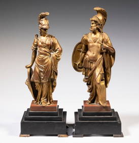
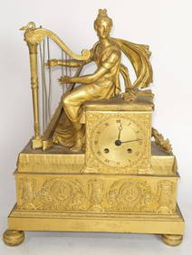
LATE 18TH C FRENCH PAIR OF GILT BRONZE STATUES OF THE GREEK GOD AND GODDESS OF WARThomaston Place Auction Galleries4.4(393)See Sold PriceFeb 24, 2024
EARLY 18TH C. MAP OF ITALY, FRAMEDThomaston Place Auction Galleries4.4(393)See Sold PriceFeb 24, 2024
18TH C. ANTIQUE MAP: FRENCH & INDIAN WAR, FRAMEDThomaston Place Auction Galleries4.4(393)See Sold PriceFeb 24, 2024
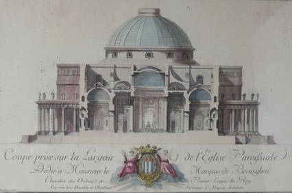
Charles Dupuis French 18th century, Pair Hand Colored Engravings, ArchitecturalGlobal Auctions Company4.3(36)See Sold PriceMar 03, 2024
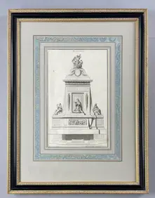
18th C. French Neoclassical Tomb Print IEpic Auctions and Estate Sales4.6(210)See Sold PriceMar 02, 2024
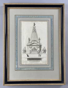
18th C. French Neoclassical Tomb PrintEpic Auctions and Estate Sales4.6(210)See Sold PriceMar 02, 2024
18th/19th C. Engravings Instrumens des SacrificesEpic Auctions and Estate Sales4.6(210)See Sold PriceMar 02, 2024
Two (2) Antique 18th C. Copper Engraved Framed Maps - America & EuropeMagnusson Art Group4.5(53)See Sold PriceMar 14, 2024
1758 MAP PARTIE DE LA MER GLACIALE contenants La Nouvelle Zemble RUSSIA antiqueJasper524.5(9.9k)See Sold PriceFeb 27, 2024
18th C. Francois N Martinet Colored Engraving of BirdsArtemis Fine Arts4.8(1.4k)See Sold PriceFeb 26, 2024
C. M. Rols 1800s Antique Print Insecurities Framed SignedKCM Galleries4.7(164)See Sold PriceFeb 25, 2024
1742 BIBLE IN FRENCH, ANCIENT, LEATHER-BOUND, OLD AND NEW TESTAMENTNY Elizabeth 4.2(86)See Sold PriceMar 03, 2024
THE WHOLE CHRONICLE OF POLYBIUS ANCIENT IN ENGLISH, 1756NY Elizabeth 4.2(86)See Sold PriceMar 03, 2024
1792 OLD INDIA HISTORY ANTIQUE ILLUSTRATED WITH MAPS OF THE EIGHTEENTH CENTURY IN FRENCHNY Elizabeth 4.2(86)See Sold PriceMar 03, 2024
Limited Edition Baccarat Winged Bull (Persian Empire)Antique Kingdom4.1(21)See Sold PriceMar 08, 2024
ANTIQUE 18TH C FEMALE PORTRAIT WATERCOLOR PAINTINGAntique Arena Inc.4.5(878)See Sold PriceMar 09, 2024
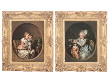
18TH C FRENCH PAINTINGS BY PIERRE ALEXANDRE WILLEAntique Arena Inc.4.5(878)See Sold PriceMar 09, 2024