French Manuscript Map of Minorca[French, 18th Century] Anonymous. Plan of Fort St. Philip on the island of Minorca. Manuscript Map, Pen and ink with wash colors. Paris, c. 1756. 16 3/4" x 22" sheet, 26 1/2" x 31 1/2" framed. ManuscrSee Sold Price
French Manuscript Map of IndiaFrench Manuscript Map of Northeast India Watercolor and ink on paper. Ca.1765-1770. 42 x 66 inches Marks the End of French Colonial Aspirations in India, The Most Accurate Manuscript Map of India fromSee Sold Price
Antibes France Manuscript Plan[Antibes, France]. Plan de la Ville et Fort Quarre d'Antibe. Manuscript map in ink and colors on paper. France, 18th century. 18 1/4" x 34 1/2" sheet. French manuscript map of historic Antibes includiSee Sold Price
Sold19th century French School. Manuscript map of Indi19th century French School. Manuscript map of India and Ceylon,with detailed place names and scales, pen and black ink on vellum, 205 x 225mm., central vertical and horizontal folds, slight fiSee Sold Price
Manuscript Map of French Island Belle IsleUNKNOWN ARTIST. Carte Generale de Belle Isle. Manuscript map in ink with original wash. French, c. late 18th century. 27" x 44 3/4" sheet. Belle-Isle is an island off the coast of Brittany in northwesSee Sold Price
[MAPS, AUSTRALIA, WORLD] French Manuscript Atlas, 1838[Louise Lucas] French Manuscript Atlas, 1838 London: Edward Stanford, 1838.39cm x 27cm. 19 double page manuscript maps. Quarter green leather. 19 hand-drawn and coloured maps on double-size sheets (39See Sold Price
[MAPS, AUSTRALIA, WORLD] French Manuscript Atlas, 1838[Louise Lucas] French Manuscript Atlas, 1838 London: Edward Stanford, 1838.39cm x 27cm. 19 double page manuscript maps. Quarter green leather. 19 hand-drawn and coloured maps on double-size sheets (39See Sold Price
SoldManuscript Maps C1880 Lot of 4 French Rivers etcIncl Rhone, Seine, Loire and Garonne. Ink on Wove Paper by Jeanne Bockairy? Fair standard only. Paper Size: 9 x 5.5 inch (23 x 14cm) Damp smell present. Otherwise fineSee Sold Price
SoldManuscript Plan of Fort St. Philip on the island ofPlan of Fort St. Philip on the island of Minorca. Anonymous. Paris, c. 1756. Manuscript Map, Pen and ink with wash colors. 16 3/4 x 22 inches sheet, 26 1/2 x 31 1/2 inches framed. Manuscript Plan of oSee Sold Price
Atlas Geographique Manuscript Map AtlasDrawn and handpainted by Sophie de Baure. C 1840. French manuscript atlas with title page, table of contents and 20 beautiful hand drawn and colored maps. It is bound in contemporary burgundy full MorSee Sold Price
SoldLa Harpe Manuscript Map of LouisianaLA HARPE, Jean-Baptiste Bénard de (1683-1765). 'CARTE NOUVELLE DE LA PARTIE DE L'OUEST DE LA LOUISIANNE'. Manuscript map with watercolor wash in shades of green and brown with black and red ink; a feSee Sold Price
SoldA FRENCH MAP OF ARABIA, DATED 1882Manuscript map of Arabia, pen and ink on paper, indicates the routes followed by the caravans towards Mecca during the Hajj.The trace of the great Shami/Syrian mahmal according to the report of the doSee Sold Price
Manuscript Map of Gibraltar*** START PRICE IS THE RESERVE *** [Europe] MONTFERRIER, Sarrazin de (1792-1863). Siege de Gibraltar en 1782. Sous les ordres de M. R. Le Duc de Crillon Mahon. Pen and ink and color wash on paper. WatSee Sold Price
Manuscript Map of St. Lawrence River, CanadaANONYMOUS, Manuscript Map. [Echelle de la Lieux Marine de France]. Pen and ink on paper. c. Early-Mid 18th Century. 19 3/4 x 28 inches sheet, 29 x 37 inches framed. AN IMPORTANT FRENCH NAVY MANUSCRIPTSee Sold Price
Manuscript Map of Prague 1742FRENCH SCHOOL (Mid-18th Century).Prague avec les environs, ainsi que la position des armees francais autrichiennes et ses attaques...Manuscript map in pen and ink with original hand color.France, c. 1See Sold Price
SoldManuscript Maps C1880 Lot of 6 of FranceIncl Orne and Region, South of France, Gulf of Lion, Loire et la Garon, Entre la Garonne, and one other of the French Coast. Ink on Wove Paper by Jeanne Bockairy? Fair standard only. Paper Size: 9 x 5See Sold Price
SoldA mixed group of 10 manuscript maps,3 similar decorative French maps of the British Isles, France and Italy, 5 others, similar, of Africa, North America, Brazil, Scandinavia and Switzerland, with one of Europe and another of Italy, penSee Sold Price
Manuscript Plan of of Fort Philippe (Menorca).[French, 18th Century] Anonymous. Plan of Fort St. Philip on the island of Menorca. Manuscript Map, Pen and ink with wash colors. Paris, c. 1756. 16 3/4 x 22 inches sheet, 26 1/2 x 31 1/2 inches frameSee Sold Price
SoldBarthélémy Lafon (French/American, 1769-1820)Barthélémy Lafon (French/American, 1769-1820), "Plan de l'Habitation de Mr. Michel Dragon arpentee par ordre de B. Lafon Ing., le mois de decembre, 1815", watercolor and ink manuscript map, 13 1/2 iSee Sold Price
SoldMinorca. "Plan of Fort St. Philip and its environsMaps.- Minorca. "Plan of Fort St. Philip and its environs, with the French Encampments, Batteries &c," ?from the Gentleman's Magazine, engraved map, folds, tears in margins, chipped, c. 270 xSee Sold Price
SoldFrench Map of the World Decorative ArtsFrench Map of the World, piece appears to be hand drawn and colored, inscriptions to piece in French, label to reverse reads ‘Le Normand, Charles 14 x 19 Manuscript World Map’, subject a map of thSee Sold Price
SoldMap of French Senegal and New Guinea 1727Framed map of French Senegal and New Guinea 1727 illuminated manuscript French framed- Nice condition.See Sold Price
Sold1882 French geography manuscript,[Devoirs de Geographie/Ville de Niort/Ecole Communale de Sud], 50 pages hand written text and 25 hand drawn, colored maps relating to France, hardbound with cloth boards and gilt titles, 10 x 13 in. PSee Sold Price
Gentlemen's Magazine Map of Fort St. Philip, 1756Map: 1756 Map of Minorca's St. Philip and Mahon Harbor -- A Plan of Fort St. Philip and its Environs with the French Encampments, Batteries, etc. Cartographer: Gentlemen's Magazine Year / Place: 1756,See Sold Price
LATE 17TH C. FRENCH MAP OF THE NEW WORLD BY ALEXIS-HUBERT JAILLOT (1632-1712)Thomaston Place Auction Galleries4.4(389)See Sold PriceFeb 24, 2024
18TH C. ANTIQUE MAP: FRENCH & INDIAN WAR, FRAMEDThomaston Place Auction Galleries4.4(389)See Sold PriceFeb 24, 2024
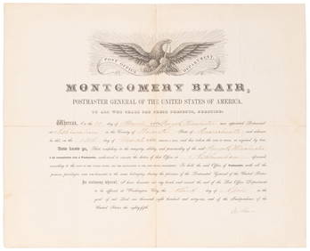
SOMERSET, Lord Charles (1767-1831) and BLAIR, Montgomery (1...Potter & Potter Auctions4.6(544)See Sold PriceMar 07, 2024
1790 AFRICA TRAVELS Voyages dans le pays des Hottentots ILLUSTRATED antique RAREJasper524.5(9.8k)See Sold PriceFeb 27, 2024
COLONIES FRANÇAISES en AFRIQUE. Africa Sénégal Madagascar. LEVASSEUR c1850 mapJasper524.5(9.8k)See Sold PriceFeb 28, 2024
L'Afrique Françoise ou du Senegal'. French West Africa. DE L’ISLE 1727 mapJasper524.5(9.8k)See Sold PriceFeb 28, 2024
1774: AN ANTIQUE ILLUSTRATED TWO-VOLUME HISTORY OF PERUVIAN DISCOVERY AND CONQUEST WITH MAPNY Elizabeth 4.3(85)See Sold PriceMar 03, 2024
1792 OLD INDIA HISTORY ANTIQUE ILLUSTRATED WITH MAPS OF THE EIGHTEENTH CENTURY IN FRENCHNY Elizabeth 4.3(85)See Sold PriceMar 03, 2024
DIDEROT DENIS: (1713-1784)International Autograph Auctions Europe S.L.4.5(52)See Sold PriceMar 14, 2024
SAND GEORGE: (1804-1876)International Autograph Auctions Europe S.L.4.5(52)See Sold PriceMar 14, 2024
BECQUEREL HENRI: (1852-1908)International Autograph Auctions Europe S.L.4.5(52)See Sold PriceMar 14, 2024


![[MAPS, AUSTRALIA, WORLD] French Manuscript Atlas, 1838 (1 of 4)](https://p1.liveauctioneers.com/8597/288240/152537443_1_x.jpg?height=282&quality=70&version=1683682013)
![[MAPS, AUSTRALIA, WORLD] French Manuscript Atlas, 1838 (1 of 4)](https://p1.liveauctioneers.com/8597/296734/157735923_1_x.jpg?height=282&quality=70&version=1690170365)