ATLAS of ANTIENT GEOGRAPHY by SAMUEL BUTLER 1843John McInnis Auctioneers,LLC4.5(505)See Sold PriceFeb 24, 2024
18TH C. ANTIQUE MAP: FRENCH & INDIAN WAR, FRAMEDThomaston Place Auction Galleries4.4(393)See Sold PriceFeb 24, 2024
Rand McNally Railroad Map Cabinet w/ 21 Railroad MapsRail & Road Auctions4.6(165)See Sold PriceMar 08, 2024
Keith Haring - Ink on New York Map, Best Buddies, Inscribed, Signed, and DatedSapphire Auction Gallery4.1(67)See Sold PriceMar 02, 2024
LATE 17TH C. FRENCH MAP OF THE NEW WORLD BY ALEXIS-HUBERT JAILLOT (1632-1712)Thomaston Place Auction Galleries4.4(393)See Sold PriceFeb 24, 2024
Central Railroad of New Jersey Map of Sandy Hook Route-ca. 1903JM Hobby Supply and Railroad Artifact Auctions4.4(127)See Sold PriceFeb 24, 2024
Lot of Six Mixed Atlas Box Cars-HO Scale-New in BoxJM Hobby Supply and Railroad Artifact Auctions4.4(127)See Sold PriceFeb 25, 2024
Rand McNally/Santa Fe Railroad Map of Iowa-1912JM Hobby Supply and Railroad Artifact Auctions4.4(127)See Sold PriceFeb 24, 2024
NICOLAES VISSCHER (NETHERLANDS, 1618-1709) MAP OF THE NEW WORLDThomaston Place Auction Galleries4.4(393)See Sold PriceFeb 24, 2024
17TH C. WORLD MAP BY NICOLAES VISSCHER (NETHERLANDS, 1618-1709)Thomaston Place Auction Galleries4.4(393)See Sold PriceFeb 24, 2024
Lot of Six Mixed Atlas Cabooses-HO Scale-New in BoxJM Hobby Supply and Railroad Artifact Auctions4.4(127)See Sold PriceFeb 25, 2024
SoldEuropean & British Isles Map 18th C.Germany, France, Italy, Spain & British Isles Map . Mons. D'Anville. 1771. Hand-colored. ; 20" x 18 1/2"See Sold Price
SoldTwo 18th Century French Made European MapsTwo 18th century French made map prints, framed. "Carte Des Isles Britanniques" 23" x 30" map of the British Islands made in Paris by C.F. Delamarche, and 23" x 28 1/2" 1702 French West Coast map. SomSee Sold Price
SoldNine 19th C. Maps of EuropeLot of nine early 19th C. maps of European countries, including the British Isles, France, The Netherlands, Spain/Portugal, Russia, etc. Various dates and publishers.See Sold Price
18th C. British Sergeant at Arms Iron HalberdWestern Europe, British Isles, ca. 18th century CE. An iron halberd with a beautiful point that is both deadly and decorative. The head is elaborate, downcurving on one side and with a wide, flat bladSee Sold Price
18th C. Western European / British Iron PartisanWestern Europe, possibly British Isles, ca. 18th century CE. An iron partisan with a beautiful point that is both deadly and decorative. The head is elaborate and symmetrical, with upward and downwardSee Sold Price
Sold18th C. British Iron Halberd w/ Wood Pole**Originally Listed At $650** Western Europe, British Isles, ca. 18th century CE. An iron halberd with a beautiful point that is both deadly and decorative. The head is elaborate, downcurving on one sSee Sold Price
18th C. Western European / British Iron HalberdWestern Europe, possibly British Isles, ca. 18th century CE. An iron halberd with a beautiful point that is both deadly and decorative. The head is elaborate and symmetrical, with upward and downward-See Sold Price
18th C. British Iron Halberd w/ Wood PoleWestern Europe, British Isles, ca. 18th century CE. An iron halberd with a beautiful point that is both deadly and decorative. The head is elaborate, downcurving on one side and with a wide, flat bladSee Sold Price
18th C. Western European / British Iron Partisan**Originally Listed At $800** Western Europe, possibly British Isles, ca. 18th century CE. An iron partisan with a beautiful point that is both deadly and decorative. The head is elaborate and symmetrSee Sold Price
Sold18th C. British Iron Partisan w/ Pole Wood Handle**Originally Listed At $800** Western Europe, possibly British Isles, ca. 18th century CE. An iron partisan with a beautiful point that is both deadly and decorative. The head is elaborate and symmetrSee Sold Price
SoldWillem Janzoon Blaeu (c.1570-1530)Lot 90 Willem Janzoon Blaeu (c.1570-1530) MAGNÆ BRITANNIÆ HIBERNIÆ TABULA Amsterdam, early 18th century, coloured, engraved map of the British Isles, framed sight 16.75" x 21" — 42.5 x 53.3 cm.;See Sold Price
Map of British Isles. Europe. 1835.Print of hand colored steel engraving titled „Iles Britanniques“.Author C. V. Monin.Engraved by unknown.From the „Atlas Universel de Geography“ by C. V. Monin. Parsi. 1835.The British Isles arSee Sold Price
Map of British Isles. Europe. 1835.Print of hand colored steel engraving titled „Iles Britanniques“.Author C. V. Monin.Engraved by unknown.From the „Atlas Universel de Geography“ by C. V. Monin. Parsi. 1835.The British Isles arSee Sold Price
Manuscript Map of French Island Belle IsleUNKNOWN ARTIST. Carte Generale de Belle Isle. Manuscript map in ink with original wash. French, c. late 18th century. 27" x 44 3/4" sheet. Belle-Isle is an island off the coast of Brittany in northwesSee Sold Price
SoldThree early engraved European maps, 18th c., twoThree early engraved European maps, 18th c., two depicting Bohemia, the other Silesiae, largest - 19'' x 22 1/2''.See Sold Price
SoldEuropean Maps, 18th & 19th C. (2)European Maps, 18th & 19th C. (2)Dimensions: 1 is 9" x 13 1/2"; 1 is 12 3/4" x 7"Condition: GoodProvenance: Westchester Co., estateSee Sold Price
SoldSet of six color engraved European mapsSet of six color engraved European maps, mid 18th c., 8 1/2" x 12 1/2".See Sold Price
Antique European Map Spain & Portugal, 18th CAntique European Map Spain & Portugal. Matted dimensions ca 30x24 plate 27. 18th century Please note that this lot has a confidential reserve. When you leave a bid in advance of the auction, submit yoSee Sold Price
SoldThree European Hand-Colored MapsThree Antique European Hand-Colored Maps , 18th c., incl.: "The Countie and Citie of Lyncolne Described with the Armes...", 15 in. x 20 in.; "Istria olim Iapidia", 15 in. x 19 1/2 in.; and "PrincipatuSee Sold Price
SoldHENRY POPPLE 18th C. MAP: BRITISH EMPIRE IN AMERICAA Map of the British Empire in America with the French, Spanish and Hollandish Settlements', by Henry Popple, Covens & Mortier: Two sheets joined at the center, the left hand sheet includes an ornateSee Sold Price
Sold18th C. British Map - Triangular Trade - Thomas BowenThomas Bowen. A New & Accurate Chart of the Western or Atlantic Ocean Drawn from the Most Approved Modern Maps Etc. By Thos. Bowen 1788. Engraved for Thomas Bankes's New System of Geography. PublishedSee Sold Price
Sold18TH C. BRITISH MAP OF SUFFOLK COUNTYA Map of Suffolk County by J. OWEN & E. BOWEN 1753, with "The Road from Ipswich to Norwich" above, hand colored copperplate engraving, in black and gold stick frame, French-lined mat, glazed, OS: 11"See Sold Price
Lot of 18th c. British Maps.MAP LOT. Lot of three 18th c. British maps: County of Kent, 1765, 6 1/2" x 7 3/4" viewed; J. Gibson, 6 1/4" x 8" viewed; Berk Shire 1765, 6 1/2" x 7 3/4" viewed; Oxford Shire 1765, 8 " x 6 1/2" viewedSee Sold Price
2 18th C. European Maps, Bowen & BuchhandlungTwo (2) 18th C. European Maps, including Bowen & Buchhandlung. 1st item: "Plan der Action bey Sandershausen" Map, published by Raspischen Buchhandlung , Nuremberg, circa 1760. Copper plate engraving wSee Sold Price
LATE 17TH C. FRENCH MAP OF THE NEW WORLD BY ALEXIS-HUBERT JAILLOT (1632-1712)Thomaston Place Auction Galleries4.4(393)See Sold PriceFeb 24, 2024
EARLY 18TH C. MAP OF ITALY, FRAMEDThomaston Place Auction Galleries4.4(393)See Sold PriceFeb 24, 2024
18TH C. ANTIQUE MAP: FRENCH & INDIAN WAR, FRAMEDThomaston Place Auction Galleries4.4(393)See Sold PriceFeb 24, 2024
ÉCOLE EUROPÉENNE XVIIIe / EUROPEAN SCHOOL 18TH C. À la manière de / In theIEGOR Auctions4.2(135)See Sold PriceFeb 28, 2024
AN ANTIQUE FOLDING MAP OF THE BRITISH ISLES DATED 1873Hutchinson Scott Auctioneers4.4(42)See Sold PriceFeb 28, 2024
Chatelain - 3 Maps of the British Isles (England, Ireland, Scotland)Trillium Antique Prints & Rare Books4.5(32)See Sold PriceFeb 24, 2024
De Jode, Rare, pub. 1593 - Map of the British Isles [England, Scotland, Ireland] (Angliae Scotiae etTrillium Antique Prints & Rare Books4.5(32)See Sold PriceFeb 24, 2024
Map: A 17thC engraved map of the British Isles titled A Generall Mapp of the Isles of GreatClaydon Auctioneers Ltd4.3(125)See Sold PriceFeb 26, 2024
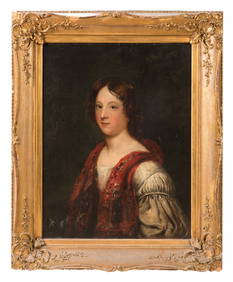
ANTIQUE 18TH C ENGLISH MALE PORTRAIT OIL PAINTINGAntique Arena Inc.4.5(878)See Sold PriceMar 02, 2024
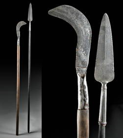
18th C. European Iron Polearms - Spear + BillhookArtemis Fine Arts4.8(1.4k)See Sold PriceFeb 26, 2024
Stanford, Edward 1901 Large Map. Geological Map of the British IslesAlbion Auctions4.7(341)See Sold PriceMar 01, 2024
Stanford, Edward 1901 Large Map. Hydrographical Map of the British IslesAlbion Auctions4.7(341)See Sold PriceMar 01, 2024
Stanford, Edward 1901 Large Map. Stereographical Map of The British IslesAlbion Auctions4.7(341)See Sold PriceMar 01, 2024
Paterson & Mogg 1822 Pair of British Road Maps. Isle of Thanet & WightAlbion Auctions4.7(341)See Sold PriceMar 01, 2024
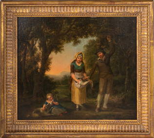
18th/19th C European Oil on Canvas PaintingAntiques Online Auctions4.6(415)See Sold PriceMar 14, 2024
18th/19th C European Oil on Canvas PaintingAntiques Online Auctions4.6(415)See Sold PriceMar 14, 2024
18th/19th C European Oil on Copper or Metal PaintingAntiques Online Auctions4.6(415)See Sold PriceMar 14, 2024
18th/19th C European Oil on Metal Religious PaintingAntiques Online Auctions4.6(415)See Sold PriceMar 14, 2024
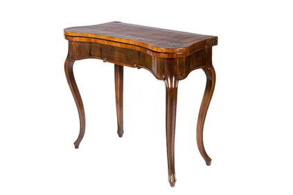
18th C NORTHERN EUROPEAN MIXED WOOD GAMES TABLEA.H. Wilkens Auctions & Appraisals4.7(396)See Sold PriceFeb 28, 2024


![De Jode, Rare, pub. 1593 - Map of the British Isles [England, Scotland, Ireland] (Angliae Scotiae et (1 of 2)](https://p1.liveauctioneers.com/6581/319571/171593327_1_x.jpg?height=282&quality=70&version=1707853304)