ATLAS of ANTIENT GEOGRAPHY by SAMUEL BUTLER 1843John McInnis Auctioneers,LLC4.5(505)See Sold PriceFeb 24, 2024
18TH C. ANTIQUE MAP: FRENCH & INDIAN WAR, FRAMEDThomaston Place Auction Galleries4.4(393)See Sold PriceFeb 24, 2024
Rand McNally Railroad Map Cabinet w/ 21 Railroad MapsRail & Road Auctions4.6(165)See Sold PriceMar 08, 2024
Keith Haring - Ink on New York Map, Best Buddies, Inscribed, Signed, and DatedSapphire Auction Gallery4(67)See Sold PriceMar 02, 2024
LATE 17TH C. FRENCH MAP OF THE NEW WORLD BY ALEXIS-HUBERT JAILLOT (1632-1712)Thomaston Place Auction Galleries4.4(393)See Sold PriceFeb 24, 2024
Central Railroad of New Jersey Map of Sandy Hook Route-ca. 1903JM Hobby Supply and Railroad Artifact Auctions4.4(127)See Sold PriceFeb 24, 2024
Lot of Six Mixed Atlas Box Cars-HO Scale-New in BoxJM Hobby Supply and Railroad Artifact Auctions4.4(127)See Sold PriceFeb 25, 2024
Rand McNally/Santa Fe Railroad Map of Iowa-1912JM Hobby Supply and Railroad Artifact Auctions4.4(127)See Sold PriceFeb 24, 2024
NICOLAES VISSCHER (NETHERLANDS, 1618-1709) MAP OF THE NEW WORLDThomaston Place Auction Galleries4.4(393)See Sold PriceFeb 24, 2024
17TH C. WORLD MAP BY NICOLAES VISSCHER (NETHERLANDS, 1618-1709)Thomaston Place Auction Galleries4.4(393)See Sold PriceFeb 24, 2024
Lot of Six Mixed Atlas Cabooses-HO Scale-New in BoxJM Hobby Supply and Railroad Artifact Auctions4.4(127)See Sold PriceFeb 25, 2024
EASTERN EUROPE. Showing Railways & steamship routes.TITLE/CONTENT OF MAP: 'Central & Western Europe (Railways)' DATE: 1920 IMAGE SIZE: Approx 33.0 x 22.5cm, 13 x 8.75 inches (Large) TYPE: Vintage colour map CONDITION: Good; suitable for framing. HoweveSee Sold Price
EUROPE. Showing railways telegraph cables steamship routes canals 1920 old mapTITLE/CONTENT OF MAP: 'RUSSIA IN EUROPE, PART V., Vilna Grodno Volhynia Podolva Minsk Kiev Tchernigov Smolensk' DATE PRINTED: 1845 IMAGE SIZE: Approx 41.0 x 34.5cm, 16.25 x 13.5 inches (Large) TYPE: ASee Sold Price
WESTERN EUROPE. Showing railways cables steamshipTITLE/CONTENT OF MAP: 'Europe (General)' DATE: 1920 IMAGE SIZE: Approx 33.0 x 22.0cm, 13 x 8.75 inches (Large) TYPE: Vintage colour map CONDITION: Good; suitable for framing. However, please note: TheSee Sold Price
EUROPE. Showing railways telegraph cables steamshipTITLE/CONTENT OF MAP: 'Europe (General); Inset Density of Population ' DATE: 1920 IMAGE SIZE: Approx 34.0 x 45.0cm, 13.25 x 17.5 inches (Large) TYPE: Vintage colour map CONDITION: Good; suitable for fSee Sold Price
MEDITERRANEAN & BLACK SEAS showing steamship routes & railways 1911 old mapTITLE OF THE MAP: 'The Mediterranean; Inset Canary Islands' DATE PRINTED: 1911 IMAGE SIZE: Approx 27.0 x 51.0cm, 10.75 x 20 inches (Large); Please note that this is a folding map. TYPE: Antique colourSee Sold Price
MEDITERRANEAN & BLACK SEAS showing steamship routes & railways 1911 old mapTITLE OF THE MAP: 'The Mediterranean; Inset Canary Islands' DATE PRINTED: 1911 IMAGE SIZE: Approx 27.0 x 51.0cm, 10.75 x 20 inches (Large); Please note that this is a folding map. TYPE: Antique colourSee Sold Price
EUROPE RAILWAYS. double & single track. Narrow gauge. Steamship routes 1920 mapTITLE/CONTENT OF MAP: 'Central & Western Europe (Railways)' DATE PRINTED: 1920 IMAGE SIZE: Approx 34.0 x 45.0cm, 13.25 x 17.5 inches (Large) TYPE: Vintage colour map CONDITION: Good; suitable for framSee Sold Price
EUROPE RAILWAYS. double & single track. Narrow gauge. Steamship routes 1920 mapTITLE/CONTENT OF MAP: 'Europe, Ethnographic' DATE PRINTED: 1952 IMAGE SIZE: Approx 21.5 x 34.0cm, 8.5 x 13.25 inches (Large) TYPE: Vintage colour map; Scale 1:15,000,000 CONDITION: Good; suitable forSee Sold Price
Italian Lines. Mediterranean Map Showing Steamship,Title: Italian Lines. Mediterranean Map Showing Steamship, Railway and Air Routes (Distances in Miles and Kilometers) Cartographer: Publisher: INSTITUTO ITALIANO D'ARTI GRAFICHE Brief Description: EdiSee Sold Price
MacDoanld Gill Canada and Newfoundland, pictorialMacDonald Gill Canada and Newfoundland, pictorial map showing natural and industrial resources, original poster printed by AC Ltd - 51 x 76 cm, Canadian Pacific Map of Railway Steamship routes etc 193See Sold Price
The Hotels of Europe, America, Asia, Austrasia & AfricaThe Hotels of Europe, America, Asia, Austrasia & Africa. With maps and railway and steamship routes. London, J. P. Segg, 1896. Grand in-8, cartonnage d'édition pleine percaline rouge, tranches doréeSee Sold Price
JAPAN KOREA TAIWAN. Railways steamship routes. Chosen.TITLE/CONTENT OF MAP: 'Japan; Inset Tokyo; Lushun; Hokkaido; Japan; Taiwan' DATE PRINTED: 1920 IMAGE SIZE: Approx 34.0 x 45.0cm, 13.25 x 17.5 inches (Large) TYPE: Vintage colour map CONDITION: Good; sSee Sold Price
SoldMap of Hawaii with steamship routesHeading: (Hawaii) Author: Title: Map of Hawaiian Islands showing steamship routes of the Inter-Island Steam Navigation Co., Limited Place Published: Honolulu, Hawaii Publisher:Inter-Island Steam NaviSee Sold Price
SoldBartholomew, John 1904 Lot of 4 Railway Maps UK IrelandRailways of Scotland, Ireland, England & Wales, and General Map of the British Isles with Railway & Steamship Routes. Lithograph Map Published 1904, London for "The Survey Gazetteer of the British IslSee Sold Price
Map of Hawaii with steamship routesHeading: (Hawaii) Author: Title: Map of Hawaiian Islands showing steamship routes of the Inter-Island Steam Navigation Co., Limited Place Published: Honolulu, Hawaii Publisher:Inter-Island Steam NaviSee Sold Price
SoldMAP MEXICAN CENTRAL RAILWAY & CONNECTIONS TEXASFramed Map of the Mexican Central Railway and Connections, late 19th c., published by Poole Brothers in Chicago, showing railway routes through Mexico and south Texas, reduced margins, tape repair atSee Sold Price
UNITED STATES. USA. Railways canals steamship routes.TITLE/CONTENT OF MAP: 'United States (General); Inset map of Hawaiian Islands' DATE PRINTED: 1920 IMAGE SIZE: Approx 34.0 x 45.0cm, 13.25 x 17.5 inches (Large) TYPE: Vintage colour map CONDITION: GoodSee Sold Price
Transport Map of Central Europe. Railways mail routes. LARGE 1927 oldTITLE/CONTENT OF MAP: 'Prémière partie de la carte d'Europe contenant La France, L'Alemagne, L'Italie, L'Espagne, & les Isles Britanniq.s. Publiée sous les auspices de Monseigneur LouisSee Sold Price
ITALY SOUTH. Provinces railways roads steamship routes.TITLE/CONTENT OF MAP: 'Italy (South); Inset map of Palermo ' DATE PRINTED: 1920 IMAGE SIZE: Approx 34.0 x 45.0cm, 13.25 x 17.5 inches (Large) TYPE: Vintage colour map CONDITION: Good; suitable for fraSee Sold Price
SoldTransport Map of Central Europe. Railways mail routes. LARGE 1959 oldTITLE/CONTENT OF MAP: 'Transport Map of Central Europe' DATE PRINTED: 1959 IMAGE SIZE: Approx 49.5 x 72.0cm, 19.5 x 28.25 inches (Large); Please note that this is a folding map. TYPE: Antique colour mSee Sold Price
Transport Map of Central Europe. Railways mail routes. LARGE 1952 oldTITLE/CONTENT OF MAP: British Isles - Railways [inset Glasgow District; Edinburgh District; Leeds District; Liverpool & Manchester District; Birmingham District; Nottingham District; Potteries DistricSee Sold Price
ITALY SOUTH. Provinces railways roads steamship routes.TITLE/CONTENT OF MAP: 'Italy (South); Inset map of Palermo ' DATE: 1920 IMAGE SIZE: Approx 34.0 x 45.0cm, 13.25 x 17.5 inches (Large) TYPE: Vintage colour map CONDITION: Good; suitable for framing. HoSee Sold Price
Transport Map of Central Europe. Railways mail routes.TITLE/CONTENT OF MAP: 'Transport Map of Central Europe' DATE PRINTED: 1952 IMAGE SIZE: Approx 49.5 x 72.0cm, 19.5 x 28.25 inches (Large); Please note that this is a folding map. TYPE: Antique colour mSee Sold Price
SoldA large linen backed map of Europe by Octavia & Co,A large linen backed map of Europe by Octavia & Co, Vienna 1856, 98 x 209cm, Bradshaws 'Map of Europe'; showing the railways opened and in progress , linen backed, no date. C Smith's 'Map of France' LSee Sold Price
Lake Superior and Mississippi River RR 1869 Seven Percent Bonds Book/Report-1869JM Hobby Supply and Railroad Artifact Auctions4.4(127)See Sold PriceFeb 24, 2024
Union Pacific RR Map of the United States-1926JM Hobby Supply and Railroad Artifact Auctions4.4(127)See Sold PriceFeb 24, 2024
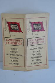
Wabash RR 1907 Jamestown Exposition BrochureJM Hobby Supply and Railroad Artifact Auctions4.4(127)See Sold PriceFeb 24, 2024
Chicago and Eastern Illinois RY Porcelain SpittoonJM Hobby Supply and Railroad Artifact Auctions4.4(127)See Sold PriceFeb 24, 2024
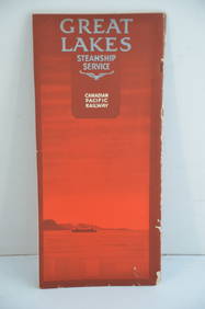
Canadian Pacific RY Great Lakes Steamship 1919 Brochure and TimetableJM Hobby Supply and Railroad Artifact Auctions4.4(127)See Sold PriceFeb 24, 2024
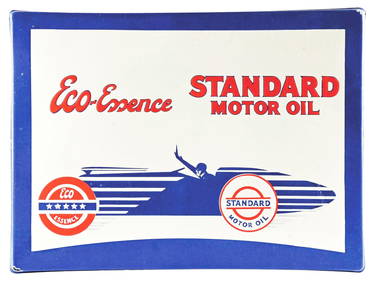
STANDARD MOTOR OIL "ECO-ESSENCE" PORCELAIN SIGN W/ RACE CAR GRAPHIC.Dan Morphy Auctions4.2(1.3k)See Sold PriceFeb 24, 2024
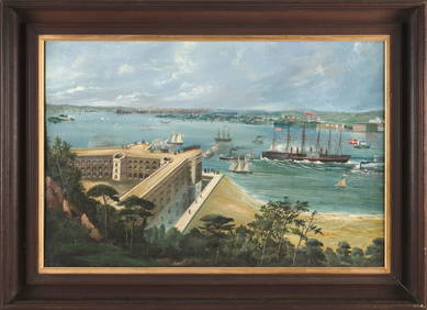
AMERICAN SCHOOL (19th Century,), "Great Eastern Steamship Coming up the Narrows Into the Harbor ofEldred's4.7(419)See Sold PriceFeb 27, 2024
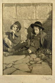
Signed Photo - Jewish Children at the Street - 1910Levy Auction House4.3(11)See Sold PriceFeb 27, 2024
Polish Jews Immigration to America - Lithograph SetLevy Auction House4.3(11)See Sold PriceFeb 27, 2024
Group of 10 Railroad Dining Car Menus and Checks - Southern, Chesapeake & Ohio, Burlington Route,Rail & Road Auctions4.6(165)See Sold PriceMar 07, 2024
Antique Red Silk Robe, Possibly Roma People, Eastern Europe or Middle EastMaterial Culture4.6(778)See Sold PriceFeb 29, 2024
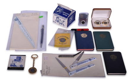
Fifteen Cotton Belt Route Advertising Items - Lighters, Cufflinks, Water Box, Pocket Knife, and MoreRail & Road Auctions4.6(165)See Sold PriceMar 08, 2024
Railways & Transport.- [Prospectus] The Dorking, Brighton, and Arundel Atmospheric Railway, byForum Auctions4.3(53)See Sold PriceFeb 29, 2024
Russian Enamel - Inkwell, Blotter, Spoon, & CandlestickArtemis Fine Arts4.8(1.4k)See Sold PriceFeb 26, 2024
A RARE AND IMPORTANT CHARITY CONTAINER. New York, c.1925. Collecting funds for Chevra Tomchei TorahJ. Greenstein & Co., Inc.4.2(55)See Sold PriceApr 16, 2024


![Railways & Transport.- [Prospectus] The Dorking, Brighton, and Arundel Atmospheric Railway, by (1 of 1)](https://p1.liveauctioneers.com/5458/319736/171654703_1_x.jpg?height=282&quality=70&version=1708010439)