ATLAS of ANTIENT GEOGRAPHY by SAMUEL BUTLER 1843John McInnis Auctioneers,LLC4.5(505)See Sold PriceFeb 24, 2024
18TH C. ANTIQUE MAP: FRENCH & INDIAN WAR, FRAMEDThomaston Place Auction Galleries4.4(393)See Sold PriceFeb 24, 2024
Rand McNally Railroad Map Cabinet w/ 21 Railroad MapsRail & Road Auctions4.6(165)See Sold PriceMar 08, 2024
Keith Haring - Ink on New York Map, Best Buddies, Inscribed, Signed, and DatedSapphire Auction Gallery4(67)See Sold PriceMar 02, 2024
LATE 17TH C. FRENCH MAP OF THE NEW WORLD BY ALEXIS-HUBERT JAILLOT (1632-1712)Thomaston Place Auction Galleries4.4(393)See Sold PriceFeb 24, 2024
Central Railroad of New Jersey Map of Sandy Hook Route-ca. 1903JM Hobby Supply and Railroad Artifact Auctions4.4(127)See Sold PriceFeb 24, 2024
Lot of Six Mixed Atlas Box Cars-HO Scale-New in BoxJM Hobby Supply and Railroad Artifact Auctions4.4(127)See Sold PriceFeb 25, 2024
Rand McNally/Santa Fe Railroad Map of Iowa-1912JM Hobby Supply and Railroad Artifact Auctions4.4(127)See Sold PriceFeb 24, 2024
NICOLAES VISSCHER (NETHERLANDS, 1618-1709) MAP OF THE NEW WORLDThomaston Place Auction Galleries4.4(393)See Sold PriceFeb 24, 2024
17TH C. WORLD MAP BY NICOLAES VISSCHER (NETHERLANDS, 1618-1709)Thomaston Place Auction Galleries4.4(393)See Sold PriceFeb 24, 2024
Lot of Six Mixed Atlas Cabooses-HO Scale-New in BoxJM Hobby Supply and Railroad Artifact Auctions4.4(127)See Sold PriceFeb 25, 2024
MEDITERRANEAN & BLACK SEAS showing steamship routes & railways 1911 old mapTITLE OF THE MAP: 'The Mediterranean; Inset Canary Islands' DATE PRINTED: 1911 IMAGE SIZE: Approx 27.0 x 51.0cm, 10.75 x 20 inches (Large); Please note that this is a folding map. TYPE: Antique colourSee Sold Price
MEDITERRANEAN & BLACK SEAS showing steamship routes & railways 1911 old mapTITLE OF THE MAP: 'The Mediterranean; Inset Canary Islands' DATE PRINTED: 1911 IMAGE SIZE: Approx 27.0 x 51.0cm, 10.75 x 20 inches (Large); Please note that this is a folding map. TYPE: Antique colourSee Sold Price
Italian Lines. Mediterranean Map Showing Steamship,Title: Italian Lines. Mediterranean Map Showing Steamship, Railway and Air Routes (Distances in Miles and Kilometers) Cartographer: Publisher: INSTITUTO ITALIANO D'ARTI GRAFICHE Brief Description: EdiSee Sold Price
EUROPE. Showing railways telegraph cables steamship routes canals 1920 old mapTITLE/CONTENT OF MAP: 'RUSSIA IN EUROPE, PART V., Vilna Grodno Volhynia Podolva Minsk Kiev Tchernigov Smolensk' DATE PRINTED: 1845 IMAGE SIZE: Approx 41.0 x 34.5cm, 16.25 x 13.5 inches (Large) TYPE: ASee Sold Price
SoldMEDITERRANEAN SEA. Submarine telegraph cables. steamship routes. LOWRY 1863 mapTITLE/CONTENT OF MAP: 'Map of the Mediterranean and Adjacent Countries (on Mercator's Projection) Shewing the Submarine Telegraph Cables, and Lengths of the principal Steam Routes' DATE PRINTED: 1863See Sold Price
Sea & rail routes between Asia & Europe. Trans-Siberian railway 1913 old mapTITLE/CONTENT OF MAP: 'General Map of the Trans-Continental Routes between Asia and Europe' DATE PRINTED: 1913 IMAGE SIZE: Approx 34.0 x 44.0cm, 13.25 x 17.5 inches (Large); Please note that this is aSee Sold Price
Sea & rail routes between Asia & Europe. Trans-Siberian railway 1913 old mapTITLE/CONTENT OF MAP: 'General Map of the Trans-Continental Routes between Asia and Europe' DATE PRINTED: 1913 IMAGE SIZE: Approx 34.0 x 44.0cm, 13.25 x 17.5 inches (Large); Please note that this is aSee Sold Price
Mediterranean & Black Seas. Lighthouses. AdmiraltyTITLE/CONTENT OF MAP: 'Mediterranean and Black Seas' The top image on the right hand side shows the entire map. To view a close up of the map showing the level of printed detail, please click on the bSee Sold Price
SoldMediterranean & Black Sea. Cables & Wireless Stations. Land visibility 1918 mapTITLE/CONTENT OF MAP: 'The Mediterranean and Black Sea - Cables and Wireless Stations; Inset The Mediterranean and Black Seas showing the Visibility of the Land' DATE PRINTED: 1918 IMAGE SIZE: ApproxSee Sold Price
SoldMediterranean & Black Sea. Cables & Wireless Stations.TITLE/CONTENT OF MAP: 'The Mediterranean and Black Sea - Cables and Wireless Stations; Inset The Mediterranean and Black Seas showing the Visibility of the Land' DATE PRINTED: c1914 IMAGE SIZE: ApproxSee Sold Price
EASTERN EUROPE. Showing Railways & steamship routes.TITLE/CONTENT OF MAP: 'Central & Western Europe (Railways)' DATE: 1920 IMAGE SIZE: Approx 33.0 x 22.5cm, 13 x 8.75 inches (Large) TYPE: Vintage colour map CONDITION: Good; suitable for framing. HoweveSee Sold Price
East Asia, East Indies & Australasia sea & shipping routes 1920 old mapTITLE/CONTENT OF MAP: 'Map showing the Sea Routes' DATE PRINTED: 1920 IMAGE SIZE: Approx 29.0 x 26.0cm, 11.5 x 10.25 inches (Large); Please note that this is a folding map. TYPE: Antique colour map COSee Sold Price
East Asia, East Indies & Australasia sea & shipping routes 1920 old mapTITLE/CONTENT OF MAP: 'Map showing the Sea Routes' DATE PRINTED: 1920 IMAGE SIZE: Approx 29.0 x 26.0cm, 11.5 x 10.25 inches (Large); Please note that this is a folding map. TYPE: Antique colour map COSee Sold Price
MacDoanld Gill Canada and Newfoundland, pictorialMacDonald Gill Canada and Newfoundland, pictorial map showing natural and industrial resources, original poster printed by AC Ltd - 51 x 76 cm, Canadian Pacific Map of Railway Steamship routes etc 193See Sold Price
Map of NEW ZEALAND, Railway Steamer Routes 1912 old mapTITLE/CONTENT OF MAP: 'Map of New Zealand showing Railway, Steamer, and Coach Routes. Game Seasons' DATE: 1912 IMAGE SIZE: Approx 55.5 x 40.0cm, 21.75 x 15.75 inches (Large); Please note that this isSee Sold Price
SoldThe Mediterranean, Seaports and Sea Routes by BaedekerHandbook for travelers with 38 fold-out maps and 49 plans. 1st edition Guide Book published 1911 Leipzig: Karl Baedeker, publisher. London: T. Fisher Unwin, 1 Adelphi Terrace, W.C., New York: CharlesSee Sold Price
Cary (John) A New Map of Turkey in AsiaCary (John) A New Map of Turkey in Asia, showing the Eastern Mediterranean with Cyprus, and the Black Sea, engraved map with full original hand-colouring, 515 x 570mm., central vertical fold,See Sold Price
SoldKarl BAEDEKER - The Mediterranean. Seaports and sea rouKarl BAEDEKER - The Mediterranean. Seaports and sea routes including Madeira, The Canary Islands, The Coast of Morocco, Algeria and Tunisia. With 38 maps and 49 plans. Leipzig, Karl Baedeker, 1911. InSee Sold Price
Karl BAEDEKER - The Mediterranean. Seaports and sea rouKarl BAEDEKER - The Mediterranean. Seaports and sea routes including Madeira, The Canary Islands, The Coast of Morocco, Algeria and Tunisia. With 38 maps and 49 plans. Leipzig, Karl Baedeker, 1911. InSee Sold Price
MAP - France & Mediterranean. Mount & PageSouthern France, Mediterranean. Mount & Page, The Sea Coast of Languedoc, Provence, and Part of Italy; from Cape Dragon, to Cape Delle Melle, 1729 (published). Black & White. This handsome sea chart cSee Sold Price
SoldSOUTHERN STATES TRADE ROUTE MAPLarge Framed Trade Route Map showing waterways and towns from the Mississippi River to Charles Town. Geographic Area Covered: Southern States, South Carolina,Santee River Valley, Savannah River ValleySee Sold Price
SoldInitialed Oil on Canvas Painting of a ShipInitialed oil on canvas painting of a ship, initials to the lower right corner read ‘ZVM’, subject an old ship at sea in rough waters, black and gold painted wooden frame, chips to frame, measuresSee Sold Price
SoldRuger Old Army .45 Caliber Black Powder Revolver S#:7 1/2" Barrel. 6 shot. Bright stainless finish. Faux ivory grips. In factory box . Comes w/ shipping carton and paperwork.See Sold Price
SoldRuger Old Army .45 Caliber Black Powder Revolver S#:7 1/2" Barrel. Bright stainless finish. Has not been fired. In factory box with paper.See Sold Price
Evelyn Metzger (NY,Brazil,1911-2007) oil paintingBroward Auction Gallery4.7(292)See Sold PriceMar 10, 2024
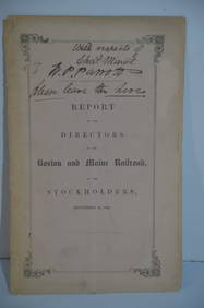
Boston and Maine RR Annual Report-September 12, 1849JM Hobby Supply and Railroad Artifact Auctions4.4(127)See Sold PriceFeb 24, 2024
Crawfordsville and Southwestern RY First Mortgage Bond Prospectus Book-1872JM Hobby Supply and Railroad Artifact Auctions4.4(127)See Sold PriceFeb 24, 2024
Lake Superior and Mississippi River RR 1869 Seven Percent Bonds Book/Report-1869JM Hobby Supply and Railroad Artifact Auctions4.4(127)See Sold PriceFeb 24, 2024
1875 Rand Avery and Co. Map of Express Companies and Railroads of the USA and CanadaJM Hobby Supply and Railroad Artifact Auctions4.4(127)See Sold PriceFeb 24, 2024
Chicago and Northwestern RY Travelers Companion Notebook-1880JM Hobby Supply and Railroad Artifact Auctions4.4(127)See Sold PriceFeb 24, 2024
Chicago Milwaukee and St Paul RY To the Lakes of Wisconsin and Minnesota Book-1909JM Hobby Supply and Railroad Artifact Auctions4.4(127)See Sold PriceFeb 24, 2024
Erie Railway Tourist Book/Magazine-1874JM Hobby Supply and Railroad Artifact Auctions4.4(127)See Sold PriceFeb 24, 2024
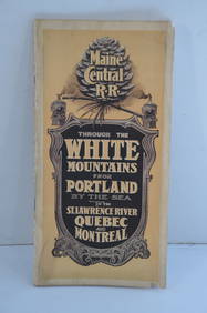
Maine Central RR Through the White Mtns-Portland to the St Lawrence River Book-1901JM Hobby Supply and Railroad Artifact Auctions4.4(127)See Sold PriceFeb 24, 2024
Union Pacific RR Across The Continent West From Omaha, NE Book-April 2, 1868JM Hobby Supply and Railroad Artifact Auctions4.4(127)See Sold PriceFeb 24, 2024
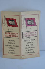
Wabash RR 1907 Jamestown Exposition BrochureJM Hobby Supply and Railroad Artifact Auctions4.4(127)See Sold PriceFeb 24, 2024
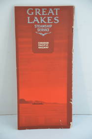
Canadian Pacific RY Great Lakes Steamship 1919 Brochure and TimetableJM Hobby Supply and Railroad Artifact Auctions4.4(127)See Sold PriceFeb 24, 2024
Great Western RY November 1, 1880 Public TimetableJM Hobby Supply and Railroad Artifact Auctions4.4(127)See Sold PriceFeb 24, 2024
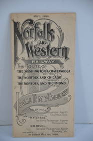
Norfolk and Western RY May 1898 Public TimetableJM Hobby Supply and Railroad Artifact Auctions4.4(127)See Sold PriceFeb 24, 2024
Vintage County Map Of NY State Plate EngravingThe Benefit Shop Foundation Inc.4.3(2.9k)See Sold PriceFeb 28, 2024
Twelve Pieces of Kansas City Southern Railroad China - Demitasse Set, Dinner Plates, Soup Bowl, andRail & Road Auctions4.6(165)See Sold PriceMar 08, 2024