


Popular Searches
Popular Searches

d’Anville: Antique Map of Palestine, 1767
You May Also Like


Similar Sale History
Sold


Sold


1767 d'Anville Map of Ancient Palestine -- Palaestina by Mons. d'Anville of the Royal Academy …Title: 1767 d'Anville Map of Ancient Palestine -- Palaestina by Mons. d'Anville of the Royal Academy … Cartographer: J d'Anville Year / Place: 1767, London Map Dimension (in.): 26.4 x 21.7 in. T
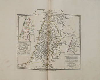
1767 d'Anville Map of Ancient Palestine -- Palaestina by Mons. d'Anville of the Royal Academy …Title: 1767 d'Anville Map of Ancient Palestine -- Palaestina by Mons. d'Anville of the Royal Academy … Cartographer: J d'Anville Year / Place: 1767, London Map Dimension (in.): 26.4 x 21.7 in. T

Sold
![[PALESTINE]. D'Anville. Palaestina. 1767. Dou (1 of 1)](https://p1.liveauctioneers.com/179/10971/2682760_1_x.jpg?height=282&quality=70&version=1162265652)
Sold


Sold

Sold


Sold


Upcoming Sales
View All


TOP