MAP - PIETER SCHENK / VALK / JANSSEN Hand Colored superb Map Central Italy c1702Luis Porretta Fine Arts4.3(10)See Sold PriceMar 02, 2024
CHARLES ROLLIN c1828 Ceasar Hand Colored Africa Military MapLuis Porretta Fine Arts4.3(10)See Sold PriceMar 02, 2024
MAP - Dufour, A. H. ( Malte / Brun ) :MAP - ESPAGNE PARTIE SUD DIVISEE EN PROVINCES ANCIENNES ( MAPLuis Porretta Fine Arts4.3(10)See Sold PriceMar 02, 2024
RIGOBERT BONNE c1787 Original Colored Map Germany & Region 15" x 12"Luis Porretta Fine Arts4.3(10)See Sold PriceMar 02, 2024
AMBROISE TARDIEU c1822 Napoleonic War Map GermanyLuis Porretta Fine Arts4.3(10)See Sold PriceMar 02, 2024
MAP - AMBROISE TARDIEU c1822 Napoleonic Miltary Map GermanyLuis Porretta Fine Arts4.3(10)See Sold PriceMar 02, 2024
1822 Rare Map by Ambroise Tardieu Napoleon Caldiero Battle of Vento 17" x 11Luis Porretta Fine Arts4.3(10)See Sold PriceMar 02, 2024
PIETER SCHENK / VALK / JANSSEN Hand Colored Map of Rhodes Greece ca1702 vgcLuis Porretta Fine Arts4.3(10)See Sold PriceMar 02, 2024
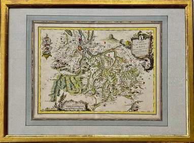
Map: Carte du Canton de Bale, Jacques Clermont, Paris, 1788Kensington Estate Auction4.6(216)See Sold PriceFeb 26, 2024
D'Anville Two-Part Map of EuropeD'ANVILLE, Jean Baptiste Bourguigon (1697-1782). Seconde Partie de la Carte d'Europe contenant le Danemark et la Norwege, la Suéde et la Russie (à l'exception de l'Ukraine) Engraved map. Pairs:See Sold Price
SoldLarge maps by Andriveau-GoujonHeading: Author: Andriveau-Goujon, J. Title: Thirteen large maps, mostly of Europe and the Mediterranean basin, housed in a two-part case with spine label "Atlas de Choix 2" Place Published: Paris PuSee Sold Price
SoldHall and Black Color Map [Russia]Map of Russia (in Europe) engraved by S. Hall. Published by A. and C. Black, Edinburgh, 1850's. Measures 22.25-in. x 17.375-in. sheet size. Map originally in two parts and is now taped on verso into oSee Sold Price
Two historical maps of the 19tTwo historical maps of the 19th century, map of Europe as part col. Steel engraving from: Levasseur ''Atlas National de la France Illustrée'' from 1952, behind glass a. Pp. Ger., As well as ''Map oSee Sold Price
EUROPE AFTER THE CONGRESS OF VIENNA MAPIn two parts by Thomson 1816. Each piece overall size 21 1/2" X 50"See Sold Price
Soldtwo 18th c maps of the African Coasttwo 18th c maps of parts of the African Coast- 1788 copy's of D'Anville Map of the Coast of Guinea,12" x 19", D'Anville Particular map of the Western Coast of Africa, 19 3/4" x 15"See Sold Price
SoldTwo historical maps of the 18th centTwo historical maps of the 18th century, map of Europe ''Europa secundum legitima'', partly col. copper engraving by Homann Erben about 1740, stained, backed and with missing parts at lower margin, anSee Sold Price
SoldCluverius (P) Orbis VeteribusCluverius (Philippus) Orbis Veteribus Noti Tabula Nova, hemisphere of the Old World, showing Europe, Africa, Asia and part of Oceania, engraved map with outline hand-colouring, 380 x 385mm., tSee Sold Price
SoldELGAR EDWARD: (1857-1934)ELGAR EDWARD: (1857-1934) English Composer. A good A.L.S., Edward Elgar, two pages, 4to, Hampstead, 19th September 1920, to Elkin. Elgar states in part `Would you kindly see the enclosed letter. PerhaSee Sold Price
SoldDe l'Isle (G) Turkey, Arabia and PersiaDe l'Isle (Guillaume) A Map Of Turkey, Arabia and Persia, with part of south-eastern Europe and north Africa to the Horn of Africa, decorative title cartouche, with two figures in oriental dreSee Sold Price
TWO-PART MAP OF NEW ENGLANDTWO-PART MAP OF NEW ENGLANDboth by George Gillet, 1821, compiled for President Dwight's travels, including 'Map of the Northern Part of New England', 8-1/2 x 14 in. (sight), and 'Map of the Southern PSee Sold Price
SoldTEXAS TWO PART MAP, 1890, CENTURY COMPANY ATLASFramed map of Texas from the Century Company Atlas, 1890 with copyright 1902, in two parts within the frame, the right with the Eastern part, the left with the Western part of Texas, an inset of GalveSee Sold Price
Circa 1732 Two-Part Map of South America. OriginaCirca 1732 Two-Part Map of South America. Original Color. Both in One Frame. Mapmaker Moll. Framed, Museum Glass, and Acid Free Mattes. Dimensions: 7.25" x 13" eachSee Sold Price
[THOMSON] Two part map of Ireland, c. 1800Two part map of Ireland, c. 1800, Hand-coloured map. Original colouring. Engraved for Thomson's New General Atlas. Hand-coloured with cartouche on both maps (68 cm. wide; 54 cm. high each, approx.). GSee Sold Price
SoldTwo hand colored two part maps of Rockefellerland toTwo hand colored two part maps of Rockefellerland to include Pocantico Hills New York, Westchester County and Area for Early Action. 45" x 39 1/2" each Provenance: Estate of Peggy & David RockefellerSee Sold Price
TWO-PART MAP OF NEW ENGLANDboth by George Gillet, 1821, compiled for President Dwight's travels, including 'Map of the Northern Part of New England', 8-1/2 x 14 in. (sight), and 'Map of the Southern Part of New England', 11-1/2See Sold Price
TWO-PART MAP OF NEW ENGLANDboth by George Gillet, 1821, compiled for President Dwight's travels, including 'Map of the Northern Part of New England', 8-1/2 x 14 in. (sight), and 'Map of the Southern Part of New England', 11-1/2See Sold Price
Sold18th Century French Two-Part Map of the West AfricanBonne, Rigobert. Carte De La Guin̩e, Paris, 1771, copperplate engravings with outline color. Presented in later wooden frames. DOA 21.5 x 16.75 in. From the Collection of Colette Gaudron, SoutheastSee Sold Price
Sold17th Century Map by BlaeuTwo-part map titled "Perchensis Comitatus" and "Comitatus Blesensis" by Blaeu. Map measures 19.5" x 23" and is hand-colored. Map exhibits foxing, toning, and some minor edge chips with text on reverseSee Sold Price
Sold16thC "Abraham Ortelius" Map of Ancient Belgium and16thC "Abraham Ortelius" Map of Ancient Belgium and English Coast, Engraved two part map with hand color, 1624 paragon edition, 15 5/8" x 19 3/4" sight, matted and framed under glass (double sided) toSee Sold Price
SoldA 1745 DE L'ISLE MAP OF RUSSIA AND UKRAINEA 1745 DE L'ISLE MAP OF RUSSIA AND UKRAINE. Comprising a two-part map entitled "Carte de Moscovie" by French cartographer Guillaume de L'isle. The top sheet depicts the area from the White Sea, in thSee Sold Price
SoldBritish Army tubular leather map case, WW1British Army issue tubular leather map case, comprising telescopic two part map case with carrying handles at each end. Its large size indicates use at battalion [or a higher formation] H.Q. Overall lSee Sold Price
SoldFrance.- Paris.- SDUK (Society for the Diffusion ofFrance.- Paris.- SDUK (Society for the Diffusion of Useful Knowledge) Western Division of Paris. Containing the Quartiers; Eastern Division of Paris. Containing the Quartiers, two-part map, engravingSee Sold Price
SoldMiddle East.- Cassini (Giovanni Maria) Gli ImperiMiddle East.- Cassini (Giovanni Maria) Gli Imperi Antichi Parte Occidentale; Gli Imperi Antichi Parte Orientale, two part map of the Turkish Empire, showing Greece, Asia Minor, the Holy Land, Egypt, tSee Sold Price
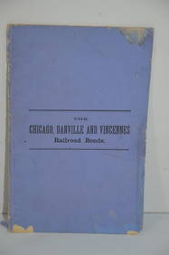
Chicago Danville and Vincennes RR Gold Bond Prospectus Book-1872JM Hobby Supply and Railroad Artifact Auctions4.4(126)See Sold PriceFeb 24, 2024
18TH C. ANTIQUE MAP: FRENCH & INDIAN WAR, FRAMEDThomaston Place Auction Galleries4.4(386)See Sold PriceFeb 24, 2024
Hand Colored Map of the city of Amsterdam 1720Global Auctions Company4.3(36)See Sold PriceMar 03, 2024
Hand Colored Engraved Map of Europe, Jean Baptiste Bourguignon Anville 1754Global Auctions Company4.3(36)See Sold PriceMar 03, 2024
Two (2) Antique 18th C. Copper Engraved Framed Maps - America & EuropeMagnusson Art Group4.5(46)See Sold PriceMar 14, 2024
Carey, pub. 1796 - Map of the Tennassee State formerly part of North Carolina (Tennessee)Trillium Antique Prints & Rare Books4.5(30)See Sold PriceFeb 24, 2024
1816 MAP SOUTHERN PART OF RUSSIA or MUSCOVY in EUROPE copper engraving ANTIQUEJasper524.5(9.8k)See Sold PriceFeb 27, 2024
1816 MAP NORTHERN PART OF RUSSIA or MUSCOVY in EUROPE copper engraving ANTIQUEJasper524.5(9.8k)See Sold PriceFeb 27, 2024
1704 DESCRIPTION OF ALL THE SEATS OF THE PRESENT WARS OF EUROPE antique w/ MAPSJasper524.5(9.8k)See Sold PriceFeb 27, 2024
Map of Part of the West Indies, Etc., Showing the Exact Position Of The U.S. War Steamer SanJasper524.5(9.8k)See Sold PriceFeb 27, 2024
ROSSINI GIOACCHINO: (1792-1868)International Autograph Auctions Europe S.L.4.5(52)See Sold PriceMar 13, 2024
GROUCHY EMMANUEL DE: (1766-1847)International Autograph Auctions Europe S.L.4.5(52)See Sold PriceMar 14, 2024
ISABELLA II: (1830-1904)International Autograph Auctions Europe S.L.4.5(52)See Sold PriceMar 14, 2024
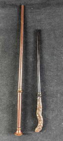
Harry Potter Interactive Oak & Hazel Wands Universal StudiosRapid Estate Liquidators and Auction Gallery4.5(1.1k)See Sold PriceFeb 27, 2024


![Hall and Black Color Map [Russia] (1 of 2)](https://p1.liveauctioneers.com/5755/147592/74586288_1_x.jpg?height=282&quality=70&version=1565308983)


![[THOMSON] Two part map of Ireland, c. 1800 (1 of 2)](https://p1.liveauctioneers.com/1187/57305/28080914_1_x.jpg?height=282&quality=70&version=1403622104)