ATLAS of ANTIENT GEOGRAPHY by SAMUEL BUTLER 1843John McInnis Auctioneers,LLC4.5(505)See Sold PriceFeb 24, 2024
18TH C. ANTIQUE MAP: FRENCH & INDIAN WAR, FRAMEDThomaston Place Auction Galleries4.4(393)See Sold PriceFeb 24, 2024
Rand McNally Railroad Map Cabinet w/ 21 Railroad MapsRail & Road Auctions4.6(165)See Sold PriceMar 08, 2024
Keith Haring - Ink on New York Map, Best Buddies, Inscribed, Signed, and DatedSapphire Auction Gallery4(67)See Sold PriceMar 02, 2024
LATE 17TH C. FRENCH MAP OF THE NEW WORLD BY ALEXIS-HUBERT JAILLOT (1632-1712)Thomaston Place Auction Galleries4.4(393)See Sold PriceFeb 24, 2024
Central Railroad of New Jersey Map of Sandy Hook Route-ca. 1903JM Hobby Supply and Railroad Artifact Auctions4.4(127)See Sold PriceFeb 24, 2024
Lot of Six Mixed Atlas Box Cars-HO Scale-New in BoxJM Hobby Supply and Railroad Artifact Auctions4.4(127)See Sold PriceFeb 25, 2024
Rand McNally/Santa Fe Railroad Map of Iowa-1912JM Hobby Supply and Railroad Artifact Auctions4.4(127)See Sold PriceFeb 24, 2024
NICOLAES VISSCHER (NETHERLANDS, 1618-1709) MAP OF THE NEW WORLDThomaston Place Auction Galleries4.4(393)See Sold PriceFeb 24, 2024
17TH C. WORLD MAP BY NICOLAES VISSCHER (NETHERLANDS, 1618-1709)Thomaston Place Auction Galleries4.4(393)See Sold PriceFeb 24, 2024
Lot of Six Mixed Atlas Cabooses-HO Scale-New in BoxJM Hobby Supply and Railroad Artifact Auctions4.4(127)See Sold PriceFeb 25, 2024
Covens and Mortier: Antique World Map, 1745Title/Content of Map: 1745 Covens and Mortier World Map -- Mappe-Monde Dressee sur les Observations de Mrs. de l'Academie Royale des Sciences et Quelques Autres et sur les Memoires les Plus Recens DatSee Sold Price
Covens & Mortier: Map of the World Map, 1745Map: 1745 Covens and Mortier World Map -- Mappe-Monde Dressee sur les Observations de Mrs. de l'Academie Royale des Sciences et Quelques Autres et sur les Memoires les Plus Recens Cartographer: CovensSee Sold Price
Covens & Mortier: Antique Map of the World, 1745Map: 1745 Covens and Mortier World Map -- Mappe-Monde Dressee sur les Observations de Mrs. de l'Academie Royale des Sciences et Quelques Autres et sur les Memoires les Plus Recens Cartographer: CovensSee Sold Price
Sold1745 Covens and Mortier World Map -- Mappe-MondeTitle/Content of Map: 1745 Covens and Mortier World Map -- Mappe-Monde Dressee sur les Observations de Mrs. de l'Academie Royale des Sciences et Quelques Autres et sur les Memoires les Plus Recens DatSee Sold Price
1745 Covens and Mortier World Map -- Mappe-MondeTitle/Content of Map: 1745 Covens and Mortier World Map -- Mappe-Monde Dressee sur les Observations de Mrs. de l'Academie Royale des Sciences et Quelques Autres et sur les Memoires les Plus Recens DatSee Sold Price
1745 Covens and Mortier World Map -- Mappe-MondeTitle/Content of Map: 1745 Covens and Mortier World Map -- Mappe-Monde Dressee sur les Observations de Mrs. de l'Academie Royale des Sciences et Quelques Autres et sur les Memoires les Plus Recens DatSee Sold Price
1745 Covens and Mortier World Map -- Mappe-MondeTitle/Content of Map: 1745 Covens and Mortier World Map -- Mappe-Monde Dressee sur les Observations de Mrs. de l'Academie Royale des Sciences et Quelques Autres et sur les Memoires les Plus Recens DatSee Sold Price
SoldLes Principales Forteresses Ports...Les Principales Forteresses Ports & de L'Amerique SeptentrionaleHenry Popple (d. 1743). Engraved map with original hand-color in outline. Amsterdam: Covens & Mortier, c. 1745. 21 5/8 x 26 1/8 inches.See Sold Price
Sold9 European Maps, Fricx, 18th CenturyAfter Eugene Henri Fricx (France, 1644-1730), nine (9) engraved European maps, published c. 1745, from Covens and Mortier's "ATLAS DES PAYS BAS...." Some of the maps first appeared in Eugene Fricx's TSee Sold Price
1745 In Notitiam Ecclesiasticam Africae TabulaBy: Jean Covens & Corneille Mortier Date: 1745 (circa) Amsterdam Dimensions: 15.5 x 20.75 inches (39.4 x 52.7 cm) This is an authentic antique map of Northern Africa, the Mediterranean, and Southern ESee Sold Price
Delisle, Guillaume Atlas NouveauContenant toutes les parties du Monde. Ou sont exactement Remarquées les Empires, Monarchies, Royaumes, Etats, Republiques &c., Amsterdam: Jean Covens & Corneille Mortier, [c.1745]. Folio, (530 xSee Sold Price
SoldDelisle, Guillaume Atlas NouveauContenant toutes les parties du Monde. Ou sont exactement Remarquées les Empires, Monarchies, Royaumes, Etats, Republiques &c., Amsterdam: Jean Covens & Corneille Mortier, [c.1745]. Folio, (530 x 3See Sold Price
SoldMap, ''Plan De La Ville de Douay...''Antiquarian map, ''Plan De La Ville de Douay et du Fort D'Escarpe...'', published by Jean Covens & Corneille Mortier, Amsterdam, circa 1745, depicts the fortifications of the town of Douay, sight: 22See Sold Price
SoldMap, ''Plan de Bethune''Antiquarian map, ''Plan de Bethune'', published by Jean Covens & Corneille Mortier, Amsterdam, circa 1745, depicts the fortifications of the town of Bethune, France, sight: 19 1/2''w x 15 1/2''hSee Sold Price
SoldTwo historical maps of HannovTwo historical maps of Hannover and Lüneburg, ''L'Electorat de Hannover'', part col. Engraving by Covens & Mortier in Amsterdam, dated 1745, with the area of the mouth of the Elbe, Minden, Kassel aSee Sold Price
MAP - Middle East. DelisleEastern Mediterranean & Middle East. Delisle/Covens & Mortier, Alexandri Magni Imperium et Expeditio Tabula Conspectum Exhibens Regionum Omnium quas Alexander Dario & Regibus Indorum..., 1745 (circa).See Sold Price
1745 Nova et Accurata Regni Hungariae Tabula, ad UsumBy: I. Covens and C. Mortier par Guillaume de l’IsleDate: 1745 (published) AmsterdamDimensions: 19 x 22.5 inches (48.3 cm x 57.2 cm)Description: This authentic antique hand colored map by I.CovSee Sold Price
SoldCovens & Mortier Map of the World ca. 1700 CalifoJohannes Covens (1697-1774) and Cornelius Mortier (1699-1783), "Carte Generale du Monde, ou Description du Monde Terrestre & Aquatique," Amsterdam, ca. 1700. This map of the world shows California asSee Sold Price
SoldCovens & Mortier Map of Peru Brazil & Amazon 1730Covens and Mortier Map of Brazil & the Amazon Region, 1730. Map titled "Tabula Geographica Peruae, Braziliae & Amazonum Regionis" Map measures 24.5" x 20.25" sheet size. Unframed, loose and not gluedSee Sold Price
SoldA Covens & Mortier Map of North America.A Covens & Mortier Map of North America. Dated 1757 Sight: 18.25" x 24" Frame: 25.25" x 31"See Sold Price
Sold1740 Covens & Mortier Map of Northern Russia in EuropeTitle: 1740 Covens & Mortier Map of Northern Russia in Europe -- Carte de Moscovie Dressee par Guillaume de l'Isle de l'Academie Royale des Sciences a son Excellence Monseigneur Andre Artemonides de MSee Sold Price
Sold1740 Covens & Mortier Map of Biblical Middle East --Title: 1740 Covens & Mortier Map of Biblical Middle East -- Carte de la Situation du Paradis Terrestre, Et des Pais Habitez par les Patriarches Dressee pour bien entendre l'Histoire Sainte, Par MessirSee Sold Price
Covens & Mortier Map of N. America, 1737After DE L'ISLE, Guillaume (1675-1726). L'Amerique Septentrionale. Engraved map with hand color in full. Amsterdam: Covens & Mortier, c. 1737. 21 3/8" x 26 3/8" sheet. A classic map of the Americas. ASee Sold Price
1740 Covens & Mortier Map of Biblical Middle East --Title/Content of Map: 1740 Covens & Mortier Map of Biblical Middle East -- Carte de la Situation du Paradis Terrestre, Et des Pais Habitez par les Patriarches Dressee pour bien entendre l'Histoire SaiSee Sold Price
COVENS & MORTIER 1745 MAP OF THE GLOBEThomaston Place Auction Galleries4.4(393)See Sold PriceFeb 24, 2024
Large Assortment of Railroad Items - Insulators, Globes, Hand Bell, Posters, Maps, Timetables,Rail & Road Auctions4.6(165)See Sold PriceMar 07, 2024
1742 BIBLE in FRENCH antique OLD & NEW TESTAMENT leather boundJasper524.5(9.9k)See Sold PriceFeb 27, 2024
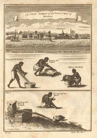
Guinea-Bissau Cacheu town Fortaleza de São José da Amura Preparing cassava 1745Jasper524.5(9.9k)See Sold PriceFeb 28, 2024
West coast of Africa from Cape Blanco… Arguin bay, Mauritania. LABAT 1745 mapJasper524.5(9.9k)See Sold PriceFeb 28, 2024
Coast & Islands between Cape Roxo. Guinea-Bissau & Bissagos. KITCHIN 1745 mapJasper524.5(9.9k)See Sold PriceFeb 28, 2024
La Barbarie de la Nigritie et de la Guinée'. West Africa. DE L’ISLE 1745 mapJasper524.5(9.9k)See Sold PriceFeb 28, 2024
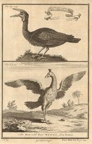
Gambian birds. Monoceros. A bird with four wings. CHILD 1745 old antique printJasper524.5(9.9k)See Sold PriceFeb 28, 2024
East coast of Africa from the Cape… South Africa Mozambique. CHILD 1745 mapJasper524.5(9.9k)See Sold PriceFeb 28, 2024
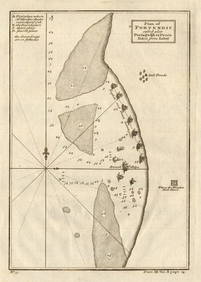
Plan of Portendic… Portu d'Addi or Penia. Portendick Mauritania. LABAT 1745 mapJasper524.5(9.9k)See Sold PriceFeb 28, 2024
Western coast of Africa… to the River Sanaga. Southern Mauritania LABAT 1745 mapJasper524.5(9.9k)See Sold PriceFeb 28, 2024
1742 BIBLE IN FRENCH, ANCIENT, LEATHER-BOUND, OLD AND NEW TESTAMENTNY Elizabeth 4.2(86)See Sold PriceMar 03, 2024


![Vintage Airplane Desk Model [Air France] (1 of 7)](https://p1.liveauctioneers.com/5755/320282/172113951_1_x.jpg?height=282&quality=70&version=1708463029)


