SoldA Covens & Mortier Map of North America.A Covens & Mortier Map of North America. Dated 1757 Sight: 18.25" x 24" Frame: 25.25" x 31"See Sold Price
SoldCa 1780 map Northern North AmericaCa. 1780 A Chorographical map of the Northern Department of North America, Drawn from the latest and most accurate observations at Amsterdam by Covens, Mortier, & Covens Junior. Engraved by H KlockhofSee Sold Price
Moriter Map of North AmericaMORTIER, Pierre (1661-1711) after De L'ISLE, Guillaume (1675 - 1726).L'Amerique Septentrionale. Engraved map, hand color in outline. Amsterdam: 1708. 19 3/4" x 23". Covens & Mortier was one of the larSee Sold Price
Sold(Maps and Charts, North America), Delisle, Guillau(Maps and Charts, North America), Delisle, Guillaume (1675-1726), Carte Particuliere de L'Amerique Septentrionale, Amsterdam: Covens and Mortier [1740], the key map from Atlas Nouveau, showing eighteeSee Sold Price
(Maps and Charts, North America), Delisle, Guillau(Maps and Charts, North America), Delisle, Guillaume (1675-1726), Carte du Canada ou de la Nouvelle France..., [Amsterdam: Jean Covens et Corneille Mortier, c. 1730 or later], double-page folio with hSee Sold Price
Sold(Maps and Charts, North America), Delisle, Guillau(Maps and Charts, North America), Delisle, Guillaume (1675-1726), Carte du Canada ou de la Nouvelle France. . ., [Amsterdam: Jean Covens et Corneille Mortier, c. 1730 or later], double page folio withSee Sold Price
SoldCovens & Mortier ''L'Amerique Septentrionale,'' 1[North America]. Covens & Mortier. L'Amerique Septentrionale Dressee Sur Les Memoires Le Plus Recens Des Meilleurs Geographes...Amst: 1757. Double-page engraved map, early hand-coloring in outline andSee Sold Price
SoldMortier & Covens French edition of MitchellA Map of the British and French Dominions in North America... Cornelis Mortier (1699-1783) & Johannes Covens (1697-1774). Engraved map in 8 parts with original hand color in outline. Amsterdam: CovensSee Sold Price
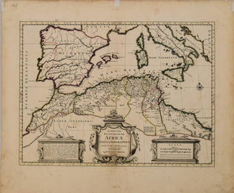
1730 Covens & Mortier Map of North Coast of Africa andTitle: 1730 Covens & Mortier Map of North Coast of Africa and Southern Europe -- In Notitiam Ecclesiasticam Africae Tabula Geographica Cartographer: Covens & Mortier Year / Place: 1730 c., Amsterdam MSee Sold Price
1730 Covens & Mortier Map of North Coast of Africa andTitle: 1730 Covens & Mortier Map of North Coast of Africa and Southern Europe -- In Notitiam Ecclesiasticam Africae Tabula Geographica Cartographer: Covens & Mortier Year/Place: 1730 c., Amsterdam DimSee Sold Price
1730 Covens & Mortier Map of North Coast of Africa andTitle/Content of Map: 1730 Covens & Mortier Map of North Coast of Africa and Southern Europe -- In Notitiam Ecclesiasticam Africae Tabula Geographica Date: 1730 c., Amsterdam Cartographer: Covens & MoSee Sold Price
1730 Covens & Mortier Map of North Coast of Africa and Southern Europe -- In Notitiam EcclesiasticamTitle: 1730 Covens & Mortier Map of North Coast of Africa and Southern Europe -- In Notitiam Ecclesiasticam Africae Tabula Geographica Cartographer: Covens & Mortier Year / Place: 1730 c., Amsterdam MSee Sold Price
1730 Covens & Mortier Map of North Coast of Africa andTitle: 1730 Covens & Mortier Map of North Coast of Africa and Southern Europe -- In Notitiam Ecclesiasticam Africae Tabula Geographica Cartographer: Covens & Mortier Year / Place: 1730 c., Amsterdam MSee Sold Price
1730 Covens & Mortier Map of North Coast of Africa andTitle/Content of Map: 1730 Covens & Mortier Map of North Coast of Africa and Southern Europe -- In Notitiam Ecclesiasticam Africae Tabula Geographica Cartographer: Covens & Mortier Year/Place: 1730 c.See Sold Price
1730 Covens & Mortier Map of North Coast of Africa andTitle: 1730 Covens & Mortier Map of North Coast of Africa and Southern Europe -- In Notitiam Ecclesiasticam Africae Tabula Geographica Cartographer: Covens & Mortier Year / Place: 1730 c., Amsterdam MSee Sold Price
Covens & Mortier Map of N. America, 1737After DE L'ISLE, Guillaume (1675-1726). L'Amerique Septentrionale. Engraved map with hand color in full. Amsterdam: Covens & Mortier, c. 1737. 21 3/8" x 26 3/8" sheet. A classic map of the Americas. ASee Sold Price
SoldPIERRE MORTIER (DUTCH, 1661-1711) MAP OF EASTERN NORTHPIERRE MORTIER (DUTCH, 1661-1711) MAP OF EASTERN NORTH AMERICA, hand-colored, on laid paper, titled to upper margin "CARTE PARTICULIERE DE VIRGINIE, MARYLAND, PENNSILVANIE, La Nouvelle JARSEY Orient eSee Sold Price
SoldEngraved map of America, by Covens & Mortier, AmsEngraved map of America, by Covens & Mortier, Amsterdam, 19'' x 24''.See Sold Price
SoldCARTE DE LA LOUISIANE... Covens & Mortier, 1758.[North America] CARTE DE LA LOUISIANE, MARYLAND, VIRGINIE CAROLINE, GEORGIE, avec une Partie de la Floride. Amst: Covens & Mortier, 1758. At lower left corner of image: “C. Sepp sculpsit.” The towSee Sold Price
SoldCovens & Mortier's map of Caribbean, from PoppleTitle: A Map of the British Empire In America with the French, Spanish and the Dutch Settlements adjacent thereto by Henry Popple Author: Covens & Mortier Description: Copper-engraved map, hand-coloreSee Sold Price
SoldMORTIER'S 1700 MAP OF THE FRENCH AND ENGLISH COLONIESMORTIER'S 1700 MAP OF THE FRENCH AND ENGLISH COLONIES IN NORTH AMERICA PIERRE MORTIER (1661-1711) Carte Nouvelle de l'Amérique Angloise Contenant La Virginie, Mary-Land, Carline, Pennsylvania, NouvSee Sold Price
SoldPierre Mortier (1661-1711), copper engraved handPierre Mortier (1661-1711), copper engraved hand colored outline map of North America, Carte Nouvelle de l'Amérique Angloise Contenant La Virginie, Mary-Land, Carline, Pennsylvania, Nouvelle LorcSee Sold Price
SoldDelisle Map of AmericaDELISLE, Guillaume (1675-1726), after. L'Amerique Septentrionale. Engraved map with hand color in full.Amsterdam: Covens & Mortier, c. 1737.21 3/8"x 26 3/8" sheet.A classic map of the Americas. AfterSee Sold Price
Sold1739 De l'Isle Engraving of Map of Americaby De l'Isle, reissue by Jean Covens & Corneille Mortier, Amsterdam. Nicely hand colored map having original plate lines at perimeter. Some yellowing to paper expected with age. Sight size: H20 3/4" WSee Sold Price
LARGE EARLY 18TH C. DUTCH CHART OF UPPER NORTH AMERICA, PIERRE MORTIER (1661-1711), FRAMEDThomaston Place Auction Galleries4.4(393)See Sold PriceFeb 24, 2024
COVENS & MORTIER 1745 MAP OF THE GLOBEThomaston Place Auction Galleries4.4(393)See Sold PriceFeb 24, 2024
5 Dollars - Elizabeth II Map of North AmericaWeatherham Estate Treasures3.9(159)See Sold PriceMar 07, 2024
Arrowsmith & Lewis - Map of North AmericaTrillium Antique Prints & Rare Books4.5(32)See Sold PriceFeb 24, 2024
Map: An 18thC engraved and hand coloured map of North America and South America, titled DeClaydon Auctioneers Ltd4.3(125)See Sold PriceFeb 26, 2024
1822 MAP of NORTH & SOUTH AMERICA GEOGRAPHICAL STATISTICAL HISTORICAL antiqueJasper524.5(9.9k)See Sold PriceFeb 28, 2024
New and Correct Map of North America With the West India Islands,Jasper524.5(9.9k)See Sold PriceFeb 28, 2024
Italian edition of Sanson's map of North America, 1677PBA Galleries4.7(385)See Sold PriceMar 07, 2024
Blackie (Pub) 1882 Folio Map. United States of North AmericaAlbion Auctions4.6(341)See Sold PriceMar 01, 2024