BEAUTIFUL CHINESE SNUFF BOTTLE EUROPEAN SUBJECT ENAMEL ON COPPERNoble House Collection Gallery4.5(114)See Sold PriceFeb 28, 2024
FINE CHINESE ENAMEL ON COPPER BOYS ELDERS SNUFF BOTTLE QIANLONG MARKNoble House Collection Gallery4.5(114)See Sold PriceFeb 28, 2024
A SUPERB CHINESE SNUFF BOTTLE ENAMEL ON COPPER LANDSCAPE QIANLONG MARKNoble House Collection Gallery4.5(114)See Sold PriceFeb 28, 2024
FINE CHINESE SNUFF BOTTLE ENAMEL ON COPPER PEONIES BIRD BUTTERFILES QIANLONG MARKNoble House Collection Gallery4.5(114)See Sold PriceFeb 28, 2024
ANTIQUE CHINESE CLOISONNE SNUFF BOTTLE 18CNoble House Collection Gallery4.5(114)See Sold PriceFeb 28, 2024
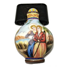
EXQUISITE CHINESE SNUFF BOTTLE ENAMEL ON COPPER PEOPLE QIANLONG MARKNoble House Collection Gallery4.5(114)See Sold PriceFeb 28, 2024
FINE CHINESE ENAMEL ON COPPER SNUFF BOTTLE BIRDS PEONIES QIANLONG MARKNoble House Collection Gallery4.5(114)See Sold PriceFeb 28, 2024
FINE CHINESE ENAMEL COPPER SNUFF BOTTLE GENERAL ZHAN FEI QIANLONG MARKNoble House Collection Gallery4.5(114)See Sold PriceFeb 28, 2024
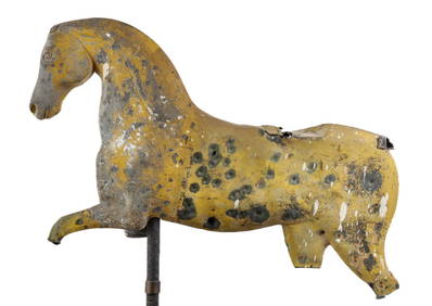
(19th c) RUNNING HORSE WEATHERVANE FRAGMENTJohn McInnis Auctioneers,LLC4.6(502)See Sold PriceFeb 25, 2024
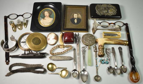
56 Pieces of hardstone signets/seals, approximate numbers (4) tortoise shell cameos, (3) carved hardNeely Auction4.6(224)See Sold PriceFeb 25, 2024
SUPERB CHINESE ENAMEL SNUFF BOTTLE WITH SNUFF DISH LANDSCAPE QIANLONG MARKNoble House Collection Gallery4.5(114)See Sold PriceFeb 28, 2024
FINE CHINESE ENAMEL ON COPPER SNUFF BOTTLE CHILDREN IMMORTALS QIANLONG MARKNoble House Collection Gallery4.5(114)See Sold PriceFeb 28, 2024
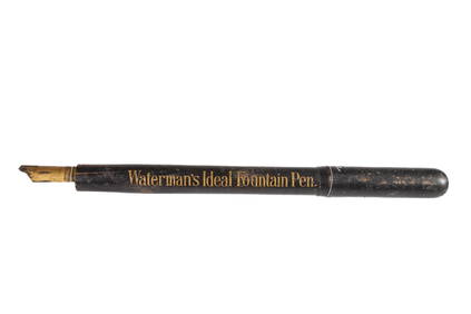
WATERMAN'S IDEAL FOUNTAIN PEN RETAILERS SIGNJohn McInnis Auctioneers,LLC4.6(502)See Sold PriceFeb 25, 2024
Missouri Territory, formerly LouisianaMatthew Carey. Philadelphia, 1814. Copperplate engraving with original outline hand color. Sheet size: 17 x 22 inches. For most of the 18th century, the business of colonial map publishing was dominatSee Sold Price
1825 Carte du Territoire D’Arkansa.This copper plate engraving is a French edition of Stephen Long’s seminal map of the region drained by the Arkansas, Kansas, Missouri and Mississippi Rivers, one of the most important maps of tSee Sold Price
Guillaume Delisle (1675-1726)The First Map to Name Texas and to show the Missouri River Carte de la Louisiane et du Cours du Mississippi 1st edition, 1718 Copper-plate engraving with original hand color: 201/2" x 271/4" ReferenceSee Sold Price
SoldJ. Wilkes copper plate engraving - map of ItalyCirca 1807. map size 11"h x 8.5"w Framed 20"h x 16"w .See Sold Price
SoldCopper Plate Engravings, Maps, Approx. 30, VariousCopper Plate Engravings, Maps, Approx. 30, Various States and Countries, as Removed from Mitchell's Modern Atlas 1880, $50-$100.See Sold Price
SoldMap of the Americas-1746.Map of North and South America by Homann Heirs titled "Americae Mappa generalis" with a decorative cartouche. Nuremberg 1746. Light coloring on original copper plate engraving. Map measures 19" x 22"See Sold Price
Antoine Augustin Calmet - Acre, 1732.Antoine Augustin Calmet - Prospect of the Town and Harbour of Ptolemais in Phaenicia (Acre), 1732. Copper plate engraving map. 30cm X 43cm / 11.8in X 16.9in.See Sold Price
Sold1600s MapMap, ca 1600s, entitled: Surrey Described and Divided Into Hundreds. Copper plate engraving map printed on pulp paper, once part of a complete volume. Consists of two pages bound together as framableSee Sold Price
SoldAntoine Augustin Calmet - Prospect of the Town andAntoine Augustin Calmet - Prospect of the Town and Harbour of Ptolemais in Phaenicia (Acre), 1732. Copper plate engraving map. 30cm X 43cm / 11.8in X 16.9in. stains, hole. See Sold Price
John C. Russell, 1745-1806, artist engraver CJohn C. Russell, 1745-1806, artist engraver Ca. 1790, Hand colored copper plate engraving map of Canaan-Judea. Recent new museum mounting and framing. Estimated more than 200 yrs old. (Pangaea AuctionSee Sold Price
SoldLate 17th Century Map of GreeceCopper plate engraving map of Greece titled "Graeciae Antiquae Tabula Geographica" by Nicolas Sanson (1600-1667) and engraved in Padua, Italy in 1694 by F.Bertin and produced under the auspices of theSee Sold Price
SoldMap. LIDALIA vel Lidisdalia Regio Lidisdail. CoppMap. LIDALIA vel Lidisdalia Regio Lidisdail. Copper plate engraving. Map: northern England & parts of Scotland. -- Dimensions: H: 15.5 inches: W: 20 inches ---See Sold Price
SoldJ. Thomson & Co.J. Thomson & Co., A New General Atlas, Edinburgh, UK 1817 with 74 hand colored maps some with original boards, features double-page and/or folding hand-colored copper-plate engraving maps, printed bySee Sold Price
SoldRamusio, Giovanni Battista & Gastaldi, Giacomo - TerzaArtist: Ramusio, Giovanni Battista & Gastaldi, Giacomo Title: Terza Ostro Tavola (The Ramusio-Gastaldi Map of 1563) Medium: copperplate engraving map is hexagonal measuring 38 cm at the top, 39.2 cm aSee Sold Price
SoldHistorical map of the ArchbishopricHistorical map of the Archbishopric of Trier ''Mosellae Fluminis Tabula Specialis in qua Archiepiscopatus et Electoratus Trevirensis'', partly colored copperplate engraving, map of the Archbishopric oSee Sold Price
1832 Antique Map of the Western Hemisphere19th century. A large copperplate engraving map of the western hemisphere dating to 1832. Overall good condition. Some creasing and toning; beginning to split at center. Print at bottom cut so publiSee Sold Price
SoldMap of the Americas 1614 Copper Plate Engraving 17C MapCopper Plate Engraved 17C Map of The Americas. The 17th century antique map title is "Americae Nova Descriptio" and dated 1614. A copperplate engraving by Abraham Goos with hand coloring. The 17th cenSee Sold Price
Japaniae Nova Description by Jan Jansson 1636Map Title: Japaniae Nova Description Artist: Jan Jansson Publisher: J. Jansson, Amsterdam Date: 1636 Size: 13.5 x 17.5 inches Medium: Hand colored copper plate engraving This map is virtually identicaSee Sold Price
SoldFramed large antique map of China, Japan and KoreFramed large antique map of China, Japan and Korea. Hand-colored copper-plate engraving. Dutch map. Circa 17th C, possibly earlier by Jodocus Hondius, from Hondius' Gerardi Mercatoris Atlas, publishedSee Sold Price
[WESTERN MAP] Johnson's 1858 Pocket Map of Missour[WESTERN MAP] Johnson's 1858 Pocket Map of Missouri and Kansas Johnson's New Rail-Road & Township Copper Plate Map of Missouri and Kansas, New York: A.J. Johnson and Chicago: Rufus Blanchard. 19.75See Sold Price
Map of Virginia to Florida from circa 1590-1591Copperplate engraving. This map accompanies the first edition of Gerard Mercator's atlas by Jodocus Hondius, and is the only regional one of North America present. It is a composite largely of John WhSee Sold Price
Sold1610 H/C Engraved Map of Worcestershire, SaxtonBeautiful 1610 Hand-colored Copperplate Engraving of Map of Worcestershire by Cartographer Christopher Saxton Entitled Wigorniensis Comitatus Sabrinae | Engraved map by William Hole | From Camden's BrSee Sold Price
17TH C. WORLD MAP BY NICOLAES VISSCHER (NETHERLANDS, 1618-1709)Thomaston Place Auction Galleries4.4(386)See Sold PriceFeb 24, 2024
LATE 17TH C. FRENCH MAP OF THE NEW WORLD BY ALEXIS-HUBERT JAILLOT (1632-1712)Thomaston Place Auction Galleries4.4(386)See Sold PriceFeb 24, 2024
RARE 1638 HONDIUS MAP OF BERMUDA, FRAMEDThomaston Place Auction Galleries4.4(386)See Sold PriceFeb 24, 2024
COVENS & MORTIER 1745 MAP OF THE GLOBEThomaston Place Auction Galleries4.4(386)See Sold PriceFeb 24, 2024
LATE 16TH C. MAP OF SCOTLAND BY MERCATOR, FRAMEDThomaston Place Auction Galleries4.4(386)See Sold PriceFeb 24, 2024
17TH C. MAP OF THE BERKSHIRES BY JOHN SPEED, FRAMEDThomaston Place Auction Galleries4.4(386)See Sold PriceFeb 24, 2024
18TH C. ANTIQUE MAP: FRENCH & INDIAN WAR, FRAMEDThomaston Place Auction Galleries4.4(386)See Sold PriceFeb 24, 2024
17TH C. ENGLISH LINEAR MAP BY OGILBY, FRAMEDThomaston Place Auction Galleries4.4(386)See Sold PriceFeb 24, 2024
ABRAHAM ORTELIUS (1527-1598) MAP OF ROMAN GAUL (FRANCE)Thomaston Place Auction Galleries4.4(386)See Sold PriceFeb 24, 2024
NICOLAES VISSCHER (NETHERLANDS, 1618-1709) MAP OF THE NEW WORLDThomaston Place Auction Galleries4.4(386)See Sold PriceFeb 24, 2024
WILLEM JANSZOON BLAEU (NETHERLANDS, 1571-1638) MAP OF UMBRIAThomaston Place Auction Galleries4.4(386)See Sold PriceFeb 24, 2024
PAUL SANDBY Copperplate Mezzotint Landscape 1738 Framed & SuperbLuis Porretta Fine Arts4.3(10)See Sold PriceMar 02, 2024
Raphael - Religious Fresco or Decorative Pilaster. 3Trillium Antique Prints & Rare Books4.5(30)See Sold PriceFeb 24, 2024
Raphael - Religious Fresco or Decorative Pilaster. 7Trillium Antique Prints & Rare Books4.5(30)See Sold PriceFeb 24, 2024
Hubert Kornelisz (1689 - 1733) - Set of 2 Allegorical Copperplate Engravings, NetherlandsProverde Auctions4.3(3)See Sold PriceFeb 28, 2024
Hubert Kornelisz (1689 - 1733) - Set of 2 Allegorical Copperplate Engravings, NetherlandsProverde Auctions4.3(3)See Sold PriceFeb 28, 2024
Pieter Mortier (1661-1711) - Set of 2 Biblical Engravings - "Death of Herod Agrippa" - "PaulProverde Auctions4.3(3)See Sold PriceFeb 28, 2024
Pieter Mortier (1661-1711) - Set of 2 Biblical Engravings - "The apostles Paulus and Barnabas in theProverde Auctions4.3(3)See Sold PriceFeb 28, 2024
Robert Benard (1734 - 1777) - Set of 9 Copperplate Engravings - Greek and Roman architecture - ViewProverde Auctions4.3(3)See Sold PriceFeb 28, 2024
Robert Benard (1734 - 1777) - Set of 9 Copperplate Engravings - Architecture, Masonry, Quarry withProverde Auctions4.3(3)See Sold PriceFeb 28, 2024


![[WESTERN MAP] Johnson's 1858 Pocket Map of Missour (1 of 1)](https://p1.liveauctioneers.com/46/23326/8239685_1_x.jpg?height=282&quality=70)


