ATLAS of ANTIENT GEOGRAPHY by SAMUEL BUTLER 1843John McInnis Auctioneers,LLC4.5(505)See Sold PriceFeb 24, 2024
18TH C. ANTIQUE MAP: FRENCH & INDIAN WAR, FRAMEDThomaston Place Auction Galleries4.4(393)See Sold PriceFeb 24, 2024
Rand McNally Railroad Map Cabinet w/ 21 Railroad MapsRail & Road Auctions4.6(165)See Sold PriceMar 08, 2024
Keith Haring - Ink on New York Map, Best Buddies, Inscribed, Signed, and DatedSapphire Auction Gallery4(67)See Sold PriceMar 02, 2024
LATE 17TH C. FRENCH MAP OF THE NEW WORLD BY ALEXIS-HUBERT JAILLOT (1632-1712)Thomaston Place Auction Galleries4.4(393)See Sold PriceFeb 24, 2024
Central Railroad of New Jersey Map of Sandy Hook Route-ca. 1903JM Hobby Supply and Railroad Artifact Auctions4.4(127)See Sold PriceFeb 24, 2024
Lot of Six Mixed Atlas Box Cars-HO Scale-New in BoxJM Hobby Supply and Railroad Artifact Auctions4.4(127)See Sold PriceFeb 25, 2024
Rand McNally/Santa Fe Railroad Map of Iowa-1912JM Hobby Supply and Railroad Artifact Auctions4.4(127)See Sold PriceFeb 24, 2024
NICOLAES VISSCHER (NETHERLANDS, 1618-1709) MAP OF THE NEW WORLDThomaston Place Auction Galleries4.4(393)See Sold PriceFeb 24, 2024
17TH C. WORLD MAP BY NICOLAES VISSCHER (NETHERLANDS, 1618-1709)Thomaston Place Auction Galleries4.4(393)See Sold PriceFeb 24, 2024
Lot of Six Mixed Atlas Cabooses-HO Scale-New in BoxJM Hobby Supply and Railroad Artifact Auctions4.4(127)See Sold PriceFeb 25, 2024
COPERNICUS HELIOCENTRIC MODEL. Movement of the planets. MALLET 1683 old mapTITLE OF MAP (NOT PRINTED ON THE PAGE):[Raisons de Copernic touchant le second mouvement de la Terre, qui est son mouvement annuel sous l'Ecliptique] (De la Sphere) DATE PRINTED: 1683 IMAGE SIZE: ApprSee Sold Price
COPERNICUS HELIOCENTRIC MODEL. Movement of the planets.TITLE OF MAP (NOT PRINTED ON THE PAGE):'[Raisons de Copernic touchant le second mouvement de la Terre, qui est son mouvement annuel sous l'Ecliptique]' DATE PRINTED: 1683 IMAGE SIZE: Approx Overall paSee Sold Price
COPERNICUS HELIOCENTRIC UNIVERSE. Planets rotate around Sun. MALLET 1683 mapTITLE OF THE MAP: 'Systeme de l'Univers selon Copernic' (De la Sphere) DATE PRINTED: 1683 IMAGE SIZE: Approx Overall page size 13 x 21cm approximately (5 x 8 inches); image size 10.5 x 14.5cm approximSee Sold Price
SoldCOPERNICUS HELIOCENTRIC MODEL. Movement of the planets.TITLE OF MAP (NOT PRINTED ON THE PAGE):'[Raisons de Copernic touchant le second mouvement de la Terre, qui est son mouvement annuel sous l'Ecliptique]' The top image on the right hand side shows the eSee Sold Price
HELIOCENTRIC SOLAR SYSTEM. Earth's movement as per Copernicus. MALLET 1683 mapTITLE OF MAP (NOT PRINTED ON THE PAGE):[Raisons de Copernic touchant le troisiéme mouvement de la Terre] (De la Sphere) Illustrates the changing seasons according to the angle of the earth's axisSee Sold Price
ASTRONOMY. Des Aspects des Planettes. Planets. MALLET 1683 old antique printTITLE OF PRINT (NOT PRINTED ON THE PAGE):[Des Aspects des Planettes] (De la Sphere) DATE PRINTED: 1683 IMAGE SIZE: Approx Overall page size 13 x 21cm approximately (5 x 8 inches); image size 10.5 x 14See Sold Price
SOLAR SYSTEM. Copernicus Heliocentric universe. Landscape view. MALLET 1683TITLE OF PRINT (NOT PRINTED ON THE PAGE):[Raisons de Copernic sur le premier mouvemen de la Terre] (De la Sphere) DATE PRINTED: 1683 IMAGE SIZE: Approx Overall page size 13 x 21cm approximately (5 x 8See Sold Price
HEAVENS & EARTH. 5 zones according to Thales & Pythagoras. MALLET 1683 old mapTITLE OF MAP (NOT PRINTED ON THE PAGE):[Covenance des Zones du Ciel & de la Terre] (De la Sphere) Shows Australia with a very inaccurate (and incomplete) shape. Partial outline of Terra Australis, theSee Sold Price
MEDITERRANEAN. 'Mer Mediterranee Selon Les Anciens. MALLET 1683 old mapTITLE OF THE MAP: 'Mer Mediterranee Selon Les Anciens; Partie Orientale de la mer Mediterranee; Partie Occidentale de la Mer Mediterranee' (Du Globe Terrestre) DATE PRINTED: 1683 IMAGE SIZE: Approx OvSee Sold Price
BALKANS. Pannonie/Pannonia Illyria. Croatia Bosnia Serbia. MALLET 1683 old mapTITLE OF THE MAP: 'Pannonie et Illyrie' (De L'Europe) Pannonia was an ancient province of the Roman Empire bounded north and east by the Danube, coterminous westward with Noricum and upper Italy, andSee Sold Price
EAST INDIES. Sunda Sumatra Java Borneo Malaya. Indonesia. MALLET 1683 old mapTITLE OF THE MAP: 'Isles de la Sonde vers l'Occident' (De L'Asie) Shows the western Sunda Islands, the Malay peninsula and the southern part of Indochina (from Cambodia to Singapore). It includes JavaSee Sold Price
PARIS. Town city plan. 'Plan de Paris'. Decorative. MALLET 1683 old mapTITLE OF THE MAP: 'Plan de Paris' (De L'Europe) DATE PRINTED: 1683 IMAGE SIZE: Approx Overall page size 13 x 21cm approximately (5 x 8 inches); image size 10.5 x 14.5cm approximately (4 x 5.5 inches)See Sold Price
HEAVENS & EARTH. 5 zones according to Thales & Pythagoras. MALLET 1683 old mapTITLE OF MAP (NOT PRINTED ON THE PAGE):[Covenance des Zones du Ciel & de la Terre] (De la Sphere) Shows Australia with a very inaccurate (and incomplete) shape. Partial outline of Terra Australis, theSee Sold Price
BALKANS. Pannonie/Pannonia Illyria. Croatia Bosnia Serbia. MALLET 1683 old mapTITLE OF THE MAP: 'Pannonie et Illyrie' (De L'Europe) Pannonia was an ancient province of the Roman Empire bounded north and east by the Danube, coterminous westward with Noricum and upper Italy, andSee Sold Price
EASTERN HEMISPHERE. Shows incomplete Australian coastline. MALLET 1683 old mapTITLE OF THE MAP: 'Ancien Continent' (Du Globe Terrestre) Partial outline of Terra Australis, the hypothesised southern continent, is shown. DATE PRINTED: 1683 IMAGE SIZE: Approx Overall page size 13See Sold Price
ANCIENT EUROPE. Rivers. Latin/Roman names. Decorative. MALLET 1683 old mapTITLE OF THE MAP: 'Europe Ancienne' (De L'Europe) DATE PRINTED: 1683 IMAGE SIZE: Approx Overall page size 13 x 21cm approximately (5 x 8 inches); image size 10.5 x 14.5cm approximately (4 x 5.5 inchesSee Sold Price
CAUCASUS. 'Georgie Armenie' Georgia Armenia Tblisi Russia. MALLET 1683 old mapTITLE OF THE MAP: 'Georgie Armenie' (De L'Asie) DATE PRINTED: 1683 IMAGE SIZE: Approx Overall page size 13 x 21cm approximately (5 x 8 inches); image size 10.5 x 14.5cm approximately (4 x 5.5 inches)See Sold Price
BALKANS. Pannonie/Pannonia Illyria. Croatia Bosnia Serbia. MALLET 1683 old mapTITLE OF THE MAP: 'Pannonie et Illyrie' (De L'Europe) Pannonia was an ancient province of the Roman Empire bounded north and east by the Danube, coterminous westward with Noricum and upper Italy, andSee Sold Price
MEDITERRANEAN. 'Mer Mediterranee Selon Les Modernes. MALLET 1683 old mapTITLE OF THE MAP: 'Mer Mediterranee Selon Les Modernes; Partie Orientale de la mer Mediterranee; Partie Occidentale de la Mer Mediterranee' (Du Globe Terrestre) DATE PRINTED: 1683 IMAGE SIZE: Approx OSee Sold Price
CAUCASUS. 'Georgie Armenie' Georgia Armenia Tblisi Russia. MALLET 1683 old mapTITLE OF THE MAP: 'Georgie Armenie' (De L'Asie) DATE PRINTED: 1683 IMAGE SIZE: Approx Overall page size 13 x 21cm approximately (5 x 8 inches); image size 10.5 x 14.5cm approximately (4 x 5.5 inches)See Sold Price
MEDITERRANEAN. 'Mer Mediterranee Selon Les Modernes. MALLET 1683 old mapTITLE OF THE MAP: 'Mer Mediterranee Selon Les Modernes; Partie Orientale de la mer Mediterranee; Partie Occidentale de la Mer Mediterranee' (Du Globe Terrestre) DATE PRINTED: 1683 IMAGE SIZE: Approx OSee Sold Price
MALTA GOZO COMINO. 'Isle de Malthe'. Decorative vignette. MALLET 1683 old mapTITLE OF THE MAP: 'Isle de Malthe' (De L'Afrique) DATE PRINTED: 1683 IMAGE SIZE: Approx Overall page size 13 x 21cm approximately (5 x 8 inches); image size 10.5 x 14.5cm approximately (4 x 5.5 inchesSee Sold Price
WEST CENTRAL AFRICA. Congo Angola Gabon Cameroon Sao Tome. MALLET 1683 old mapTITLE OF THE MAP: 'Congo' (De L'Afrique) The map shows the western coast of Central Africa, including the modern countries of Gabon Cameroon Congo & Angola. DATE PRINTED: 1683 IMAGE SIZE: Approx OveraSee Sold Price
CORSICA. 'Isle de Corse'. Elba. Decorative. France. MALLET 1683 old mapTITLE OF THE MAP: 'I(sle) de Corse' (De L'Europe) DATE PRINTED: 1683 IMAGE SIZE: Approx Overall page size 13 x 21cm approximately (5 x 8 inches); image size 10.5 x 14.5cm approximately (4 x 5.5 inchesSee Sold Price
Nova Totius Full Color Geographical World MapThe Benefit Shop Foundation Inc.4.3(2.9k)See Sold PriceFeb 28, 2024
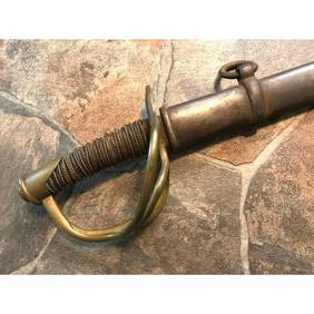
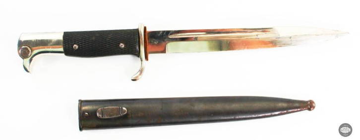
Model 1840 Sheble Fisher US Cavalry Saber SwordConnoisseur Auctions3.9(336)See Sold PriceMar 02, 2024
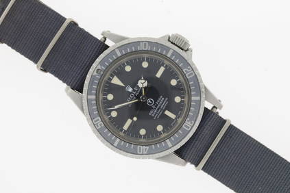
OMEGA Speedmaster Snoopy Award 50th Anniversary Model 310.32.42.50.02.001 Silver/Blue Dial WatchBidhaus4.3(762)See Sold PriceFeb 27, 2024
Willem Blaeu, Etc. 17th C. Antiquarian Maps, 2Auctions at Showplace4.6(740)See Sold PriceMar 17, 2024
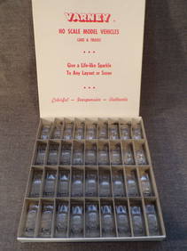
Lot of 36 Vintage 1950's Varney HO Scale Model Vehicles in Box.Westside Traders Emporium4.5(34)See Sold PriceFeb 27, 2024
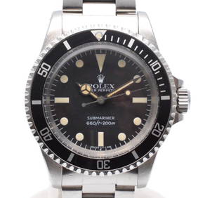
Brand: Rare Rolex Model Name: Submariner 'Milsub' Reference: 5513 Movement: Automatic Year: CircaSterling Vault Auctioneers4.3(12)See Sold PriceFeb 29, 2024
Brand: Rare Rolex Model Name: Sea Dweller 'Double Red' Reference: 1665 Complication: Date Movement:Sterling Vault Auctioneers4.3(12)See Sold PriceFeb 29, 2024
L. & J.G. Stickley, Paddle-arm Morris chairToomey & Co. Auctioneers4.7(392)See Sold PriceFeb 29, 2024
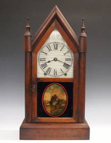
Thomas Harland Sligh inlaid Grandfather ClockBroken Arch Auction Gallery NCFL#93994.6(300)See Sold PriceMar 04, 2024
WEST CENTRAL AFRICA. Congo Angola Gabon Cameroon Sao Tome. MALLET 1683 old mapJasper524.5(9.9k)See Sold PriceFeb 28, 2024
NUBIA. 'Nubie'. Nile Valley. Sudan Ethiopia Egypt. MALLET 1683 old antique mapJasper524.5(9.9k)See Sold PriceFeb 28, 2024
SUB-SAHARAN AFRICA. 'Ancienne Ethiopie'. Ancient Ethiopia. MALLET 1683 old mapJasper524.5(9.9k)See Sold PriceFeb 28, 2024
WWII Era German Firefighter's Parade BayonetOld Steel Historical Firearms LLC4.3(44)See Sold PriceJul 09, 2024