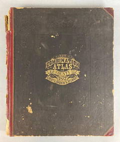
SoldCombination Atlas Map of Summit County, 1874Heading: (Ohio) Author: Title: Combination Atlas Map of Summit County Place Published: Philadelphia Publisher:Tackabury, Mead, & Moffett Date Published: 1874 Description: 1See Sold Price
Combination Atlas Map of Summit County, 1874Heading: (Ohio) Author: Title: Combination Atlas Map of Summit County Place Published: Philadelphia Publisher:Tackabury, Mead, & Moffett Date Published: 1874 Description: 1See Sold Price
SoldLithographs 1874 from Combination Atlas Map SummitLithographs 1874 from Combination Atlas Map Summit County: A great group of lithograph pages from 1874. Included in this lot are Maplewood Fam, Office Mills and Lumber Yard of Miller and Thomas, AcadeSee Sold Price
Sold(2) Hand Colored Engravings of Residences in Summit(2) Hand Colored Engravings of Residences in Summit County Ohio 1874: Matted and framed measuring 22 x 26, these are 2 engravings from the Combination Atlas Map of Summit County by Tackabury, Mead, anSee Sold Price
Sold1874 Atlas Map of Summit County Stone Lithographs1874 Atlas Map of Summit County Stone Lithographs: A beautiful set of stone lithographs from the Atlas Map of Summit County Ohio 1874. Residences include: Frank Adams, L. King, L. Leach, C.A. Viers, WSee Sold Price
1874 Atlas Map of Summit County Stone Lithographs1874 Atlas Map of Summit County Stone Lithographs: A beautiful set of stone lithographs from the Atlas Map of Summit County Ohio 1874. Residences include: Frank Adams, L. King, L. Leach, C.A. Viers, WSee Sold Price
1874 Atlas Map of Summit County Stone Lithographs1874 Atlas Map of Summit County Stone Lithographs: A beautiful set of stone lithographs from the Atlas Map of Summit County Ohio 1874. Residences include: Frank Adams, L. King, L. Leach, C.A. Viers, WSee Sold Price
1874 Atlas Map of Summit County Stone Lithographs1874 Atlas Map of Summit County Stone Lithographs: A beautiful set of stone lithographs from the Atlas Map of Summit County Ohio 1874. Residences include: Frank Adams, L. King, L. Leach, C.A. Viers, WSee Sold Price
SoldAntique Folio Atlas COMBINATION ATLAS MAP OF SANDUSKYAntique Folio Atlas COMBINATION ATLAS MAP OF SANDUSKY COUNTY OHIO 1874 Elephant Folio Color Maps Fold-Outs Portraits Sketches Lithographic Views Everts Stewart and Co Fremont Rice Riley Jackson ScottSee Sold Price
SoldCombination Atlas Map of Medina County Ohio''Combination Atlas Map of Medina County Ohio'', L. H. Everts, Chicago, 1874, all 106 pp present, 14 3/4'' x 17 1/2''h, hard bound in black and green cloth cover with embossed and gilt lettering, someSee Sold Price
SoldCombination Atlas Map of Medina County Ohio''Combination Atlas Map of Medina County Ohio'', L. H. Everts, Chicago, 1874, all 106 pp present, 14 3/4'' x 17 1/2''h, hard bound in black and green cloth cover with embossed and gilt lettering, someSee Sold Price
SoldCombination Atlas Map of Portage County Ohio''Combination Atlas Map of Portage County, Ohio'', L. H. Everts, Chicago, 1874, 148 pp, plus additional 21 pgs, 14 1/4 x 17 1/4''h, hard bound in dark blue green textured cloth and three-quarter leathSee Sold Price
Combination Atlas Map of DuPage County, IllinoisTitle: Combination Atlas Map of DuPage County, Illinois. Elgin. Thompson Bro's & Burr. [1874] 1974 Author(s): (anon). Facsimile edition Condition: Fine copy. 4to. Gilt decorated hard cover. . IllustraSee Sold Price
Sold2 Atlas - Ashland and Medina counties, Ohio2 Atlas- 1.) ''Caldwell's Atlas of Ashland County, Ohio'', J. A. Caldwell, Condit, Ohio, 1874; 2.) ''Combination Atlas Map of Medina County, Ohio'', L. H. Everts, Chicago, Illinois, 1874- both hardbouSee Sold Price
SoldPair of Combination Atlas Maps of Washtenaw and Jackson[Michigan] Pair of Combination Atlas Maps of Washtenaw and Jackson Counties, Michigan. Chicago: Everts & Stewart, 1874. Jackson County atlas re-backed in cloth with original pebbled boards and leatherSee Sold Price
SoldCombination Atlas of Butler Co. & Pennsylvania''Combination Atlas of the County of Butler and The State of Pennsylvania'', G. M. Hopkins & Co., Philadelphia, 1874, title plus 90 pp total, with 32 maps including 3 triple-page fold out maps, largeSee Sold Price
SoldCOMBINATION ATLAS MAP OF OGLE COUNTY, ILL.Chicago 1872, Township maps and many litho views of farms, etc. (maps colored, reverses are blank).See Sold Price
1875 Historical Combination Atlas Map of Stark County Ohio1875 Combination Atlas Map of Stark County, Ohio. Original 1/2 leather, boards detached, corners largely perished. Good internally, with light soiling, some short tears. In spite of the condition, thiSee Sold Price
Combination Atlas Map of Montgomery County Ohio''Combination Atlas Map of Montgomery County Ohio'', L. H. Everts, 1875, 176 pp, including pages 29 1/4, 29 1/2, 36 1/4 and 36 1/2, 14 1/2''w. x 17 1/4''h, hard bound in dark green textured cloth andSee Sold Price
SoldCombination Atlas Map of Montgomery County Ohio''Combination Atlas Map of Montgomery County Ohio'', L. H. Everts, 1875, 176 pp, including pages 29 1/4, 29 1/2, 36 1/4 and 36 1/2, 14 1/2''w. x 17 1/4''h, hard bound in dark green textured cloth andSee Sold Price
Combination Atlas Map of DuPage County, Illinois.Combination Atlas Map of DuPage County, Illinois. (anon). Thompson Bro's & Burr. Facsimile edition. 4to. Illustrated. Important reference work. Related material laid in. Shipping: Domestic: Flat-rateSee Sold Price
Combination Atlas Map of DuPage County, Illinois.Combination Atlas Map of DuPage County, Illinois. (anon). Thompson Bro's & Burr. Facsimile edition. 4to. Illustrated. Important reference work. Related material laid in. Shipping: Domestic: Flat-rateSee Sold Price
Combination Atlas Map of DuPage County, IllinoisCombination Atlas Map of DuPage County, Illinois.. (anon).. Thompson Bro's & Burr.. Facsimile edition.. Illustrated. Important reference work. Related material laid in. Please note that this lot has aSee Sold Price
SoldAntique Folio Atlas COMBINATION ATLAS MAP OF WALWORTHAntique Folio Atlas COMBINATION ATLAS MAP OF WALWORTH COUNTY WISCONSIN 1873 Elephant Folio Color Maps Fold-Outs Lithographic Views Everts Baskin and Stewart Geneva Lake Townships Bloomfield Lyons GeneSee Sold Price
DUNLEVIE c1856 Map Counties Of Gaspe & Bonaventure Quebec Canada SCARCE! #2Luis Porretta Fine Arts4.3(10)See Sold PriceMar 02, 2024
DUNLEVIE c1856 Map Counties Of Gaspe & Bonaventure Quebec Canada SCARCE! #1Luis Porretta Fine Arts4.3(10)See Sold PriceMar 02, 2024
General Books - Nicolson - The Counties of Britain - A Tudor Atlas by John SpeedTimeLine Auctions Ltd.4.6(183)See Sold PriceMar 08, 2024
Vintage County Map Of NY State Plate EngravingThe Benefit Shop Foundation Inc.4.3(2.9k)See Sold PriceFeb 28, 2024
Portfolio of 15 County Maps by Robert Morden (English 1650-1703)Nadeau's Auction Gallery4.7(409)See Sold PriceFeb 24, 2024
1849 Mitchell School ATLAS 24 MAPS America Holy Land France Africa Egypt AsiaSchilb Antiquarian Rare Books4.8(428)See Sold PriceMar 31, 2024
Pair of Early Railroad Maps - 1874 Delaware, Lackawanna & Western and 1876 Pennsylvania RailroadRail & Road Auctions4.6(165)See Sold PriceMar 07, 2024
Rand McNally & Co's New Ideal State and County Survey and Atlas 1911North American Artifact Auctions4.7(198)See Sold PriceApr 20, 2024
1872 New Combination Atlas of Lee County Illinois BookMatthew Bullock Auctioneers4.7(1.8k)See Sold PriceFeb 24, 2024
1905 20th Century Atlas of Boone County IllinoisMatthew Bullock Auctioneers4.7(1.8k)See Sold PriceFeb 24, 2024
1868 Handwritten diary of Ohio canal boat operator & farmerJasper524.5(9.9k)See Sold PriceFeb 27, 2024
COLONIAL AFRICA Afrique. League of Nations Mandates. Ethnicity 1938 old mapJasper524.5(9.9k)See Sold PriceFeb 28, 2024
SOUTHERN AFRICA. Congo British/Portuguese/German East Africa Rhodesia 1912 mapJasper524.5(9.9k)See Sold PriceFeb 28, 2024