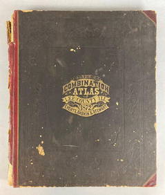
SoldCombination Atlas Map of Medina County Ohio''Combination Atlas Map of Medina County Ohio'', L. H. Everts, Chicago, 1874, all 106 pp present, 14 3/4'' x 17 1/2''h, hard bound in black and green cloth cover with embossed and gilt lettering, someSee Sold Price
SoldCombination Atlas Map of Medina County Ohio''Combination Atlas Map of Medina County Ohio'', L. H. Everts, Chicago, 1874, all 106 pp present, 14 3/4'' x 17 1/2''h, hard bound in black and green cloth cover with embossed and gilt lettering, someSee Sold Price
Sold2 Atlas - Ashland and Medina counties, Ohio2 Atlas- 1.) ''Caldwell's Atlas of Ashland County, Ohio'', J. A. Caldwell, Condit, Ohio, 1874; 2.) ''Combination Atlas Map of Medina County, Ohio'', L. H. Everts, Chicago, Illinois, 1874- both hardbouSee Sold Price
1875 Historical Combination Atlas Map of Stark County Ohio1875 Combination Atlas Map of Stark County, Ohio. Original 1/2 leather, boards detached, corners largely perished. Good internally, with light soiling, some short tears. In spite of the condition, thiSee Sold Price
Combination Atlas Map of Montgomery County Ohio''Combination Atlas Map of Montgomery County Ohio'', L. H. Everts, 1875, 176 pp, including pages 29 1/4, 29 1/2, 36 1/4 and 36 1/2, 14 1/2''w. x 17 1/4''h, hard bound in dark green textured cloth andSee Sold Price
SoldCombination Atlas Map of Montgomery County Ohio''Combination Atlas Map of Montgomery County Ohio'', L. H. Everts, 1875, 176 pp, including pages 29 1/4, 29 1/2, 36 1/4 and 36 1/2, 14 1/2''w. x 17 1/4''h, hard bound in dark green textured cloth andSee Sold Price
SoldCombination Atlas Map of Portage County Ohio''Combination Atlas Map of Portage County, Ohio'', L. H. Everts, Chicago, 1874, 148 pp, plus additional 21 pgs, 14 1/4 x 17 1/4''h, hard bound in dark blue green textured cloth and three-quarter leathSee Sold Price
SoldAntique Folio Atlas COMBINATION ATLAS MAP OF SANDUSKYAntique Folio Atlas COMBINATION ATLAS MAP OF SANDUSKY COUNTY OHIO 1874 Elephant Folio Color Maps Fold-Outs Portraits Sketches Lithographic Views Everts Stewart and Co Fremont Rice Riley Jackson ScottSee Sold Price
SoldHistorical Atlas of Licking County, Ohio, 1875, Historical Atlas of Licking County, Ohio, 1875, Everts, L.H. Combination Atlas Map of Licking County, Ohio. 1875. Printed by Thos. Hunter, Phila. 37 hand-colored maps, several double-page.See Sold Price
SoldAtlas of Stark County Ohio Combination Atlas Map 1875Atlas of Stark County Ohio Combination Atlas Map 1875: A nice book from 1875. An oversize atlas map of Stark County. By L.H. Everts and Co. There is some water marks on some pages but all of the mapsSee Sold Price
Sold(2) Hand Colored Engravings of Residences in Summit(2) Hand Colored Engravings of Residences in Summit County Ohio 1874: Matted and framed measuring 22 x 26, these are 2 engravings from the Combination Atlas Map of Summit County by Tackabury, Mead, anSee Sold Price
SoldCombination Atlas Map of Summit County, 1874Heading: (Ohio) Author: Title: Combination Atlas Map of Summit County Place Published: Philadelphia Publisher:Tackabury, Mead, & Moffett Date Published: 1874 Description: 1See Sold Price
Sold(OHIO.) Levers, L. H. Combination Atlas Map of(OHIO.) Levers, L. H. Combination Atlas Map of Portage County. Numerous hand-colored maps, lithographed views. Folio, library buckram; ex-library, with small inked stamp on title, otherwise unmarked.See Sold Price
Combination Atlas Map of Summit County, 1874Heading: (Ohio) Author: Title: Combination Atlas Map of Summit County Place Published: Philadelphia Publisher:Tackabury, Mead, & Moffett Date Published: 1874 Description: 1See Sold Price
Untitled. [Two Real Estate Plats of Portions of WoodMap: Untitled. [Two Real Estate Plats of Portions of Wood County, Ohio] Date: 1880 Cartographer: ANONYMOUS Size (inches): 12.6x12.25 Traced or transcribed from the Combination atlas of Sandusky, OhioSee Sold Price
SoldLithographs 1874 from Combination Atlas Map SummitLithographs 1874 from Combination Atlas Map Summit County: A great group of lithograph pages from 1874. Included in this lot are Maplewood Fam, Office Mills and Lumber Yard of Miller and Thomas, AcadeSee Sold Price
A Collection of Books and Atlases of Medina County,A Collection of Books and Atlases of Medina County, Ohio, 19th/20th Century. Largest dimensions: h: 19 x w: 15 in. Other Notes: *** Please inquire for shipping estimate prior to bidding. Shipping costSee Sold Price
SoldCOMBINATION ATLAS MAP OF OGLE COUNTY, ILL.Chicago 1872, Township maps and many litho views of farms, etc. (maps colored, reverses are blank).See Sold Price
Combination Atlas Map of DuPage County, Illinois.Combination Atlas Map of DuPage County, Illinois. (anon). Thompson Bro's & Burr. Facsimile edition. 4to. Illustrated. Important reference work. Related material laid in. Shipping: Domestic: Flat-rateSee Sold Price
Combination Atlas Map of DuPage County, Illinois.Combination Atlas Map of DuPage County, Illinois. (anon). Thompson Bro's & Burr. Facsimile edition. 4to. Illustrated. Important reference work. Related material laid in. Shipping: Domestic: Flat-rateSee Sold Price
Combination Atlas Map of DuPage County, IllinoisTitle: Combination Atlas Map of DuPage County, Illinois. Elgin. Thompson Bro's & Burr. [1874] 1974 Author(s): (anon). Facsimile edition Condition: Fine copy. 4to. Gilt decorated hard cover. . IllustraSee Sold Price
Combination Atlas Map of DuPage County, IllinoisCombination Atlas Map of DuPage County, Illinois.. (anon).. Thompson Bro's & Burr.. Facsimile edition.. Illustrated. Important reference work. Related material laid in. Please note that this lot has aSee Sold Price
SoldAntique Folio Atlas COMBINATION ATLAS MAP OF WALWORTHAntique Folio Atlas COMBINATION ATLAS MAP OF WALWORTH COUNTY WISCONSIN 1873 Elephant Folio Color Maps Fold-Outs Lithographic Views Everts Baskin and Stewart Geneva Lake Townships Bloomfield Lyons GeneSee Sold Price
SoldTwo Atlases of Pennsylvania: Main Line, Delaware Co."Combination Atlas Map of Delaware County, Pennsylvania", by Everts and Stewart, Philadelphia, 1875, with hand colored maps and lithographic views; "Atlas of Properties on Main Line Pennsylvania RailrSee Sold Price
4" Full Groove Axe, Medina CO Ohio. Good Color and Nice Polish. This collection was the property ofHeartland Artifact Auctions4.6(783)See Sold PriceFeb 25, 2024
General Books - Nicolson - The Counties of Britain - A Tudor Atlas by John SpeedTimeLine Auctions Ltd.4.6(182)See Sold PriceMar 08, 2024
Rand McNally & Co's New Ideal State and County Survey and Atlas 1911North American Artifact Auctions4.6(184)See Sold PriceApr 20, 2024
3" Woodland Blade. Flintridge. Brown County, Ohio.Tony Putty Artifacts4.7(404)See Sold PriceMar 09, 2024
2 3/4" Decatur Fracture Base. Pike County, Ohio. Rogers COATony Putty Artifacts4.7(404)See Sold PriceMar 09, 2024
2 15/16" Decatur Fractured Base. Lewis County, Ohio. Rogers COATony Putty Artifacts4.7(404)See Sold PriceMar 09, 2024
3 1/16" Decatur. Black Cochocton. Holmes County, Ohio. Rogers COATony Putty Artifacts4.7(404)See Sold PriceMar 09, 2024
4 3/16" Dovetail. Gray Color Flint. Perry County, Ohio. Rogers COATony Putty Artifacts4.7(404)See Sold PriceMar 09, 2024
4 3/8" Paleo Lance. Nethers Chert. Ross County, Ohio.Tony Putty Artifacts4.7(404)See Sold PriceMar 09, 2024
3 7/8" Salvaged Pendant. Hardin County, Ohio. Pictured. Ex Dale RectorTony Putty Artifacts4.7(404)See Sold PriceMar 09, 2024
1872 New Combination Atlas of Lee County Illinois BookMatthew Bullock Auctioneers4.7(1.8k)See Sold PriceFeb 24, 2024
1905 20th Century Atlas of Boone County IllinoisMatthew Bullock Auctioneers4.7(1.8k)See Sold PriceFeb 24, 2024
Putnam - First Map of the State of Ohio by Rufus PutnamTrillium Antique Prints & Rare Books4.5(30)See Sold PriceFeb 24, 2024
2.7/8" Quad Concave Gorget, Williams County Ohio, Nicely Banded Slate, Ex Bill Kacer FamilyHeartland Artifact Auctions4.6(783)See Sold PriceMar 10, 2024
Fifteen American Fiddleback Coin Silver Spoons by Various MakersGray's Auctioneers4.5(187)See Sold PriceMar 06, 2024
Francis McNally - Antique Map of Ohio, Indiana & KentuckyProverde Auctions4.3(3)See Sold PriceFeb 28, 2024