ATLAS of ANTIENT GEOGRAPHY by SAMUEL BUTLER 1843John McInnis Auctioneers,LLC4.5(505)See Sold PriceFeb 24, 2024
18TH C. ANTIQUE MAP: FRENCH & INDIAN WAR, FRAMEDThomaston Place Auction Galleries4.4(393)See Sold PriceFeb 24, 2024
Rand McNally Railroad Map Cabinet w/ 21 Railroad MapsRail & Road Auctions4.6(165)See Sold PriceMar 08, 2024
Keith Haring - Ink on New York Map, Best Buddies, Inscribed, Signed, and DatedSapphire Auction Gallery4(67)See Sold PriceMar 02, 2024
LATE 17TH C. FRENCH MAP OF THE NEW WORLD BY ALEXIS-HUBERT JAILLOT (1632-1712)Thomaston Place Auction Galleries4.4(393)See Sold PriceFeb 24, 2024
Central Railroad of New Jersey Map of Sandy Hook Route-ca. 1903JM Hobby Supply and Railroad Artifact Auctions4.4(127)See Sold PriceFeb 24, 2024
Lot of Six Mixed Atlas Box Cars-HO Scale-New in BoxJM Hobby Supply and Railroad Artifact Auctions4.4(127)See Sold PriceFeb 25, 2024
Rand McNally/Santa Fe Railroad Map of Iowa-1912JM Hobby Supply and Railroad Artifact Auctions4.4(127)See Sold PriceFeb 24, 2024
NICOLAES VISSCHER (NETHERLANDS, 1618-1709) MAP OF THE NEW WORLDThomaston Place Auction Galleries4.4(393)See Sold PriceFeb 24, 2024
17TH C. WORLD MAP BY NICOLAES VISSCHER (NETHERLANDS, 1618-1709)Thomaston Place Auction Galleries4.4(393)See Sold PriceFeb 24, 2024
Lot of Six Mixed Atlas Cabooses-HO Scale-New in BoxJM Hobby Supply and Railroad Artifact Auctions4.4(127)See Sold PriceFeb 25, 2024
SoldCOLTON, G.W. & C.B. Colton's Railroad & Township Map ofCOLTON, G.W. & C.B. Colton's Railroad & Township Map of the State of Ohio. Hand-colored engraved pocket map with a fine vignette of the state capitol, all surrounded by an ornate vine border. 25x29 inSee Sold Price
Colton's Railroad & Township Map of the State of NewTitle: Colton's Railroad & Township Map of the State of New York, With Parts Of the Adjoining States & Canada Publication Date: 1870 Cartographer: COLTON, G.W. & C.B. Publisher: G.W. & C.B. COLTON & CSee Sold Price
Colton's Railroad & Township Map of the State of NewPublication Date: 1870 Title: Colton's Railroad & Township Map of the State of New York, With Parts Of the Adjoining States & Canada Cartographer: COLTON, G.W. & C.B. Publisher: G.W. & C.B. COLTON & CSee Sold Price
Colton's Railroad & Township Map of the State of NewTitle: Colton's Railroad & Township Map of the State of New York With Parts Of the Adjoining States and Canada. Publication Date: 1870 Cartographer: COLTON, G. W. Publisher: G.W. & C.B. COLTON & CO. DSee Sold Price
Colton's Railroad & Township Map of the State of NewTitle/Content of Map: Colton's Railroad & Township Map of the State of New York With Parts Of the Adjoining States and Canada. Publication Date: 1871 Cartographer: COLTON, G. W. Publisher: G.W. & C.B.See Sold Price
Sold* Two Maps Depicting Missouri* Two Maps Depicting Missouri G.W. & C.B. COLTON & CO. (MAP) Colton's Missouri. New York. Lithograph with hand-coloring. Framed. BRINK McDONOUGH & CO. Township & Railroad Map of MisSee Sold Price
Colton's MaineReserve Reduced! Title: Colton's Maine Publication Date: 1884 Cartographer: COLTON, G.W. & C.B. Publisher: G.W. & C.B. COLTON & CO. Size: 16X13 Map detailing counties, many towns, townships, railroadsSee Sold Price
SoldColton's Map of NYS Railroad and TownshipIncluding parts of the adjoining states and Canada. Published by G.W. and C.B. Colton and Co., New York, 1872. 25"x 28".See Sold Price
Colton (G.W. & C.B.) - Colton's New Township Map of theengraved map with full original hand-colouring, on tissue-thin paper, 420 x 660mm., old folds, a marginal split at foot of one fold, lower right, marginal browning to upper right corner, otherwise a cSee Sold Price
* COLTON, G.W. and C.B. Colton's New railroad Map of* COLTON, George Woolworth. (1827-1901) and Charles B. COLTON (1832-1916) Colton's Map of the United States of America, The British Provinces, Mexico and the West West Indies. New York: G. W. and C. BSee Sold Price
COLTON, G.W. and C.B. Colton's New railroad Map of theCOLTON, G.W. and C.B. Colton's New railroad Map of the States of OH, MI, IN, IL, MO, WI & IA. MN, NE & KS. New York, 1870. Engraved folding map hand-colored in wash and outline, sheet 21 6/8 x 29 1/8See Sold Price
Railroad and Township Map of the State of New York...Railroad and Township Map of the State of New York, with parts of adjoining states and Canada.Joseph Hutchins Coulton. lithographed map with original hand-color in full. New York: G.W. & C.B. Colton,See Sold Price
SoldColton's Township Map of the State of Michigan (cAuthor: Colton, G.W. & C.B. Hand-colored lithographed map, 56.7x39 cm. (22¼x15¼") plus decorative border, folding into original blindstamped cloth covers stamped in gilt on front cover; folded sizeSee Sold Price
SoldColton Railroad map of the West 1886Title: Map Showing the Atchison, Topeka and Santa Fe Railroad System with its Connections Author: Colton, G.W. & C.B. Description: Lithographed map with outline color. 54x8z cm. (21¼x32").Detailed maSee Sold Price
Colton Railroad map of the West 1886Title: Map Showing the Atchison, Topeka and Santa Fe Railroad System with its Connections Author: Colton, G.W. & C.B. Description: Lithographed map with outline color. 54x8z cm. (21¼x32").Detailed maSee Sold Price
SoldColton Railroad map of the West 1891Title: Map Showing the Atchison, Topeka and Santa Fe Railroad System with its Connections Author: Colton, G.W. & C.B. Description: Lithographed map with outline color. 41x83 cm. (16x32½").Detailed maSee Sold Price
SoldColton's New Township Map of the Central Counties ofTitle: Colton's New Township Map of the Central Counties of Pennsylvania Publication Date: 1905-03-05 Cartographer: COLTON, G.W. & C.B. Publisher: G.W. & C.B. COLTON Dimensions: 37.5 X 27 Additional ISee Sold Price
SoldAmerica.- Colton (G.W. & C.B.) - Colton's New Townshipengraved map with full original hand-colouring, on tissue-thin paper, 420 x 660mm., old folds, a marginal split at foot of one fold, lower right, marginal browning to upper right corner, otherwise a cSee Sold Price
SoldColton's New Township Map of the Eastern CountiesAuthor: Colton, G.W. & C.B. Lithographed map, hand-colored. 99x70 cm. (39x27½"), backed with linen, folding into gilt-lettered cloth covers. Detailed mapping of eastern Pennsylvania, the Keystone StaSee Sold Price
SoldIowa Township Map GEORGE C WOOLWORTH COLTON 1869Details: IOWA - COLTON, George W. (1827-1901). G. W. Colton's Township Map of the State of Iowa. New York: G.W. & C.B. Colton, 1869. Folding pocket map, full period hand-coloring, ornamental border.See Sold Price
Colton's Township Map of the State of OhioColton's Township Map of the State of Ohio, GW & CB Colton & Co, 172 William Street, New York, 1867, very fragile condition, many splits along fold seams, not recommended to try to unfold fully for phSee Sold Price
SoldLarge Railroad Map of U.S. by Colton 1882Heading: Author: Colton, George Woolworth and Charles B. Colton Title: Colton's Intermediate Railroad Map of the United States Place Published: New York Publisher:G.W. & C.B. Colton & Co. DateSee Sold Price
SoldColton's Township Map of the State of OhioColton's Township Map of the State of Ohio, GW & CB Colton & Co, 172 William Street, New York, 1867, very fragile condition, many splits along fold seams, not recommended to try to unfold fully for phSee Sold Price
Colton's Township Map of the State of OhioHeading: Author: Colton, G.W. Title: Colton's Township Map of the State of Ohio Place Published: New York Publisher:G.W. & C.B. Colton Date Published: 1874 Description: FolSee Sold Price
Crams Township and Railroad Map of New York-1890JM Hobby Supply and Railroad Artifact Auctions4.4(127)See Sold PriceFeb 24, 2024
Crams Township and Railroad Map of Pennsylvania-1898JM Hobby Supply and Railroad Artifact Auctions4.4(127)See Sold PriceFeb 24, 2024
Rand McNally County/Township/Railroad Map of Kansas-1911JM Hobby Supply and Railroad Artifact Auctions4.4(127)See Sold PriceFeb 24, 2024
Rand McNally Railroad Map of Colorado-1929JM Hobby Supply and Railroad Artifact Auctions4.4(127)See Sold PriceFeb 24, 2024
Rand McNally Township County and Railroad Map of Illinois-1879JM Hobby Supply and Railroad Artifact Auctions4.4(127)See Sold PriceFeb 24, 2024
Rand McNally Township County and Railroad Map of Indiana-1880JM Hobby Supply and Railroad Artifact Auctions4.4(127)See Sold PriceFeb 24, 2024
Rand McNally/Santa Fe Railroad Map of Iowa-1912JM Hobby Supply and Railroad Artifact Auctions4.4(127)See Sold PriceFeb 24, 2024
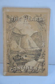
Chicago Burlington and Quincy RR The Heart of the Continent Book-1882JM Hobby Supply and Railroad Artifact Auctions4.4(127)See Sold PriceFeb 24, 2024
19thc Colton Map, Comparitive Size of Lakes & IslandsConnoisseur Auctions3.9(336)See Sold PriceFeb 24, 2024
1853 Colton's Railroad & Township Map of Massachusetts, Rhode Island, and ConnecticutRail & Road Auctions4.6(165)See Sold PriceMar 07, 2024
Pair of Early Railroad Maps - 1862 Pittsburgh, Ft. Wayne & Chicago Railway and 1873 PennsylvaniaRail & Road Auctions4.6(165)See Sold PriceMar 07, 2024
Rand McNally Railroad Map Cabinet w/ 21 Railroad MapsRail & Road Auctions4.6(165)See Sold PriceMar 08, 2024
Rare 19thc Colton Map, Argentine Republic, Chile, Uruguay, PataguayConnoisseur Auctions3.9(336)See Sold PriceMar 16, 2024
Reprint From The Original Coltons Map 1855 No.30 Copyright 1967Rapid Estate Liquidators and Auction Gallery4.5(1.1k)See Sold PriceFeb 29, 2024