SoldCOLORED PRINT, MAP OF THE NEW CONTINENT, J. GIBSONFramed colored print on paper, "A Map of the New Continent", J. Gibson sculpt. (John Gibson, British,18th c.), sight: 8.5"h, 7"w, overall: 17"h, 15.5"w, 3.25lbs Start Price: $80.00See Sold Price
SoldAn Accurate Map of the Netherlands. Europa. 1773.Copper engraving, hand colored print titled, “A New and Accurate Map of the Netherlands from the Sieur Roberts Atlas with Improvements“. Drawn by G.Rollos. Engraved by J. Gibson.Published in FennSee Sold Price
An Accurate Map of the Netherlands. Europa. 1773.Copper engraving, hand colored print titled, “A New and Accurate Map of the Netherlands from the Sieur Roberts Atlas with Improvements“. Drawn by G.Rollos. Engraved by J. Gibson.Published in FennSee Sold Price
SoldMap of the New Continent of North and South AmericaAntique map of the New Continent including South and North America signed on bottom right J Gibson - condition is nice but the fold line has separated on the one side.See Sold Price
SoldMap of North + South America, by J. GibsonHistoric Maps1758 Map of North and South America, by Gibson c. 1758, "A MAP OF THE NEW CONTINENT According to Its Greatest Diametrical Length...," Engraved by J. Gibson, Very Fine. This uncoloSee Sold Price
Gibson / Sayer: Antique Map of Western Hemisphere, 1786Map: A New Map of the Whole Continent of America Divided into North and South and West Indies wherein are exactly Described the United States of North America Cartographer: J. Gibson / R. Sayer PlaceSee Sold Price
Gibson/Sayer: Antique Map of Western Hemisphere, 1786Map: A New Map of the Whole Continent of America Divided into North and South and West Indies wherein are exactly Described the United States of North America Cartographer: J. Gibson / R. Sayer PlaceSee Sold Price
SoldJ. Cary New Map of Part of the USJohn Cary, English, 1754-1835. Hand colored engraved map entitled "A New Map of Part of the United States of America, Exhibiting The Western Territory, Kentucky, Pennsylvania, Maryland, Virginia &c. ASee Sold Price
SoldJ.M. Atwood, American (19th century)J.M. Atwood, American (19th century) Phelp's National Map of the US, A Traveler's Guide 1848, signed J.M. Atwood, New York, in print, R.C. Colored engraving, 24 1/2 in. X 28 1/2 in. framed together wiSee Sold Price
SoldFenning & Collyer 1765 Print. Mount Vesuvius, ItalyCopper Plate Published 1764-65, London for "A New System of Geography: or, A General Description of the World" by Daniel Fenning & Joseph Collyer. Maps by G. Rollos, J. Gibson and others, mostly basedSee Sold Price
SoldDe Cordova Map of the State of Texas 1850Map of the State of Texas Compiled from the Records of...the State by Robert Creuzbaur. Jacob De Cordova (1808-1868). Hand-colored lithograph. New York: J. Atwood, 1850. Second Edition. 35 x 31 1/2 inSee Sold Price
SoldMap of the State of ConnecticutHand-colored Lithograph. New York: J.B. Beers & Co., 1886. 52 1/8 x 47 1/4 inches, 57 x 51 3/4 inches framed. Includes table giving 1880 population and dates of settlement or organization of towns, arSee Sold Price
SoldJ.T. LLOYD, HUDSON RIVER, NEW YORK TOURIST /J.T. LLOYD, HUDSON RIVER, NEW YORK TOURIST / TOPOGRAPHICAL MAP, hand-colored lithograph, titled "Topographical Map of the Hudson River from the head of navigation at Troy to its confluence with the ocSee Sold Price
SoldAN ANTEBELLUM MAP, "J. De Cordova's Map of the State ofAN ANTEBELLUM MAP, "J. De Cordova's Map of the State of Texas," NEW YORK, 1856, hand colored lithograph on paper, with hand inscribed pencil inscriptions, the campaign notes beginning near BrownsvilleSee Sold Price
De Cordova Map of the State of TexasJ. De Cordova's Map of the State of Texas Compiled from the records of the General Land Office of the State by Robert Creuzbaur, Houston. Jacob De Cordova (1808-1868). Hand-colored lithograph. New YorSee Sold Price
SoldFlorida Lithograph MapFlorida, No. 32. Hand-colored lithographed map. New York: J.H. Colton, 1853. 12 1/2 x 15 1/4 inches visible, 23 x 25 inches framedSee Sold Price
SoldTwo Framed 19th Century Hand-colored Maps of New YoTwo Framed 19th Century Hand-colored Maps of New York City, 1836, J. Disturnell, and 1846, G.W. and C.B. Colton Map of the Country Thirty Miles Round the City of New York, respective sight size 22 x 2See Sold Price
Large Folio of Sketches, Maps, Prints, ArtworkLarge folio of artist's sketches, three vintage Italian colored prints, maps of Greece, Beethoven portrait, New York skyline, landscape watercolor, early 20th century serigraph, European picture, sheeSee Sold Price
SoldLarge Folio of Sketches, Maps, Prints, ArtworkLarge folio of artist's sketches, three vintage Italian colored prints, maps of Greece, Beethoven portrait, New York skyline, landscape watercolor, early 20th century serigraph, European picture, sheeSee Sold Price
SoldGroup Six Small Hand Colored Prints & EngravingsGroup of six small hand colored prints and engravings including a 1697 map of New England and New York printed in London c. 1830, Yale College and State House and others. One framed, not examined outSee Sold Price
SoldAntique Hand Colored Engraved Map NEW YORK STATE SmithDetails: This nicely hand-colored engraved map of New York State was designed by J. Calvin Smith and published by J. Disturnell circa 1852. Featuring insets of New York City and the St. Lawrence RiveSee Sold Price
Sold1858 Framed Map of North AmericaTitle: 1858 Framed Map of North America Medium: Ink on Paper/Glass/Wood Dimensions: 18.5"X21" Map of North America dated 1858. Engraved and published by J.H. Colton in New York. Hand colored. Map holdSee Sold Price
Sold(2) ATLAS MINIMUS MAP PAGES, J. GIBSON & E. BOWEN(lot of 2) Framed hand colored pages from the Atlas Minimus by John Gibson (British, 1750-1792) and improved by Emanuel Bowen (English, 1694?-1767), comprising: (1) "Turky in Asia", plate 30; (1) "EgySee Sold Price
MAP -- NEW YORK -- J. H. FRENCH. The State of NewMAP -- NEW YORK -- J. H. FRENCH. The State of New York from New and Original Surveys Under the Direction of J. H. French, C.E.Syracuse: Robert Pearsal Smith, 1860. Hand-colored map of New YoSee Sold Price
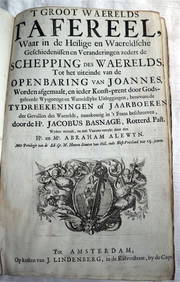
ACOBUS BASAGNE c1710 Theological History Numerous Engravings by De Hooghe Rare!Luis Porretta Fine Arts4.3(10)See Sold PriceMar 02, 2024
MARTINET / DE VRIES Catechism of Nature 4 Vol. Set c1788 Engravings Rare!Luis Porretta Fine Arts4.3(10)See Sold PriceMar 02, 2024
Willem Blaeu, Etc. 17th C. Antiquarian Maps, 2Auctions at Showplace4.6(740)See Sold PriceMar 17, 2024
Mitchell - Map of the City of Washington (Washington, DC)Trillium Antique Prints & Rare Books4.5(32)See Sold PriceFeb 24, 2024
Audubon - Blue-grey Flycatcher. 70Trillium Antique Prints & Rare Books4.5(32)See Sold PriceFeb 24, 2024
Audubon - Fork-tailed Flycatcher. 52Trillium Antique Prints & Rare Books4.5(32)See Sold PriceFeb 24, 2024
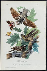
Audubon - Chuck-will's Widow. 41Trillium Antique Prints & Rare Books4.5(32)See Sold PriceFeb 24, 2024
Audubon - Common Osprey Fish Hawk. 15Trillium Antique Prints & Rare Books4.5(32)See Sold PriceFeb 24, 2024
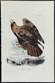
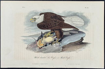
Audubon - White-headed Sea Eagle or Bald Eagle. 14Trillium Antique Prints & Rare Books4.5(32)See Sold PriceFeb 24, 2024
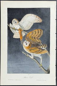
Audubon - Little Screech Owl. 40Trillium Antique Prints & Rare Books4.5(32)See Sold PriceFeb 24, 2024
Carl J. Sundevall (1801 - 1875) Set of 4 Bird Prints - Dove - Woodpecker - DuckProverde Auctions4.3(3)See Sold PriceFeb 28, 2024