SoldColored Map of Louisiana, c. 1910, showing theColored Map of Louisiana, c. 1910, showing the parishes, gilt framed, H.- 13 in., W.- 10 in.See Sold Price
SoldGroup of Twenty-Four Hand-Colored MapsGroup of Twenty-Four Antique Hand-Colored Maps , 17th to 19th c., majority showing provinces of Europe, unframed. Provenance: Property deaccessioned from the Louisiana State Museum, proceeds to be useSee Sold Price
SoldMAP OF NORTH AMERICA Hand colored, showing the EasternMAP OF NORTH AMERICA Hand colored, showing the Eastern part of North America, including the Louisiana and Florida Territory, c. 1740, large satirical title cartouche of the Mississippi Bubble investmeSee Sold Price
SoldMap of Louisiana, c. 1805, showing the parishes,Map of Louisiana, c. 1805, showing the parishes, presented in a walnut frame, H.- 16 3/4 in., W.- 20 5/8 in.See Sold Price
SoldNicolas De Fer (1646-1720, French), "Carte De LaNicolas De Fer (1646-1720, French), "Carte De La Louisiane et De La Floride", hand colored engraved map, c. 1760, showing the Indian tribes, framed, H.- 13 1/2 in., W.- 8 7/8 insight 13" x 9".See Sold Price
SoldHand Colored Map of Louisiana, early 20th c., presentedHand Colored Map of Louisiana, early 20th c., presented in a silvered frame, H.- 12 1/2 in., W.- 10 in.See Sold Price
SoldHand Colored Map of Louisiana, early 20th c., presentedHand Colored Map of Louisiana, early 20th c., presented in a silvered frame, H.- 12 1/2 in., W.- 10 in.See Sold Price
SoldTwo Louisiana Maps, 19th c., consisting of aTwo Louisiana Maps, 19th c., consisting of a colored example, 1829, by A. Finley, Philadelphia; and a colored Gray's New Map of Louisiana, c.a 1890, with an insert for the city of New Orleans and theSee Sold Price
SoldHand Colored 'Gulf of Bengal' MapHand Colored 'Gulf of Bengal' Map c.1700, showing the east coast of India and Ceylon (Sri Lanka), oriented to the west by Jan Jansson Height: 18.25 inches, Width: 21.25 inches (sight) Frame Size: 27.0See Sold Price
SoldHand-Colored Map of England by JansonAn Antique Hand-Colored Map of England, 18th c., by Janson, showing the counties of Cumbria and Westmorland, sight 17 1/4 in. x 21 3/4 inSee Sold Price
SoldMaps 19th-20th Cent. Mixed Lot of 10 Large MapsIncl 3 Maps of Italy from the Times Atlas (1895) Map of Cuba by Estevanez (C1910) Large Hand Colored Map of Historical France by Andriveau-Goujon (C1850) Plus 5 Large 20th Century Maps, incl Port de DSee Sold Price
SoldCivil War Map, 20th c., colored lithograph, showing theCivil War Map, 20th c., colored lithograph, showing the confederate and union states, presented in a polychromed frame, H.- 14 3/4 in., W.- 22 1/4 in.See Sold Price
Sold18th c. Florida Map - Herman MollFLORIDA, CALLED BY YE FRENCH LOUISIANA & C., hand colored engraved map by Herman Moll (1688-1732), originally appeared in Moll's Atlas Minor (1736). 8 1/8" x 11" plate, 8 3/8" x 11 1/8" sight, 15" x 1See Sold Price
SoldJansson Map of Overijssel, c. 1650,Jansson Map of Overijssel, c. 1650,map, "Ditio Trans-Isulana", by Johannes Jansson, Holland, c. 1650, colored map showing Overijssel Region of the Netherlands, top oriented to the west, three decoratiSee Sold Price
SoldFederal Pocket Map of Louisiana pub.FinleyA Federal Pocket Map of Louisiana, c. 1820, hand-colored engraving, published by Anthony Finley, Philadelphia, the leather booklet with Finley's advertisement stating, in part, "New and Correct PocketSee Sold Price
SoldLarge Colored Map of Louisiana, 1907, from the RandLarge Colored Map of Louisiana, 1907, from the Rand McNally Indexed Atlas of the World, double folio, showing railroads, presented in a mahogany frame with a gilt liner, H.- 19 1/4 in., W.- 25 3/4 in.See Sold Price
SoldT.S. Hardee, "Map of Louisiana showing topographicalT.S. Hardee, "Map of Louisiana showing topographical features, prepared for the medical and surgical memoirs of Joseph Jones, M.D. by T.S. Hardee, Civil Engineer," 1879, colored engraving, presented iSee Sold Price
SoldColored Map of Louisiana, 1911, by Rand McNally, fromColored Map of Louisiana, 1911, by Rand McNally, from the indexed atlas, showing The Railroads, presented in a blond mahogany frame, H.- 19 3/4 in., W.- 27 5/8 in.See Sold Price
SoldMap of Louisiana, 20th c., hand colored, by theMap of Louisiana, 20th c., hand colored, by the Geographical Publishing Co., Chicago, framed, H.- 15 1/8 in., W.- 21 1/4 in.See Sold Price
SoldGroup of Six Prints, 19th c., consisting of aGroup of Six Prints, 19th c., consisting of a hand-colored map of Louisiana, 1866, from Harper's Weekly, framed, together with 5 hunting prints after John Leech - "The Richest Commoner's First Jump,"See Sold Price
SoldMap of Louisiana, 20th c., hand colored, by theMap of Louisiana, 20th c., hand colored, by the Geographical Publishing Co., Chicago, framed, H.- 15 1/8 in., W.- 21 1/4 in.See Sold Price
SoldA. Finley, Map of Louisiana, 19th c., hand-colored,A. Finley, Map of Louisiana, 19th c., hand-colored, framed, H.- 9 in., W.- 11 1/2 in.See Sold Price
SoldMOLL, HERMAN. A Map of New France Containing Canada,MOLL, HERMAN. A Map of New France Containing Canada, Louisiana &c. in Nth America. Hand-colored engraved map of colonial North America. 7¾x10¾ inches sheet size, ample margins; mounted to foSee Sold Price
A. Finley," Map of Louisiana," 19th c., hand-colored,A. Finley," Map of Louisiana," 19th c., hand-colored, presented in a gilt silver beaded frame, H.- 9 1/2 in., W.- 12 in.See Sold Price
Lake Superior and Mississippi River RR 1869 Seven Percent Bonds Book/Report-1869JM Hobby Supply and Railroad Artifact Auctions4.4(126)See Sold PriceFeb 24, 2024
Union Pacific RR Map of the United States-1926JM Hobby Supply and Railroad Artifact Auctions4.4(126)See Sold PriceFeb 24, 2024
RARE MARATHON TIRES TIN SIGN W/ AUTOMOBILE GRAPHIC.Dan Morphy Auctions4.2(1.3k)See Sold PriceFeb 24, 2024
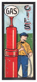
RARE HAND PAINTED ITHACA SERVICE STATION SIGN W/ PUMP AND ATTENDANT GRAPHIC.Dan Morphy Auctions4.2(1.3k)See Sold PriceFeb 24, 2024
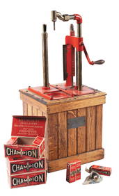
S.F. BOWSER & CO. SELF MEASURING COUNTERTOP OIL DISPENSER W/ CHAMPION SPARK PLUGS COUNTERTOP DISPLAYDan Morphy Auctions4.2(1.3k)See Sold PriceFeb 24, 2024
VISIBLE GASOLINE ONE PIECE ETCHED SPHERE GLOBE.Dan Morphy Auctions4.2(1.3k)See Sold PriceFeb 24, 2024
GILBERT & BARKER CURB STYLE PUMP RESTORED IN PURE GASOLINE.Dan Morphy Auctions4.2(1.3k)See Sold PriceFeb 25, 2024
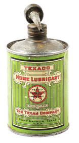
TEXACO HOME LUBRICANT CONE TOP HANDY OILER W/ SPOUT.Dan Morphy Auctions4.2(1.3k)See Sold PriceFeb 25, 2024
PHILIP NORMAN FSA Hand Colored Engraving c1910 Loch White Fairies SIGNED Listed ScotlandLuis Porretta Fine Arts4.3(10)See Sold PriceMar 02, 2024
A J HANDFORD British Lithographer Rome from Mount Aventi Signed c1910 FramedLuis Porretta Fine Arts4.3(10)See Sold PriceMar 02, 2024
CHARLES ROLLIN c1828 Ceasar Hand Colored Africa Military MapLuis Porretta Fine Arts4.3(10)See Sold PriceMar 02, 2024
Early 1900's Railway Service Map, Illinois, Ohio, Indiana, Kentucky, TennesseeConnoisseur Auctions4(333)See Sold PriceFeb 24, 2024
HAMMOND'S READY REFERENCE HISTORICAL ATLAS 1920North American Artifact Auctions4.6(182)See Sold PriceApr 20, 2024
[CHICAGO]. Rare Pre-Fire Illinois Map: “Blanchard’s Map of ...Potter & Potter Auctions4.6(539)See Sold PriceMar 07, 2024
Two Hand-Colored 19th Century Maps of New Orleans and Louisiana, Larger- H.- 12 1/2 in., W.- 15 1/2Crescent City Auction Gallery4.3(229)See Sold PriceMar 08, 2024


![[CHICAGO]. Rare Pre-Fire Illinois Map: “Blanchard’s Map of ... (1 of 2)](https://p1.liveauctioneers.com/928/318880/171361260_1_x.jpg?height=282&quality=70&version=1707501302)