SoldCary's large two sheet map of Scotland 1801Title: A New Map of Scotland from the Latest Authorities... Author: Cary, John Description: Copper-engraved map, hand-colored in outline. On two sheets, each approx. 44x101 cm. (17¼x39¾"), matted anSee Sold Price
New Map of Scotland from the Latest Authorities, byTitle: New Map of Scotland from the Latest Authorities, by John Cary Publication Date:1801-08-01 Cartographer: Cary, John Publisher: J. Cary Brief Description: Two sheets not joined together. Bright cSee Sold Price
Cary's New Map of Scotland 1801Title: A New Map of Scotland Author: Carey, John Description: Copper-engraved map, hand-colored; on 4 sheets joined together. 90x101 cm. (35½x40").Large, detailed map of Scotland at the beginning ofSee Sold Price
New Map of Scotland from the Latest Authorities, byTitle: New Map of Scotland from the Latest Authorities, by John Cary Publication Date: 1801-08-01 Cartographer: Cary, John Publisher: J. Cary Dimensions: 17.75 X 42 Additional Information: Two sheetsSee Sold Price
Sydney Hall: Map of Scotland, 1847Map: Scotland Maker: Adam & Charles Black, Sydney Hall Date: 1847 Size: Folio, 32 x 22.5 inches Very large two sheet map of Scotland showing railroads and highways, topography. Very detailed. Best atlSee Sold Price
ScotlandPublication Date: 1847 Title: Scotland Cartographer: Sidney Hall Publisher: Adam & Charles Black Height: 32 Width: 22.5 Very large two sheet map of Scotland showing railroads and highways, topography.See Sold Price
SoldScotland.- Cary (John) A New Map of Scotland from theScotland.- Cary (John) A New Map of Scotland from the latest authorities, large four sheet map of Scotland, not joined, with inset maps of the Shetlands and Orkney, engravings with hand-colouring, eacSee Sold Price
SoldJohn Cary. a New Map of Scotland. 1801.Hand Colored Map. 21" x 25" with huge margins. Edge wear which can be easily matted out with large margins still present.See Sold Price
SoldArmstrong (Marcus)Armstrong (Marcus) A New Map of Scotland or North Britain, with large decorative title cartouche, engraved map with outline hand-colouring, in two parts, unjoined, each sheet two sheets joinedSee Sold Price
SoldCary, JohnCary, John A new map of Scotland, from the latest authorities. London, 1801, one sheet on linen, approx 94cm high by 106cm wide, hand coloured in outline, some foxing and offsetting, paper slipcase, wSee Sold Price
SoldLarge folding map of England 1833Heading: Author: Cary, John Title: Cary's Six Sheet Map of England and Wales, with Part of Scotland: On Which Are Carefully Laid Down All the Direct and Principal Cross Roads, the Course of the RiverSee Sold Price
Cary's Improved Map of England and WalesCary (John) Cary's Improved Map of England and Wales, with a considerable portion of Scotland, planned upon a scale of two statute miles to one inch, title, index map and 65 map sheets, engravSee Sold Price
SoldCary (John) A New Map of ScotlandCary (John) A New Map of Scotland,with inset maps of the Shetland and the Orkney Islands, 4 engraved map sheets with original hand-colouring, to form one large map, each c.450 x 505mm., with vSee Sold Price
SoldA large coloured new map of Worcestershire 'dividedA large coloured new map of Worcestershire 'divided into hundreds' by John Cary dated 1801. Also a monochromatic map of the county of Derby by C&I Greenwood, published 1830. Two items.See Sold Price
SoldJohn Rocque, Large 2 Sheet Map, 1780John Rocque (1709-1762) , "England and Wales, Drawn from the most accurate Surveys...", large two-sheet map from Sayer's "General Atlas", 1780, engraved, with outline color, elaborate cartouche, combiSee Sold Price
SoldJohn Rocque, Map of Ireland, Engraved, 1780John Rocque (1709-1762) , "A Map of the Kingdom of Ireland, divided into provinces, counties...", large two-sheet map from Sayer's "General Atlas", 1780, engraved with outline color, elaborate cartoucSee Sold Price
Black: England And Wales.Map: England And Wales Maker: Adam & Charles Black, Sidney Hall Publishing Date: 1847 Size: Folio - 32.00 H X 21.75 inches Very large two sheet map of great britain showing railroads and highways, topSee Sold Price
Western Half of Pennsylvania | Eastern Half ofc1899 Title: Western Half of Pennsylvania | Eastern Half of Pennsylvania Cartographer: CRAM, GEO. F. Publisher: CRAM, GEO. F. Height: 21.75 Width: Very large two-sheet map with excellent detail of topSee Sold Price
Ohio [Southern Sheet] | Ohio [Northern Sheet]Title/Content of Map: Ohio [Southern Sheet] | Ohio [Northern Sheet] Cartographer: CRAM, GEORGE F. Date: 1899 Publisher: GEO. F. CRAM Size: Height - 21.8Width Large two-sheet map with railroads and plaSee Sold Price
Western Part of North and South Carolina | Eastern PartTitle/Content of Map: Western Part of North and South Carolina | Eastern Part of North and South Carolina Date: c1899 Cartographer: CRAM, GEO. F. Size: 22.5X35 Very large two-sheet map with excellentSee Sold Price
England And Wales.Publication Date: 1847 Title: England And Wales. Cartographer: Sidney Hall Publisher: Adam & Charles Black Height: 32 Width: 21.75 Very large two sheet map of Great Britain showing railroads and highwSee Sold Price
SoldIndia.- Wyld (James) Map of the Peninsula of India,India.- Wyld (James) Map of the Peninsula of India, from the 19th Degree of North Latitude, to Cape Comorin, large two-sheet map of India with part of Ceylon in the lower right, engraving with some ouSee Sold Price
SoldIndia.- Wyld (James) Map of the Peninsula of India,India.- Wyld (James) Map of the Peninsula of India, from the 19th Degree of North Latitude, to Cape Comorin, large two-sheet map of India with part of Ceylon in the lower right, engraving with some ouSee Sold Price
SoldCHATELAIN, HENRI ABRAHAM. Carte Tres CurieuseCHATELAIN, HENRI ABRAHAM. Carte Tres Curieuse de la Mer du Sud . . . sur les principaux Pays de l'Amerique tant Septentrionale que Meridionale. Large two-sheet engraved map joined, 825x1420 mm, marginSee Sold Price
Union Pacific RR Map of the United States-1926JM Hobby Supply and Railroad Artifact Auctions4.4(127)See Sold PriceFeb 24, 2024
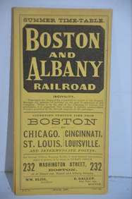
Boston and Albany RR March 17, 1881 Public TimetableJM Hobby Supply and Railroad Artifact Auctions4.4(127)See Sold PriceFeb 24, 2024
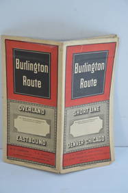
Chicago Burlington and Quincy RR November 30, 1887 Public TimetableJM Hobby Supply and Railroad Artifact Auctions4.4(127)See Sold PriceFeb 24, 2024
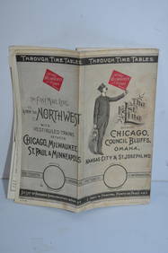
Chicago Milwaukee and St Paul RY March 1, 1889 Public TimetableJM Hobby Supply and Railroad Artifact Auctions4.4(127)See Sold PriceFeb 24, 2024
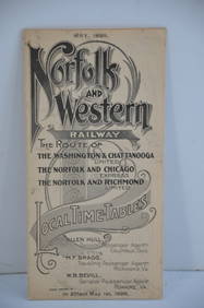
Norfolk and Western RY May 1898 Public TimetableJM Hobby Supply and Railroad Artifact Auctions4.4(127)See Sold PriceFeb 24, 2024
LARGE LATE 17TH C. DUTCH CHART OF CANADA, GREAT LAKES, NEW FRANCE, LABRADOR, HUDSON BAY, BY PIERREThomaston Place Auction Galleries4.4(394)See Sold PriceFeb 24, 2024
LATE 16TH C. MAP OF SCOTLAND BY MERCATOR, FRAMEDThomaston Place Auction Galleries4.4(394)See Sold PriceFeb 24, 2024
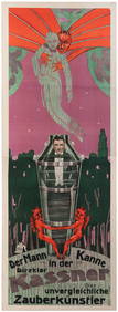
KASSNER, Alois (1887 – 1970). Der Mann in Der Kanne. Direkt...Potter & Potter Auctions4.6(550)See Sold PriceFeb 24, 2024
JOYCE WIELAND: TRUE PATRIOT LOVE. 1971, 1st. ED.Toronto Book Auctions4.3(13)See Sold PriceMar 07, 2024
[Constructivism]. The general plan of reconstruction of Moscow. - Moscow: Moscow Worker, 1936. -ARTMAXIMUM4.3(4)See Sold PriceMar 14, 2024


![Ohio [Southern Sheet] | Ohio [Northern Sheet] (1 of 2)](https://p1.liveauctioneers.com/5584/167533/84481060_1_x.jpg?height=282&quality=70&version=1588715327)


![[Constructivism]. The general plan of reconstruction of Moscow. - Moscow: Moscow Worker, 1936. - (1 of 6)](https://p1.liveauctioneers.com/6171/320219/172084257_1_x.jpg?height=282&quality=70&version=1708525949)


