ATLAS of ANTIENT GEOGRAPHY by SAMUEL BUTLER 1843John McInnis Auctioneers,LLC4.5(505)See Sold PriceFeb 24, 2024
18TH C. ANTIQUE MAP: FRENCH & INDIAN WAR, FRAMEDThomaston Place Auction Galleries4.4(393)See Sold PriceFeb 24, 2024
Rand McNally Railroad Map Cabinet w/ 21 Railroad MapsRail & Road Auctions4.6(165)See Sold PriceMar 08, 2024
Keith Haring - Ink on New York Map, Best Buddies, Inscribed, Signed, and DatedSapphire Auction Gallery4(67)See Sold PriceMar 02, 2024
LATE 17TH C. FRENCH MAP OF THE NEW WORLD BY ALEXIS-HUBERT JAILLOT (1632-1712)Thomaston Place Auction Galleries4.4(393)See Sold PriceFeb 24, 2024
Central Railroad of New Jersey Map of Sandy Hook Route-ca. 1903JM Hobby Supply and Railroad Artifact Auctions4.4(127)See Sold PriceFeb 24, 2024
Lot of Six Mixed Atlas Box Cars-HO Scale-New in BoxJM Hobby Supply and Railroad Artifact Auctions4.4(127)See Sold PriceFeb 25, 2024
Rand McNally/Santa Fe Railroad Map of Iowa-1912JM Hobby Supply and Railroad Artifact Auctions4.4(127)See Sold PriceFeb 24, 2024
NICOLAES VISSCHER (NETHERLANDS, 1618-1709) MAP OF THE NEW WORLDThomaston Place Auction Galleries4.4(393)See Sold PriceFeb 24, 2024
17TH C. WORLD MAP BY NICOLAES VISSCHER (NETHERLANDS, 1618-1709)Thomaston Place Auction Galleries4.4(393)See Sold PriceFeb 24, 2024
Lot of Six Mixed Atlas Cabooses-HO Scale-New in BoxJM Hobby Supply and Railroad Artifact Auctions4.4(127)See Sold PriceFeb 25, 2024
SoldCary, John 1806 Large Map of Shropshire. CamdenCopper Engraved Map Published 1806 by John Stockdale, London for a new and enlarged Edition of William Camden's "Britannia" by Richard Gough. Maps by John Cary. Paper Size: 22 x 17 inch (56 x 43cm) VeSee Sold Price
Cary, John 1806 Large Map of Shropshire. CamdenCopper Engraved Map Published 1806 by John Stockdale, London for a new and enlarged Edition of William Camden's "Britannia" by Richard Gough. Maps by John Cary. Paper Size: 22 x 17 inch (56 x 43cm) VeSee Sold Price
Cary, John 1806 Large Map of Shropshire. CamdenCopper Engraved Map Published 1806 by John Stockdale, London for a new and enlarged Edition of William Camden's "Britannia" by Richard Gough. Maps by John Cary. Paper Size: 22 x 17 inch (56 x 43cm) VeSee Sold Price
Cary, John 1806 LG Map of Worcestershire. CamdenCopper Engraved Map Published 1806 by John Stockdale, London for a new and enlarged Edition of William Camden's "Britannia" by Richard Gough. Maps by John Cary. Paper Size: 22 x 17 inch (56 x 43cm) GoSee Sold Price
Cary, John 1806 LG Map of Worcestershire. CamdenCopper Engraved Map Published 1806 by John Stockdale, London for a new and enlarged Edition of William Camden's "Britannia" by Richard Gough. Maps by John Cary. Paper Size: 22 x 17 inch (56 x 43cm) GoSee Sold Price
SoldCary, John 1806 LG Map of Westmoreland from CamdenCopper Engraved Map Published 1806 by John Stockdale, London for a new and enlarged Edition of William Camden's "Britannia" by Richard Gough. Maps by John Cary. Paper Size: 22 x 17 inch (56 x 43cm) WaSee Sold Price
SoldA map of Georgia the Carolinas Floridas and Bahamas by John Cary 1806John Cary, a large, early 19th century engraved, colored map titled "A New Map of Part of the United States of North America Containing the Carolinas and Georgia, Also the Floridas and part of the BahSee Sold Price
Cary (John) Cary's New ItineraryCary (John) Cary's New Itinerary:third edition, large folding engraved map with tears and tape repairs, possibly lacking a section, contemporary tree calf, for Cary, 1806; and the ninth editioSee Sold Price
SoldCary (John) Cary's New ItineraryCary (John) Cary's New Itinerary:third edition, large folding engraved map with tears and tape repairs, possibly lacking a section, contemporary tree calf, for Cary, 1806; and the ninth editioSee Sold Price
SoldFour early 19th century U.S. maps,each with original hand-coloring: John Cary, [A New Map of North America], London, 1806, image 18-1/4 x 20-1/4 in., [several large tears sealed with archival tape, minor stains and losses]; [Gli StatiSee Sold Price
SoldCary, John 1812 Large Hand Col Map of England & Wales"A New Map of England and Wales. Adapted to Cary's New Itinerary" Hand Coloured Copper Engraved Map Published 1812, London for "Cary's Traveller's Companion" by John Cary. Paper Size: 19 x 15 inch (48See Sold Price
SoldJohn Cary 1806, Three Maps of North AmericaThree hand colored maps of North America by John Cary, London, 1806. 1st map - "A New Map of North America" showing continent of North America. 2nd map - "A New Map of Part of the United States contaiSee Sold Price
SoldSHROPSHIRE MAP JOHN CARY FRAMED 1793 U.K.Original Shropshire map by John Cary. Dated Jan 1st, 1793. Slight wear to top left of map. Measures 16"x14 1/2" framed. Map measures 11"x9". Comes with original Atlas text page affixed to back of framSee Sold Price
SoldBritain.- Cary (John) Cary's Reduction of His Large MapNO RESERVE Britain.- Cary (John) Cary's Reduction of His Large Map of England and Wales, with Part of Scotland, detailed map of the counties, market towns, roads, post routes and canals, engraving witSee Sold Price
JOHN CARY 1806 A NEW MAP OF NORTH AMERICAJOHN CARY 1806 A NEW MAP OF NORTH AMERICA: Double page map engraved and published by John Cary, 1806. Hand tinted. sight size 19 1/2'' x 21 1/2'', framed 21 1/2'' x 23 1/2''.See Sold Price
SoldJohn Cary Map, 1806John Cary, "A New Map of North America from the Latest Authorities", London, 1806, hand-colored engraved map, showing the U.S. after the Louisiana Purchase and before the exploration by Lewis & Clark,See Sold Price
SoldCary (John) Cary's Reduction of his Large Map of ECary (John) Cary's Reduction of his Large Map of England and Wales, with part of Scotland,including the east coast of Ireland and the Isle of Man, with part of France at the lower right, engraSee Sold Price
SoldCary (John) Cary's Reduction of his Large Map of ECary (John) Cary's Reduction of his Large Map of England and Wales, with part of Scotland,including the east coast of Ireland and the Isle of Man, with part of France at the lower right, engraSee Sold Price
Cary (John) Cary's Reduction of his Large Map of ECary (John) Cary's Reduction of his Large Map of England and Wales, with part of Scotland,including the east coast of Ireland and the Isle of Man, with part of France at the lower right, engraSee Sold Price
Cary (John) Cary's Reduction of his Large Map of ECary (John) Cary's Reduction of his Large Map of England and Wales, with part of Scotland,including the east coast of Ireland and the Isle of Man, with part of France at the lower right, engraSee Sold Price
SoldCary (John) Map of England and WalesCary (John) Cary's Reduction of his Large Map of England and Wales,with part of Scotland, showing roads and canals, engraved map with original hand-colouring in oultine, 765 x 635mm., dissecteSee Sold Price
SoldA Map of ShropshireJ. Cary, A Map of Shropshire, engraving, from William Camden's Britannia, 1789 edition, 17 x 19.5 17 x 19.5See Sold Price
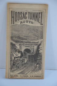
Fitchburg Railroad 1880 Hoosac Tunnel Route Public TimetableJM Hobby Supply and Railroad Artifact Auctions4.4(127)See Sold PriceFeb 24, 2024
The John Bull-Camden and Amboy RR Four Wheel Steam Loco-Bachmann-HO ScaleJM Hobby Supply and Railroad Artifact Auctions4.4(127)See Sold PriceFeb 25, 2024
17TH C. MAP OF THE BERKSHIRES BY JOHN SPEED, FRAMEDThomaston Place Auction Galleries4.4(393)See Sold PriceFeb 24, 2024
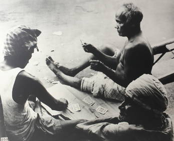
John Swope (American 1908-1979) Large format Silver Gelatin photograph CeylonGlobal Auctions Company4.3(36)See Sold PriceMar 03, 2024
Large Group of John F. Kennedy Campaign Ephemera With Rare Sealed PacketsDana J. Tharp Auctions4.7(271)See Sold PriceFeb 24, 2024
John Gilpin Prototype Colorway - Large - Royal Doulton Character JugLion and Unicorn4.8(1.9k)See Sold PriceFeb 27, 2024
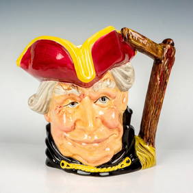
John Bull Prototype Colorway - Large - Royal Doulton Character JugLion and Unicorn4.8(1.9k)See Sold PriceFeb 27, 2024
Audubon, NYSE Best Watercolor Ed - Pair: Brown Pelican & Reddish EgretTrillium Antique Prints & Rare Books4.5(32)See Sold PriceFeb 24, 2024
Map: A 19thC engraved map titled Gloucestershire from the Best Authorities, after John Cary. Approx.Claydon Auctioneers Ltd4.3(125)See Sold PriceFeb 26, 2024
Map: A 19thC engraved and hand coloured map of Buckingham titled A New Map of BuckinghamshireClaydon Auctioneers Ltd4.3(125)See Sold PriceFeb 26, 2024
Map: A 19thC engraved map of West Riding, titled A Map of the North Part of the West Riding ofClaydon Auctioneers Ltd4.3(125)See Sold PriceFeb 26, 2024
1738 RUSSIA SIBERIA & GREAT TARTARY Description illustrated ANTIQUE in ENGLISHJasper524.5(9.9k)See Sold PriceFeb 27, 2024
Fielding (Henry) The Works, with An Essay on His Life and Genius by Arthur Murphy, 10 vol., newForum Auctions4.3(53)See Sold PriceFeb 29, 2024
NORTHERN AFRICA. Morocco Tunisia Algeria. Caravan routes. RAPKIN/TALLIS 1851 mapJasper524.5(9.9k)See Sold PriceFeb 28, 2024
NORTHERN AFRICA. Morocco Tunisia Algeria. Caravan routes.TALLIS/RAPKIN 1851 mapJasper524.5(9.9k)See Sold PriceFeb 28, 2024
NORTHERN AFRICA. Morocco Tunisia Algeria. Caravan routes. RAPKIN/TALLIS 1851 mapJasper524.5(9.9k)See Sold PriceFeb 28, 2024