SoldCary (John) Cary's Reduction of his Large Map of ECary (John) Cary's Reduction of his Large Map of England and Wales, with part of Scotland,including the east coast of Ireland and the Isle of Man, with part of France at the lower right, engraSee Sold Price
SoldCary (John) Cary's Reduction of his Large Map of ECary (John) Cary's Reduction of his Large Map of England and Wales, with part of Scotland,including the east coast of Ireland and the Isle of Man, with part of France at the lower right, engraSee Sold Price
Cary (John) Cary's Reduction of his Large Map of ECary (John) Cary's Reduction of his Large Map of England and Wales, with part of Scotland,including the east coast of Ireland and the Isle of Man, with part of France at the lower right, engraSee Sold Price
Cary (John) Cary's Reduction of his Large Map of ECary (John) Cary's Reduction of his Large Map of England and Wales, with part of Scotland,including the east coast of Ireland and the Isle of Man, with part of France at the lower right, engraSee Sold Price
SoldBritain.- Cary (John) Cary's Reduction of His Large MapNO RESERVE Britain.- Cary (John) Cary's Reduction of His Large Map of England and Wales, with Part of Scotland, detailed map of the counties, market towns, roads, post routes and canals, engraving witSee Sold Price
SoldCary (John) Map of England and WalesCary (John) Cary's Reduction of his Large Map of England and Wales,with part of Scotland, showing roads and canals, engraved map with original hand-colouring in oultine, 765 x 635mm., dissecteSee Sold Price
Cary: Large Map of England, Wales, Scotland, 1796Map: Cary’s reduction of his Large Map of England and Wales, with part of Scotland; Publication Date: 1796-02-20 Maker: John Cary, John Cary Publisher: John Cary Size: Elephant Folio – 29.3 H x 24See Sold Price
Cary's reduction of his Large Map of England and WalesTitle/Content of Map: Cary's reduction of his Large Map of England and Wales, with part of Scotland; Date Printed: 1796-02-20 Cartographer: John Cary Size (inches): 17.75x20.25 Comprehending the wholeSee Sold Price
SoldCary, John 1806 Large Map of Shropshire. CamdenCopper Engraved Map Published 1806 by John Stockdale, London for a new and enlarged Edition of William Camden's "Britannia" by Richard Gough. Maps by John Cary. Paper Size: 22 x 17 inch (56 x 43cm) VeSee Sold Price
Cary, John 1806 Large Map of Shropshire. CamdenCopper Engraved Map Published 1806 by John Stockdale, London for a new and enlarged Edition of William Camden's "Britannia" by Richard Gough. Maps by John Cary. Paper Size: 22 x 17 inch (56 x 43cm) VeSee Sold Price
Cary, John 1806 Large Map of Shropshire. CamdenCopper Engraved Map Published 1806 by John Stockdale, London for a new and enlarged Edition of William Camden's "Britannia" by Richard Gough. Maps by John Cary. Paper Size: 22 x 17 inch (56 x 43cm) VeSee Sold Price
SoldCary (John) Cary's Reduction of his Six Sheet MapCary (John) Cary's Reduction of his Six Sheet Map of the British Isles,with an inset map of the Shetland Isles, engraved map with full hand-colouring, 1270 x 990mm., dissected and linen-backedSee Sold Price
SoldCary, John 1812 Large Hand Col Map of England & Wales"A New Map of England and Wales. Adapted to Cary's New Itinerary" Hand Coloured Copper Engraved Map Published 1812, London for "Cary's Traveller's Companion" by John Cary. Paper Size: 19 x 15 inch (48See Sold Price
SoldBESS Cary (John) Cary's New Map of the county of EBESS Cary (John) Cary's New Map of the county of Essex, divided into hundredsexhibiting the whole of the turnpike and cross roads, the course of the rivers, market and borough towns, parishes,See Sold Price
Cary (John) Cary's New ItineraryCary (John) Cary's New Itinerary:third edition, large folding engraved map with tears and tape repairs, possibly lacking a section, contemporary tree calf, for Cary, 1806; and the ninth editioSee Sold Price
SoldCary (John) Cary's New ItineraryCary (John) Cary's New Itinerary:third edition, large folding engraved map with tears and tape repairs, possibly lacking a section, contemporary tree calf, for Cary, 1806; and the ninth editioSee Sold Price
SoldCary (John)Cary (John) Cary's New Itinerary: or an Accurate Delineation of the Great Roads... throughout England and Wales, sixth edition, large engraved folding map and 6 others, large map with tear, enSee Sold Price
SoldA map of Georgia the Carolinas Floridas and Bahamas by John Cary 1806John Cary, a large, early 19th century engraved, colored map titled "A New Map of Part of the United States of North America Containing the Carolinas and Georgia, Also the Floridas and part of the BahSee Sold Price
SoldLondon.- Cary (John) Cary's New and Accurate Plan ofLondon.- Cary (John) Cary's New and Accurate Plan of London and Westminster, the Borough of Southwark and parts adjacent, large detailed map showing from Kensington to the East India Docks, and from CSee Sold Price
SoldLondon.- Cary (John) Cary's New and Accurate Plan ofLondon.- Cary (John) Cary's New and Accurate Plan of London and Westminster, the Borough of Southwark and parts adjacent..., large detailed map showing from Kensington to the Stepney, and from CanonbuSee Sold Price
SoldCary (John) A New Map of ScotlandCary (John) A New Map of Scotland,with inset maps of the Shetland and the Orkney Islands, 4 engraved map sheets with original hand-colouring, to form one large map, each c.450 x 505mm., with vSee Sold Price
SoldCary's large two sheet map of Scotland 1801Title: A New Map of Scotland from the Latest Authorities... Author: Cary, John Description: Copper-engraved map, hand-colored in outline. On two sheets, each approx. 44x101 cm. (17¼x39¾"), matted anSee Sold Price
Early 1900's Railway Service Map, Illinois, Ohio, Indiana, Kentucky, TennesseeConnoisseur Auctions4(333)See Sold PriceFeb 24, 2024
[LITHOGRAPHY]. [DIE-CUT TRADE CARDS]. Group of Nine Large D...Potter & Potter Auctions4.6(539)See Sold PriceMar 07, 2024
Large lidded goblet ''JOHN OF AUSTRIA''Dr. Fischer Fine Art Auctions4.5(109)See Sold PriceMar 09, 2024
Map: A 19thC engraved map titled Gloucestershire from the Best Authorities, after John Cary. Approx.Claydon Auctioneers Ltd4.3(125)See Sold PriceFeb 26, 2024
Map: A 19thC engraved and hand coloured map of Buckingham titled A New Map of BuckinghamshireClaydon Auctioneers Ltd4.3(125)See Sold PriceFeb 26, 2024
Map: A 19thC engraved map of West Riding, titled A Map of the North Part of the West Riding ofClaydon Auctioneers Ltd4.3(125)See Sold PriceFeb 26, 2024
1738 RUSSIA SIBERIA & GREAT TARTARY Description illustrated ANTIQUE in ENGLISHJasper524.5(9.8k)See Sold PriceFeb 27, 2024
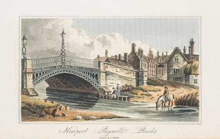
England.- Hassell (John) Tour of the Grand Junction, large paper copy, 24 hand-coloured aquatints,Forum Auctions4.3(52)See Sold PriceFeb 29, 2024
Bead by John Polhamus Coin Silver Gravy Ladle Retailed by J.E. Caldwell 7 1/2"Bidhaus4.3(747)See Sold PriceFeb 26, 2024
NORTHERN AFRICA. Morocco Tunisia Algeria. Caravan routes. RAPKIN/TALLIS 1851 mapJasper524.5(9.8k)See Sold PriceFeb 28, 2024
NORTHERN AFRICA. Morocco Tunisia Algeria. Caravan routes.TALLIS/RAPKIN 1851 mapJasper524.5(9.8k)See Sold PriceFeb 28, 2024
NORTHERN AFRICA. Morocco Tunisia Algeria. Caravan routes. RAPKIN/TALLIS 1851 mapJasper524.5(9.8k)See Sold PriceFeb 28, 2024
An Emory Boone Zuni sterling silver fetish bear cuff braceletJohn Moran Auctioneers, Inc.4.7(453)See Sold PriceMar 12, 2024


![[LITHOGRAPHY]. [DIE-CUT TRADE CARDS]. Group of Nine Large D... (1 of 6)](https://p1.liveauctioneers.com/928/318880/171361054_1_x.jpg?height=282&quality=70&version=1707501302)