ATLAS of ANTIENT GEOGRAPHY by SAMUEL BUTLER 1843John McInnis Auctioneers,LLC4.6(502)See Sold PriceFeb 24, 2024
18TH C. ANTIQUE MAP: FRENCH & INDIAN WAR, FRAMEDThomaston Place Auction Galleries4.4(386)See Sold PriceFeb 24, 2024
Rand McNally Railroad Map Cabinet w/ 21 Railroad MapsRail & Road Auctions4.6(165)See Sold PriceMar 08, 2024
Keith Haring - Ink on New York Map, Best Buddies, Inscribed, Signed, and DatedSapphire Auction Gallery4(67)See Sold PriceMar 02, 2024
LATE 17TH C. FRENCH MAP OF THE NEW WORLD BY ALEXIS-HUBERT JAILLOT (1632-1712)Thomaston Place Auction Galleries4.4(386)See Sold PriceFeb 24, 2024
Central Railroad of New Jersey Map of Sandy Hook Route-ca. 1903JM Hobby Supply and Railroad Artifact Auctions4.4(126)See Sold PriceFeb 24, 2024
Lot of Six Mixed Atlas Box Cars-HO Scale-New in BoxJM Hobby Supply and Railroad Artifact Auctions4.4(126)See Sold PriceFeb 25, 2024
Rand McNally/Santa Fe Railroad Map of Iowa-1912JM Hobby Supply and Railroad Artifact Auctions4.4(126)See Sold PriceFeb 24, 2024
NICOLAES VISSCHER (NETHERLANDS, 1618-1709) MAP OF THE NEW WORLDThomaston Place Auction Galleries4.4(386)See Sold PriceFeb 24, 2024
17TH C. WORLD MAP BY NICOLAES VISSCHER (NETHERLANDS, 1618-1709)Thomaston Place Auction Galleries4.4(386)See Sold PriceFeb 24, 2024
Lot of Six Mixed Atlas Cabooses-HO Scale-New in BoxJM Hobby Supply and Railroad Artifact Auctions4.4(126)See Sold PriceFeb 25, 2024
SoldCarre: Map of Sea of Japan & Korea, 1883Map: 'Carte des iles et mers du Japon, d'après les documents les plus récents' A large 19th century French sea chart of Japan, the sea of Japan, and the adjacent coast of north east Asia including tSee Sold Price
Carte Des Iles Et Mers Du Japon By Carré MapCarte Des Iles Et Mers Du Japon' By Carré. Sea Of Japan Chart. Large antique 19th century French sea chart by V. Carré. Korea 1883 Map. A large 19th century French sea chart of Japan, the sea of JapSee Sold Price
SoldHenri Abraham Chatelain - Carte Tres CurieuseHenri Abraham Chatelain (1684-1743), Carte Tres Curieuse De La Mer Du Sud, Contenant Des Remarques Mouvelles Et Tres Utiles Non Seulement Sur Les Parts Et Iles De Cette Mer (Very Curious Map of the SSee Sold Price
SoldCHATELAIN, HENRI. Carte Tres Curieuse de la Mer du Sud,CHATELAIN, HENRI. Carte Tres Curieuse de la Mer du Sud, Contenant des Remarques Nouvelles et Tres Utiles non Seulement sur les Ports et Iles de Cette Mer. Large engraved decorative map of the AmericasSee Sold Price
SoldHenri Abraham Chatelain - Carte Tres CurieuseHenri Abraham Chatelain (1684-1743), Carte Tres Curieuse De La Mer Du Sud, Contenant Des Remarques Mouvelles Et Tres Utiles Non Seulement Sur Les Parts Et Iles De Cette Mer (Very Curious Map of tSee Sold Price
Henri Abraham Chatelain (1684 - 1743) - Carte TresArtist: Henri Abraham Chatelain (1684 - 1743) Title: Carte Tres Curieuse de la Mer Du Sud, Contenant des Remarques Nouvelles Et Tres Utiles Sur Les Ports Et Iles de Cette Mer (A Ver y Special Map of tSee Sold Price
Robiquet: Antique Map Gulf of Mexico & Caribbean, 1853Title: Carte Generale des Iles Antilles et du Golfe du Mexique Dressee d'Apres les Travaux Anglais et Espagnols. Large French sea chart of the Gulf of Mexico and Caribbean, centered on Cuba Map maker:See Sold Price
SoldIsles du Japon & presquIsle de Corée'. Japan KoreaTITLE/CONTENT OF MAP: 'Carte des Isles du Japon et la Presqu Isle de Corée, avec les Costes de la Chine, depuis Pékin jusquà Canton [Map of the Islands of Japan, and the peninsula of Korea, with thSee Sold Price
SoldMap of Asia, Alaska insets, Diderot's ENCYCLOPEDI[Polar North & Asia]. Robert de Vaugondy. Carte Des Parties Nord Et Est De L'Asie Qui Comprend Les Cotes De La Russie Asiatique, Le Kmschatka, Le Iesso, Et Les Isles Du Japon...1772. Engraved map by HSee Sold Price
Isles du Japon & presquIsle de Corée'. Japan KoreaTITLE/CONTENT OF MAP: 'Carte des Isles du Japon et la Presqu Isle de Corée, avec les Costes de la Chine, depuis Pékin jusquà Canton [Map of the Islands of Japan, and the peninsula of Korea, with thSee Sold Price
SoldMexican Gulf Cuba Haiti Jamaica Puerto Rico 1875CARTE DES ILES ANTILLES DES ETATS DE L’AMERIQUE CENTRALE ET DU GOLFE DU MEXIQUE Very beautiful map of Antilles, central America and Mexican Gulf, coloured by hand, big size. Author: Brue, AdrieSee Sold Price
MAP, China, Korea & Japan, BellinChina, Korea & Japan. Jacques Nicolas Bellin, Carte des Isles du Japon et la Presqu Isle de Coree avec les Costes de la Chine Depuis Pekin Jusqua Canton, from Prevost's Histoire Generale des Voyages��See Sold Price
1773 Bellin Map of Japan, Korea and Coastal China --Title: 1773 Bellin Map of Japan, Korea and Coastal China -- Carte des Isles du Japon et la Presqu Isle de Coree avec les Costes de la Chine Depuis Pekin Jusqua Canton Cartographer: J Bellin Year / PlaSee Sold Price
1773 Bellin Map of Japan, Korea and Coastal China --Title/Content of Map: 1773 Bellin Map of Japan, Korea and Coastal China -- Carte des Isles du Japon et la Presqu Isle de Coree avec les Costes de la Chine Depuis Pekin Jusqua Canton Cartographer: J BeSee Sold Price
Bellin map of Japan 1773Title: Carte des Isles du Japon et la Presqu'Isle de Coree avec les Costes de la Chine Depuis Pekin Jusqu'a Canton Author: Bellin, Jacques Nicolas Description: Copper-engraved map, hand-colored (laterSee Sold Price
1773 Bellin Map of Japan, Korea and Coastal China --Title: 1773 Bellin Map of Japan, Korea and Coastal China -- Carte des Isles du Japon et la Presqu Isle de Coree avec les Costes de la Chine Depuis Pekin Jusqua Canton Cartographer: J Bellin Year / PlaSee Sold Price
Soldcopper-engraved mapFramed copper-engraved map, ''Carte des parties Nord et Est de l'Asie qui Comprend les Cotes de la Russie Asiatique, le Kamschatka, le Jesso, et les Isles du Japon,'' by M. de Vaugondy (French, 18th cSee Sold Price
MAP - Gulf of Mexico & Caribbean. BrueGulf of Mexico & Caribbean. Adrien Hubert Brue, Carte des Iles Antilles ou Indes Occidentales, du Golfe du Mexique et d'une Partie des Pays Adjacents, 1825 (dated). Hand Color. The beautifully engraveSee Sold Price
De Vaugondy map of Northeast Asia 1772Title: Carte des parties Nord et Est de l'Asie qui Comprend les Côtes de la Russie Asiatique, le Kamschatka, le Jesso, et les Isles du Japon, dressée en 1764 par M***, Nouvelle édition réduite parSee Sold Price
SoldNorthwest coast in latter 18th centuryHeading: Author: Robert de Vaugondy, Gilles and Didier Title: Carte des parties Nord et Est de l'Asie qui Comprend les Côtes de la Russie Asiatique, le Kamschatka, le Jesso, et les Isles du Japon, dSee Sold Price
SoldNorthwest coast in latter 18th centuryHeading: Author: Robert de Vaugondy, Gilles and Didier Title: Carte des parties Nord et Est de l'Asie qui Comprend les Côtes de la Russie Asiatique, le Kamschatka, le Jesso, et les Isles du Japon, dSee Sold Price
SoldElwe (Jan Barend) Partie de la Nouvelle Grande CarElwe (Jan Barend) Partie de la Nouvelle Grande Carte des Indes Orientales,contenant les Empires de la Chine du Japon, et les Isles Philippines, sheet 2 of Elwe's 4-sheet map of Asia, engravedSee Sold Price
SoldNicolas de Fer world mapCartographer: Nicholas de Fer Title: Carte de la Mer du Sud, et des Costes d’Amerique et d’Asie, Situees sur cette Mer .... [in set with] Carte de la Mer du Nord, et des Costes d’Amerique, d'EurSee Sold Price
SoldChatelain Map: Carte Tres Curieuse De La Mer SudFramed antique map, Henri Abraham Chatelain, Carte Tres Curieuse De La Mer Sud. Contenant Des Remarques Nouvelles et Tres Utiles Non Seulement Sur Les Ports et Iles De Cette Mer. Large map of the AmerSee Sold Price
[MAPS]. DUFOUR, Auguste-Henri (1795-1865). Bound Volume of ...Potter & Potter Auctions4.6(539)See Sold PriceMar 07, 2024
Map of St. Kitts and Nevis Depot de la Marine, Paris, 1758Global Auctions Company4.3(36)See Sold PriceMar 03, 2024
Duval - Pair: Map of Georgia & Map of Moscow, RussiaTrillium Antique Prints & Rare Books4.5(30)See Sold PriceFeb 24, 2024
Duval - Pair: Map of India & Map of MaldivesTrillium Antique Prints & Rare Books4.5(30)See Sold PriceFeb 24, 2024
1758 MAP PARTIE DE LA MER GLACIALE contenants La Nouvelle Zemble RUSSIA antiqueJasper524.5(9.8k)See Sold PriceFeb 27, 2024
Railways & Transport.- [Prospectus] The Dorking, Brighton, and Arundel Atmospheric Railway, byForum Auctions4.3(52)See Sold PriceFeb 29, 2024
1764 Bellin Chart of Three South Haitian Bays -- Carte des Bayes du Mesle des Flamands et deJasper524.5(9.8k)See Sold PriceFeb 27, 2024
Côte occidentale de l'Afrique. W Africa.Senegal Gambia rivers.D’ANVILLE 1751 mapJasper524.5(9.8k)See Sold PriceFeb 28, 2024
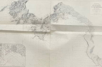
MER MEDITERRANEE ILES BALEARES MAJORQUE/ DU CAP BLANCO A L'ILE DRACONERA/ 1890Churchill Galleries3.7(213)See Sold PriceFeb 26, 2024
MER MEDITERRANEE / CORSE DU CAP PERTUSATO A LA POINTE DE SENETOSE LES MOINES Carte levee en 1884 etChurchill Galleries3.7(213)See Sold PriceFeb 26, 2024


![[MAPS]. DUFOUR, Auguste-Henri (1795-1865). Bound Volume of ... (1 of 2)](https://p1.liveauctioneers.com/928/318880/171361279_1_x.jpg?height=282&quality=70&version=1707501302)


![Railways & Transport.- [Prospectus] The Dorking, Brighton, and Arundel Atmospheric Railway, by (1 of 1)](https://p1.liveauctioneers.com/5458/319736/171654703_1_x.jpg?height=282&quality=70&version=1708010439)