ATLAS of ANTIENT GEOGRAPHY by SAMUEL BUTLER 1843John McInnis Auctioneers,LLC4.6(502)See Sold PriceFeb 24, 2024
18TH C. ANTIQUE MAP: FRENCH & INDIAN WAR, FRAMEDThomaston Place Auction Galleries4.4(386)See Sold PriceFeb 24, 2024
Rand McNally Railroad Map Cabinet w/ 21 Railroad MapsRail & Road Auctions4.6(165)See Sold PriceMar 08, 2024
Keith Haring - Ink on New York Map, Best Buddies, Inscribed, Signed, and DatedSapphire Auction Gallery4(67)See Sold PriceMar 02, 2024
LATE 17TH C. FRENCH MAP OF THE NEW WORLD BY ALEXIS-HUBERT JAILLOT (1632-1712)Thomaston Place Auction Galleries4.4(386)See Sold PriceFeb 24, 2024
Central Railroad of New Jersey Map of Sandy Hook Route-ca. 1903JM Hobby Supply and Railroad Artifact Auctions4.4(126)See Sold PriceFeb 24, 2024
Lot of Six Mixed Atlas Box Cars-HO Scale-New in BoxJM Hobby Supply and Railroad Artifact Auctions4.4(126)See Sold PriceFeb 25, 2024
Rand McNally/Santa Fe Railroad Map of Iowa-1912JM Hobby Supply and Railroad Artifact Auctions4.4(126)See Sold PriceFeb 24, 2024
NICOLAES VISSCHER (NETHERLANDS, 1618-1709) MAP OF THE NEW WORLDThomaston Place Auction Galleries4.4(386)See Sold PriceFeb 24, 2024
17TH C. WORLD MAP BY NICOLAES VISSCHER (NETHERLANDS, 1618-1709)Thomaston Place Auction Galleries4.4(386)See Sold PriceFeb 24, 2024
Lot of Six Mixed Atlas Cabooses-HO Scale-New in BoxJM Hobby Supply and Railroad Artifact Auctions4.4(126)See Sold PriceFeb 25, 2024
SoldIsles du Japon & presquIsle de Corée. Japan Korea ChinaTITLE/CONTENT OF MAP: 'Carte des Isles du Japon, & la Presqu Isle de Corée, avec les Côtes de la Chine, depuis Pékin jusquà Canton [Map of the Islands of Japan, and the peninsula of Korea, with thSee Sold Price
SoldIsles du Japon & presquIsle de Corée'. Japan KoreaTITLE/CONTENT OF MAP: 'Carte des Isles du Japon et la Presqu Isle de Corée, avec les Costes de la Chine, depuis Pékin jusquà Canton [Map of the Islands of Japan, and the peninsula of Korea, with thSee Sold Price
Isles du Japon & presquIsle de Corée'. Japan KoreaTITLE/CONTENT OF MAP: 'Carte des Isles du Japon et la Presqu Isle de Corée, avec les Costes de la Chine, depuis Pékin jusquà Canton [Map of the Islands of Japan, and the peninsula of Korea, with thSee Sold Price
1773 Bellin Map of Japan, Korea and Coastal China --Title: 1773 Bellin Map of Japan, Korea and Coastal China -- Carte des Isles du Japon et la Presqu Isle de Coree avec les Costes de la Chine Depuis Pekin Jusqua Canton Cartographer: J Bellin Year / PlaSee Sold Price
1773 Bellin Map of Japan, Korea and Coastal China --Title/Content of Map: 1773 Bellin Map of Japan, Korea and Coastal China -- Carte des Isles du Japon et la Presqu Isle de Coree avec les Costes de la Chine Depuis Pekin Jusqua Canton Cartographer: J BeSee Sold Price
1773 Bellin Map of Japan, Korea and Coastal China --Title: 1773 Bellin Map of Japan, Korea and Coastal China -- Carte des Isles du Japon et la Presqu Isle de Coree avec les Costes de la Chine Depuis Pekin Jusqua Canton Cartographer: J Bellin Year / PlaSee Sold Price
MAP, China, Korea & Japan, BellinChina, Korea & Japan. Jacques Nicolas Bellin, Carte des Isles du Japon et la Presqu Isle de Coree avec les Costes de la Chine Depuis Pekin Jusqua Canton, from Prevost's Histoire Generale des Voyages��See Sold Price
Bellin map of Japan 1773Title: Carte des Isles du Japon et la Presqu'Isle de Coree avec les Costes de la Chine Depuis Pekin Jusqu'a Canton Author: Bellin, Jacques Nicolas Description: Copper-engraved map, hand-colored (laterSee Sold Price
SoldFRENCH BONNE MAP OF CHINA, KOREA & JAPAN, 18TH C.Framed engraving with hand coloring on paper, map of China, Korea, and Japan, "Empire De La Chine, Rme De Coree et Isles Du Japon," Rigobert Bonne (French, 1727-1794) cartographer, engraved by PietroSee Sold Price
SoldBonne map of China, Korea & Japan c.1780Title: Empire de la Chine, Rme de Corée et Isles du Japon Author: Bonne, Rigobert Description: Copper-engraved map, hand-colored (later). 23.5x34.5 cm. (9¼x13½"); hinged to mat, framed under plexigSee Sold Price
Bonne: Antique Map of Chinese Empire Korea & Japan 1780Map: Empire De La Chine, Rme. De Coree Et Isles Du Japon. Publication Date: 1780 Cartographer: BONNE, RIGOBERT Publisher: R. BONNE 1780 PARIS Size: Quarto – 9.25 H x 13.50 W Inches Par M. Bonne... SSee Sold Price
Tartarie Chinoise, Royaume de Corée &… Japon. China Korea Japan. BONNE 1788 mapTITLE/CONTENT OF MAP: Tartarie Chinoise, Royaume de Corée et Isles du Japon [Chinese Tartary, The Kingdom of Korea and the islands of Japan] DATE PRINTED: 1788 IMAGE SIZE: Approx 24.5 x 36.5cm, 9See Sold Price
Tartarie Chinoise, Royaume de Corée &… Japon. China Korea Japan. BONNE 1790 mapTITLE/CONTENT OF MAP: Tartarie Chinoise, Royaume de Corée et Isles du Japon [Chinese Tartary, The Kingdom of Korea and the islands of Japan] DATE PRINTED: 1790 IMAGE SIZE: Approx 24.5 x 36.5cm, 9See Sold Price
Tartarie Chinoise, Royaume de Corée &… Japon. China Korea Japan. BONNE 1790 mapTITLE/CONTENT OF MAP: Tartarie Chinoise, Royaume de Corée et Isles du Japon [Chinese Tartary, The Kingdom of Korea and the islands of Japan] DATE PRINTED: 1790 IMAGE SIZE: Approx 24.5 x 36.5cm, 9See Sold Price
Tartarie Chinoise, Royaume de Corée &… Japon. China Korea Japan. BONNE 1788 mapTITLE/CONTENT OF MAP: Tartarie Chinoise, Royaume de Corée et Isles du Japon [Chinese Tartary, The Kingdom of Korea and the islands of Japan] DATE PRINTED: 1788 IMAGE SIZE: Approx 24.5 x 36.5cm, 9See Sold Price
Tartarie Chinoise, Royaume de Corée & Japon. ChinaTITLE/CONTENT OF MAP: Tartarie Chinoise, Royaume de Corée et Isles du Japon [Chinese Tartary, The Kingdom of Korea and the islands of Japan] The top image on the right hand side shows the entire map.See Sold Price
Empire de la Chine, Royaume de Corée & Japon. ChinaTITLE/CONTENT OF MAP: Empire de la Chine, Royaume de Corée et Isles du Japon [The Empire of China, the Kingdom of Korea and the islands of Japan] The top image on the right hand side shows the entireSee Sold Price
Tartarie Chinoise, Royaume de Corée & Japon. ChinaTITLE/CONTENT OF MAP: 'Tartarie Chinoise, Royaume de Corée et Isles du Japon [Chinese Tartary, The Kingdom of Korea and the islands of Japan]' This map is folding hence the centrefold line may show oSee Sold Price
Soldle Rouge, Carte Du Japon et de la Coree, c.1748[Korea & Japan]. George Louis le Rouge. Carte Du Japon Et De La Coree. Paris: [1748]. Double-page engraved map. 8 x 12 3/4 in. From ''Atlas Nouveau Portatif.'' Phillips 607. Early outline hand-colorinSee Sold Price
SoldBonne (Ri) Empire de la Chine, Rme.Bonne (Rigobert) Empire de la Chine, Rme. de Corée et Isles du Japon,China and Japan, engraved map by André, with full hand-colouring, 235 x 350mm., central vertical fold, some offsetting, folSee Sold Price
SoldBonne (Rigobert) Empire de la ChineBonne (Rigobert) Empire de la Chine, Rme. de Corée et Isles du Japon,China and Japan, engraved map by André, with full hand-colouring, 235 x 350mm., central vertical fold, some offsetting, folSee Sold Price
SoldJapan, Russia, eastern Asia: 4 maps, [1747]-1829.[Russia/Japan]. 4 engraved maps, uncolored, very good condition overall. ++ Bonne. Tartarie Chinoise, Roy De Coree Et Isles Du Japon. c.1747. 8 7/8 x 13 1/4 in. ++ Thomas Bowen. The Russian Empire, InSee Sold Price
Sold5 maps: Japanese coast and China, [c. late 1700's[Japan/China]. 5 engraved maps, all uncolored but first listed. Largest image, 9 x 13 3/4. Smallest, 8 1/2 x 7 7/8 in. ++ Bonne. Empire De La Chine, Rme. De Coree Et Isles Du Japon. Engraved by ScattaSee Sold Price
SoldMAP, China, Korea & Japan, Bonne/LattreChina, Korea & Japan. Bonne/Lattre, L'Empire de la Chine d'Apres l'Atlas Chinois, avec les Isles du Japon, from Atlas Moderne, 1787 (circa). Hand Color. Beautifully engraved, decorative map of the ChiSee Sold Price
LARGE LATE 17TH C. DUTCH CHART OF CANADA, GREAT LAKES, NEW FRANCE, LABRADOR, HUDSON BAY, BY PIERREThomaston Place Auction Galleries4.4(386)See Sold PriceFeb 24, 2024
Famous Dealer Spink 1997 Form & Function Furniture from China Japan and KoreaSunburst Auction4.4(19)See Sold PriceFeb 24, 2024
SAVANN THAV (artiste cambodgien né en 1956) : Composition au fond rouge jaune et rouge. Toile. 100Valoir Pousse-Cornet4.3(4)See Sold PriceFeb 24, 2024
Map of St. Kitts and Nevis Depot de la Marine, Paris, 1758Global Auctions Company4.3(36)See Sold PriceMar 03, 2024
1760 MAP CARTE PARTICULIERE DE L'ISLE DE JUAN FERNANDES antique Robinson CrusoeJasper524.5(9.8k)See Sold PriceFeb 27, 2024
Picasso. Autre Chose Que De L’Enfant Beau, With Color Drypoint Engraving. Louis Broder 1957TheRedFinch Auctions4.4(24)See Sold PriceFeb 29, 2024
(2 Pc) Vintage Japanese & Korean Monkey / Bartender Mechanical ToysAkiba Galleries4.7(1.7k)See Sold PriceFeb 29, 2024
1764 Bellin Map of Lesser Antilles Northern Portion -- Petites Antilles ou Isles du Vent 3e. Partie.Jasper524.5(9.8k)See Sold PriceFeb 27, 2024
Carte du Canal de Mosambique…. Madagascar Bonne Esperance. BONNE 1780 mapJasper524.5(9.8k)See Sold PriceFeb 28, 2024
Carte de la Guinée, contenant…'. Guinea & Cape Verde islands. BONNE 1771 mapJasper524.5(9.8k)See Sold PriceFeb 28, 2024
Le Canal de Mosambique, l'Isle de Madagascar… Mozambique. Africa. BONNE 1788 mapJasper524.5(9.8k)See Sold PriceFeb 28, 2024
Le Canal de Mosambique, l'Isle de Madagascar… Mozambique. Africa. BONNE 1790 mapJasper524.5(9.8k)See Sold PriceFeb 28, 2024
Partie Occidentale de l’Afrique. West Africa coast Canary islands BONNE 1788 mapJasper524.5(9.8k)See Sold PriceFeb 28, 2024
Partie Occidentale de l'Ancien Continent… W Africa Macaronesia. BONNE 1780 mapJasper524.5(9.8k)See Sold PriceFeb 28, 2024
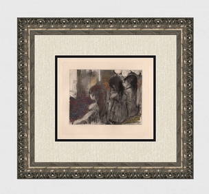
Edgar DEGAS 1938 Limited Edition Trois Filles Etching FramedKCM Galleries4.7(164)See Sold PriceFeb 25, 2024


![Japan, Russia, eastern Asia: 4 maps, [1747]-1829. (1 of 4)](https://p1.liveauctioneers.com/179/15522/5074186_1_x.jpg?height=282&quality=70&version=1206672512)