ATLAS of ANTIENT GEOGRAPHY by SAMUEL BUTLER 1843John McInnis Auctioneers,LLC4.6(502)See Sold PriceFeb 24, 2024
18TH C. ANTIQUE MAP: FRENCH & INDIAN WAR, FRAMEDThomaston Place Auction Galleries4.4(386)See Sold PriceFeb 24, 2024
Rand McNally Railroad Map Cabinet w/ 21 Railroad MapsRail & Road Auctions4.6(165)See Sold PriceMar 08, 2024
Keith Haring - Ink on New York Map, Best Buddies, Inscribed, Signed, and DatedSapphire Auction Gallery4(67)See Sold PriceMar 02, 2024
LATE 17TH C. FRENCH MAP OF THE NEW WORLD BY ALEXIS-HUBERT JAILLOT (1632-1712)Thomaston Place Auction Galleries4.4(386)See Sold PriceFeb 24, 2024
Central Railroad of New Jersey Map of Sandy Hook Route-ca. 1903JM Hobby Supply and Railroad Artifact Auctions4.4(126)See Sold PriceFeb 24, 2024
Lot of Six Mixed Atlas Box Cars-HO Scale-New in BoxJM Hobby Supply and Railroad Artifact Auctions4.4(126)See Sold PriceFeb 25, 2024
Rand McNally/Santa Fe Railroad Map of Iowa-1912JM Hobby Supply and Railroad Artifact Auctions4.4(126)See Sold PriceFeb 24, 2024
NICOLAES VISSCHER (NETHERLANDS, 1618-1709) MAP OF THE NEW WORLDThomaston Place Auction Galleries4.4(386)See Sold PriceFeb 24, 2024
17TH C. WORLD MAP BY NICOLAES VISSCHER (NETHERLANDS, 1618-1709)Thomaston Place Auction Galleries4.4(386)See Sold PriceFeb 24, 2024
Lot of Six Mixed Atlas Cabooses-HO Scale-New in BoxJM Hobby Supply and Railroad Artifact Auctions4.4(126)See Sold PriceFeb 25, 2024
Carey & Lea - Jamaica. 41This hand-colored map engraving was part of the atlas titled A Complete Historical, Chronological, and Geographical American Atlas, being A Guide to the History of North and South America, and the WesSee Sold Price
Carey & Lea: Antique Geographical Map of Jamaica, 1822Map: Geographical, Statistical, and Historical Map of Jamaica Publication Date: 1822 Authors: CAREY & LEA, FINLAYSON, J. Publisher: CAREY & LEA Size: Folio – 11.30 H x 12.00 W Inches Map detailing tSee Sold Price
Sold8 Maps from 1822 Carey & Lea Atlas Incl. Maryland8 Maps from 1822 Carey & Lea Atlas Incl. Maryland, Massachusetts, New Hampshire, Jamaica-- Dimensions: ---See Sold Price
SoldCarey & Lea Map of Rhode Island, 1822Cartographer: Carey & Lea Year/Place of Publishing: 1822, Philadelphia 1822 Carey and Lea Map of Rhode Island -- Geographical, Statistical, and Historical Map of Rhode Island. This excellent early mapSee Sold Price
Carey & Lea: Antique Map of Florida, 1827Map: 1827 Carey and Lea Florida Map -- Geographical, Statistical, and Historical Map of Florida Cartographer: Carey & Lea Year / Place: 1827, Philadelphia Map Dimensions: 22 x 17.6 in. Condition: VerySee Sold Price
Sold1821 Carey & Lea Map of North and South America1821 Carey & Lea map of North and South America. 1821 Geographical, Historical, and Statistical Map of America. from the third Philadelphia Edition. Printed by T. H. Palmer for M. Carey & Son, from thSee Sold Price
SoldCarey & Lea: Map of Palestina Antiqua, 1832Palestina Antiqua with inset of Jerusalem. Pub. 1832 by Carey & Lea. 7 x 9. Map of ancient Palestine with hand-colored outlines to delineate areas. Extremely light foxing in a few areas. Small repaireSee Sold Price
SoldCarey & Lea: Antique Map of the West Indies, 1826Map: Geographical Statistical and Historical Map of the West Indies Publication Date: 1826 Authors: CAREY & LEA, CAREY & LEA Publisher: CAREY & LEA Size: Folio – 12.00 H x 15.80 W Inches Map detailiSee Sold Price
SoldCarey & Lea: Antique Map of North America, 1822Map: Geographical, Statistical, and Historical Map of North America Publication Date: 1822 Authors: CAREY & LEA, FINLAYSON, J./J. YEAGER Publisher: CAREY & LEA Size: Double Folio – 13.75 H x 13.30 WSee Sold Price
SoldAntique Map of Louisiana, Carey & Lea, 1822Antique Map of Louisiana , "Geographical, Statistical and Historical Map of Louisiana", Philadelphia, Carey & Lea, 1822, 16 3/4 in. x 21 1/4 in., framed . Provenance: By repute, Arader Galleries, NewSee Sold Price
SoldCarey & Lea: Map of Syria, Mesopotamia, Assyria, 1832Syria, Mesopotamia, Assyria, &c. Pub. 1832 by Carey & Lea. 7 x 9. Antique hand colored map of Syria, Mesopotamia, Assyria, and other surrounding areas in the Ancient Middle East (mainly comprising modSee Sold Price
Carey & Lea: Antique View of Quebec City, 1823Map: Quebec Cartographer: Carey & Lea Place & Date: London / 1823 Size: 8 1/2" x 6 3/8" Condition: b&w; light overall age toning An evocative and beautifully engraved view of Quebec with ships and boaSee Sold Price
SoldCarey & Lea's 1822 map of U.S. engraved by TannerTitle: United States of America Author: Carey & Lea Description: Copper-engraved map, hand-colored. Engraved by B. Tanner. 43.2x54.5 cm. (17x21½").Important map of the United States, issued in CareySee Sold Price
SoldCarey & Lea: Antique View of Philadelphia, 1823Map: Philadelphia Cartographer: Carey & Lea Place & Date: London / 1823 Size: 8 1/2" x 6 3/8" Condition: b&w; overall age toning; some spotting, mostly along margins An atmospheric and beautifully engSee Sold Price
SoldCarey & Lea: Antique Map of Porto Rico & Virgin IslandsTitle/Content of Map: Porto Rico and Virgin Islands Date Printed: 1822 Cartographer: Henry C. Carey and Isaac Lea Material/Medium: Engraving Size: 17 3/4" x 22" sheet Atlas Folio, hard to find map ofSee Sold Price
Carey & Lea: Map of Oriens, 1832Oriens, P. E. Hamm. Pub. 1832 by Carey & Lea 7 x 9.5. Steel engraving by P.E. Hamm. Published by Carey & Lea in Philadelphia, 1832. Please note that this lot has a confidential reserve. When you leaveSee Sold Price
Sold1821 Carey & Lea Map of England1821 Carey & Lea map of England. Full original hand coloring. Geographical and Statistical Map of England (Cartouche: England & Wales divided into Circuits & Counties with the Principal High Roads). FSee Sold Price
Sold1838 Carey & Lea Map of Northern Italy -- ItaliaeTitle/Content of Map: 1838 Carey & Lea Map of Northern Italy -- Italiae Antiquae Pars Septemtrionalis. Cartographer: Carey & Lea Year/Place: 1838 c., Philadelphia Size: 6.8 X 9.1 in. Description: ThisSee Sold Price
1827 Carey & Lea Ohio Map -- Geographical, StatisticalCarey & Lea, 1827, Philadelphia, 17 x 21.8 in. with text panels This early map of Ohio is on a full folio sheet with English text below and on sides concerning the state's topography, climate, populatSee Sold Price
SoldMap of Pennsylvania, Carey & Lea 1828Title: Geographical, Historical and Statistical Map of Pennsylvania Subject: Pennsylvania Maker: Carey & Lea Date: 1827, Carey & Lea: Philadelphia Size: 11.8 x 17.8 inches Map detailing topography, toSee Sold Price
SoldMap of Massachusetts, Carey & Lea 1827Title: Geographical, Historical and Statistical Map of Massachusetts Subject: Massachusetts Maker: Carey & Lea Date: 1827, Carey & Lea: Philadelphia Size: 11.8 x 18.3 inches Map detailing counties, toSee Sold Price
SoldMap of New Hampshire, Carey & Lea 1829Title: Geographical, Historical and Statistical Map of New Hampshire Subject: New Hampshire Maker: Carey & Lea Date: 1827, Carey & Lea: Philadelphia Size: 11.8 x 8.8 inches Very detailed map showing cSee Sold Price
SoldCarey & Lea: Antique Geographical Map of Alabama, 1827Title/Content of Map: 1827 Carey & Lea Map of Alabama -- Geographical, Statistical, and Historical Map of Alabama Date Printed: 1827, Philadelphia Cartographer: Carey & Lea Size: 20.4x 16.5 in. This eSee Sold Price
SoldCarey & Lea: Antique View of Quebec City, 1823Quebec An evocative and beautifully engraved view of Quebec with ships and boats in the harbor, from the scarce London edition by Sherwood, Jones, and Co. of The Geography, HIstory, and Statistics ofSee Sold Price
ENGLISH TWO-PART CAMPAIGN CHEST Late 19th Century Height 43". Width 41". Depth 17".Eldred's4.7(409)See Sold PriceFeb 27, 2024
ALVATA (Franz Willy Hiltermann, 1911 - 41). The Mysterious ...Potter & Potter Auctions4.6(539)See Sold PriceFeb 24, 2024
Wonderful Hand Woven Floral Design Rug 41" X 24"Swisher Bros. Auction LLC4.4(241)See Sold PriceFeb 24, 2024
Carey, pub. 1796 - Map of the Tennassee State formerly part of North Carolina (Tennessee)Trillium Antique Prints & Rare Books4.5(30)See Sold PriceFeb 24, 2024
1822 MAP of LEEWARD ISLANDS GEOGRAPHICAL STATISTICAL HISTORICAL antique 17.5x22"Jasper524.5(9.8k)See Sold PriceFeb 27, 2024
1822 MAP of SOUTH AMERICA GEOGRAPHICAL STATISTICAL HISTORICAL antique 17.5x 22"Jasper524.5(9.8k)See Sold PriceFeb 27, 2024
1822 MAP of NORTH & SOUTH AMERICA GEOGRAPHICAL STATISTICAL HISTORICAL antiqueJasper524.5(9.8k)See Sold PriceFeb 27, 2024
1822 MAP of CHILI GEOGRAPHICAL STATISTICAL HISTORICAL antique 17.5x 22" CHILEJasper524.5(9.8k)See Sold PriceFeb 27, 2024
CONVEX BULLS EYE MIRROR, BLACK LINER, ORIG. GLASS 41" X 26" X 5"Carlsen Gallery, Inc.4.6(163)See Sold PriceMar 03, 2024
AMERICAN CHERRY STRETCHER BASE WORK TABLE 1 DROPLEAF & DRAWER (28" TALL X 41 1/4" X 25 1/2" OPEN 35Carlsen Gallery, Inc.4.6(163)See Sold PriceMar 03, 2024
18THC. CHIPPENDALE DROP LEAF TABLE W/ BALL & CLAW FEET (28 1/4" X 41" X 18 1/2" ) (OPEN 50" X 41")Carlsen Gallery, Inc.4.6(163)See Sold PriceMar 03, 2024
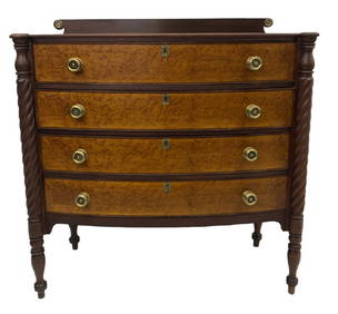
NEW ENGLAND 4 DRAWER BOW FRONT SHERATON CHEST FIGURED MAPLE DRAWER FRONTS (41" X 38" X 19")Carlsen Gallery, Inc.4.6(163)See Sold PriceMar 03, 2024
ANTIQUE SLANT FRONT DESK - 41" H X 37" W X 18" DTHOS. CORNELL GALLERIES, LTD./CORNELL AUCTIONS, OBJECTS, AND TRADE4.5(313)See Sold PriceFeb 24, 2024
41" Metal Garden Seat in Red PaintState Line Auctions & Estate Services4.6(275)See Sold PriceFeb 25, 2024
Pr of 41" Cast Aluminum 2 Handle PlantersState Line Auctions & Estate Services4.6(275)See Sold PriceFeb 25, 2024
CARNIVAL "FANTASY" CRUISE SHIP SCALE MODEL WITH DISPLAY CASE, SHIP 10.5 X 41 X 5, 13.25 X 48 X 10.25THOS. CORNELL GALLERIES, LTD./CORNELL AUCTIONS, OBJECTS, AND TRADE4.5(313)See Sold PriceFeb 24, 2024
American Queen Anne Cherry Highboy, Litchfield County, CT, 18th c., H.- 73 in., W.- 41 1/2 in., D.-Crescent City Auction Gallery4.3(229)See Sold PriceMar 09, 2024
Memoirs Of The Revolution Vol. 1 +2 By Lieut.-Gen Count Mathieu DumasRapid Estate Liquidators and Auction Gallery4.5(1.1k)See Sold PriceMar 02, 2024