MATTHEWS c1856 Map Of Upper Canada Ontario Indian Land Agency Divisions Scarce!Luis Porretta Fine Arts4.3(10)See Sold PriceMar 02, 2024
DEVINE c1856 Dr Salters Map Of Lake Huron Ontario Indian Lands etc. No. 7 ScarceLuis Porretta Fine Arts4.3(10)See Sold PriceMar 02, 2024
DUNLEVIE c1856 Map Counties Of Gaspe & Bonaventure Quebec Canada SCARCE! #1Luis Porretta Fine Arts4.3(10)See Sold PriceMar 02, 2024
DUNLEVIE c1856 Map Counties Of Gaspe & Bonaventure Quebec Canada SCARCE! #2Luis Porretta Fine Arts4.3(10)See Sold PriceMar 02, 2024
Map UNITED COUNTIES LEEDS & GRENVILLE by Walling 1861 Rare Canada Map 5ft x 5ftLuis Porretta Fine Arts4.3(10)See Sold PriceMar 02, 2024
Ambroise TARDIEU c1822 Map Venice Napoleon Italian Campaign 17" x 11"Luis Porretta Fine Arts4.3(10)See Sold PriceMar 02, 2024
SoldCarey & Lea: Antique View of Philadelphia, 1823Map: Philadelphia Cartographer: Carey & Lea Place & Date: London / 1823 Size: 8 1/2" x 6 3/8" Condition: b&w; overall age toning; some spotting, mostly along margins An atmospheric and beautifully engSee Sold Price
Carey & Lea: Antique View of Philadelphia, 1823Map: Philadelphia Cartographer: Carey & Lea Place & Date: London / 1823 Size: 8 1/2" x 6 3/8" Condition: b&w; some foxing along margins An atmospheric and beautifully engraved riverfront view of PhilaSee Sold Price
Carey & Lea: Antique View of Quebec, 1823Map: Quebec Cartographer: Carey & Lea Place & Date: London / 1823 Size: 8 1/2" x 6 3/8" Condition: b&w; light overall age toning An evocative and beautifully engraved view of Quebec with ships and boaSee Sold Price
Carey & Lea: Antique View of Quebec City, 1823Map: Quebec Cartographer: Carey & Lea Place & Date: London / 1823 Size: 8 1/2" x 6 3/8" Condition: b&w; light overall age toning An evocative and beautifully engraved view of Quebec with ships and boaSee Sold Price
SoldCarey & Lea: Antique View of Quebec City, 1823Quebec An evocative and beautifully engraved view of Quebec with ships and boats in the harbor, from the scarce London edition by Sherwood, Jones, and Co. of The Geography, HIstory, and Statistics ofSee Sold Price
Carey & Lea: Antique Map of British North America, 1823Map: British Possessions in North Americ Cartographer: Carey & Lea Place & Date: London / 1823 Size: 9 1/2" x 7 1/2" The Canada map, extending from the Atlantic to the Rockies, from the scarce LondonSee Sold Price
SoldGeographical, Statistical, and Historical Map of AGeographical, Statistical, and Historical Map of America Detached from Carey and Lea's American Atlas of 1823, Philadelphia: H. C. Carey and I. Lea, 1822, sight size 20.5" x 16.5"See Sold Price
SoldCAREY, H. C. & I. LEA. United States of America.Carey & Lea Pocket Map of U.S. extending to the Rockies ca. 1823 39. [MAP]. CAREY, H. C. & I. LEA. United States of America. [Philadelphia, ca. 1823]. Copper-engraved map on onionskin, contempSee Sold Price
Sold[American Botanical], group lotBARTON, William P.C. A Flora of North America. Issues 33, 34, 35, and 36. Philadelphia: H.C. Carey & I. Lea, April - July, 1823. $5,800. 4 parts. 4to., (11 4/8 x 9 inches). Half-title, title-page, tabSee Sold Price
SoldAntique Map of Louisiana, Carey & Lea, 1822Antique Map of Louisiana , "Geographical, Statistical and Historical Map of Louisiana", Philadelphia, Carey & Lea, 1822, 16 3/4 in. x 21 1/4 in., framed . Provenance: By repute, Arader Galleries, NewSee Sold Price
Sold2 vols. Chapman, N. Elements of Theraputics and M2 vols. Chapman, N. Elements of Theraputics and Materia Medica. Philadelphia: H.C. Carey and I. Lea, 1823-1824. 8vo, contemp. sheep; rubbed & worn, joints tender or broken. Scattered light foxing, verSee Sold Price
Map of Washington, DC by Carey & Lea, 1825Washington, DC from American Atlas published by Carey & Lea in Philadelphia, 1825. Dimensions: 23” x 27” No Reserve Buyer pays shipping - ships from Ocean View, DESee Sold Price
Map of Washington, DC by Carey & Lea, 1825Washington, DC from American Atlas published by Carey & Lea in Philadelphia, 1825. Dimensions: 23” x 27” No Reserve This item ships from Ocean View, DE.See Sold Price
SoldMap of Washington, DC by Carey & Lea, 1825Original map by Carey & Lea from American Atlas published in Philadelphia, 1825. Dimensions: 23” x 27” No Reserve Buyer pays shipping. This item ships from Ocean View, DE.See Sold Price
SoldTN Map 1822, Lucas, Carey, & Lea"Geographical, Statistical, And Historical Map of Tennessee", drawn by Fielding Lucas, Jr., engraved by William Kneass, published by Henry C. Carey and Issac Lea, Philadelphia, 1822. From "A CompleteSee Sold Price
Sold(2) VOLUME 1ST AMERICAN EDITION WALTER SCOTT'Quentin Durward, A Romance' by the author of Waverley, Ivanhoe, &c. &c. Philadelphia, HC Carey and L Lea, Chestnut Street, 1823, full leather, applied gilt label, 4 1/2" x 7 1/4", 271/321 pp, bindingSee Sold Price
SoldBook: Scarce American atlasBook: Scarce American atlas A COMPLETE HISTORICAL, CHRONOLOGICAL, AND GEOGRAPHICAL AMERICAN ATLAS¦. Philadelphia: H. C. Carey and I. Lea, 1823. Provenance : From the library of August Kohn. August KSee Sold Price
Sold1827 Three-Vol Life of Napolean BounaparteThree-Volume set, “The Life of Napolean Bounaparte, Emperor of the French with a Preliminary View of the French Revolution”, by Sir Walter Scott, printed at Philadelphia by Carey, Lea, and Carey,See Sold Price
SoldNORRIS-PEPPER Family. The Holy Bible: ContainingNORRIS-PEPPER Family. The Holy Bible: Containing the Old and New Testaments.Philadelphia: H. C. Carey and I. Lea, 1823. Two volumes in one, tall thick 4to (287 x 225 mm). 31 engravings. ConSee Sold Price
SoldJohn Marshall's 2 Volume Book: Marshall's Washington,Signed hardcover two volume set of John Marshall's "The Life of George Washington", published by Carey & Lea, Philadelphia, 1832. Second edition, "Revised & Corrected by the Author". Stereotyped by J.See Sold Price
SoldTHE ROCKY MOUNTAINS , or Scenes, Incidents, andTHE ROCKY MOUNTAINS , or Scenes, Incidents, and Adventures in the Far West. In 2 Vols. IRVING, Washington. Philadelphia: Carey, Lea, & Blanchard, 1837; 1st Amer. Edition. Blue-green boards and spine.See Sold Price
SoldJane Austen "Persuasion," 1st US Ed., 2 vol.First American edition of Jane Austen's "Persuasion," 1832, Carey & Lea, Philadelphia, publishers, Griggs & Dickinson, printers. 2 vol. Original boards with muslin spines and paper labels, all in fairSee Sold Price
Charles Dickens "Pickwick Club," 1st US Ed., 2 volTwo volumes from the first American edition of Charles Dickens' "The Posthumous Papers of the Pickwick Club." Vol. 1 and 4. 1836-37, Carey, Lea & Blanchard, Philadelphia, publishers, Griggs & Co., priSee Sold Price
Charles Dickens "Pickwick Club," 1st US Ed., 2 volTwo volumes from the first American edition of Charles Dickens' "The Posthumous Papers of the Pickwick Club." Vol. 1 and 4. 1836-37, Carey, Lea & Blanchard, Philadelphia, publishers, Griggs & Co., priSee Sold Price
ATLAS of ANTIENT GEOGRAPHY by SAMUEL BUTLER 1843John McInnis Auctioneers,LLC4.6(502)See Sold PriceFeb 24, 2024
William Hart 1823 - 1894 Rare American 19th Century Hudson River School Luminous Forest Oil PaintingCurated Gallery Auctions4.6(120)See Sold PriceFeb 25, 2024
Antique European Impressionist Town View Architectural Landscape Original Oil PaintingCurated Gallery Auctions4.6(120)See Sold PriceFeb 25, 2024
Antique French Impressionist Landscape Signed Summer View Original Oil PaintingCurated Gallery Auctions4.6(120)See Sold PriceFeb 25, 2024
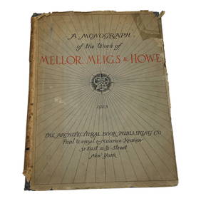
Antique 1923 Illustrated Architecture Firm Sample BookAbsolute Auction Gallery4.5(57)See Sold PriceFeb 28, 2024
Carey, pub. 1796 - A Chart of the West IndiesTrillium Antique Prints & Rare Books4.5(30)See Sold PriceFeb 24, 2024
Carey, pub. 1796 - Map of the State of MarylandTrillium Antique Prints & Rare Books4.5(30)See Sold PriceFeb 24, 2024
Carey, pub. 1796 - Map of GeorgiaTrillium Antique Prints & Rare Books4.5(30)See Sold PriceFeb 24, 2024
Carey, pub. 1796 - Map of The State of South CarolinaTrillium Antique Prints & Rare Books4.5(30)See Sold PriceFeb 24, 2024
Carey, pub. 1796 - Map of KentuckyTrillium Antique Prints & Rare Books4.5(30)See Sold PriceFeb 24, 2024
Carey, pub. 1796 - Map of the Tennassee State formerly part of North Carolina (Tennessee)Trillium Antique Prints & Rare Books4.5(30)See Sold PriceFeb 24, 2024
1822 MAP of LEEWARD ISLANDS GEOGRAPHICAL STATISTICAL HISTORICAL antique 17.5x22"Jasper524.5(9.8k)See Sold PriceFeb 27, 2024
1822 MAP of SOUTH AMERICA GEOGRAPHICAL STATISTICAL HISTORICAL antique 17.5x 22"Jasper524.5(9.8k)See Sold PriceFeb 27, 2024
1822 MAP of NORTH & SOUTH AMERICA GEOGRAPHICAL STATISTICAL HISTORICAL antiqueJasper524.5(9.8k)See Sold PriceFeb 27, 2024
1822 MAP of CHILI GEOGRAPHICAL STATISTICAL HISTORICAL antique 17.5x 22" CHILEJasper524.5(9.8k)See Sold PriceFeb 27, 2024
Edward Hull 1885 etching The View from the Terrace, Windsor Castle signedKCM Galleries4.7(164)See Sold PriceFeb 25, 2024
William Crothers Fitler (NY,1857-1915) oil painting antiqueBroward Auction Gallery4.8(277)See Sold PriceMay 19, 2024
Joachim Ferdinand Richardt - Set of 8 Prints - Topographical views of Castels in Sweden - SkabersjöProverde Auctions4.3(3)See Sold PriceFeb 28, 2024
Joachim Ferdinand Richardt - Set of 8 Prints - Topographical views of Castels in Sweden - RosendahlProverde Auctions4.3(3)See Sold PriceFeb 28, 2024
ANTIQUE VIEW OF VENICE WATERCOLOR PAINTING SIGNEDAntique Arena Inc.4.5(852)See Sold PriceMar 09, 2024
(2) MULTI-WICK LAMPS FOR MAGIC LANTERN CT MILLIGANAustin Auction Gallery4.7(1.2k)See Sold PriceApr 12, 2024


![[American Botanical], group lot (1 of 4)](https://p1.liveauctioneers.com/1968/49757/23264003_1_x.jpg?height=282&quality=70&version=1389039584)