SoldCapt. John C. Fremont Topographical Map of the road toFremont (Capt.) John C. Topographical map of the road from Missouri to Oregon commencing at the mouth of the Kansas in the Missouri River and ending at the mouth of the Wallah in the Columbia in SevenSee Sold Price
SoldRoad from Missouri to Oregon topographical mapsTopographical Maps of the Road from Missouri to Oregon in Seven Sections, 1846. Compiled by Charles Preuss, Assistant to John C. Fremont. Scale 10 miles to the inch. This series of seven maps accompanSee Sold Price
Sold[Map] Preuss & Fremont, Oregon Trail, 1846Charles Preuss and J. C. Fremont - "Topographical Map of the Road from Missouri to Oregon … in VII Sections" (Washington, by order of the Senate, printed in Baltimore by E. Weber, 1846) seven liSee Sold Price
Preuss & Freemont Oregon Trail MapPreuss, Charles (1803-1854), & Fremont, John Chalres (1813-1890). Topographical map of the road from Missouri to Oregon... Commencing at the Mouth of the Kansas in the Missouri River and Ending at theSee Sold Price
Sold1842 Fremont Map of the Rocky Mountainsmap "Exploring Expedition to the Rocky Mountains in the Year 1842, Oregon & North California in the Years 1843See Sold Price
SoldAFTER JOHN CARY, NEW MAP OF SUSSEX, C. 1801After John Cary (British 1754-1835), "A New Map of Sussex, Divided Into Hundreds, Exhibiting Its Roads, Rivers, Parks & C.", circa 1801, colored copper engraving, topographical map depicting the EngliSee Sold Price
SoldNICOLLET, JOSEPH N.; and FREMONT, JOHN C. MapNICOLLET, JOSEPH N.; and FREMONT, JOHN C. Map of the Hydrographical Basin of the Upper Mississippi River. Mammoth six-sheet engraved map unjoined, 2040x2415 mm overall; few minor nicks and tears nearSee Sold Price
SoldAn Early Virginia Map,from an E 17th C map by Capt. John Smith, having "The Virginian Sea", "Chesapeack Bay", etc. with folds as a pull-out from a book. Matted and framed under glass, visible image 13 1/4" high, 16 1/4" wiSee Sold Price
SoldMap of the Civil War, 1863Heading: (Civil War) Author: Perrine, Charles O. and Capt. John S. Bishop Title: Perrine's New Topographical War Map of the Southern States with a Chronology of the Great Rebellion [with] A Concise HiSee Sold Price
SoldMap of the Civil War, 1863Heading: (Civil War) Author: Perrine, Charles O. and Capt. John S. Bishop Title: Perrine's New Topographical War Map of the Southern States with a Chronology of the Great Rebellion [with] A Concise HiSee Sold Price
SoldNJ TOPOGRAPHICAL MAP CENTRAL HIGHLANDS MORRIS & SUSSEXNJ TOPOGRAPHICAL MAP CENTRAL HIGHLANDS MORRIS & SUSSEX COUNTIES 1888 JOHN C. SMOCK STATE GEOLOGIST, OVERALL DIMENSIONS INCLUDING FRAME 31 3/4 IN X 42 3/4 INSee Sold Price
SoldGeographical Memoir of John C. FremontGeographical memoir of John C. Fremont, record of his expedition through California and Oregon, published 1848, ''In illustration of his map of Oregon and California'' (no map included)See Sold Price
SoldSix Antique English Maps and PlansSix Antique English Maps and Plans , incl. four John Ogilby road maps, 17th c. (13 3/4 in. x 17 in.); and two plates of London showing Christopher Wren and John Evelyn's designs for the rebuilding ofSee Sold Price
Soldc.1648 Handcolored Map VON VIRGINIA - Jan JanssonHistoric Maps Hand-Colored "VON VIRGINIA" Map by Jan Jansson c. 1648 Map, Hand-Colored "VON VIRGINIA" (VIRGINIA) by Jan Jansson, after Capt. John Smith's landmark Map of 1612, Framed, Choice ExtremelySee Sold Price
SoldFremont, John C94. Fremont, John C.Memoirs of My Life. Volume 1 [all published]. Profusely illustrated, including large folding map at rear. 4to, leather-backed boards, spine gilt in 5 compartments; inner joints splSee Sold Price
SoldPreuss, Topographical Map of the Road…."Frémont's and Preuss' greatest contributions to the development of the West"-Goetzmann 118. [MAP]. PREUSS, Charles. Topographical Map of the Road from Missouri to Oregon Commencing aSee Sold Price
Sold[Americana] Fremont, J(ohn). C. Report of The Exploring Expedition to The Rocky Mountains in the[Americana] Fremont, J(ohn). C. Report of The Exploring Expedition to The Rocky Mountains in the Year 1842, and to Oregon and North California in the Years 1843-'44 Washington (D.C.): Gales and SeatonSee Sold Price
SoldFremont. Expedition...Rocky Mountains. 1845[Frontier] Fremont, John C. Report of the Exploring Expedition to the Rocky Mountains in the Year 1842, and to Oregon and North California in the Years 1843-44. Washington, Gales and Seaton, 1845. 8voSee Sold Price
SoldFremont. Expedition...Rocky Mountains. 1845[Frontier] Fremont, John C. Report of the Exploring Expedition to the Rocky Mountains in the Year 1842, and to Oregon and North California in the Years 1843-44. Washington, Gales and Seaton, 1845. 8voSee Sold Price
Fremont's report of exploring the RockiesHeading: Author: Fremont, John C. Title: Report of the Exploring Expedition to the Rocky Mountains Place Published: Washington Publisher:Gales and Seaton Date Published: 1845 DescriptiSee Sold Price
SoldFRAGMENT OF 17TH C. EXPLORER'S BOOK WITH MAP &"An Account of the Most Dangerous Voyage Perform'd by the Famous Capt. John Monck, In the Years 1619, and 1620. By the Special Command of Cristian IV, King of Denmark, Norway & etc. to Hudson's StraitSee Sold Price
Sold-. Morden (Robert) Hampshire-. Morden (Robert) Hampshire,engraved map with hand colouring, 365 x 420mm, [c.1695] § Ogilby (John) The Road From London to Lands End, being London to Winchester, engraved road map with handSee Sold Price
SoldJohn Ogilby etchingJohn Ogilby (Scottish 1600-1676)- ''The Road from Bristoll to Worcester'' road map- etching in color, 17th c., handling creases, soiling and scattered foxing. 12 1/8 x 17 1/4''See Sold Price
SoldJohn Ogiley hand-colored map- 18th c.John Ogiley- ''The Road From Oxford to Coventry- hand-colored map, fold down center as should be, some staining and foxing throughout. 15 x 18''See Sold Price
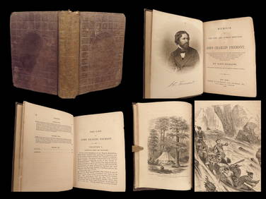
1856 CALIFORNIA 1st ed Memoir John C. Fremont Expeditions Oregon Trail IndiansSchilb Antiquarian Rare Books4.8(428)See Sold PriceMar 10, 2024
17TH C. MAP OF THE BERKSHIRES BY JOHN SPEED, FRAMEDThomaston Place Auction Galleries4.4(393)See Sold PriceFeb 24, 2024
17TH C. ENGLISH LINEAR MAP BY OGILBY, FRAMEDThomaston Place Auction Galleries4.4(393)See Sold PriceFeb 24, 2024
AMERICAN SCHOOL (Early 20th c) Two WorksJohn McInnis Auctioneers,LLC4.5(505)See Sold PriceFeb 25, 2024
1963 J.F.K. for US PRESIDENT RE-ELECTION MATERIALJohn McInnis Auctioneers,LLC4.5(505)See Sold PriceFeb 25, 2024
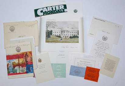
1977 INAUGURATION of PRESIDENT JIMMY CARTERJohn McInnis Auctioneers,LLC4.5(505)See Sold PriceFeb 25, 2024
Catherwood - General View of Uxmal, Taken from the Archway of Las Monjas, Looking SouthTrillium Antique Prints & Rare Books4.5(32)See Sold PriceFeb 24, 2024
Map: A 19thC engraved and hand coloured map of Buckingham titled A New Map of BuckinghamshireClaydon Auctioneers Ltd4.3(125)See Sold PriceFeb 26, 2024
1704 DESCRIPTION OF ALL THE SEATS OF THE PRESENT WARS OF EUROPE antique w/ MAPSJasper524.5(9.9k)See Sold PriceFeb 27, 2024
West Indies Islands. Guadaloupe. | Mariegalante &C. | Antigua.Jasper524.5(9.9k)See Sold PriceFeb 27, 2024
A 14ct Gold Half Hunter Pocket Watch by John Myers & Co Ltd of Westminster Bridge Road, London and CHannam's Auctioneers Ltd4.3(396)See Sold PriceFeb 27, 2024


![[Map] Preuss & Fremont, Oregon Trail, 1846 (1 of 3)](https://p1.liveauctioneers.com/523/81971/42494509_1_x.jpg?height=282&quality=70&version=1447274451)


![[Americana] Fremont, J(ohn). C. Report of The Exploring Expedition to The Rocky Mountains in the (1 of 4)](https://p1.liveauctioneers.com/65/289207/153001002_1_x.jpg?height=282&quality=70&version=1683915408)