ATLAS of ANTIENT GEOGRAPHY by SAMUEL BUTLER 1843John McInnis Auctioneers,LLC4.5(505)See Sold PriceFeb 24, 2024
18TH C. ANTIQUE MAP: FRENCH & INDIAN WAR, FRAMEDThomaston Place Auction Galleries4.4(393)See Sold PriceFeb 24, 2024
Rand McNally Railroad Map Cabinet w/ 21 Railroad MapsRail & Road Auctions4.6(165)See Sold PriceMar 08, 2024
Keith Haring - Ink on New York Map, Best Buddies, Inscribed, Signed, and DatedSapphire Auction Gallery4.1(67)See Sold PriceMar 02, 2024
LATE 17TH C. FRENCH MAP OF THE NEW WORLD BY ALEXIS-HUBERT JAILLOT (1632-1712)Thomaston Place Auction Galleries4.4(393)See Sold PriceFeb 24, 2024
Central Railroad of New Jersey Map of Sandy Hook Route-ca. 1903JM Hobby Supply and Railroad Artifact Auctions4.4(127)See Sold PriceFeb 24, 2024
Lot of Six Mixed Atlas Box Cars-HO Scale-New in BoxJM Hobby Supply and Railroad Artifact Auctions4.4(127)See Sold PriceFeb 25, 2024
Rand McNally/Santa Fe Railroad Map of Iowa-1912JM Hobby Supply and Railroad Artifact Auctions4.4(127)See Sold PriceFeb 24, 2024
NICOLAES VISSCHER (NETHERLANDS, 1618-1709) MAP OF THE NEW WORLDThomaston Place Auction Galleries4.4(393)See Sold PriceFeb 24, 2024
17TH C. WORLD MAP BY NICOLAES VISSCHER (NETHERLANDS, 1618-1709)Thomaston Place Auction Galleries4.4(393)See Sold PriceFeb 24, 2024
Lot of Six Mixed Atlas Cabooses-HO Scale-New in BoxJM Hobby Supply and Railroad Artifact Auctions4.4(127)See Sold PriceFeb 25, 2024
SoldFRAGMENT OF 17TH C. EXPLORER'S BOOK WITH MAP &"An Account of the Most Dangerous Voyage Perform'd by the Famous Capt. John Monck, In the Years 1619, and 1620. By the Special Command of Cristian IV, King of Denmark, Norway & etc. to Hudson's StraitSee Sold Price
SoldBook Plate and other mapsincluding; 17th c. (?) book page with Nubie (Africa) book plate, 1902 Rand McNally Middle East map (folded), Palestine map in Greeting from Israel card. map of South America, older map of Germany andSee Sold Price
SoldRARE 18TH C. EXPLORER'S BOOKPernety, Antoine Joseph; "The History of a Voyage to the Malouine (or Falklands) Islands, made in 1763 and 1764, Under the Command of M. de Bougainville, in Order to form a Settlement there: and of TwSee Sold Price
RARE 18TH C. EXPLORER'S BOOKPernety, Antoine Joseph; "The History of a Voyage to the Malouine (or Falklands) Islands, made in 1763 and 1764, Under the Command of M. de Bogainville, in Order to form a Settlement there: and of TwoSee Sold Price
Sold17th C. German Book.17th C. German book, hand made animal hide binding. Illustrated with maps. (The Kingdom of Kolen. Land state and time exploration from the best and the newest laws of the kingdom's own land rights. WiSee Sold Price
SoldLot of 16- 16th, 17th and 18th C BooksLot of 16- 16th, 17th and 18th C Books: Les Commentaires de Cesar, 1652 with map; Cleopatre, 1st part 1648; Historia delle Guerre, 1638; Roma Antica e Moderna; Lettres Politiques et Moralles de PlineSee Sold Price
SoldHAND COLORED ENGRAVED MAP, "CANDIA", 17THCHAND COLORED ENGRAVED MAP, "CANDIA", BOOK PLATE, 17TH CENTURY. SHEET 17 1/2 X 21 3/4" (CENTER FOLD)See Sold Price
SoldMaps of The Great Explorers Coffee TableVintage Coffee Table Shaped like Books with Maps of the Great Explorers, mid 20th c, painted wood. Dimensions: 18 x 33 x 27 inches.See Sold Price
SoldSEVEN 17TH AND 18TH C. ETCHINGS AND BOOK LEAVESIncludes two leaves from Sebastian Munster's 'Cosmographia,' c. 1590, one double-sided (pg. 1087-1088) leaf with page title 'Von Teutsch Lande,' with woodcut map of Regensburg and environs, and 'Das FSee Sold Price
THE VOLUME OF THE BOOKS CALLED APOCRYPHA,THE VOLUME OF THE BOOKS CALLED APOCRYPHA, a 17th century fragment, title vignette and map of the Holy Island, folio - a.f. - not subject to returnSee Sold Price
SoldFRAMED 17TH C. JAPANESE CALLIGRAPHYFragment from the Kokinwakashu (or the Kokinshu for short), the 'First Imperial Anthology of Japanese Poetry', Book 8. The Kokin and the Shin-kokin wakashu anthologies were written between the 8th toSee Sold Price
17th C. Map of ItalyCapitanata, Olim Mesapiae Et Iapygiae Pars; from Blaeu's Theatrum, 1650. Hand colored with decorative cartouche. Framed, 26" x 22.5". From Godspeed's Book Shop, Boston.See Sold Price
Sold17th C. Map of ItalyCapitanata, Olim Mesapiae Et Iapygiae Pars; from Blaeu's Theatrum, 1650. Hand colored with decorative cartouche. Framed, 26" x 22.5". From Godspeed's Book Shop, Boston.See Sold Price
SoldAn Early Virginia Map,from an E 17th C map by Capt. John Smith, having "The Virginian Sea", "Chesapeack Bay", etc. with folds as a pull-out from a book. Matted and framed under glass, visible image 13 1/4" high, 16 1/4" wiSee Sold Price
Sold17th c. Islamic Manuscript, Spells, IncantationsCa. 17th century manuscript. Loose leaves (formerly bound and likely a fragment), 8.5" x 6.25", [109] leaves, ink on laid. Housed in custom box. Many leaves water-stained, most leaves with frayed and/See Sold Price
17th C Handcolored Map of Tartariaa latter 17th c map of Tartaria, nicely handcolored. Text on verso. Measures 9 x 7". Fine condition. Reserve: $40.00 Shipping: Domestic: Flat-rate of $5.00 to anywhere within the contiguous U.S. InterSee Sold Price
SoldJoseph Schaigberger Sendbrief 17th C and Early MapLate 17thC / early 18thC Joseph Schaigberger Sendbrief; one of 24 books printed from 1686 to 1717 including various kinds of literature: reports, letters, dialogues, poems, hymns, prayers and morningSee Sold Price
Sold(2) 17TH C. CONTINENTAL HAND-COLORED MAPSIL BELLUNESE Con il FELTRINO with page from its German book on reverse, noted as 1647 framed under glass, image 14.75” by 19.5”; the other LUSATIA SUPERIOR Ex Officina Davids Funck Norumbergae matSee Sold Price
17th C Handcolored Map of Tartariaa latter 17th c map of Tartaria, nicely handcolored. Text on verso. Measures 9 x 7". Fine condition. Reserve: $40.00 Shipping: Domestic: Flat-rate of $5.00 to anywhere within the contiguous U.S. InterSee Sold Price
SoldGrp: 16th and 17th c. Maps of the World Hondius MLarge lot of 16th and 17th century maps of various parts of the world, many pages from books and atlases. By cartographers including Jodocus Hondius (1563-1612) and Herman Moll (ca. 1654-1732). SeveraSee Sold Price
Sold17th C Frederick De Wit Handcolored Engraving ChristLarge engraving, hand colored of Frederick De Wit (1629/30-1706), engraver most noted for his maps. This engraving of the Passion of Christ. Signed in type at bottom of engraving and listed place of pSee Sold Price
Sold17th c. French Breviary, w/ MssLE DIURNAL DU BREVIAIRE ROMAIN. Paris, 1646. 4.75" x 3". Wanting at least 4 leaves. Bound in period calf, WITH MANUSCRIPT ON VELLUM FRAGMENTS used by binder visible at front (see photos.) Work printedSee Sold Price
SoldPair of 17th c. MapsPair of 17th century maps, both by Timothy Pont: "Praefectura Kircubriensis… The Steuartrie of Kircubright" (measured from neatlines 21" x 16.5"); " "Lidalia vel Lidisdalia Regio" (Latin text to verSee Sold Price
SoldPAIR OF SANSON MAPS, 17TH CPAIR NICOLAS SANSON MAPS: From Sanson's Tabulae Geographicae, framed, and accompanied by an appraisal from C. Dickens, Fine, Rare and Collectible Books. Size in frames; 24 1/2" x 30". Sold as is.See Sold Price
LARGE LATE 17TH C. DUTCH CHART OF CANADA, GREAT LAKES, NEW FRANCE, LABRADOR, HUDSON BAY, BY PIERREThomaston Place Auction Galleries4.4(393)See Sold PriceFeb 24, 2024
17TH C. WORLD MAP BY NICOLAES VISSCHER (NETHERLANDS, 1618-1709)Thomaston Place Auction Galleries4.4(393)See Sold PriceFeb 24, 2024
LATE 17TH C. FRENCH MAP OF THE NEW WORLD BY ALEXIS-HUBERT JAILLOT (1632-1712)Thomaston Place Auction Galleries4.4(393)See Sold PriceFeb 24, 2024
17TH C. ANTIQUE MAP SIEGE OF LA ROCHELLE, FRANCE, FRAMEDThomaston Place Auction Galleries4.4(393)See Sold PriceFeb 24, 2024
17TH C. MAP OF THE BERKSHIRES BY JOHN SPEED, FRAMEDThomaston Place Auction Galleries4.4(393)See Sold PriceFeb 24, 2024
17TH C. ENGLISH LINEAR MAP BY OGILBY, FRAMEDThomaston Place Auction Galleries4.4(393)See Sold PriceFeb 24, 2024
Rare 19thc German Handcolored Costume Plates, 17thc NobilityConnoisseur Auctions3.9(336)See Sold PriceMar 02, 2024
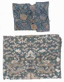
2 Antique Chinese Textile Fragments, 17th C. and 19th C.Material Culture4.6(778)See Sold PriceFeb 29, 2024
Willem Blaeu, Etc. 17th C. Antiquarian Maps, 2Auctions at Showplace4.6(740)See Sold PriceMar 17, 2024
Catherwood - General View of Uxmal, Taken from the Archway of Las Monjas, Looking SouthTrillium Antique Prints & Rare Books4.5(32)See Sold PriceFeb 24, 2024
D'Entrecasteaux - Australia: Coasts of Van Diemen's Land (New Holland). 9Trillium Antique Prints & Rare Books4.5(32)See Sold PriceFeb 24, 2024
D'Entrecasteaux - Tasmania, Australia: Map of the Northern Portion of Recherche Bay. 5Trillium Antique Prints & Rare Books4.5(32)See Sold PriceFeb 24, 2024
D'Entrecasteaux - Australia: Chart of Van Diemen's Land (New Holland). 3Trillium Antique Prints & Rare Books4.5(32)See Sold PriceFeb 24, 2024
D'Entrecasteaux - Map of Australia (New Holland), New Zealand, and southern Asia and surroundingTrillium Antique Prints & Rare Books4.5(32)See Sold PriceFeb 24, 2024
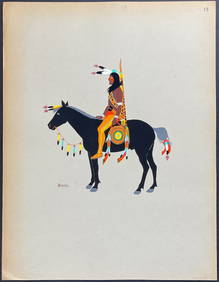
Kiowa Indian Art - Mopope: Kiowa Warrior on HorsebackTrillium Antique Prints & Rare Books4.5(32)See Sold PriceFeb 24, 2024
Kiowa Indian Art - Mopope: Kiowa Warrior and wifeTrillium Antique Prints & Rare Books4.5(32)See Sold PriceFeb 24, 2024
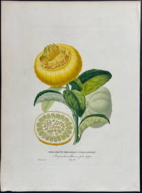
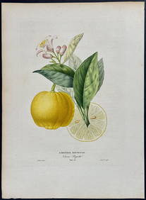
Risso - Lemon or Citrus Fruit. 73Trillium Antique Prints & Rare Books4.5(32)See Sold PriceFeb 24, 2024
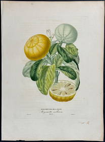
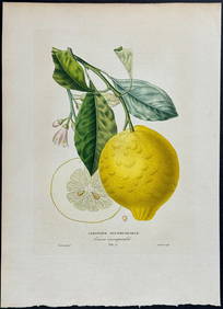
Risso - Lemon or Citrus Fruit. 71Trillium Antique Prints & Rare Books4.5(32)See Sold PriceFeb 24, 2024
Donovan's The Natural History of British Shells - 5 Volumes in 3 Books with 180 EngravingsTrillium Antique Prints & Rare Books4.5(32)See Sold PriceFeb 24, 2024
1675: ANTIQUE ILLUSTRATED JULIUS CAESAR MAPS OF ROMAN HISTORYNY Elizabeth 4.2(86)See Sold PriceMar 03, 2024